 Block
From the record
2 National Register listings published here.
Sources: the National Register database, National Park Service
32 topographic sheets cover 10 settlements here, and 2 properties are on the National Register of Historic Places.
2 National Register listings published here.
Sources: the National Register database, National Park Service
Every property in this county listed on the National Register of Historic Places, with the year it was listed and the federal nomination document.
| Photograph | Property | Type | Listed | Reference |
|---|---|---|---|---|
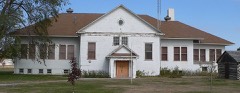 | Keya Paha County High School | building | 1986 | 86003377 |
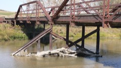 | Lewis Bridge | structure | 1992 | 92000774 |
Every wildfire the federal occurrence database records inside this county: 19 of them, burning about 9,254 acres. 5 started naturally and none was recorded as arson. Each settlement page carries the fires within five miles of it.
| Reported cause | Fires |
|---|---|
| Debris and open burning | 5 |
| Natural | 5 |
| Equipment and vehicle use | 5 |
| Missing data/not specified/undetermined | 3 |
| Recreation and ceremony | 1 |
The five largest, by the area the report gives. None of them was recorded as arson.
| Date | Cause | Size | Reported by | Name on the report |
|---|---|---|---|---|
| 23 July 2012 | Natural | 6,380 acres | Nebraska Forest Service | WENTWORTH |
| 23 July 2012 | Natural | 2,653 acres | Nebraska Forest Service | HALL |
| 19 March 2011 | Debris and open burning | 100 acres | Nebraska Forest Service | not named |
| 4 June 2011 | Debris and open burning | 50 acres | Fort Niobrara National Wildlife Refuge | DETERDING |
| 11 April 2020 | Debris and open burning | 20 acres | Nebraska Forest Service | not named |
| 23 November 2019 | Missing data/not specified/undetermined | 15 acres | Nebraska Forest Service | not named |
| 3 March 2020 | Debris and open burning | 14 acres | Nebraska Forest Service | not named |
| 13 October 2020 | Recreation and ceremony | 10 acres | Nebraska Forest Service | not named |
Every settlement page carries the fires within five miles of it - see the settlement index below.
The NOAA Storm Events Database holds 246 reports for this county, causing no deaths, 1 injury and about $4,022,450 in recorded property damage. Each settlement page carries the reports that name it.
| Kind of event | Reports |
|---|---|
| Hail | 181 |
| Thunderstorm Wind | 44 |
| Tornado | 11 |
| Flash Flood | 4 |
| Funnel Cloud | 3 |
| Flood | 3 |
The most serious of them, by death, then injury, then recorded damage. The accounts are quoted exactly as the forecast office filed them.
| When | Event | Place named | Harm | What the report says |
|---|---|---|---|---|
| May 2007 | Tornado (EF1) | Springview | 1 hurt, $100,000 | The cyclic supercell produced a tornado just as it entered southern Keya Paha County approximately 7 miles south southeast of Springview. The tornado tracked north northeastward for around 17 miles before lifting 5 miles north northeast of Burton. Along the path, the tornado took part of a roof off two homes, snapped trees, destroyed a barn and small outbuildings, overturned a center pivot irrigation system, and snapped 40 power poles. The tornado caused minor injuries to a gentleman that was on a farm tractor. |
| August 2021 | Thunderstorm Wind | Springview | $3,000,000 | Wind gust were estimated at 80 mph by public. Reports of several trees uprooted. A camper was rolled and a grain bin was damaged. Estimated a half mile of power poles snapped, power lost. |
| May 2010 | Tornado (EF2) | Norden | $120,000 | At 930 PM CDT, a tornado touched down approximately 12 miles northwest of Springview and traveled northeast for 20 minutes before lifting 11 miles north of Springview. The tornado did extensive tree damage when it touched down, then moved northeast and struck two farmsteads. At the first farmstead, a loafing shed and stock trailer were destroyed, extensive tree and fence damage occurred, and a roof was torn off an old hog building. The most extensive damage occurred north of the farmstead where six rural electric association poles where broken. The tornado continued to move northeast and destroy a windmill. Then a second farmstead was hit with the tornado destroying a 40 by 60 feet quonset building before the tornado lifted at 950 PM CDT. |
| May 2007 | Flash Flood | Springview | $120,000 | Heavy rains from thunderstorms caused flash flooding and washed out some bridges, roads, and culverts. Emergency management reported that 67 miles of roads were closed in the county. |
| June 1999 | Thunderstorm Wind | Springview | $100,000 | A storm system moved through Springview causing major damage to buildings, power poles and numerous trees. Surface wind estimates were 100 mph. The wind at the top of wind turbines west of Springview were measured at 136 mph about 200 feet above the surface. |
| July 1999 | Flash Flood | Countywide | $100,000 | Numerous roads and culverts were washed out. |
| August 2007 | Thunderstorm Wind | Springview | $80,000 | Thunderstorm wind gusts overturned 2 center pivots, damaged a wind mill and some small sheds and uprooted several trees. |
| March 2019 | Flood | Norden | $50,000 | Flooding reported along the Niobrara River south of Norden. |
| March 2019 | Flood | Springview | $50,000 | Heavy rainfall combined with snow melt and frost in the ground for ice jams that produced blocked roadways from large ice blocks and flood waters on Highway 7 in Keya Paha County along the Keya Paha and Niobrara rivers. |
| March 2009 | Thunderstorm Wind | Springview | $40,000 | The strong thunderstorm winds broke off large tree limbs, tore off the roof of a hay shed, overturned a center pivot irrigation system, damaged a grain bin, and overturned a corn crib. |
| June 2003 | Tornado (F0) | Mills | $30,000 | A tornado moved across a farmstead and produced major damage to a mechanics shop, a garage, and a grain bin. Numerous mature trees were also snapped off or uprooted. |
| June 2003 | Flash Flood | West Portion | $30,000 | Two paved county roads, Norden Road and Old Melch Road, south and southwest of Norden, respectively, were washed out. |
| June 1963 | Tornado (F1) | not stated | $25,000 | no account filed |
| June 2001 | Hail | Springview | $20,000 | no account filed |
| July 2001 | Hail | Norden | $20,000 | no account filed |
| August 2002 | Thunderstorm Wind | Mills | $15,000 | Severe tree damage occurred with the strong winds. Numerous large limbs were down. Some mature trees were broken off. Roads were blocked due to fallen limbs. |
| August 2007 | Hail | Springview | $15,000 | no account filed |
| August 2005 | Thunderstorm Wind | Springview | $10,000 | Thunderstorm outflow winds of 70 MPH moved two anchored sheds off of their foundations, broke large tree limbs and downed power lines. |
| August 2004 | Thunderstorm Wind | Springview | $10,000 | Thunderstorm outflow winds broke off large tree branches and snapped off power poles. |
| July 2000 | Hail | Springview | $10,000 | no account filed |
| July 2001 | Hail | Springview | $9,000 | no account filed |
| July 2001 | Hail | Springview | $8,000 | Small tree limbs down. |
| June 2008 | Hail | Mills | $5,000 | Wind driven hail broke all the windows on the north side of a house. Hail completely covered the ground. |
| August 2003 | Hail | Springview | $5,000 | Hail poked holes in vinyl siding on homes. |
| May 2000 | Thunderstorm Wind | Springview | $5,000 | Wind damage to shop building |
| July 1998 | Thunderstorm Wind | Springview | $5,000 | Several large tree limbs blown down. |
| August 2006 | Hail | Springview | $5,000 | no account filed |
| June 2003 | Hail | Springview | $5,000 | no account filed |
| July 2001 | Hail | Springview | $5,000 | no account filed |
| June 1999 | Hail | Springview | $4,000 | no account filed |
| August 2002 | Hail | Springview | $3,000 | no account filed |
| August 1997 | Hail | Springview | $3,000 | no account filed |
| July 1985 | Tornado (F1) | not stated | $2,500 | no account filed |
| June 1963 | Tornado (F2) | not stated | $2,500 | no account filed |
| June 2009 | Thunderstorm Wind | Mills | $2,000 | The strong thunderstorm winds took down power lines. |
| June 2008 | Hail | Mills | $2,000 | no account filed |
| April 2007 | Hail | Springview | $2,000 | no account filed |
| May 2007 | Hail | Mills | $1,200 | no account filed |
| July 2015 | Thunderstorm Wind | Springview | $1,000 | Thunderstorm wind gusts estimated at 60 MPH produced minor tree damage. |
| June 1999 | Thunderstorm Wind | Springview | $1,000 | At Sunny Brook Camp (20 miles west northwest of Springview) 10 to 12 inch tree branches were down and a canoe trailer was blown over. |
| August 2011 | Thunderstorm Wind | Burton | $500 | Thunderstorm wind gusts blew down several tree limbs up to 10 inches in diameter. |
| May 2000 | Thunderstorm Wind | Springview | $500 | Large tree down |
| June 1956 | Tornado (F2) | not stated | $250 | no account filed |
| April 2025 | Thunderstorm Wind | Springview | - | Thunderstorm wind gust of 62 MPH measured at this location. |
| July 2024 | Hail | Norden | - | Golf ball sized hail covering the ground at this location. |
| July 2024 | Hail | Springview | - | Nickel to quarter sized hail reported at this location. |
| May 2023 | Hail | Springview | - | Penny sized hail reported at this location. |
| July 2023 | Hail | Mills | - | Public reported hail up to baseball size, which damaged windows on the house north of Mills. |
| June 2021 | Hail | Burton | - | Hail up to the size of baseballs reported at this location. |
| July 2020 | Hail | Norden | - | Public reported quarter size hail west of Springview. |
| July 2020 | Hail | Norden | - | Public reported quarter size hail near Springview. |
| July 2020 | Thunderstorm Wind | Springview | - | Several power lines were downed in Springview. A roof was also torn off a building. |
| July 2020 | Hail | Norden | - | Public reported quarter size hail near Norden. |
| June 2020 | Thunderstorm Wind | Mills | - | Thunderstorm wind gusts, estimated at 60 MPH, brought 8 to 10 inch diameter tree limbs down at this location. |
| July 2019 | Flood | Mills | - | Emergency manager reported water covering many county roads. |
| May 2019 | Hail | Springview | - | Heavy rainfall reported along with quarter sized hail. |
| August 2019 | Funnel Cloud | Mills | - | Funnel cloud reported along the Nebraska/South Dakota state line. |
| July 2016 | Thunderstorm Wind | Springview | - | Public estimated a 60 mph wind gust southeast of Springview. |
| July 2015 | Thunderstorm Wind | Norden | - | Public estimated thunderstorm wind gusts to 80 MPH. |
| July 2015 | Thunderstorm Wind | Burton | - | Thunderstorm wind gusts estimated at 70 MPH. |
Named settlements recorded in the Geographic Names Information System, each with the topographic sheets covering it. Villages, hamlets and abandoned places alike. Each is shown with the nearest named watercourse or landform and the survey quadrangle it falls on.
Mills precinct · 68759 · On Spotted Tail Creek · Jamison quadrangle
9 sheets, 1955 to 1989
Custer precinct · 68778 · On Tarbell Creek · Carns quadrangle
11 sheets, 1949 to 1989
No longer a settlement
Norden precinct · 69220 · On Coleman Creek · Muleshoe Creek quadrangle
11 sheets, 1950 to 1985
The vanished settlements of Keya Paha County: the places named above that are no longer on the map.