 Block
From the record
One of 30 National Register listings published here for Gage County · listed in 1997 · category: Building.
Sources: the case file at the National Archives · the National Register database, National Park Service
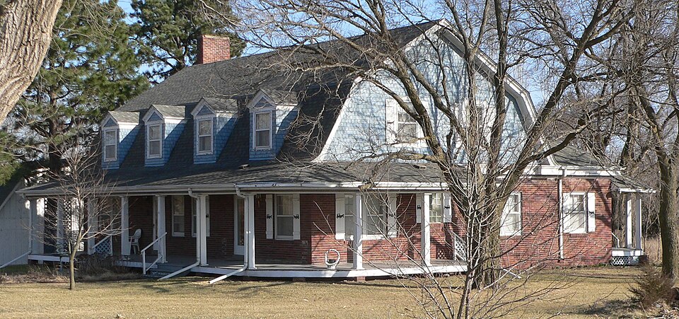
Listed on the National Register of Historic Places in 1997.
One of 30 National Register listings published here for Gage County · listed in 1997 · category: Building.
Sources: the case file at the National Archives · the National Register database, National Park Service
Regional context, not property-specific evidence. The federal wildfire occurrence database lists 77 fires within 5 miles of Institution for Feeble Minded Youth Farm between 2007 and 2020, burning about 425 acres in total. 1 started naturally. 3 were recorded as arson. Distance is straight-line from the map coordinates, so a fire counted here may appear on a neighbouring settlement's page as well.
| Reported cause | Fires |
|---|---|
| Debris and open burning | 36 |
| Missing data/not specified/undetermined | 21 |
| Equipment and vehicle use | 5 |
| Fireworks | 5 |
| Arson/incendiarism | 3 |
| Power generation/transmission/distribution | 2 |
| Smoking | 2 |
| Recreation and ceremony | 1 |
| Misuse of fire by a minor | 1 |
| Natural | 1 |
The most recent of them, most recent first, with the day each was reported and the service that recorded it.
| Date | Cause | Size | Reported by | Name on the report |
|---|---|---|---|---|
| 27 August 2011 | Power generation/transmission/distribution | under an acre | Nebraska Forest Service | not named |
| 22 August 2007 | Missing data/not specified/undetermined | under an acre | Nebraska Forest Service | not named |
| 7 July 2012 | Equipment and vehicle use | 2.0 acres | Nebraska Forest Service | not named |
| 4 July 2012 | Fireworks | under an acre | Nebraska Forest Service | not named |
| 4 July 2007 | Fireworks | under an acre | Nebraska Forest Service | not named |
| 3 July 2014 | Missing data/not specified/undetermined | under an acre | Nebraska Forest Service | not named |
| 2 July 2007 | Fireworks | 1.0 acres | Nebraska Forest Service | not named |
| 17 July 2008 | Natural | under an acre | Nebraska Forest Service | not named |
Regional context, not property-specific evidence. The National Weather Service names Beatrice, the town this property stands in, in 121 storm reports between 1993 and 2026: 52 hail, 42 thunderstorm wind, 10 flash flood, 5 heavy rain. The reports record 1 death and 18 injuries. Each account below is quoted exactly as the forecast office filed it, from the NOAA Storm Events Database, and each date opens the federal record of that event.
| When | Event | Place named | Harm | What the report says |
|---|---|---|---|---|
| April 2006 | Lightning | Beatrice | 1 killed, 3 hurt | Lightning struck and killed a 14 year-old female during a pick-up soccer game. Three others were injured, one seriously. |
| May 1996 | Tornado (F2) | Beatrice | 15 hurt, $12,000,000 | no account filed |
| May 2007 | Flood | Beatrice | $650,000 | Rainfall of 4 to 5 inches fell over much of the Big Blue River basin in Gage county from Friday May 4th through Sunday May 6th, with 4.26 inches reported in Beatrice. The heavy rain caused the Big Blue River to flood with both the gage in Beatrice and near Barneston reporting above flood stage readings for a few days. In Beatrice the Big Blue River reached a 23.9 foot crest around 230 pm CDT on May 7th, flood stage 16 feet. The river first crossed flood stage in Beatrice around 815 am on May 6th and didn't drop below flood stage until 730 am on the 9th.|At Barneston the Big Blue River reached a 24.5 foot crest around 345 pm CDT on May 7th, flood stage is 20 feet. The river near Barneston was above flood stage from around 1000 pm CDT May 6th until 315 am on the 9th.|The river flooded agricultural farmland and county roads in the region. Seven county roads were flooded from Beatrice toward Blue Springs and Wymore. Highway 136 was also closed late May 6th through May 7th around the Beatrice area because of high water that also flooded a park and some streets in town causing around $135,000 worth of damage to the park and ballfields. Two businesses had to be evacuated in Beatrice. The flood waters also prompted 5000 sandbags to be placed around a historical museum to keep flood waters from damaging historic items. Also a grain elevator near Holmesville, several miles southeast of Beatrice, was also sandbagged to protect from the rising waters. Total damage from the storms that hit Gage county on May 5th and 6th amounted to around $650,000, most of which was due to flooding. |
| April 2001 | Hail | Beatrice | $20,000 | Hail up to 1 inch in diameter damaged some windows in Beatrice including the marquee at the Cinema Centre on Court St. in Beatrice. |
| July 1997 | Flash Flood | Beatrice | $8,000 | Heavy rains enveloped a grain elevator and washed out a section of railroad tracks next to it. |
| May 2007 | Thunderstorm Wind | Beatrice | $5,000 | Thunderstorm winds estimated at 60 mph destroyed a machine shed south of Beatrice. |
| May 1995 | Tornado (F0) | Beatrice | $5,000 | An off duty police officer had truck thrown off the road into a ditch. The liner was ripped out of his vehicle. |
| April 1998 | Lightning | Beatrice | $4,000 | no account filed |
| May 1996 | Lightning | Beatrice | $1,000 | no account filed |
| April 2026 | Hail | Beatrice | - | Trained spotter report of hail measured up to 1 inch in diameter in Beatrice, NE. |
| April 2026 | Hail | Beatrice | - | Trained spotter report of hail measured up to 1.50 inches in diameter in Beatrice, NE. |
| April 2026 | Hail | Beatrice | - | Trained spotter report of hail measured up to 1.50 inch in diameter in Beatrice, NE. |
| July 2025 | Heavy Rain | Beatrice | - | Rainfall report received via social media of 2.50 inches of rain on the north side of Beatrice, NE. |
| July 2025 | Heavy Rain | Beatrice | - | Personal weather station report of 2.25 inches of rain. |
| July 2025 | Heavy Rain | Beatrice | - | Personal weather station report of 3.14 inches of rain. |
| April 2024 | Hail | Beatrice | - | The office received a delayed report from the public of hail ranging from 1 to 1.5 inches in diameter. |
| June 2024 | Thunderstorm Wind | Beatrice | - | A 62 miles per hour wind gust was recorded by a personal weather station. |
| May 2023 | Thunderstorm Wind | Beatrice | - | A trained spotter reported a measured peak wind gust of 62 mph. |
| July 2023 | Thunderstorm Wind | Beatrice | - | Emergency manger reported multiple large trees down. |
| July 2023 | Thunderstorm Wind | Beatrice | - | Trained spotter reported multiple large trees down in Beatrice. |
| August 2023 | Hail | Beatrice | - | Fire Department reported wind driven 1-inch hail that stripped crops. |
| June 2022 | Hail | Beatrice | - | Trained spotter reported 1.5 inch hail. |
| June 2022 | Hail | Beatrice | - | Public reported 1.75 inch hail via mPing. |
| June 2022 | Hail | Beatrice | - | Emergency manager reported 1-inch hail. |
| June 2022 | Hail | Beatrice | - | Broadcast media received report and photo of 5 inch hail. |
| June 2022 | Hail | Beatrice | - | Public reported grapefruit sized hail. |
| June 2022 | Hail | Beatrice | - | Public reported via mPing 3.25 inch hail. |
| December 2021 | Thunderstorm Wind | Beatrice | - | Beatrice AWOS measured a peak wind gust of 86 mph. |
| June 2020 | Thunderstorm Wind | Beatrice | - | Public reported a large tree split due to severe storms. |
| October 2020 | Thunderstorm Wind | Beatrice | - | Beatrice Airport AWOS measured a peak wind gust of 63 mph. |
| October 2020 | Thunderstorm Wind | Beatrice | - | Public via social media reported a large tree down on power lines with additional trees down in Beatrice. |
| October 2020 | Thunderstorm Wind | Beatrice | - | Beatrice ASOS measured a peak wind gust of 51 knots. |
| July 2020 | Thunderstorm Wind | Beatrice | - | Public estimated 60 mph winds in Beatrice and reported lights flickering in town. |
| July 2020 | Thunderstorm Wind | Beatrice | - | Public reported a 66 mph wind. |
| July 2020 | Thunderstorm Wind | Beatrice | - | Public reported tree damage and limbs down. |
| June 2020 | Heavy Rain | Beatrice | - | Mesonet station recorded 24-hour rain total of 5.58 inches. |
| June 2020 | Flood | Beatrice | - | River gage operated by Department of Natural Resources was above flood stage for approximately 30 hours. |
| April 2019 | Hail | Beatrice | - | The public reported 1.25 hail. |
| April 2019 | Hail | Beatrice | - | The public reported nickel size hail. |
| March 2019 | Flood | Beatrice | - | Highway 136 bridge over the Big Blue River is being closed. |
| June 2019 | Thunderstorm Wind | Beatrice | - | Law enforcement reported a tree was blown down in Beatrice. |
| August 2019 | Thunderstorm Wind | Beatrice | - | Numerous trees and large limbs blown down in Beatrice. Some homes had small holes in their roofs. |
| September 2018 | Thunderstorm Wind | Beatrice | - | Large tree branches were broken. |
| June 2017 | Thunderstorm Wind | Beatrice | - | Trees and power lines were blown down by damaging winds on the west part of Beatrice. A professional building lost a small portion of it's roof. |
| September 2015 | Thunderstorm Wind | Beatrice | - | In addition to the penny size hail, the emergency manager reported winds to near 60 mph as well. |
| June 2014 | Thunderstorm Wind | Beatrice | - | The wind gust caused significant damage in and near Beatrice. Included in the damage were trees blowing into structures, at least two buildings destroyed just east of highway 77 on the north side of Beatrice, and transmission lines blown down. |
| October 2013 | Thunderstorm Wind | Beatrice | - | A wind gust to 61 mph was recorded at the Beatrice Airport. Local law enforcement indicated only a few small branches to around 1 inch in diameter were downed in town. |
| May 2013 | Thunderstorm Wind | Beatrice | - | The public reported winds gusts to near 60 mph in the city of Beatrice. This resulted in downed tree branches in the city of Beatrice. |
| May 2013 | Tornado (EF0) | Beatrice | - | A NWS storm survey revealed a weak tornado developed about 2 miles southwest of Beatrice and traveled northeast for just over a mile before dissipating. The tornado was weak producing damage consistent with EF0 consisting of broken hardwood tree branches and minor damage to outbuildings. |
| May 2013 | Flash Flood | Beatrice | - | Heavy thunderstorm rains of 2 to 3 inches fell across the city of Beatrice. This led to several intersections in the city to become flooded. |
| April 2012 | Thunderstorm Wind | Beatrice | - | Thunderstorm wind gusts estimated at around 60 mph downed large tree branches and damaged a barn in the area. |
| August 2011 | Thunderstorm Wind | Beatrice | - | Thunderstorm wind gusts estimated at close to 60 mph caused scattered tree damage in the Beatrice area. |
| August 2009 | Thunderstorm Wind | Beatrice | - | Thunderstorm winds measured at 60 to 70 mph downed a few trees and numerous large tree limbs in town. |
| May 2008 | Thunderstorm Wind | Beatrice | - | Thunderstorm wind gusts estimated at close to 60 mph blew a tree onto a house in town causing damage. |
| July 2008 | Heavy Rain | Beatrice | - | Around 4.5 inches of rain was reported in a few hours time south of Beatrice. |
| May 2008 | Thunderstorm Wind | Beatrice | - | A bow echo that moved across the Beatrice area brought a thunderstorm wind gust that was measured at 61 mph at the Beatrice airport Awos. The strong winds caused scattered tree damage around town. However, the bow echo brought more substantial damage in two paths, one from a tornado on the north end of the cell north through northeast of town, and the other from straight line winds south through east of town. |
| October 2007 | Hail | Beatrice | - | Nickel size hail was reported by a spotter on the southwest part of town. |
| March 2007 | Hail | Beatrice | - | Hail up to nickel size was reported for around 5 minutes near Beatrice. |
| May 2007 | Flash Flood | Beatrice | - | Heavy rainfall of an inch or two in an hour or so produced extensive street flooding in Beatrice. |
| May 2007 | Hail | Beatrice | - | Accompanied by winds around 60 mph. |
No historic map-sheet match is published for this property yet. That does not mean no map exists. This record needs a coordinate-quality review before it can be joined to a sheet boundary. Browse the county's mapped places while that work is pending.
Other National Register properties close enough to walk or drive between, ordered by distance from this one. Both positions come from the same geocoding pass that matched these properties to their map sheets.
| Photograph | Property | Distance | Listed |
|---|---|---|---|
| North Eleventh Street Historic District | 2.7 miles | 2010 | |
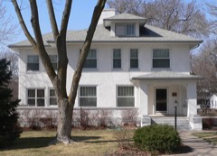 | Rachel Kilpatrick Purdy House | 2.7 miles | 2006 |
| Algernon S. Paddock House | 2.8 miles | 1973 | |
| North Seventh Street Historic District | 3.0 miles | 2010 | |
 | Samuel D. Kilpatrick House | 3.0 miles | 1984 |
 | Gage County Courthouse | 3.0 miles | 1990 |
| National Archives record | The nomination case file for reference 97001521 in Record Group 79. |
| Gage County | All 30 listed properties in this county. |