 Block
From the record
One of 22 National Register listings published here for Chaves County · listed in 2019 · category: Structure.
Sources: the National Register database, National Park Service
Listed on the National Register of Historic Places in 2019.
One of 22 National Register listings published here for Chaves County · listed in 2019 · category: Structure.
Sources: the National Register database, National Park Service
Regional context, not property-specific evidence. The federal wildfire occurrence database lists 103 fires within 5 miles of Henge, The between 1992 and 2019, burning about 1,047 acres in total. 8 started naturally. 4 were recorded as arson. Distance is straight-line from the map coordinates, so a fire counted here may appear on a neighbouring settlement's page as well.
| Reported cause | Fires |
|---|---|
| Missing data/not specified/undetermined | 45 |
| Debris and open burning | 23 |
| Equipment and vehicle use | 13 |
| Natural | 8 |
| Arson/incendiarism | 4 |
| Fireworks | 3 |
| Smoking | 3 |
| Power generation/transmission/distribution | 3 |
| Firearms and explosives use | 1 |
The most recent of them, most recent first, with the day each was reported and the service that recorded it.
| Date | Cause | Size | Reported by | Name on the report |
|---|---|---|---|---|
| 30 September 1999 | Debris and open burning | under an acre | Roswell Field Office | GALLINA |
| 3 September 2019 | Equipment and vehicle use | 1.1 acres | Capitan District | 20-50610222X |
| 29 September 2011 | Arson/incendiarism | 1.0 acres | Bitter Lake National Wildlife Refuge | SQUIRREL |
| 27 September 1999 | Missing data/not specified/undetermined | under an acre | Roswell Field Office | ISLER |
| 22 August 1994 | Debris and open burning | 4.0 acres | Roswell Field Office | SHEPHERD |
| 19 August 1994 | Debris and open burning | 1.0 acres | Roswell Field Office | MM339 |
| 9 July 1993 | Natural | under an acre | Roswell Field Office | DONNA ANNA |
| 8 July 2016 | Natural | 13 acres | Bitter Lake National Wildlife Refuge | LOST |
Regional context, not property-specific evidence. The federal mineral resources record lists 4 workings within 5 miles of Henge, The: 3 unknowns, 1 past producer. None of them still produces. What was taken out: Sand and Gravel, Construction, Gemstone. Distance is straight-line from the map coordinates, so a quarry counted here may appear on a neighbouring settlement's page as well.
| Where | Site | Commodity | Status | Recorded |
|---|---|---|---|---|
| Pecos River Valley | Gemstone | Past Producer | Sedimentary | |
| Gravel Pits | Sand and Gravel, Construction | Unknown | ||
| Gravel Pits | Sand and Gravel, Construction | Unknown | ||
| Gravel Pits | Sand and Gravel, Construction | Unknown |
Regional context, not property-specific evidence. The National Weather Service names Roswell, the town this property stands in, in 164 storm reports between 1993 and 2025: 92 hail, 28 thunderstorm wind, 17 flash flood, 12 tornado. The reports record 1 death and 2 injuries. Each account below is quoted exactly as the forecast office filed it, from the NOAA Storm Events Database, and each date opens the federal record of that event.
| When | Event | Place named | Harm | What the report says |
|---|---|---|---|---|
| October 2024 | Flash Flood | Roswell | 1 killed, $500,000,000 | Historically bad flash flooding across Roswell, reported by numerous emergency officials and the public. Thunderstorms training over Roswell dumped an all-time one-day rainfall record of 5.78 at the Roswell Airport with numerous other public weather stations across town ranging from 4 to 9 inches. Major flooding was reported across the city and nearby low-lying areas south and west of town. Numerous vehicles were submerged in over 4 feet of water while several more were swept away. The Roswell Daily Record reported that as many as 500 rescues were carried out over the weekend during and after the flooding. Estimates have as many as 400 homes and 200 businesses facing significant damage. The Roswell Convention Center was hosting a UFO festival when flood waters up to 5 feet entered the building. Attendees were being rescued from the rooftop. Roswell's Spring River Zoo also suffered extensive damage including the loss of one donkey. Flood damage was also sustained to Roswell's Landfill and Wastewater Treatment Plant. All roads entering the city were closed by State Police. The city lost 4 fire trucks and 7 police patrol cars with numerous city facilities damaged. There is one confirmed direct fatality from drowning and one indirect fatality from a heart attack reported and there may have been more as many vehicles were swept away along the Spring River drainage. |
| August 1997 | Thunderstorm Wind | Roswell | 1 hurt, $750,000 | no account filed |
| June 2005 | Thunderstorm Wind | Roswell | 1 hurt | no account filed |
| August 2022 | Flood | Roswell | $500,000 | A long duration rain event caused the Pecos River in Chaves County to swell and cause major flooding around the river. Once the Acme gauge to the northeast of Roswell crested to major flood stage, that water slowly traveled south for several days, causing flooding in the Dexter, Hagerman, and Lake Arthur areas. The gauge at Lake Arthur crested to a maximum of 13.37 feet at about 6:45 PM MDT on August 26th. Despite this being well below action stage, major impacts were still felt for several days across southern Chaves County along the Pecos River. During the early morning hours of the 21st, a vehicle attempting to cross a flooded low water crossing was carried about a half mile downstream along Cherokee Road near Hagerman. A water rescue was conducted for the driver who was found sitting on the top of their partially submerged vehicle. Along River Road at Bottomless Lakes, four people had to be rescued. Two of these individuals were rescued from a trapped vehicle while the other two were rescued from the home after they previously chose not to evacuate. Finally, near Dexter, three people had to be rescued from their vehicle. This water rescue proved to be particularly difficult as the flood waters at this point were too high which prevented emergency officials from reaching the stranded travelers. Officials had to drive around Dexter and approach the location from the east to rescue the three individuals. Despite all this, there were no known injuries and damages are a rough estimate. |
| June 2022 | Flash Flood | Roswell | $500,000 | Over three inches of rain in Roswell caused significant flooding on the northeast side of the city. At least twelve homes in the Holly Loop subdividion were flooded, and emergency crews had to divert water through cinder block walls away from the subdivision and onto East Country Club Road. Farther east, a small bridge collapsed at East Mescalero Road near La Jara Road due to flood waters in Borrendo Creek. Damages are estimated. |
| September 2021 | Flash Flood | Roswell | $150,000 | One to three inches of heavy rainfall in a short period of time caused flash flooding in Roswell. The north and northeast side of the city experienced the most severe flooding where multiple cars were stranded on flooded roadways. Numerous water rescues were conducted on Atkinson, Mescalero, and Berrendo roads in northern Roswell. Flood waters entered homes on Holly Loop, and the road was barricaded due to high water rises. Damages are estimated. |
| September 2013 | Flood | Roswell | $100,000 | Portions of NM 246 washed out between mile markers 36 and 61. |
| September 2013 | Flood | Roswell | $80,000 | Several vehicles rescued along US 70 relief route due to Rio Hondo flooding. Water rescue also occurred along NM 246 near Berrendo Creek. River Road was closed along the Pecos River and a small neighborhood was evacuated with 3 houses flooded. A Red Cross shelter was opened and 2 people stayed overnight. |
| July 2021 | Flash Flood | Roswell | $50,000 | Heavy rain resulted in numerous roadways, yards, and ditches to be flooded across Roswell. Damages are estimated. |
| June 2018 | Thunderstorm Wind | Roswell | $50,000 | Power lines reported down in and around Roswell. Damage amounts are a very rough estimate. |
| December 1993 | Thunderstorm Wind | Roswell | $50,000 | no account filed |
| April 2004 | Thunderstorm Wind | Roswell | $40,000 | no account filed |
| August 2020 | Lightning | Roswell | $25,000 | Fire from a lightning strike northeast of Roswell destroyed a residential structure. Structure was an abandoned mobile home so fortunately, no injuries were reported. Damage amounts are a rough estimate. |
| June 2025 | Thunderstorm Wind | Roswell | $20,000 | Utility poles blown down with arcing powerlines and electric service disrupted for residents in Roswell. Damage is an estimate. |
| May 2015 | Tornado (EF0) | Roswell | $20,000 | Trained spotters and the public reported multiple cold-air funnels developing over the Roswell area. Reports indicated that one cold air funnel cloud briefly made contact with the ground and damaged the roof and walls of two outbuildings. No injuries or fatalities were reported with this tornado. |
| May 2014 | Thunderstorm Wind | Roswell | $20,000 | A 3 foot diameter tree was felled and resulted in damagd to a nearby automobile and powerlines. No injuries were reported. |
| September 2013 | Flood | Roswell | $20,000 | The Rio Hondo at Diamond A Ranch experienced its 5th highest crest of 29,500 cfs around 4am on the 11th. This led to the 2nd highest crest at Roswell of 1,920 cfs around 815pm on the 12th. The US 70 relief route southwest of Roswell was flooded by the Rio Hondo as a result. Cars were stranded and water rescued took place. |
| June 2007 | Thunderstorm Wind | Roswell | $20,000 | The winds blew down power lines which in turn produced a structure fire. |
| June 2015 | Thunderstorm Wind | Roswell | $15,000 | Spotter passed along pictures of large tree limb blown over by thunderstorm wind gust in Roswell. |
| June 2011 | Thunderstorm Wind | Roswell | $15,000 | A roof was blown off a home on the southwest side of Roswell. |
| May 1998 | Hail | Roswell | $15,000 | Several cars were heavily damaged by large hail that fell 10-15 miles north of Roswell along Highway 285. |
| September 2015 | Flash Flood | Roswell | $10,000 | Emergency manager reported widespread street flooding in Roswell. Later reports and information showed road closures in the northeast portion of the city near the Anderson Museum of Contemporary Art, notably North Virginia Road and North Garden Road. There were unconfirmed reports of swift water rescues in the area as well. Rainfall reports from trained spotters and the CoCoRaHS network around the area showed up to 3.68 inches of rain fell, with many reports in excess of 2.5 inches. |
| October 2009 | Thunderstorm Wind | Roswell | $10,000 | Five telephone poles were snapped along Highway 70, about 4 miles west of Roswell. |
| July 1997 | Thunderstorm Wind | Roswell | $10,000 | A late night storm over Roswell damaged sheds and downed power lines. Gusts of 55 to 60 mph were recorded at the airport and across the city. |
| May 2007 | Thunderstorm Wind | Roswell | $10,000 | no account filed |
| June 2005 | Thunderstorm Wind | Roswell | $10,000 | no account filed |
| May 2025 | Hail | Roswell | $5,000 | A driver on U.S. Highway 380 and 70 just west of Roswell reported quarter to ping pong ball size hail resulting in damage to his vehicle windshield and exterior roof. |
| May 2014 | Flash Flood | Roswell | $5,000 | Police and Fire Departments closed numerous roads in Roswell. |
| July 2009 | Thunderstorm Wind | Roswell | $5,000 | Several pieces of metal were blown off storefront facade near 2nd and Main Street as well as up to 8 inch diameter tree limbs broken off trees within a few blocks of the courthouse. This was reported by KRQE News Channel 13. |
| June 2003 | Thunderstorm Wind | Roswell | $5,000 | Gusty and mostly dry thunderstorm winds swept across Roswell damaging car coverings and downing a number of power lines. |
| April 2009 | Hail | Roswell | $4,000 | Golf ball size hail was reported along Pine Lodge Road or Highway 246 northwest of Roswell. One citizen reported hail dents to their family vehicle. |
| October 2015 | Flash Flood | Roswell | $3,000 | New Mexico State road 246 closed between mile markers 59 and 60 due to flooding over the roadway. |
| August 1998 | Heavy Rain | Roswell | $2,000 | A slow moving thunderstorm northwest of Roswell produced about 3.00 inches of rain and brief flooding of one rural home. |
| September 2007 | Thunderstorm Wind | Roswell | $2,000 | no account filed |
| May 2014 | Flash Flood | Roswell | $1,000 | Major street flooding was reported in Roswell. Flood waters were up to automobile doors. The Rio Hondo was nearly out of its banks at Sunset Avenue in Roswell. |
| July 2009 | Thunderstorm Wind | Roswell | $500 | A trampoline was blown into power lines. |
| May 2025 | Hail | Roswell | - | Pea to nickel size hail a few blocks southwest of downtown Roswell, with a few ping-pong ball size stones reported. |
| June 2025 | Hail | Roswell | - | The public reported quarter size hail that lasted until 5:20 pm MDT. |
| June 2025 | Flash Flood | Roswell | - | Multiple cars and a fire truck stuck in deep water. Damage is unknown. |
| November 2024 | Flash Flood | Roswell | - | Video shows the water flowing over Bottomless Lakes Road north of Bottomless Lakes State Park. The road was closed due to being impassible from the floodwaters. Additionally, water was flowing across U.S. Highway 380 at mile marker 177 and at a rest stop next to the Mescalero Sands North Dune area. |
| October 2024 | Flood | Roswell | - | Historically bad flash flooding across Roswell from storms dropping 4 to 9 inches across town, including an all-time one-day precipitation record of 5.78 at the Roswell airport caused major damage. This flooding was reported to have persisted through Monday October 21st. Damage and fatality information are recorded in the preceding flash flood entry. |
| October 2024 | Flood | Roswell | - | Heavy rains resulting in the devastating flash flooding in Roswell swelled the Pecos River on October 20th, reaching the Lake Arthur gauge near the southern Chaves County line. River levels surpassed minor flood level at 20 feet at 17:30 MST, peaking at 20.34 feet at 7:30pm MST before receding below minor flood stage at 11:45pm MST that night. |
| May 2021 | Hail | Roswell | - | Nickel size hail was reported with a strong thunderstorm northwest of Roswell near the intersection of Brown Road and Relief Route. |
| May 2021 | Hail | Roswell | - | Penny size hail from a strong thunderstorm was reported in Roswell. |
| May 2021 | Thunderstorm Wind | Roswell | - | An observer at 2nd and Union in Roswell measured a 65 mph thunderstorm wind gust associated with a severe thunderstorm that was moving northeastward through the area. |
| May 2021 | Hail | Roswell | - | A storm chaser reported 1 inch hail from a severe thunderstorm near Roswell. The slow-moving thunderstorm produced sufficient hail to partially cover U.S. Highway 380, but no impacts were reported. |
| March 2021 | Hail | Roswell | - | A strong thunderstorm near Roswell produced brief hail with the largest hailstones estimated to be about 0.75. |
| July 2021 | Hail | Roswell | - | A Roswell resident reported golf ball size hail from a severe thunderstorm tracking northeastward through the area. |
| June 2019 | Hail | Roswell | - | Quarter size hail reported west of Roswell. |
| May 2018 | Hail | Roswell | - | Hail up to the size of half dollars, with some as large as hen eggs, reported 18 miles northwest of Roswell. |
| May 2018 | Hail | Roswell | - | Hail up to the size of golf balls 10 miles west of Roswell. |
| May 2018 | Hail | Roswell | - | Hail up to the size of ping pong balls 17 miles west of Roswell on U.S. Highway 70. |
| October 2018 | Hail | Roswell | - | Hail up to the size of pennies seven miles north-northwest of Roswell. |
| May 2017 | Hail | Roswell | - | Nickel to quarter size hail on the west side of Roswell. |
| May 2017 | Hail | Roswell | - | A second thunderstorm moved into Roswell and produced nickel size hail. |
| May 2017 | Hail | Roswell | - | Hail up to the size of golf balls on the west side of Roswell. |
| May 2017 | Hail | Roswell | - | Hail up to the size of nickels on the northwest side of Roswell. |
| May 2017 | Hail | Roswell | - | A third severe thunderstorm moving across Roswell produced quarter size hail on the northwest side of town. |
| May 2017 | Hail | Roswell | - | Quarter to half dollar size hail covered the ground in Roswell. |
| May 2017 | Hail | Roswell | - | Quarter size hail at Wyoming and Alameda in Roswell. |
1 paper published in this town, digitised by the Library of Congress and free to read: 2,092 issues, 8,586 pages. Every page is searchable, so a name or a street can be looked for directly in what the town printed about itself at the time.
| Newspaper | Published |
|---|---|
| The Roswell Daily Record | 1903 to Current |
No historic map-sheet match is published for this property yet. That does not mean no map exists. This record needs a coordinate-quality review before it can be joined to a sheet boundary. Browse the county's mapped places while that work is pending.
Other National Register properties close enough to walk or drive between, ordered by distance from this one. Both positions come from the same geocoding pass that matched these properties to their map sheets.
| Photograph | Property | Distance | Listed |
|---|---|---|---|
| Milne-Bush Ranch | 0.2 miles | 1988 | |
| Robert H. Goddard House | 0.7 miles | 1988 | |
| Urton Orchards | 0.8 miles | 1988 | |
| Roswell Artist-in-Residence Compound | 2.5 miles | 2017 | |
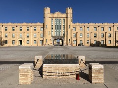 | New Mexico Military Institute Historic District | 2.5 miles | 1987 |
| Downtown Roswell Historic District (Boundary Increase) | 2.7 miles | 2002 |
| National Archives record | The nomination case file for reference 100004221 in Record Group 79. |
| Chaves County | All 22 listed properties in this county. |