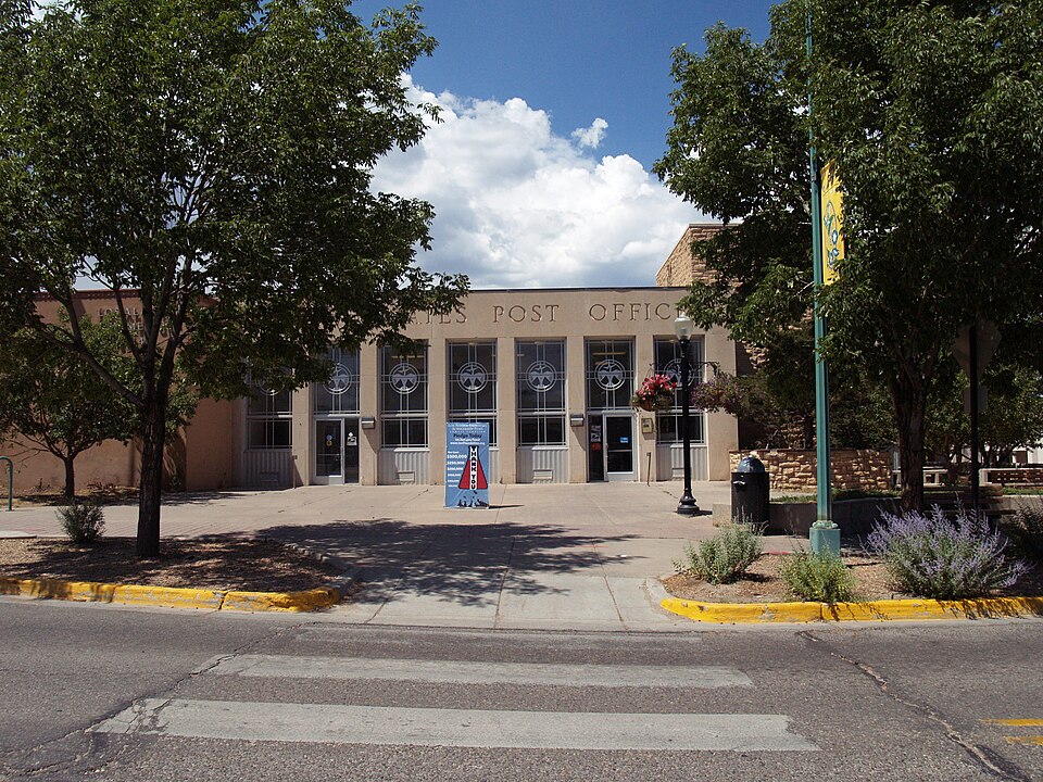
Listed on the National Register of Historic Places in 2015.
From the record
“The Los Alamos United States Post Office, at 199 Central Park Sq. in Los Alamos, New Mexico, was listed on the National Register of Historic Places in 2015 as United States Post Office-Los Alamos, New Mexico.”
Wikipedia article Los Alamos United States Post Office, CC BY-SA 4.0.
One of 8 National Register listings published here for Los Alamos County · listed in 2015 · category: Building.
National Register reference number. 15000493 - assigned by the National Park Service when the property was listed.
Fires near this property
139 since 1992
Regional context, not property-specific
evidence. The
federal wildfire occurrence database
lists 139 fires within 5 miles of United States Post Office-Los Alamos, New Mexico
between 1992 and 2020, burning about 358 acres in total. 103 started naturally. 6 were recorded as arson.
Distance is straight-line from the map coordinates, so a fire counted
here may appear on a neighbouring settlement's page as well.
Reported cause
Fires
Natural
103
Recreation and ceremony
16
Missing data/not specified/undetermined
9
Arson/incendiarism
6
Debris and open burning
2
Power generation/transmission/distribution
2
Misuse of fire by a minor
1
The most recent of
them, most recent first, with the day each was reported and the service
that recorded it.
Regional context, not property-specific
evidence. The federal mineral resources record lists
3 workings within 5 miles of United States Post Office-Los Alamos, New Mexico: 3 producers.
All of them still produce. What was taken out: Pumice. Distance is straight-line from the
map coordinates, so a quarry counted here may appear on a neighbouring
settlement's page as well.
Regional context, not property-specific
evidence. The National Weather Service names
Los Alamos, the town this property stands in, in 34 storm reports between 2000 and 2024: 19 hail, 12 flash flood, 1 wildfire, 1 dust devil.
No death or injury is recorded in these reports. Each account below is quoted exactly as the forecast office
filed it, from the NOAA Storm Events Database, and each date
opens the federal record of that event.
After 1 to 1.5 inches of rain fell on the northern portion of the Las Conchas burn scar, flash flooding was reported in Santa Clara Canyon. Four people that were working in the canyon had to be rescued by helicopter.
Brief heavy rain and strong runoff caused more damage to North Road in Los Alamos where recent drainage upgrades and repairs were washed away. North Road continues to suffer damage with such rapid and high runoff from the burned areas of Pueblo Canyon which have not recovered from last years Cerro Grande fire storm.
Mud, logs and large rocks washed onto State Road 501 (West Jemez Rd.) near State Road 4, as well as in Los Alamos Canyon and along Camp May road. Heavy equipment and road graders were needed to clear the debris.
Newspaper report with images of significant hail damage to a mobile home in Los Alamos. Home owners reported hail was ping pong ball sized. Location is estimated from article giving home address. Time is estimated, based on radar imagery and other hail reports in the area. All images attached to this event are courtesy of the Los Alamos Daily Post newspaper.
Los Alamos Sky Cam and pictures from local residents showed significant accumulations of pea to penny size hail in downtown Los Alamos from a thunderstorm. Hail accumulation depth looked to be around 2 to 3 inches based on tire track marks on the road.
Lightning splintered a tree at the Los Alamos Golf Course near 16 Los Alamos High School Golf Team members and four coaches. The strike occurred at around 4 pm, about 300 feet away from where the team was practicing. Several of the students reported feeling a strong static electricity sensation flow through their bodies. Fortunately, no injuries occurred.
Power outages as well as flooding in the basement at Los Alamos National Labs were reported. An isolated strong cell formed over the area and stayed generally stationary for 2 hours. Rainfall amounts over 1.5 were recorded at sites across LANL.
Water and debris flowed over Highway 501 after approximately one inch of rain fell over central portions of the Las Conchas burn scar. The highway was temporarily closed.
Both Highway 4 and 501 were closed in the Jemez Mountains due to flooding. Heavy rains on the Las Conchas burn scar caused significant runoff and debris flow over the roadways. At least a 50 yard stretch of debris several inches deep was noted along State Highway 501. Both roads had to be cleared by the Highway Department before traffic was allowed to pass.
A brief and intense hail storm with stones ranging form one half inch to one inch in diameter covered city streets and parking lots to a depth of 4 to 8 inches.
No historic map-sheet match is published
for this property yet. That does not mean no map exists. This record needs
a coordinate-quality review before it can be joined to a sheet boundary.
Browse the county's mapped places while that work is
pending.
Listed places nearby
6 within 8 miles
Other National Register properties close
enough to walk or drive between, ordered by distance from this one. Both
positions come from the same geocoding pass that matched these properties
to their map sheets.
Listing record. National Park Service National Register of Historic Places, listed-properties dataset, current to 2026-05-22.
Map join. Address geocoded through the United States Census geocoder, then tested against the published boundary of every sheet in the USGS Historical Topographic Map Collection.
How this page is made. Listing fields come from federal records; map-sheet coverage is a labelled coordinate-to-boundary calculation, not a source-field claim.
Wildfire. Short, Karen C. 2022. Spatial wildfire occurrence data for the United States, 1992-2020 [FPA_FOD_20221014]. 6th Edition. Fort Collins, CO: Forest Service Research Data Archive. https://doi.org/10.2737/RDS-2013-0009.6 Collected with United States Government funding and usable without additional permissions or fees.
Mines and quarries. USGS Mineral Resources Data System (MRDS) https://mrdata.usgs.gov/mrds/ A work of the United States government, no copyright under 17 U.S.C. 105.
Storms. NOAA National Centers for Environmental Information, Storm Events Database https://www.ncei.noaa.gov/stormevents/ A work of the United States government, no copyright under 17 U.S.C. 105. Narratives are quoted verbatim from the National Weather Service report and are not edited or summarised.
 Block