
BlockBefore
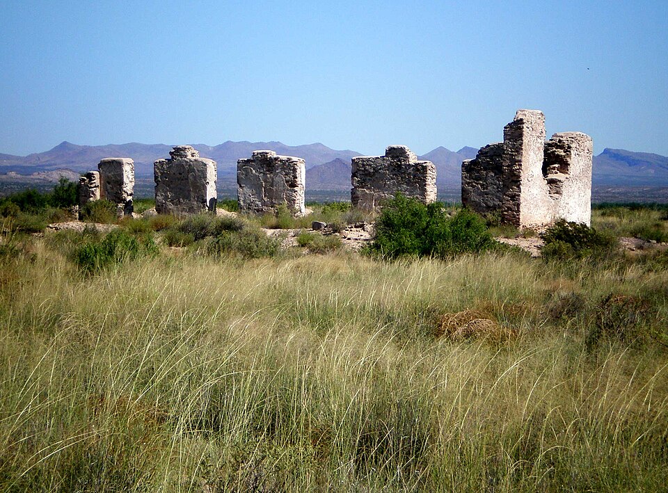
Photograph of Fort Craig
Photograph by Plazak, CC BY-SA 3.0. Via Wikimedia Commons.

Fort Craig

Listed on the National Register of Historic Places in 1970.

From the record

“Army fort located along El Camino Real de Tierra Adentro, near Elephant Butte Lake State Park and the Rio Grande in Socorro County, New Mexico.”

Wikipedia article Fort Craig, CC BY-SA 4.0.

One of 38 National Register listings published here for Socorro County · listed in 1970 · category: Site.

Sources: the Wikipedia article · the case file at the National Archives · the National Register database, National Park Service

The listing

  • Address. 37 mi. S of Socorro, Socorro, 87832
  • When was it listed? October 1970
  • Category. site
  • Census division. Socorro
  • National Register reference number. 70000414 - the number the National Park Service assigned this property when it was listed, and the key its nomination file is catalogued under at the National Archives.

Fires near this property

13 since 1993

Regional context, not property-specific evidence. The federal wildfire occurrence database lists 13 fires within 5 miles of Fort Craig between 1993 and 2020, burning about 10,747 acres in total. 5 started naturally. None was recorded as arson. Distance is straight-line from the map coordinates, so a fire counted here may appear on a neighbouring settlement's page as well.

Reported cause Fires
Missing data/not specified/undetermined6
Natural5
Recreation and ceremony1
Equipment and vehicle use1

The most recent of them, most recent first, with the day each was reported and the service that recorded it.

DateCause SizeReported by Name on the report
6 July 2014Naturalunder an acreSocorro Field OfficeJORNADA
5 July 1993Missing data/not specified/undeterminedunder an acreNew Mexico State Forestry DivisionFREEWAY
26 July 2015Missing data/not specified/undetermined685 acresSocorro Field OfficeFORT CRAIG
7 June 2011Equipment and vehicle useunder an acreNew Mexico State Forestry DivisionI-25 MM 118
7 June 1995Missing data/not specified/undeterminedunder an acreNew Mexico State Forestry DivisionMM117-25
6 June 2020Natural325 acresSocorro Field OfficeFORT CRAIG
3 June 2003Natural15 acresSocorro Field OfficeBLK MESA
26 June 2017Natural8,365 acresBosque del Apache National Wildlife RefugeTIFFANY

Every fire recorded in Socorro County

Mines and quarries near this property

1 within 5 miles

Regional context, not property-specific evidence. The federal mineral resources record lists 1 working within 5 miles of Fort Craig: 1 unknown. None of them still produces. What was taken out: Sand and Gravel, Construction. Distance is straight-line from the map coordinates, so a quarry counted here may appear on a neighbouring settlement's page as well.

Where SiteCommodity StatusRecorded
Materials PitsSand and Gravel, ConstructionUnknown

Every working recorded in Socorro County

Storms near this property

24 since 1996

Regional context, not property-specific evidence. The National Weather Service names Socorro, the town this property stands in, in 24 storm reports between 1996 and 2023: 13 hail, 5 flash flood, 3 thunderstorm wind, 1 heavy rain. No death or injury is recorded in these reports. Each account below is quoted exactly as the forecast office filed it, from the NOAA Storm Events Database, and each date opens the federal record of that event.

WhenEvent Place namedHarm What the report says
October 2004HailSocorro$40,000,000no account filed
September 1997Heavy RainSocorro$200,000no account filed
July 1999Flash FloodSocorro$150,000Heavy rain near Socorro filled arroyos with runoff during the late evening. Several levees along Arroyo Matanza failed as additional strong runoff from the Magdalena Mountains overwhelmed a 90 degree turn in the arroyo just south of Socorro. Water flooded nearly 800 acres of farmland washing away fresh cut alfalfa hay and covering about 300 acres in heavy mud. An adjacent railroad bed was also undercut least 5 times along 2 miles of track.
July 1997Thunderstorm WindSocorro$60,000A mobile home overturned and landed on a car, and power lines were downed as a brief, but strong storm moved over Socorro.
July 2013Thunderstorm WindSocorro$20,000The metal roof of the Socorro County annex building was partially peeled off and significantly damaged.
September 2013FloodSocorro$5,000Franklin Street flooded and closed due to high water. Other streets in western Socorro also flooded out from heavy rainfall.
July 1998Flash FloodSocorro$5,000Isolated heavy rain of near 1 inch an hour produced heavy street flooding in Socorro. Several small arroyos, filled with weeds and other debris overflowed and caused damage to several homes.
July 2010Thunderstorm WindSocorro$3,000Several tree branches larger than 2 inches in diameter were broken off of trees from wind gusts estimated around 60 mph. In addition, high winds knocked the roof off of an abandoned single wide trailer, which fell onto the roof a neighboring house on Blue Canyon Dr.
May 2023HailSocorro-The county emergency manager estimated quarter size hail in Socorro.
June 2020HailSocorro-A trained spotter reported quarter size hail with a severe thunderstorm that moved through Socorro.
May 2018HailSocorro-Penny size hail and heavy rain reported on the NM Tech campus.
July 2017LightningSocorro-A 93-year old woman died from a lightning caused fire at her home of 80 years. She died from smoke inhalation.
October 2015HailSocorro-One inch accumulation of pea to nickel size hail.
July 2006Flash FloodSocorro-Heavy street flooding was reported in Socorro and Sixmile Canyon just south of town filled 8 to 10 foot deep with roaring water during heavy rain.
August 2006Flash FloodSocorro-Heavy rain of 2 to 3 inches on the west water shed area of Water Canyon caused flash flooding that moved east to Interstate 25 at Escondida. Some road and irrigation ditch repairs were wiped out by this fresh flooding.
July 1999Flash FloodSocorro-Heavy rain continued to flood roads north of Socorro with at least 2 State Police vehicles trapped on high ground between flooded arroyos.
September 2023HailSocorro-no account filed
July 2015HailSocorro-no account filed
October 2015HailSocorro-no account filed
August 2008HailSocorro-no account filed
September 2006HailSocorro-no account filed
July 2002HailSocorro-no account filed
September 2002HailSocorro-no account filed
September 1996HailSocorro-no account filed

Every storm recorded in Socorro County

Newspapers printed here

2,484 digitised pages

3 papers published in this town, digitised by the Library of Congress and free to read: 593 issues, 2,484 pages. Every page is searchable, so a name or a street can be looked for directly in what the town printed about itself at the time.

NewspaperPublished
The Socorro Chieftain1902 to 1959
The Chieftain1890 to 1901
The Socorro Chieftain1884 to 1890

Map coverage status

No historic map-sheet match is published for this property yet. That does not mean no map exists. This record needs a coordinate-quality review before it can be joined to a sheet boundary. Browse the county's mapped places while that work is pending.

Sources for this property

National Archives recordThe nomination case file for reference 70000414 in Record Group 79.
Wikipedia articleCommunity-written account of this property, licensed CC BY-SA.
Socorro CountyAll 38 listed properties in this county.

Provenance

  • Listing record. National Park Service National Register of Historic Places, listed-properties dataset, current to 2026-05-22.
  • Map join. Address geocoded through the United States Census geocoder, then tested against the published boundary of every sheet in the USGS Historical Topographic Map Collection.
  • How this page is made. Listing fields come from federal records; map-sheet coverage is a labelled coordinate-to-boundary calculation, not a source-field claim.
  • Wildfire. Short, Karen C. 2022. Spatial wildfire occurrence data for the United States, 1992-2020 [FPA_FOD_20221014]. 6th Edition. Fort Collins, CO: Forest Service Research Data Archive. https://doi.org/10.2737/RDS-2013-0009.6 Collected with United States Government funding and usable without additional permissions or fees.
  • Mines and quarries. USGS Mineral Resources Data System (MRDS) https://mrdata.usgs.gov/mrds/ A work of the United States government, no copyright under 17 U.S.C. 105.
  • Storms. NOAA National Centers for Environmental Information, Storm Events Database https://www.ncei.noaa.gov/stormevents/ A work of the United States government, no copyright under 17 U.S.C. 105. Narratives are quoted verbatim from the National Weather Service report and are not edited or summarised.