
BlockBefore
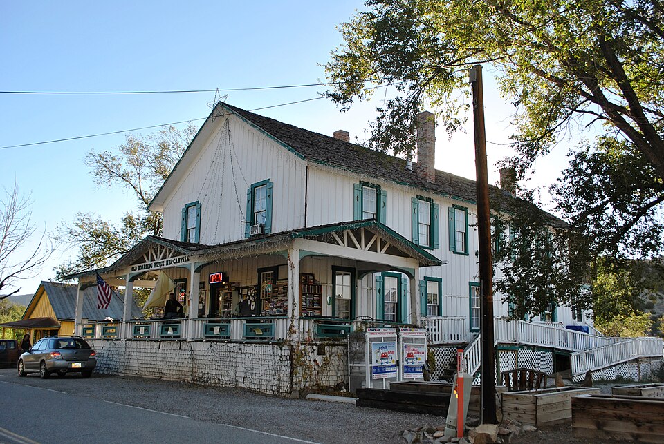
Photograph of Madrid Historic District
Photograph by Elisa.rolle, CC BY-SA 4.0. Via Wikimedia Commons.

Madrid Historic District

Built in 1892. Listed on the National Register of Historic Places in 1977.

From the record

“The Madrid Historic District is a national historic district that designates the majority of the buildings in the 19th-century mining town of Madrid, New Mexico.”

Wikipedia article Madrid Historic District, CC BY-SA 4.0.

One of 79 National Register listings published here for Santa Fe County · listed in 1977 · category: District · built in 1892.

Sources: the Wikipedia article · the case file at the National Archives · the National Register database, National Park Service

The listing

  • Address. 25 mi. SW of Santa Fe on NM 14, Madrid, 87010
  • When was it listed? November 1977
  • Category. district
  • Census division. Santa Fe South
  • When was it built? 1892
  • National Register reference number. 77000928 - the number the National Park Service assigned this property when it was listed, and the key its nomination file is catalogued under at the National Archives.

Fires near this property

17 since 1994

Regional context, not property-specific evidence. The federal wildfire occurrence database lists 17 fires within 5 miles of Madrid Historic District between 1994 and 2019, burning about 13 acres in total. 8 started naturally. 1 was recorded as arson. Distance is straight-line from the map coordinates, so a fire counted here may appear on a neighbouring settlement's page as well.

Reported cause Fires
Natural8
Missing data/not specified/undetermined7
Other causes1
Arson/incendiarism1

The most recent of them, most recent first, with the day each was reported and the service that recorded it.

DateCause SizeReported by Name on the report
10 August 1995Missing data/not specified/undeterminedunder an acreNew Mexico State Forestry DivisionORTIZ
5 July 2009Naturalunder an acreBernalillo DistrictCHRISTMAS
26 July 1994Natural3.0 acresCarson National Forestnot named
23 July 2005Naturalunder an acreNew Mexico State Forestry DivisionCEDAR MTN
17 July 2019Naturalunder an acreBernalillo District20-60200086N
12 July 2004Naturalunder an acreNew Mexico State Forestry DivisionPLACER
11 July 2002Naturalunder an acreNew Mexico State Forestry DivisionORTIZ MINE
7 June 2005Missing data/not specified/undeterminedunder an acreNew Mexico State Forestry DivisionMADRID

Every fire recorded in Santa Fe County

Mines and quarries near this property

10 of 16 shown

Regional context, not property-specific evidence. The federal mineral resources record lists 16 workings within 5 miles of Madrid Historic District: 9 past producers, 2 producers, 2 unknowns, 2 occurrences. 3 still produce. What was taken out: Gold, Silver, Zinc, Silver, Lead, Zinc, Lead. Distance is straight-line from the map coordinates, so a quarry counted here may appear on a neighbouring settlement's page as well.

Where SiteCommodity StatusRecorded
Cash EntryZinc, Silver, Lead, Copper, GoldOccurrence
Cash Entry MineLead, Zinc, Silver, Gold, CopperOccurrence1880, 1915
Central MineZincPast Producer
Cerrilos MineClayProducerSedimentary
Cunningham Hill MineGold, Silver, Tungsten, Copper, Lead, MolybdenumProducer1828, 1945
Franklin MineLead, Zinc, Silver, GoldPast Producer1885, 1909, 1946
Franklin MineZinc, Lead, CadmiumPast Producer
Grand Central MineLead, Zinc, Gold, SilverPast Producer1879, 1885, 1952
Live OakSilver, Copper, GoldUnknown
Materials PitSand and Gravel, ConstructionUnknown

Every working recorded in Santa Fe County

Storms near this property

15 since 2006

Regional context, not property-specific evidence. The National Weather Service names Madrid, the town this property stands in, in 15 storm reports between 2006 and 2024: 6 hail, 6 flash flood, 1 thunderstorm wind, 1 flood. No death or injury is recorded in these reports. Each account below is quoted exactly as the forecast office filed it, from the NOAA Storm Events Database, and each date opens the federal record of that event.

WhenEvent Place namedHarm What the report says
September 2013Flash FloodMadrid$500,000State EOC Situation Report #12 indicated 10 businesses were flooded in Madrid. Most significant damage done to Mine Shaft Tavern and nearby museums. Mud and coal damage to most structures. Gold Mine Road, Rogersville Road, and Puebla Road 76 were cleared of flooding debris.
July 2020Flash FloodMadrid$100,000A sudden torrent of rainfall filled several arroyos around Madrid and Cerrillos. Flood damage was reported to low water crossings, culverts, and driveways. Damage amounts are a very rough estimate for repairs to several roadways and culverts.
August 2019Flash FloodMadrid$100,000One to two inches of rainfall in less than an hour around Cerrillos produced flash flooding along Galisteo Creek and nearby rural areas. Galisteo Creek at Galisteo Dam rose 5.5 feet in one hour. Many dirt roads were flooded and washed out with rocks, mud, and debris. A dramatic video along Goldmine Road south of Cerrillos looked like a tropical storm was impacting the area. Damage amounts are estimated for road damage in the area.
July 2021Flash FloodMadrid$10,000A National Weather Service employee in Madrid measured 1.85 inches of rain from a thunderstorm producing heavy rain. This led to flash flooding along New Mexico State Road 14 in Madrid and south of Los Cerillos along with mud and other debris washed onto the roadway. Damages are a rough estimate.
July 2015Flash FloodMadrid$5,000Photos showed water rushing over Red Rock Road near Madrid and making it impassable. The report indicated that the depth of the water over the road peaked at 3 feet. It took about an hour for the water to subside enough before safely crossing.
June 2024HailMadrid$2,000Trained spotters in Madrid and Los Cerillos reported dime to half dollar size hail from a severe thunderstorm that dented vehicles and broke house windows. Hail accumulations of up to 3 inches deep covered the ground. Damage is an estimate.
July 2013Flash FloodMadrid$1,000A major mudslide off the hill behind property ended up a couple feet deep on the deck and patio. Unpaved driveway completely destroyed by flood waters. The arroyo that crossed the property along NM 14 was at least 40 feet wide and 10 feet deep.
May 2021HailMadrid-A trained spotter measured one inch hail from a severe thunderstorm near Los Cerrillos. The severe thunderstorms also produced deep hail accumulations along Interstate 25 with multiple spotters reporting hail depths ranging from one to three inches.
July 2021Tornado (EF0)Madrid-A trained spotter reported a brief landspout southeast of Madrid. The landspout only lasted about a minute, and no damage was reported as it occurred over open country.
March 2019HailMadrid-Hail up to the size of pennies reported a few miles north of Madrid.
June 2019HailMadrid-Quarter size hail near Los Cerrillos.
June 2019HailMadrid-Quarter size hail reported near Madrid.
July 2015FloodMadrid-The Galisteo Creek below the Galisteo Dam reached flood stage of 9 feet for about 2 hours, cresting at 9.18 feet.
August 2012Thunderstorm WindMadrid-A slow-moving thunderstorm produced a major downpour and wind gusts estimated near 60 mph. Reduced visibilities in blowing dust were also observed.
July 2006HailMadrid-no account filed

Every storm recorded in Santa Fe County

Map coverage status

No historic map-sheet match is published for this property yet. That does not mean no map exists. This record needs a coordinate-quality review before it can be joined to a sheet boundary. Browse the county's mapped places while that work is pending.

Sources for this property

National Archives recordThe nomination case file for reference 77000928 in Record Group 79.
Wikipedia articleCommunity-written account of this property, licensed CC BY-SA.
Santa Fe CountyAll 79 listed properties in this county.

Provenance

  • Listing record. National Park Service National Register of Historic Places, listed-properties dataset, current to 2026-05-22.
  • Map join. Address geocoded through the United States Census geocoder, then tested against the published boundary of every sheet in the USGS Historical Topographic Map Collection.
  • How this page is made. Listing fields come from federal records; map-sheet coverage is a labelled coordinate-to-boundary calculation, not a source-field claim.
  • Wildfire. Short, Karen C. 2022. Spatial wildfire occurrence data for the United States, 1992-2020 [FPA_FOD_20221014]. 6th Edition. Fort Collins, CO: Forest Service Research Data Archive. https://doi.org/10.2737/RDS-2013-0009.6 Collected with United States Government funding and usable without additional permissions or fees.
  • Mines and quarries. USGS Mineral Resources Data System (MRDS) https://mrdata.usgs.gov/mrds/ A work of the United States government, no copyright under 17 U.S.C. 105.
  • Storms. NOAA National Centers for Environmental Information, Storm Events Database https://www.ncei.noaa.gov/stormevents/ A work of the United States government, no copyright under 17 U.S.C. 105. Narratives are quoted verbatim from the National Weather Service report and are not edited or summarised.