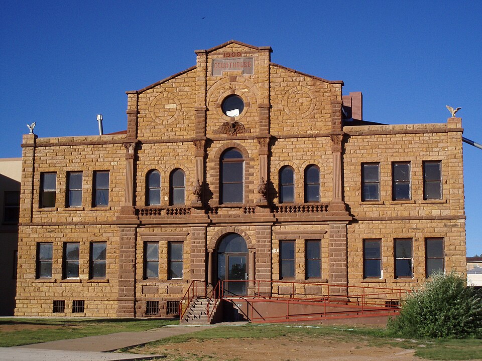
Built in 1909 (Richardsonian Romanesque). Listed on the National Register of Historic Places in 1987.
From the record
“The Guadalupe County Courthouse in Santa Rosa, in Santa Rosa, New Mexico, is a former courthouse of Guadalupe County which was built in Richardsonian Romanesque style. It was built in 1909 and was listed on the National Register of Historic Places in 1987.”
Wikipedia article Guadalupe County Courthouse in Santa Rosa, CC BY-SA 4.0.
One of 6 National Register listings published here for Guadalupe County · listed in 1987 · category: Building · built in 1909, Richardsonian Romanesque.
Also known as. County Courthouses of New Mexico TR
Census division. Santa Rosa
When was it built? 1909
Architectural style. Richardsonian Romanesque
National Register reference number.87000890- the number the National Park Service assigned this property when it was listed, and the key its nomination file is catalogued under at the National Archives.
Fires near this property
29 since 1994
Regional context, not property-specific
evidence. The
federal wildfire occurrence database
lists 29 fires within 5 miles of Guadalupe County Courthouse in Santa Rosa
between 1994 and 2020, burning about 4,228 acres in total. 3 started naturally. None was recorded as arson.
Distance is straight-line from the map coordinates, so a fire counted
here may appear on a neighbouring settlement's page as well.
Reported cause
Fires
Missing data/not specified/undetermined
13
Debris and open burning
5
Smoking
3
Railroad operations and maintenance
3
Natural
3
Power generation/transmission/distribution
1
Misuse of fire by a minor
1
The most recent of
them, most recent first, with the day each was reported and the service
that recorded it.
Regional context, not property-specific
evidence. The federal mineral resources record lists
12 workings within 5 miles of Guadalupe County Courthouse in Santa Rosa: 9 unknowns, 2 past producers, 1 occurrence.
None of them still produces. What was taken out: Sand and Gravel, Construction, Uranium. Distance is straight-line from the
map coordinates, so a quarry counted here may appear on a neighbouring
settlement's page as well.
Regional context, not property-specific
evidence. The National Weather Service names
Santa Rosa, the town this property stands in, in 60 storm reports between 1996 and 2025: 40 hail, 7 flash flood, 6 thunderstorm wind, 3 heavy rain.
No death or injury is recorded in these reports. Each account below is quoted exactly as the forecast office
filed it, from the NOAA Storm Events Database, and each date
opens the federal record of that event.
State police had to pull 3 vehicles out of mud on Highway 91 created by the heavy rains. Reilly Road between Highway 91 and Blue Hole was later closed as it was covered by flash flood water. These waters also went into the nearby senior center.
Nickel to golfball sized hail pounded the Santa Rosa area resulting in major damage. Partial roof collapses and broken skylights were common throughout the central and western portions of the community. Smaller hail accumulated to depths of up to two feet in areas. Snow plows were required to clear roads. Many local residents and motorists described the scene as snow in July.
State EOC Situation Report #2 reported Blue Hole Road closed due to flooding. The Santa Rosa golf course and a pump house flooded with extensive damage. Entire golf course was under water. Flooding was also reported near the KSRR transmitter.
Two lightning bolts just a few seconds apart made direct hits to the TravelCenters of America just after midnight on July 16th. The strikes caused a power surge which fried circuitry and temporarily knocked 17 fuel pumps out of service. The pumps were not restored to service until the late afternoon during that day as electricians worked to repair the damage caused by the strikes.
A semi trailer was blown over from thunderstorm winds 6 miles west of Santa Rosa. The airport in Santa Rosa reported a peak wind gust up to 60 mph around the time of the incident. Damage amounts are estimated for an overturned semi trailer with unknown contents.
A SKYWARN Spotter relayed a report of automobile damage due to large hail just north of Santa Rosa. Hail sizes in this area ranged from nickel to golfball sized.
Heavy rain from severe thunderstorms resulted in five inches of water on 8th Street near Eddy Avenue and 6 inches of water on Park Lake Drive in Santa Rosa, NM.
Very heavy rainfall overnight dumped 3.20 inches at Santa Rosa. Minor flooding was observred around town and within the El Rito Creek and Pecos River drainages. Areas downstream toward Puerto de Luna saw flooding in the same area where damage occurred to Power Dam in 2013.
Widespead heavy rainfall and flooding around Santa Rosa led to a near record crest on the Pecos River at Puerto de Luna. The crest peaked at 35,800 cfs at 615pm on the 11th, which is the 2nd highest crest ever observed going back to 1942. The gauge was above flood stage for several hours.
Three people were killed (indirect) and two others injured (indirect) when a car traveling west on Interstate 40 near Santa Rosa slid into on-coming traffic in a rain and hail storm. Small hail reportedly covered the roadway. Additional information on the victims was not available.
Strong and slow moving thunderstorms which produced estimated rains of 4-6 inches in several hours across rural western and central Guadalupe County moved into Santa Rosa with widespread and heavy street flooding.
No historic map-sheet match is published
for this property yet. That does not mean no map exists. This record needs
a coordinate-quality review before it can be joined to a sheet boundary.
Browse the county's mapped places while that work is
pending.
Listed places nearby
3 within 8 miles
Other National Register properties close
enough to walk or drive between, ordered by distance from this one. Both
positions come from the same geocoding pass that matched these properties
to their map sheets.
Listing record. National Park Service National Register of Historic Places, listed-properties dataset, current to 2026-05-22.
Map join. Address geocoded through the United States Census geocoder, then tested against the published boundary of every sheet in the USGS Historical Topographic Map Collection.
How this page is made. Listing fields come from federal records; map-sheet coverage is a labelled coordinate-to-boundary calculation, not a source-field claim.
Wildfire. Short, Karen C. 2022. Spatial wildfire occurrence data for the United States, 1992-2020 [FPA_FOD_20221014]. 6th Edition. Fort Collins, CO: Forest Service Research Data Archive. https://doi.org/10.2737/RDS-2013-0009.6 Collected with United States Government funding and usable without additional permissions or fees.
Mines and quarries. USGS Mineral Resources Data System (MRDS) https://mrdata.usgs.gov/mrds/ A work of the United States government, no copyright under 17 U.S.C. 105.
Storms. NOAA National Centers for Environmental Information, Storm Events Database https://www.ncei.noaa.gov/stormevents/ A work of the United States government, no copyright under 17 U.S.C. 105. Narratives are quoted verbatim from the National Weather Service report and are not edited or summarised.
 Block