 Block
From the record
One of 7 National Register listings published here for Catron County · listed in 1987 · category: District.
Sources: the case file at the National Archives · the National Register database, National Park Service
Listed on the National Register of Historic Places in 1987.
One of 7 National Register listings published here for Catron County · listed in 1987 · category: District.
Sources: the case file at the National Archives · the National Register database, National Park Service
Regional context, not property-specific evidence. The federal wildfire occurrence database lists 57 fires within 5 miles of Socorro Mines Mining Company Mill, Fannie Hill between 1992 and 2019, burning about 411 acres in total. 50 started naturally. 1 was recorded as arson. Distance is straight-line from the map coordinates, so a fire counted here may appear on a neighbouring settlement's page as well.
| Reported cause | Fires |
|---|---|
| Natural | 50 |
| Recreation and ceremony | 4 |
| Other causes | 1 |
| Arson/incendiarism | 1 |
| Missing data/not specified/undetermined | 1 |
The most recent of them, most recent first, with the day each was reported and the service that recorded it.
| Date | Cause | Size | Reported by | Name on the report |
|---|---|---|---|---|
| 13 September 1995 | Natural | under an acre | Gila National Forest | WOPPER |
| 11 September 1995 | Natural | 1.0 acres | Gila National Forest | TOWNSITE |
| 7 August 1994 | Natural | under an acre | Gila National Forest | not named |
| 29 August 2007 | Natural | under an acre | Gila National Forest | SILVER |
| 2 August 1993 | Natural | under an acre | Gila National Forest | not named |
| 2 August 1993 | Natural | under an acre | Gila National Forest | not named |
| 15 August 1994 | Natural | under an acre | Gila National Forest | not named |
| 13 August 1998 | Natural | under an acre | Gila National Forest | HOGAN |
Regional context, not property-specific evidence. The federal mineral resources record lists 96 workings within 5 miles of Socorro Mines Mining Company Mill, Fannie Hill: 43 unknowns, 20 past producers, 15 occurrences, 9 prospects. 9 still produce. What was taken out: Silver, Gold, Silver, Copper, Gold. Distance is straight-line from the map coordinates, so a quarry counted here may appear on a neighbouring settlement's page as well.
| Where | Site | Commodity | Status | Recorded |
|---|---|---|---|---|
| Baby Mine | Uranium, Vanadium, Fluorine-Fluorite | Past Producer | 1956 | |
| Bearup Mine | Gold, Silver, Zinc, Copper | Past Producer | 1969 | |
| Cooney Mine | Silver, Gold, Copper | Past Producer | 1875, 1885, 1911 | |
| Cooney Mine | Silver, Copper, Gold | Past Producer | ||
| Little Fanney Mine | Gold, Silver, Copper, Lead | Producer | 1895, 1934 | |
| Mogollon District | Gold, Silver, Copper, Lead, Zinc, Iron | Producer | 1875, 1879 | |
| N Slope Whitewater Canyon Prospect | Manganese, Tungsten | Occurrence | ||
| Pacific Mine | Silver, Gold, Copper | Past Producer | ||
| The Lime Kiln | Calcium | Unknown | ||
| Trilby Mine | Gold, Silver, Fluorine-Fluorite | Past Producer | Argentite, Gold |
Regional context, not property-specific evidence. The National Weather Service names Mogollon, the town this property stands in, in 7 storm reports between 2012 and 2016: 4 flash flood, 1 flood, 1 hail, 1 heavy rain. The reports record 1 death. Each account below is quoted exactly as the forecast office filed it, from the NOAA Storm Events Database, and each date opens the federal record of that event.
| When | Event | Place named | Harm | What the report says |
|---|---|---|---|---|
| September 2013 | Flash Flood | Mogollon | 1 killed, $1,500,000 | Portions of Bursum Road to the community of Mogollon was completely destroyed by flash flooding. All homes and business along the creek in Mogollon were flooded and damaged, many severely. Several vehicles were carried away, destroyed, and left in the bottom of the creek bed. The USFS delivered MREs, water, and sanitary supplies to Mogollon by foot and with 2 mules. An 83-year old Arizona man was found dead 8 miles downstream from where his vehicle was located and destroyed in Mineral Creek. |
| August 2012 | Flash Flood | Mogollon | $10,000 | Eight feet flow of water within Silver Creek washed debris over Highway 159 and surrounding bridges and yards. |
| September 2016 | Heavy Rain | Mogollon | - | The Hummingbird Saddle rain gage reported 3.93 inches of rainfall from the remnants of Hurricane Newton. No flooding was observed. |
| July 2013 | Flood | Mogollon | - | Morning rainfall that ranged from 1 to nearly 3 in some areas around the burn scar caused heavy flows in creeks in the area which in turn deposited debris on roads. Roads were closed until the Department of Transportation could clear them. |
| September 2013 | Flash Flood | Mogollon | - | Bursum Road closed from near Mogollon east about 10 miles due to debris and flooding over the roadway. |
| July 2013 | Flash Flood | Mogollon | - | Bursum Rd - NM 159 was closed due to flooding and burn scar debris from mile marker 2-25. Per reports, Silver Creek flooded Mogollon and blew out Bursum Rd. in several locations near Mogollon. Whitewater Creek also flooded and brought down a significant amount of ash. The Catwalk was closed due to flooding as well. Rainfall amounts ranging from 0.50 to 1.40 inches were recorded from RAWS and HADS sites in the area. |
| October 2015 | Hail | Mogollon | - | no account filed |
No historic map-sheet match is published for this property yet. That does not mean no map exists. This record needs a coordinate-quality review before it can be joined to a sheet boundary. Browse the county's mapped places while that work is pending.
Other National Register properties close enough to walk or drive between, ordered by distance from this one. Both positions come from the same geocoding pass that matched these properties to their map sheets.
| Photograph | Property | Distance | Listed |
|---|---|---|---|
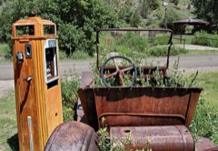 | Mogollon Historic District | 0.6 miles | 1987 |
| National Archives record | The nomination case file for reference 87001567 in Record Group 79. |
| Catron County | All 7 listed properties in this county. |