 Block
From the record
One of 13 National Register listings published here for Quay County · listed in 1994 · category: Structure.
Sources: the case file at the National Archives · the National Register database, National Park Service
Listed on the National Register of Historic Places in 1994.
One of 13 National Register listings published here for Quay County · listed in 1994 · category: Structure.
Sources: the case file at the National Archives · the National Register database, National Park Service
Regional context, not property-specific evidence. The federal wildfire occurrence database lists 10 fires within 5 miles of Locally Maintained Route 66-Glenrio to San Jon between 1998 and 2020, burning about 3,282 acres in total. 3 started naturally. None was recorded as arson. Distance is straight-line from the map coordinates, so a fire counted here may appear on a neighbouring settlement's page as well.
| Reported cause | Fires |
|---|---|
| Equipment and vehicle use | 4 |
| Natural | 3 |
| Missing data/not specified/undetermined | 2 |
| Debris and open burning | 1 |
The most recent of them, most recent first, with the day each was reported and the service that recorded it.
| Date | Cause | Size | Reported by | Name on the report |
|---|---|---|---|---|
| 3 September 2000 | Natural | 200 acres | New Mexico State Forestry Division | GLENRIO |
| 16 August 2019 | Natural | 42 acres | Las Vegas District | 20-40180184X |
| 13 August 2010 | Natural | 101 acres | Las Vegas District | FOOTE |
| 7 July 1998 | Missing data/not specified/undetermined | 640 acres | New Mexico State Forestry Division | JORDI |
| 5 June 2011 | Equipment and vehicle use | 2.0 acres | New Mexico State Forestry Division | BLOWOUT |
| 29 June 2020 | Missing data/not specified/undetermined | 780 acres | Las Vegas District | ODEN |
| 23 June 2011 | Equipment and vehicle use | 36 acres | New Mexico State Forestry Division | CAIN |
| 15 May 2006 | Equipment and vehicle use | 30 acres | New Mexico State Forestry Division | not named |
Regional context, not property-specific evidence. The federal mineral resources record lists 1 working within 5 miles of Locally Maintained Route 66-Glenrio to San Jon: 1 unknown. None of them still produces. What was taken out: Sand and Gravel, Construction. Distance is straight-line from the map coordinates, so a quarry counted here may appear on a neighbouring settlement's page as well.
| Where | Site | Commodity | Status | Recorded |
|---|---|---|---|---|
| Unnamed Pit | Sand and Gravel, Construction | Unknown |
Regional context, not property-specific evidence. The National Weather Service names San Jon, the town this property stands in, in 66 storm reports between 1994 and 2025: 42 hail, 13 thunderstorm wind, 4 tornado, 3 funnel cloud. No death or injury is recorded in these reports. Each account below is quoted exactly as the forecast office filed it, from the NOAA Storm Events Database, and each date opens the federal record of that event.
| When | Event | Place named | Harm | What the report says |
|---|---|---|---|---|
| June 1994 | Tornado (F0) | San Jon | $50,000 | no account filed |
| May 2021 | Thunderstorm Wind | San Jon | $10,000 | A microburst with estimated 70 to 90 mph winds from a severe thunderstorm caused significant damage in and around Grady as well as in far southern Quay County. In southern Quay County, a National Weather Service damage survey team estimated 70 mph winds associated with the microburst destroyed a carport. The carport along with a downed TV antenna was carried 200 yards away from their original location. A storage shed that was attached to the carport was also tipped over. Additionally, several large trees limbs were downed. Damages are estimated for the loss and damage to the carport, TV antenna, storage shed, and tree limbs. |
| July 2009 | Hail | San Jon | $2,500 | no account filed |
| June 2010 | Thunderstorm Wind | San Jon | $1,000 | Multiple large tree branches were knocked down. A 12 inch diameter cottonwood tree was reduced to less than half its original height. |
| July 1998 | Flash Flood | San Jon | $1,000 | no account filed |
| April 2025 | Hail | San Jon | - | A trained spotter 1 mile southwest of Wheatland observed quarter size hail from a severe thunderstorm. |
| June 2025 | Thunderstorm Wind | San Jon | - | The public reported a severe thunderstorm wind gust of 60 mph near San Jon, NM. |
| May 2024 | Hail | San Jon | - | A trained spotter near Wheatland reported lots of quarter size hail and wind gusts of up to 50 mph from a severe thunderstorm. |
| May 2024 | Hail | San Jon | - | A severe thunderstorm produced quarter size hail a few miles north of Wheatland. |
| May 2023 | Hail | San Jon | - | One inch hail was reported just west of San Jon, NM. |
| May 2023 | Hail | San Jon | - | One inch hail reported south of San Jon. Hail stones likely peaked larger than this based on surrounding 2 inch reports during this timeframe. |
| May 2023 | Hail | San Jon | - | A trained spotter estimated a few nickel size hail stones fell at San Jon. Strong wind gusts also were ripping through their trees, but no damage was reported. |
| May 2023 | Hail | San Jon | - | Hail reports ranging in size from dimes to quarters in San Jon. |
| May 2023 | Hail | San Jon | - | Two inch hail a few miles west of San Jon along I-40. |
| May 2023 | Thunderstorm Wind | San Jon | - | A storm chaser reported an estimated thunderstorm wind gust of 70 mph. |
| May 2019 | Hail | San Jon | - | Quarter size hail reported near Wheatland. |
| August 2018 | Hail | San Jon | - | Hail up to the size of quarters near Wheatland. |
| August 2018 | Thunderstorm Wind | San Jon | - | Peak wind gusts up to 60 mph downed a few large tree limbs in Wheatland. |
| May 2018 | Hail | San Jon | - | Penny size hail at Giddy Up Ranch. |
| October 2017 | Flash Flood | San Jon | - | Rock slides, mud, and debris covering portions of state highway 469 between San Jon and Grady. Road was closed for several hours after causative event. |
| May 2017 | Thunderstorm Wind | San Jon | - | Thunderstorm wind gusts estimated between 60 and 70 mph with dime size hail. |
| May 2016 | Hail | San Jon | - | Quarter size hail along Interstate 40 at mile marker 359 near San Jon. |
| June 2015 | Hail | San Jon | - | Trained spotter reported penny size hail. |
| June 2015 | Hail | San Jon | - | Trained spotter reported nickel size hail. |
| July 2015 | Thunderstorm Wind | San Jon | - | Report of 65 mph outflow winds with torrential rainfall in San Jon. |
| July 2014 | Heavy Rain | San Jon | - | State police dispatcher reported that she received 3.05 inches of rain at her residence during the overnight hours. |
| May 2014 | Hail | San Jon | - | Numerous reports of pea to nickel sized hail around San Jon. |
| July 2011 | Hail | San Jon | - | Quarter size hail was reported along I-40. |
| July 2009 | Thunderstorm Wind | San Jon | - | A cooperative observer reported that several tree limbs were downed around town including a large branch from a Cottonwood tree. |
| June 2004 | Thunderstorm Wind | San Jon | - | Semi-truck blown over on Interstate 40. |
| July 2000 | Hail | San Jon | - | Heavy rain, large hail and several funnel clouds were reported from San Jon. |
| May 1999 | Funnel Cloud | San Jon | - | Brief funnel cloud reported by deputies. |
| August 1998 | Tornado (F0) | San Jon | - | A brief tornado touchdown was noted by several observers. |
| July 1994 | Hail | San Jon | - | The San Jon Fire Department reported a brief tornado and nickel-size hail just north of San Jon. Strong winds estimated at 60 mph and nickel-size hail were reported at the San Jon Port of Entry. |
| July 1994 | Tornado (F0) | San Jon | - | The San Jon Fire Department reported a brief tornado and nickel-size hail just north of San Jon. Strong winds estimated at 60 mph and nickel-size hail were reported at the San Jon Port of Entry. |
| July 1994 | Hail | San Jon | - | The San Jon Fire Department reported a brief tornado and nickel-size hail just north of San Jon. Strong winds estimated at 60 mph and nickel-size hail were reported at the San Jon Port of Entry. |
| July 1994 | Thunderstorm Wind | San Jon | - | The San Jon Fire Department reported a brief tornado and nickel-size hail just north of San Jon. Strong winds estimated at 60 mph and nickel-size hail were reported at the San Jon Port of Entry. |
| May 2023 | Hail | San Jon | - | no account filed |
| May 2023 | Hail | San Jon | - | no account filed |
| May 2023 | Hail | San Jon | - | no account filed |
| October 2015 | Hail | San Jon | - | no account filed |
| June 2014 | Hail | San Jon | - | no account filed |
| May 2014 | Hail | San Jon | - | no account filed |
| May 2010 | Hail | San Jon | - | no account filed |
| June 2008 | Hail | San Jon | - | no account filed |
| May 2005 | Hail | San Jon | - | no account filed |
| June 2005 | Hail | San Jon | - | no account filed |
| June 2005 | Hail | San Jon | - | no account filed |
| June 2004 | Hail | San Jon | - | no account filed |
| July 2004 | Hail | San Jon | - | no account filed |
| August 2004 | Hail | San Jon | - | no account filed |
| August 2004 | Tornado (F0) | San Jon | - | no account filed |
| August 2004 | Flash Flood | San Jon | - | no account filed |
| August 2004 | Thunderstorm Wind | San Jon | - | no account filed |
| June 2003 | Hail | San Jon | - | no account filed |
| June 2003 | Thunderstorm Wind | San Jon | - | no account filed |
| June 2003 | Hail | San Jon | - | no account filed |
| May 2002 | Hail | San Jon | - | no account filed |
| July 2002 | Hail | San Jon | - | no account filed |
| July 2002 | Hail | San Jon | - | no account filed |
No historic map-sheet match is published for this property yet. That does not mean no map exists. This record needs a coordinate-quality review before it can be joined to a sheet boundary. Browse the county's mapped places while that work is pending.
Other National Register properties close enough to walk or drive between, ordered by distance from this one. Both positions come from the same geocoding pass that matched these properties to their map sheets.
| Photograph | Property | Distance | Listed |
|---|---|---|---|
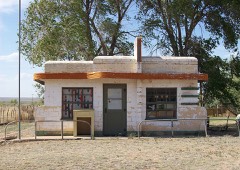 | Glenrio Historic District | 7.0 miles | 2007 |
| National Archives record | The nomination case file for reference 93001207 in Record Group 79. |
| Quay County | All 13 listed properties in this county. |