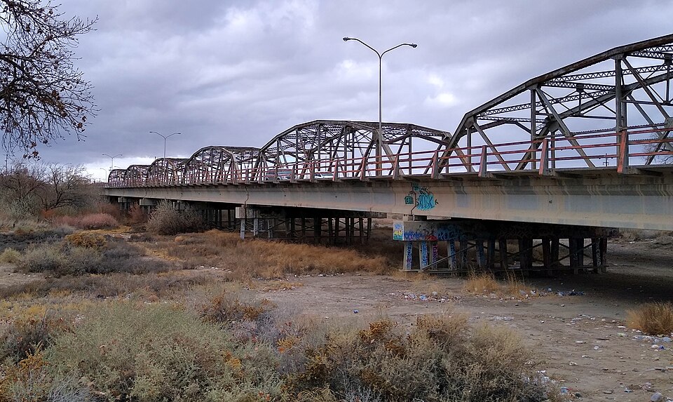
Built in 1937. Listed on the National Register of Historic Places in 1997.
From the record
“The San Juan River Bridge at Shiprock, in Shiprock, New Mexico, is a Parker through truss bridge built in 1937. It was listed on the National Register of Historic Places in 1997.”
Wikipedia article San Juan River Bridge at Shiprock, CC BY-SA 4.0.
One of 21 National Register listings published here for San Juan County · listed in 1997 · category: Structure · built in 1937.
Also known as. Historic Highway Bridges of New Mexico MPS
Census division. Shiprock-Sanostee
When was it built? 1937
National Register reference number.97000740- the number the National Park Service assigned this property when it was listed, and the key its nomination file is catalogued under at the National Archives.
Fires near this property
300 since 2000
Regional context, not property-specific
evidence. The
federal wildfire occurrence database
lists 300 fires within 5 miles of San Juan River Bridge at Shiprock
between 2000 and 2020, burning about 2,270 acres in total. 3 started naturally. 64 were recorded as arson.
Distance is straight-line from the map coordinates, so a fire counted
here may appear on a neighbouring settlement's page as well.
Reported cause
Fires
Debris and open burning
187
Arson/incendiarism
64
Missing data/not specified/undetermined
19
Equipment and vehicle use
9
Misuse of fire by a minor
6
Fireworks
4
Other causes
3
Natural
3
Smoking
2
Power generation/transmission/distribution
2
Recreation and ceremony
1
The most recent of
them, most recent first, with the day each was reported and the service
that recorded it.
Regional context, not property-specific
evidence. The federal mineral resources record lists
7 workings within 5 miles of San Juan River Bridge at Shiprock: 5 unknowns, 1 past producer, 1 producer.
1 still produces. What was taken out: Sand and Gravel, Construction, Uranium, Vanadium. Distance is straight-line from the
map coordinates, so a quarry counted here may appear on a neighbouring
settlement's page as well.
Regional context, not property-specific
evidence. The National Weather Service names
Shiprock, the town this property stands in, in 8 storm reports between 1999 and 2024: 4 flash flood, 2 heavy rain, 1 thunderstorm wind, 1 tornado.
The reports record 1 death and 4 injuries. Each account below is quoted exactly as the forecast office
filed it, from the NOAA Storm Events Database, and each date
opens the federal record of that event.
Serious flash flooding developed on Salt Creek Wash and created major damage to a community near Mesa Farm Road. Three to four homes were severely damaged and one home was destroyed. Several vehicles, motorcycles, recreational vehicles washed into creek and destroyed. Water rescues occurred from roof tops and amazingly no one was killed.
Heavy runoff within the Baker Arroyo jumped out and flooded west and south, impacting U.S. Highway 64, Christ the King Catholic Church, the Central Consolidated School District and the Chat and Chew restaurant. At least two homes were destroyed or made uninhabitable. Damage cost is an estimate.
Heavy runoff within the Salt Creek Wash overtopped a bridge along Farm Road or B.I.A. 364 and nearby homes. Vegetation overgrowth exacerbated these flood waters. Yellow Arroyo also flooded out over property, homes and nearby roadways from the same round of thunderstorms. Damage cost is an estimate.
The main building of Shiprock High School suffered a roof collapse during a storm with heavy rain and gusty winds. A 20-foot section of collapsed roof severed a 4 inch fire-sprinkler water pipe which then caused flooding of 12-15 classrooms. Storm drains along Highway 64 clogged and produced some road and street flooding.
A mobile home was overturned just south of U.S. 64 in Shiprock. The trailer had just moved to this location one month prior, and was not yet anchored down nor hooked up to any utilities. It sat atop it's wheels on one end and concrete blocks on another. There was no mobile home skirt around the trailer to prevent wind from going underneath. It appeared that the trailer rolled off the concrete blocks onto its side, and then again onto its roof. Two people were inside, but escaped without any major injuries.
Tropical funnel cloud touched ground for a couple minutes near Shiprock. Location and time determined from radar imagery and photos sent from print media and a NWS family relative. No damage reported.
No historic map-sheet match is published
for this property yet. That does not mean no map exists. This record needs
a coordinate-quality review before it can be joined to a sheet boundary.
Browse the county's mapped places while that work is
pending.
Listing record. National Park Service National Register of Historic Places, listed-properties dataset, current to 2026-05-22.
Map join. Address geocoded through the United States Census geocoder, then tested against the published boundary of every sheet in the USGS Historical Topographic Map Collection.
How this page is made. Listing fields come from federal records; map-sheet coverage is a labelled coordinate-to-boundary calculation, not a source-field claim.
Wildfire. Short, Karen C. 2022. Spatial wildfire occurrence data for the United States, 1992-2020 [FPA_FOD_20221014]. 6th Edition. Fort Collins, CO: Forest Service Research Data Archive. https://doi.org/10.2737/RDS-2013-0009.6 Collected with United States Government funding and usable without additional permissions or fees.
Mines and quarries. USGS Mineral Resources Data System (MRDS) https://mrdata.usgs.gov/mrds/ A work of the United States government, no copyright under 17 U.S.C. 105.
Storms. NOAA National Centers for Environmental Information, Storm Events Database https://www.ncei.noaa.gov/stormevents/ A work of the United States government, no copyright under 17 U.S.C. 105. Narratives are quoted verbatim from the National Weather Service report and are not edited or summarised.
 Block