Major Bibliographical References Previous documentation on file (NPS) _ previously listed in the National Register 1846 1878 ca.1900 50 years. Significant Dates Architecture requested. more continuation sheets.) Architect/Builder (Cite the books, articles, and other sources used in preparing this form on one or more Cultural Affiliation - preliminary determination of individual listing (36 CFR 67) has been _ previously determined eligible by the National Register _designated a National Historic Landmark - recorded by Historic American Buildings Survey # _recorded by Historic American Engineering Record # Primary Location of Additional Data X State Historic Preservation Office _ Other State agency 10. Geographical Data Acreage of Property 736740 4380840 3 See Continuation Sheet Boundary Justification (Explain why the boundaries were selected on a continuation Glenn A.
Harper and Carole R. Endres street & number 2595 W. Lower Springboro Rd. telephone 513-748-5449 state OH 45066 9.76 sheet.) University date Other name/title organization zip code Local government Name of repository: Federal agency 11. Form Prepared By UTM References (Place additional UTM references on a continuation sheet) Verbal Boundary Description (Describe the boundaries of the property on a continuation Zone Easting Northing Zone Easting Northing Additional Documentation Continuation Sheets A sketch map for historic districts and properties having large acreage or numerous Representative black and white photographs of the property. Additional items (Check with the SHPO or FPO for any additional items) Property Owner (Complete this item at the request of the SHPO or FPO.) Glenn A. Harper and Carole R.
Endres telephone 513-748-5449 city or town Springboro state OH Paperwork Reduction Act Statement: This information is being collected for applications to the National Register of Historic Places to nominate properties for listing Response to this request is required to obtain a benefit in accordance with the National average 18.1 hours per response including the time for reviewing instructions, gathering and maintaining data, and completing and reviewing the form. Direct comments regarding this burden estimate or any aspect of this form to the Chief, Administrative 20013-7127; and the Office of Management and Budget, Paperwork Reductions Project (1024-0018), Washington, DC 20503. Photographs Maps name resources. or determine eligibility for listing, to list properties, and to amend existing listings. Historic Preservation Act, as amended (16 U.S.C. 470 et seq.).
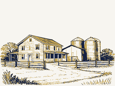
Submit the following items with the completed form: Estimated Burden Statement: Public reporting burden for this form is estimated to A USGS map (7.5 or 15 minute series) indicating the property's location. Services Division, National Park Service, P.0. Box 37127,Washington, DC street & number 2595 W. Lower Springboro Rd zip code 45006-9702 OMB No. 1024-0018 United States Department of the Interior National Park Service NATIONAL REGISTER OF HISTORIC PLACES CONTINUATION SHEET name of property Exterior Physical Description The Henry Decker Farmstead (Photo #1 & 2) is located one mile west of the city of Springboro, at the intersection of West Lower Springboro (formerly Springboro-Franklin Road) and Weidner Roads, in Clearcreek Township, northwestern Warren County, The property includes(approximately) ten acres of the original forty acre farmstead.
out-buildings primarily located at the northern edge of the property, on high ground facing Lower Springboro Road.The agricultural fields stretch south and southwest along a flood plain to a narrow woodland bordering the creek (Photo #3). have been constructed from ca. 1850 through the early 1900s. These include the workshop/poultry house, poultry house, two circular stone-lined wells and a cistern. The concrete foundation of a metal corn crib, destroyed in a wind storm and two main barn was recently demolished. However, the concrete walls of the stripping shed The two story, T-shaped, Stick and Eastlake Style house (Photo #4 & 5) was constructed ca. 1878. It sits on a locally quarried, limestone foundation. A basement runs the full length of the house and a crawl space is located under the living room.
The framing of the house is a combination of braced and balloon framing consisting of hewn beams and full dimensional studs which extend from the sills to the roof plate. (8-86) Ohio. House remain. The walls consist of wide, flat boards or sheathing nailed to the studs and clapboards include the original log house, what may have been a wash house with small bell tower, NPS Form 10-900-a takes its name. The property consists of both rolling and flat terrain, with the house and a hog house, an elevated water tank and the.corn crib.A tobacco shed attached to the concrete watering troughs also remain. Buildings and structures no longer extant house, summer kitchen, barn and attached wagon shed and corn crib, combination The farmstead retains eight of the original twelve buildings and structures known to NPS Form 10-900-a OMB No.
1024-0018 United States Department of the Interior National Park Service NATIONAL REGISTER OF HISTORIC PLACES CONTINUATION SHEET name of property Warren County, OH county and State which are nailed to the sheathing. The base of the house is finished off with a beveled water table. All windows are 1/1 double hung sash, many with original panes. There are three porches or verandasand six exterior doors, five with single glass panes and Eastlake style trim and a solid four-panel door which leads from the rear of the house to the summer kitchen. The steeply pitched roof is clad with wood shingles, replicating the original roofing material. Box gutters supported with small brackets are lined with sheet metal and are set back approximately one foot from the edge of the roof. Three corbeled chimneys penetrate the roof.
Characteristics typical of the Stick and Eastlake styles can be found on all elevations of wainscot above the water table and half way up the walls, delineating the first and second floors (Photo #6). The east elevation has a rectangular double bay window with narrow side windows (Photo #7). Wood-shingled awnings with braces shield first floor windows on the north, east and west elevations.All gable roof-ends are supported by scroll pendants which extend from the soffits to several feet below the roof line. are located on the second floor of the same elevations. Triangular panels beneath each hood contain sawn swan and sunburst relief designs. The verandas located on the north, west and east elevations have flat, mansard sheet metal and wood-shingle (incorporating part of the original mansard roof) and converted to a room ca. 1960s and (8-86) railings.
Lattice vents enclose the space below the tongue-and-groove floors. Porch roofs with bracketed box gutters. Heavy Eastlake style turned posts with fan-like veranda and square baluster railings support a smaller spindled frieze and beveled match their original appearance. elevations (Photo #8).Hooded gable dormers with smaller applied projecting trusses the house. Flat horizontal boards or banding frame vertical tongue and groove brackets support the porch roofs. A spindled frieze runs below the roof-line of each the west veranda had been removed. Both were reconstructed in the early 1990s, to NPS Form 10-900-a OMB No.
1024-0018 United States Department of the Interior National Park Service NATIONAL REGISTER OF HISTORIC PLACES CONTINUATION SHEET name of property Warren County, OH county and State Orientation and Plan Today, the main entrance of the house is from the west veranda, through the kitchen. However, the house was originally oriented to the north, with the main elevation facing Lower Springboro Road. Here, the north veranda leads to separate doors which open Springboro Road to the north side of the house (Photo #9). The driveway continued providing access to the property from either direction. A sidewalk which leads from the north veranda and ends in the yard provides additional evidence of this earlier orientation. In the 1970s the road grade was raised and banked on the south and a guard rail was installed eliminating the driveway and the historic access to the property.
In addition to the two north doors, a separate, seldom used door also leads from the west veranda to the parlor (dining room). The kitchen can also be entered from the east veranda and from the south side of the house, from a breezeway leading to the summer kitchen (Photo #4 & 5) (See house floor plan). Interior Description the living room and dining room (Photo #11). Both rooms feature cast-iron fireplaces with tiled-hearths, slate mantels, decorative fire-back and wooden over mantles with boy and girl on either side of the firebox. The interior walls retain much of the original when wall-paper was removed by a previous owner) is inscribed with the name: Farquar and dated April 5, 1905. The Farquar's were wall-paper hangers from Franklin, Ohio (8-86) closet.
Doors and windows are framed with symmetrically molded trim with corner The first floor of the house consists of a living-room, dining room, kitchen and walk-in plaster and wooden lath.A small area of the north wall of the living room (exposed kitchen features matching symmetrically molded window and door trim with corner blocks and a series of pointed arches (Photo # 10). A heavy, four-panel door separates blocks, a decorative pressed metal ceiling and a plate rail. ca. 1940's aerial photograph which shows a lane or driveway leading from Lower past the house to the agricultural buildings and then back to Lower Springboro Road, to the parlor (dining room) and the living room. This earlier orientation is verified from a mirrors (Photo #12). The dining room mantel features small framed relief tile busts of a NPS Form 10-900-a OMB No.
1024-0018 United States Department of the Interior National Park Service NATIONAL REGISTER OF HISTORIC PLACES CONTINUATION SHEET name of property Warren County, OH county and State which extends to the landing. There are simple brackets at the ends of the second floor stair risers. A substantial newel at the stair landing supports turned balusters and an oval handrail which extends to the upstairs hallway, forming an ell to enclose the stairway. The upper set of stairs have a simple molding below the nosing and simple brackets at the ends of the risers. The second floor contains three bedrooms and a bathroom. Before the house was plumbed the bathroom was part of the south There is access to a small attic through a shallow south bedroom closet.In contrast to the more formal rooms of the first floor the wood work and doors of the second floor are of simple design.
All woodwork and floors are painted. The four-panel doors retain the original Eastlake style hardware and original door handles. In 1994, the bathroom was remodeled in a design reminiscent of the early 1900s. The original wood floor was exposed and painted and wainscoating was installed. A marble sink and claw-foot cast iron tub were installed and a narrow one-over-one window matching the hall window, which had been covered, was reopened. The summer kitchen is a 14'x 10', timber-frame building, which appears to have been limestone piers and has a steep gable roof and vertical tongue-and-groove siding. The summer kitchen is connected to the house by a shared shed roof which covers a this space enclosed and it later contained a small bathroom.
The previous owner The two bay north elevation includes the entrance from the breezeway, through a four- panel door and a single 9 over 6 double hung window to the right of the door. The (8-86) Outbuildings contains an interior chimney which protrudes through the east end of the wood-shingled south and west elevations also have single six over six windows. The east elevation Summer Kitchen rebuilt the shed roof and recreated the breezeway as it might have originally appeared. The second floor is approached by a dog-leg, open string stair with an oak handrail, bedroom. The ceilings of the upstairs rooms generally conform to the gable roof form. concrete floored breezeway (Photo #3). A ca. 1890s photograph (Photo # 13) shows NPS Form 10-900-a OMB No.
1024-0018 United States Department of the Interior National Park Service NATIONAL REGISTER OF HISTORIC PLACES CONTINUATION SHEET name of property Warren County, OH county and State roof. The bricks at the top of the chimney are laid to form a triangular chimney cap. A box gutter which matches those on the house drains water from the shed roof and the north side of the summer kitchen roof. The interior walls and ceiling consist of vertical tongue-and-groove boards and the floor is comprised of random width boards. Evidence of a wood or coal-fired stove can be seen in a now-closed flu-pipe hole in the chimney.
Recent repairs (1996 and 1997) to the summer kitchen include the replacement of a badly deteriorated corner post and vertical siding at the northeast corner of the building, the addition of a matching beveled water table, dry-laid rubble stone enclosure of the spaces between corner piers and repairs to the flooring. The original barn is a 32'X 42', two-level, three-bay, timber-frame, threshing barn, with a limestone foundation. The gable-end barn has several gable-end and shed-roof two levels with a drive providing access to the second floor at ground level. The threshing barn consists of a central drive or threshing bay with wide random-width 21' extends along the right side of the threshing floor. Numerous trap doors open to the Opposite the stairway on the upper level are three granaries.
A haytrack is mounted in tobacco shed was badly deteriorated and was recently demolished and a new wall with 15). The concrete walls of the stripping shed remain. the loft. Barn barn door was constructed to enclose the exposed west elevation of the shed (Photo # (8-86) this order) include a wagon shed and corn-crib (possibly original); a rear gable-end peak; a rear shed-roof addition and a tobacco shed with adjacent stripping shed.The 10".The posts extend 14.5 feet from sill to plate.A massive swing beam, 15"X 10"X additions (Photo #14,14a & 15). The barn is constructed into the side of a hill, creating lower stabling area. A stairway leads to the stable and seven milking stanchions. The barn was added to on at least three or four occasions. The additions (probably in addition which formed a T-shaped barn; a small, gable-end wagon barn with a Gothic flooring and flanking bays and mows.
The main supporting posts and beams are 8" X NPS Form 10-900-a OMB No. 1024-0018 United States Department of the Interior National Park Service NATIONAL REGISTER OF HISTORIC PLACES CONTINUATION SHEET name of property Warren County, OH county and State this time a concrete floor was laid throughout the lower portion of the barn, with the exception of the tobacco shed. The milking stanchions appear to have been installed at this time. The concrete floor was designed to drain animal waste into the barn yard. A concrete pad, retaining wall, two concrete watering troughs and the concrete base for the corn crib were probably also constructed at this time. Like the tobacco shed itself, the rear shed roof addition appears to have been used for curing tobacco. Elongated doors remain on all elevations and long poles used for hanging the tobacco still lay on the rafters.
A circa 1940s aerial photo also shows what appear to be tobacco seedlings The barn retains a considerable amount of original hand-forged wrought-iron hardware, including strap hinges, latches and locking mechanisms. Perhaps the most unusual referred to as a windlass, which is located in the wagon shed. This early example of hand made farm machinery was probably used to lift wagons or other pieces of equipment for repair purposes. With the exception of the worn out ropes the winch is Workshop/Poultry House/Garage concrete foundation and beveled siding, is built into the bank just south and west of the structure contains a workshop on the ground level and a small poultry house or chicken A second 12'by 12'shed-roof poultry house is located on flat ground southwest of the windows on the south and west elevations (Photo #18). Both poultry houses contain (8-86) their original roosts. intact.
(Photo # 16 &17). house.The south-facing house or coop is entered from the east elevation and includes house. A small brick chimney protrudes from a standing seam metal roof. The Poultry House The basement of the barn appears to have been remodeled in the 1920s-1940s.At shaded with white cloth (Photo # 9). feature of the barn is a devise known as an "overhead beam winch", sometimes A two level 18' by 20', timber and balloon frame, gable-end building with poured OMB No. 1024-0018 United States Department of the Interior National Park Service NATIONAL REGISTER OF HISTORIC PLACES CONTINUATION SHEET name of property Warren County, OH county and State Stone-lined Wells and Cistern The property retains two circular limestone-lined wells. One is located next to the house and continued to provide water for domestic purposes until the 1980's, when county water was installed.
The other well is located near the corn crib and at one time powered pumping system. A cistern is located behind the house next to the summer (8-86) kitchen. NPS Form 10-900-a Section NPS Form 10-900-a OMB No. 1024-0018 United States Department of the Interior National Park Service NATIONAL REGISTER OF HISTORIC PLACES CONTINUATION SHEET name of property 3. Kitchen 5. Summer Kitchen (8-86) 2. Dining Room 1. Living Room Warren County, OH 4. Hallway county and State Page _8 Decker, Henry Farmstead Section 7 NPS Form 10-900-a OMB No.
1024-0018 United States Department of the Interior National Park Service NATIONAL REGISTER OF HISTORIC PLACES CONTINUATION SHEET name of property Warren County, OH county and State The Henry Decker Farmstead is eligible for the National Register under Criterion C, as an example of a small 19th and early 20th century farmstead, consisting of both pattern buildings are significant because the complex is relatively in tact and because it The Land and the Landscape The Henry Decker Farmstead is located on an Ohio Land Grant known as The Land Between the Miamis, because it bordered the "Virginia Reservations" or Virginia Military Lands, separated by the Little Miami River on the east and the Great Miami River on the west. Miamis and north of the Symmes Purchase, including all but a fraction of central and system, previously adopted by Judge Symmes.
However, some of "Symmes Settlers" had already located on the land in advance of the surveyors, thinking they were within lines to fit their improvements. This accounts for many of the crooked section lines north of the Symmes Purchase. Thomas Jefferson for Section 18, Township 3, Range 4, dated 1807, grants him such a and the original gable-end barn. An 1867 Atlas Map of Warren County shows a house It was Decker who built the new farmhouse, summer kitchen and other out-buildings. (8-86) located near the creek. Antrim farmed the land until selling it to Henry Decker in 1877. preemption. The 40 acre farm that was to become the Henry Decker Farmstead was right of preemption to their location and directed the surveyor general to run the section the Symmes Purchase.
In 1799 and again in 1801, Congress gave these settlers the represents nearly 150 years of farming practices and changing architectural needs. On March 3,1801, Congress passed a law for the subdivision of the land between the western Warren County. The region was to be subdivided in the township and range book, high style domestic architecture and vernacular agricultural buildings. The farm Daniel Richardson was apparently one of "Symmes Settlers" for the original deed from part of this section. The farm began to take shape in 1833, when Abel Janney deeded approximately 39 acres and a mill dam to Griffith Hinchman. Daniel Antrim acquired NPS Form 10-900-a OMB No. 1024-0018 United States Department of the Interior National Park Service NATIONAL REGISTER OF HISTORIC PLACES CONTINUATION SHEET name of property county and State tobacco, it is not know what was historically grown on the farm.
One can assume, however, that small fields of hay and corn were grown for the dairy cattle. The farm also likely included a large kitchen garden. The property remained a 40-acre farm until farming was discontinued ca. 1961. Though it was the smallest farm in the township in 1858, it was located in an area where farm size seldom exceeded 100 acres and where farms of considerably less than the Symmes Purchase, discussed earlier. As the century progressed, many larger Springboro. Today, because of urban sprawl, there is little resemblance to the historic landscape, particularly in eastern Clearcreak Township. Though only ten acres of the original 40 acre farmstead remain, the configuration of the acre) bottomland fields spread out along Clearcreek.
In addition, six acres of the Property included in this nomination remain in agriculture, with another acre in grass, Henry Decker House and Summer Kitchen architectural curiosities in northern Warren County, an area still dominated by the sturdy, unadorned, box-like, 1 and double pile, masonry houses of its early Quaker The Henry Decker house is a good example of high-style Stick and Eastlake style (8-86) buildings. settlers. thus maintaining the historic appearance of the area surrounding the farmstead common. This may have been due to the growing population in and around 100 acres were common. This may have been due to the history of the land north of architecture, particularly in its rural setting. In fact, the house retains most of the The Stick and Eastlake Style house and complementary summer kitchen remain Warren County.
OH original farmstead is basically the same, with fence rows separating small (six-eight farms began to be broken up and sold off. By 1903, farms of 20-30 acres were The Decker family owned the property until selling to Isaac Treon in 1917. Other than NPS Form 10-900-a OMB No. 1024-0018 United States Department of the Interior National Park Service NATIONAL REGISTER OF HISTORIC PLACES CONTINUATION SHEET architectural features characteristic of these styles. These include an overall vertical orientation, patterned wall surfaces (clapboards and imbricated shingles) horizontal and ornamental Eastlake-influenced verandas with heavy turned posts, balustered porch cresting on all three veranda roofs and forked finials at each of the house's gabled house. Characteristics which contribute to this vertical orientation include vertical siding and the steeply pitched roof.
A Pattern Book House The Henry Decker House may have been built from published architectural plans, a late publications such as A.J. Bicknell & Co., Bicknell's Victorian Buildings, American house descriptions, a customer could then hire a local contractor or builder to construct the house or build it himself. (8-86) peaks. Guide, by George E. Woodward & Edward G. Thompson, included elevations, Scores of books and periodicals were published by enterprising architects attempting to Ladies' Home Journal. Armed with professionally drawn working drawings and detailed name of property Architects also advertised their plans in the major periodicals of the day, such as county and State drawings, floor plans, cost estimates, specifications and a sample contract form. Victorian Cottage Homes, by Palliser, Palliser & Co.
and A Victorian Housebuilder's characteristics of the style original to the house but no longer present, include metal Warren County, OH Section Page _3 Decker, Henry Farmstead The summer kitchen, though much simpler in design, mimics the verticality of the business. Mail order architectural plans appeared in book and portfolio form decorative gable treatment. These features are further enhanced by three highly (generally referred to as plan or pattern books) or in periodicals. Many of these expose themselves to the largest possible audience. Books were often arranged NPS Form 10-900-a OMB No.
1024-0018 United States Department of the Interior National Park Service NATIONAL REGISTER OF HISTORIC PLACES CONTINUATION SHEET name of property Warren County, OH county and State Though a survey of the above publications and others has not turned up a published plan matching the design of the Henry Decker House, there are many similarities to those of similar size and scale. The failure to locate a matching plan is not surprising Decker House, the builder also used a more conservative braced framing technique, mentioned in the table of contents of R.W. Shopnell's, How to Build, Furnish and Decorate, including "Gothic, Queen Anne, Mansard, Shingle, Italianate and Swiss houses in Clearcreek Township revealed a small number of late Victorian houses but none with the elaborate detail and strong influence of the Stick and Eastlake styles found on the Henry Decker farmhouse.
and crop operation. Though several of the buildings and structures, including the water tower, hog house, and metal corn crib, are no longer extant, those that remain The barn provides the clearest evidence of changes, having undergone numerous (8-86) styles." additions and alterations. The original three-bay barn, hand-hewn and sawn timber- According to a ca. 1940 photograph, the Henry Decker farm building complex was a frame structure ca.
1860, probably functioned as a threshing barn, with hay or straw stored in mows on either side of the threshing floor and grain stored in granaries Agricultural Buildings opposite the stairway to the stable below.A massive swing beam typical of threshing since plans were often altered during the building phase.In the case of the Henry house is typical of the variety of choices illustrated in the above publications and represent nearly 150 years of farming practices and changing agricultural needs. somewhat densely concentrated, self contained area consisting of the barn and numerous out-buildings and structures designed to accommodate a small-scale animal NPS Form 10-900-a OMB No.
1024-0018 United States Department of the Interior National Park Service NATIONAL REGISTER OF HISTORIC PLACES CONTINUATION SHEET name of property county and State and turning of the horse teams unhindered by a post. Large threshing doors through which straw could be thrown or blown to form straw stacks, were located on the down- slope side of the barn. The doors were eliminated with the construction of a rear gabled-end addition. Cuts in the posts on either side of the opening, to accommodate verifies this function. such as wagons or other farm equipment for repair purposes or possibly animals for By the last quarter of the nineteenth century, southwest Ohio had become an important It was during the late nineteenth or early twentieth century that the Deckers, like many probably provided a much needed cash infusion for the small farming operation. The Treons continued this tradition.
(8-86) A small, gable-end wagon or carriage barn, ca. 1870s was constructed next to the central bay or drive, forming an ell. The wagqn barn contains a small loft. also sometimes referred to as a windlass. The winch was used to hoist heavy items, of their neighbors, began growing cigar tobacco. This labor-intensive but profitable crop barns extends along the right side of the threshing floor, permitting threshing of grain Warren County. OH Possibly contemporary with the threshing barn or added soon after is the timber-frame butchering. Machines of this type may have been common in nineteenth century barns timber-frame corn crib. The slant-sided corn crib is said to be constructed in this fashion to shelter the corn from the weather and because it was easier to unload.
was centered in Montgomery and Darke counties, the presence of tobacco barns across much of southwest Ohio indicate a much larger growing area. hinges verify this former barn feature. The addition created additional second floor grain storage capacity and sheltered space for farm animals below. A large trap door NPS Form 10-900-a OMB No. 1024-0018 United States Department of the Interior National Park Service NATIONAL REGISTER OF HISTORIC PLACES CONTINUATION SHEET name of property county and State shed roof addition was added to the south elevation. A long, 100' X 40' low, gabled-end air-cured cigar tobacco barns, was constructed next to the west elevation and joined to the rear shed (Photo # 9). the rear shed and larger tobacco barn were sited in this manner.
Characteristics typical of Ohio air-cured tobacco barns present on the shed and recently demolished tobacco barn include outside-mounted sliding doors which provided access doors which could be opened on warm, bright days with low humidity and closed in the also remain in the tobacco shed. The stripping shed contained a small stove which kept the building warm during late-fall enough to keep the tobacco pliable in order to avoid shredding. The walls of the location of the stove. and waste disposal for the small dairy operation. The metal stanchions also may have (8-86) nineteenth century. been added at this time. Finally, though the original threshing barn form remained the turn of the twentieth century. Probably as a response to more stringent agricultural According to geographer Karl Raitz, air-cured tobacco barns were constructed with Warren County.
OH The barn was enlarged, doubling its size, to accommodate the air-curing of tobacco. A south and west facing exposures to take advantage of prevailing wind direction. Both tobacco barn, sometimes called a shed, with attached stripping shed, typical of Ohio NPS Form 10-900-a OMB No. 1024-0018 United States Department of the Interior National Park Service NATIONAL REGISTER OF HISTORIC PLACES CONTINUATION SHEET Warren County, OH Refer to the barn plan for the location and estimated construction dates of the additions and alterations. small and could accommodate only a few dozen chickens. One of the poultry houses is located in the lower level of a multi-use structure. Probably typical of small farming operations, this structure also housed a workshop and small garage. The workshop area was heated by a small wood stove connected to a brick chimney.
The second poultry house is a shed roof structure typical of early twentieth century poultry houses, includes windows and a louvered ventilator on the south-facing exposure. Stoned-lined Well One of the two circular stone-lined wells is located next to the corn crib. Concrete is no longer extant. Later an electric pumping system was used to fill the troughs. Despite the previously discussed changes to, the barn, the small size of the Henry marginally in the new construction technologies and scientific farming practices which primarily alterations and additions to the barn to accommodate the growing of tobacco. economically feasible. (8-86) name of property building practices, economics may have also played a part in the Decker's and Treon's decision.
Change occurred only when it could significantly increase farm income, Poultry Houses county and State watering troughs were constructed next to the well and at the rear of the wagon shed. Section Page 7 Decker, Henry Farmstead Like most of the other out-buildings on the Henry Decker farm, the poultry houses are similar to that illustrated in Farm Buildings, Sanders Publishing Company, 1907. It Iron pipes carried water to the two troughs and probably to a gravity water tower which brought dramatic changes in American agriculture after the turn of the century. Decker farmstead probably allowed the Deckers and later the Treons to participate only Though many farmers did not feel compelled to abandon or alter traditional farming and OMB No.
1024-0018 United States Department of the Interior National Park Service NATIONAL REGISTER OF HISTORIC PLACES CONTINUATION SHEET Page _8_ Decker, Henry Farmstead name of property Warren County, OH county and State Today the Henry Decker farmstead provides us with an increasingly rare example of nineteenth and early twentieth century subsistence or small cash-crop farming practices in southwest Ohio. (8-86) Section NPS Form 10-900-a NPS Form 10-900-a OMB No. 1024-0018 United States Department of the Interior National Park Service NATIONAL REGISTER OF HISTORIC PLACES CONTINUATION SHEET Warren County, OH 4. Tobacco Shed, ca. 1900 2. Gable End Wagon Barn, ca. 1870s 5. Tobacco Barn, ca. 1900 3. Wagon Barn/Corn Crib, ca. 1860 6. Rear gable-end addition, ca. 1870s (8-86) name of property 1. Threshing Barn, ca. 1860 county and State Section OMB No.
1024-0018 United States Department of the Interior National Park Service NATIONAL REGISTER OF HISTORIC PLACES CONTINUATION SHEET name of property Warren County, OH county and State Major Bibliographical References Bock, Gordon. "Mail-Order Interiors". Old-House Journal, November/December, 1989. Chain of deed/title (7-1-1807/12-20-79), records office Warren County, Ohio. Complete Atlas of Warren County, Ohio Lebanon: Frank A. Bone, 1891. Copy of original deed from Daniel and Nancy Richardson to Samuel Caldwell, 1813. Identifying Mail Order Houses. Old-House Journal, September/October, 1995. Interview with Issac Treon, Jr. by Susan Swan (previous owner) 1992. McAllister, Virginia and Lee. A Field Guide to American Houses. New York: Alfred A. Anthony D. Byles, 1856. Map of Warren County, Ohio from actual surveys by G. P. Sanford, J. Sillman Higgins and R. H. Harrison (C.E.) Philadelphia: A.
Warner, 1867. (8-86) Map of Warren County, Ohio from actual surveys by P. O'Beirne (C.E.) Philadelphia: Combination Atlas Map of Warren County, Ohio by L.H. Evers, 1875. Knopf, 1984. NPS Form 10-900-a Richardson, 1807. Copy of Original deed signed by Thomas Jefferson, President of US to Daniel Interview with Paul Kennedy by Susan Swan, (previous owner) 1992. OMB No. 1024-0018 United States Department of the Interior National Park Service NATIONAL REGISTER OF HISTORIC PLACES CONTINUATION SHEET Warren County, OH Old-House Journal, November/December, 1989. Noble, Allen G. and Richard K. Cleek. The Old Barn Book: A field Guide to North American Barns and Other Farm Structures. New Jersey: Rutgers University University Press, 1995. Sherman, C. E. Ohio: The Ohio State Reformatory, 1925. Centennial Atlas Association, 1903. (8-86) Press, 1996.
The Centennial Atlas of Warren County, Ohio by Will S. McKay.Lebanon: The Noble Allen G.and Hubert G. H.Wilhelm(eds).Barns of the Midwest.Athens:Ohio county and State NPS Form 10-900-a name of property Section Page 2 Decker, Henry Farmstead Massey, James C. and Shirley Maxwell."Planbook Houses: Architecture By Mail". OMB No.
1024-0018 United States Department of the Interior National Park Service NATIONAL REGISTER OF HISTORIC PLACES CONTINUATION SHEET county and State Verbal Boundary Description Situated in the township of Clearcreek, County of Warren and State of Ohio in Section 13, Town 2 East, Range 5 North, and being Tract #1-B, 3.816 acres in the County deed records; said 3.816 acre tract being bounded and described as follows: Beginning at a point on the centerline of Lower Springboro Road, said point being found by measuring from the point of intersection of the centerline of Factory Road with the easterly line of said original 6.679 acre tract the following courses: (1) south 14 deg. 40' of said tract south 86 deg.
58'18"west 254.90 feet to the southwesterly corner of said the point of beginning containing 3.816 acres according to a plat (drawing c-7712) by Situated in Section 13, Town 2 East, range 5 North, Clearcreek Township, Warren more particularly described as follows: Beginning at a stake found on the northeasterly corner of'a 8.401 acre tract (O.R. 655, (8-86) Pg 804, S.R. 80, Pg.79) on the centerline of Lower Springboro Road; said point of NPS Form 10-900-a following courses: (1) north 83 deg. 02' 22' east 1974.81 feet (2) and thence north 86 Duane, Hasselbring, Kuhlman & Associates, Registered surveyors, Middletown, Ohio, 30' 20" east 428.88 feet to a point in Weidner Road, thence in said road and along April, 1981 beginning and continuing along the centerline of Lower Springboro Road south 68 deg.
deg.58' 18" east 483.24 feet to the point of beginning: Thence from said point of 00"west370.67feet(2) south20 deg.53"40"west55.80 feetto the most Warren County. OH name of property Record 141,page 442 and Survey Record 46, Page 11; said 5.9440 acre tract being southwesterly part of an original 6.670 acre tract, deed book 46, page 835, Warren southeasterly corner of said original 6.679 acre tract, the same being the southerly line tract; and thence along the westerly line of said tract 3 deg. 01' 42" west 582.14 feet to County, Ohio and being part of an original 40.004 acre tract as recorded in Official beginning being found by measuring from a spike found on the northeasterly corner of OMB No.
1024-0018 United States Department of the Interior National Park Service NATIONAL REGISTER OF HISTORIC PLACES CONTINUATION SHEET name of property county and State pin found; (2) and thence North 87 deg. 02' 40" east 159.00 feet to the point of beginning; Thence from said point of beginning and continuing along said centerline North 87 deg. 02' 56" east 324.09 feet to an iron pin found on the northeasterly corner of a 3.816 acre tract (O.R. 521, Pg. 511, S.R. 46, Pg.21); Thence along westerly and feet to the southwesterly corner of said tract; (2) North 86 deg. 58'18" East 254.90 feet, 3.816 acre tract on the centerline of Weidner Road; Thence along said centerline South 20 deg.
53' 40" West 230.14 feet to the southeasterly corner of the aforesaid original 472.88 feet, passing an iron pin found at 26.51 feet, to an iron pin found on the southeasterly corner of the aforesaid 8.401 acre tract; and thence along the easterly line of said tract North 5 deg. 32' 40" West 669.42 feet to the point of beginning containing 5.9940 acres more or less of which 0.2230 acres are in Lower Springboro Middletown, Ohio, September, 1992. Boundary Justification: (8-86) maintain historic integrity. (8/86) Survey (Drawing C-9997) by Duane & Assoc., Inc., Ohio Professional Surveyors, The boundary includes the farmhouse, outbuildings and approximately 1/4 of the fields Warren County.
OH southerly linesof said tract the followingcourses;(1) south3 deg.01'42"east582.14 and forest that have historically been part of the Henry Decker Farmstead and that K.E.G.G.Subdivision (P.B.17, Pg.66) on the aforesaid centerline and along said NPS Form 10-900-a 40.004 acre tract; Thence along a southerly line of said tract North 77 deg.48' 17"west centerline the following courses: (1) North 83 deg. 02' 22" east 345.64 feet to an iron Road right-of-way and 0.2835 acres are in Weidner Road right-of-way, according to a OMB No. 1024-0018 United States Department of the Interior National Park Service NATIONAL REGISTER OF HISTORIC PLACES CONTINUATION SHEET _Page 1 Decker, Henry Farmstead name of property Warren County, OH county and State All photographs taken between March and November, 1999 by Glenn A. Harper. except for two historic photographs 9 and 13. 1.
View of the farmstead, camera facing northeast 3. Farm field, camera facing southwest 4. House and summer kitchen west elevation, camera facing east 6. House east elevation, camera facing west 7. Bay window east elevation, camera facing southwest 8. Gable detail west elevation, camera east 9. Aerial historic photograph of farmstead, circa 1940s 10 Window trim, camera facing east 11. Door and trim camera facing east 12. Mantel, camera facing east east, ca. 1890s 14a. Interior, timber-frame barn 14. Barn, north and east elevation, camera facing southwest 15. Barn, south and west elevation, camera facing northeast 16. Barn, overhead beam wench, camera facing south camera facing northeast (8-86) 13. Historic photograph of house and summer kitchen west elevation, camera facing 18.
Workshop/Poultry House and Garage/Poultry House, south and west elevation, NPS Form 10-900-a Section Photographs Originals and negatives in possession of the owners, Glenn Harper and Carole Endres Decker, Henry Farmstead -233 AC A. Barn B. Well C. Poultry House/Workshop D. Poultry House E. House/Summer Kitchen F. Well G. Cistern Sketch Map Warren County, Ohio 5. 9940 Clearcreek 321'.09' N 87º 62'56"º E 699. 3.816 Lowew Springbovo Springbovo NATIONAL PARK SERVICE EVALUATION/RETURN SHEET NAME : DATE RECEIVED: DATE OF 16TH DAY: DATE OF 45TH DAY: APPEAL: N OTHER : PERIOD : PROGRAM UNAPPROVED: REQUEST: N COMMENT WAIVER: N ABSTRACT/ SUMMARY COMMENTS: RECOM.
/CRITERIA RETURN TELEPHONE DATE MULTIPLE DISCIPLINE 8/08/00 REVIEWER REJECT 9/22/00 SAMPLE: PDIL: REASONS FOR REVIEW: NATIONAL REGISTER OF HISTORIC PLACES LESS THAN 50 YEARS: DOCUMENTATION see attached comments Y/N see attached SLR Y/N DATE OF WEEKLY LIST: UNITED STATES DEPARTMENT OF THE INTERIOR DATA PROBLEM: N LANDSCAPE: N N SLR DRAFT: N 9/06/00 PROPERTY ACCEPT Decker, Henry, Farmstead NATIONAL: warren Co, OHio warren Co., ohio DEcker-Tkeon Faronstend Decker-Fltou Falmstead Decker -TReou Farmskead Warren co, oltio warren co, ortio Warren Co., otro Decker-froon Farmstead SPRINGBORO.
OHIO GEOLOGICAL SURVEY OHIO 7.5 MINUTE SERIES (TOPOGRAPHIC) SPRINGBORO QUADRANGLE UNITED STATES DEPARTMENT OF THE INTERIOR BOARD OF TRUSTEES Ed Wade Ohio Historic Preservation Office AUG 8 <UU 567 East Hudson Street Columbus, Ohio 43211-1030 RE: Decker-Treon Farmstead the Decker-Treon Farmstead to the National Register of Historic Places. We have also discussed the nomination with local historian Don Ross of Springboro. This Board is proud to endorse the nomination of the Decker-Treon Farmstead to THE BOARD OF CLEARCREEK TOWNSHIP TRUSTEES 748 - 1267 Fax: 748-3252 Respectfully, 1-800-824-5124 www.clearcreektownship.com ERVICE Dear Dr. Loveday, CLERK TOWNSHIP HISTORY Clearcreek ATTN: Dr. Amos J. Loveday, Jr. the National Register. The Board of Clearcreek Township Trustees has reviewed the forms nominating NATIONAL RECEIVED James A. Dalton MAT 2 6 2000 Gregory A. McDonald. D.D.S. R.
Dale Lamb Ohio 45066 REC'D BY OHPO
 Block
Block