MAJOR BIBLIOGRAPHICAL REFERENCES Historical Society, 1972. Columbus, Ohio. Printing Company, 1969, page 93- Volume 4, Lawrence County.
LO GEOGRAPHICAL DATA ACREAGE OF NOMINATED PROPERTY less than one VERBAL BOUNDARY DESCRIPTION - COUNTY FORM PREPARED BY April 18, 1975 Whitehead Road Col umbus 12 STATE HISTORIC PRESERVATION OFFICER CERTIFICATION THE EVALUATED SIGNIFICANCE OF THIS PROPERTY WITHIN THE STATE IS: NATIONAL - LOCAL _ As the designated State Historic Preservation Officer for the National Historic Preservation Act of 1966 (Public Law 89-665).F hereby nominate this property for inclusion in the National Register and certify that it has been evaluated according to the August 15, 1975 FOR NPS USE ONLY DATE NOV 1 11975 KEEPER OF THE NATIONAL REGISTER 614-279-9576 DATE NORTHING ORGANIZATION SIGNATURE STATE TELEPHONE ZONE NAME/TITLE CODE UTM REFERENCES ZONE EASTING Record Books of the Southern Ohio Covered Bridge Association, Ohio Covered Bridges of Ohio.
Ohio Covered Bridge Committee and the Ohio Ketcham, Bryan E., Covered Bridgeson the Byways of Ohio, Oxford Miriam F. Wood STREET & NUMBER criteria and procedures set forth by the National Park Ser ATTEST: State Historic Preservation Officer Acting Director. Photos _ To HAER NOV 8 1 1975 Entered OTHER KEEPER ARCHEOLOGIST Send-back CONTROL Maps TECHNICAL Re-submit Inventory Review Federal Register Entry National Register Write-up HISTORIAN REVIEW UNIT CHIEF State Lawrence BRANCH CHIEF Working Numberg. 1 9. 75. 15 9/ 750014560 8.21.75 ARCHITECTURAL HISTORIAN IN T:2106-74 Property United States Department of the Interior National Park Service WAso No.7 2-3-76 11.1025 NPS Number PROPERTY OF THE NATIONAL REGISTER Scottown Covered Bridge South Portal, east side, Looking northwest3/5 Loc ½ mile oastof Scottoun Lawrence County, Ohio Form No. 10-301a (Rev.
10-74) UNITED STATES DEPARTMENT OF THE INTERIOR FOR NPS USE ONLY NATIONAL PARK SERVICE NATIONAL REGISTER OF HISTORIC PLACES PROPERTY PHOTOGRAPH FORM TYPE ALL ENTRIES --IENCLOSE WITH PHOTOGRAPH AND/OR COMMON CITY, TOWN -VICINITY OF PHOTO REFERENCE DATE OF PHOTOMarch 26, 1975 DESCRIBE VIEW. DIRECTION, ETC. IF DISTRICT. GIVE BUILDING NAME & STREET INT: 2983-75 Lawrence IDENTIFICATION COUNTY HISTORIC STATE NAME one-half mile east of Ohio PHOTO NO. Scottowm Covered Bridge South portal, east side of bridge, looking northwest. SEE INSTRUCTIONS IN HOW TO COMPLETE NATIONAL REGISTER FORMS NEGATIVE FILEDAT3155 Whitehead Road,Columbus, Ohio 43204 PHOTO CREDIT Miriam F. Wood RECEIVED AUG 1 9 1975 Scottown South portal, Looking north Title: PROPERTY OF THE NATIONAL REGISTER Loc Clozx Scottocwn Covered Bridge Form No.
10-301 UNITED STATES DEPARTMENT OF THE INTERIOR NATIONAL PARK SERVICE NATIONAL REGISTER OF HISTORIC PLACES PROPERTY MAP FORM IDA TE ENTERED SEE INSTRUCTIONS IN HOW TO COMPLETE NATIONAL REGISTER FORMS TYPE ALL ENTRIES -- ENCLOSE WITH MAP AND/OR COMMON CITY, TOWN VICINITY OF SOURCE U.S.G.S. Aid, Ohio, Quadrangle TO BE INCLUDED ON ALL MAPS 1. PROPERTY BOUNDARIES 2. NORTH ARROW 3. UTM REFERENCES INT: 34 64- 75 Lawrence COUNTY DATE HISTORIC STATE REQUIREMENTS Ohio Scottowm Covered Bridge NAME one-half mile east of MAP REFERENCE FOR NPS USE ONLY RECEIVED AUG 1 9 1975 Scottown SCALE 1 :24000 AID QUADRANGLE UNITED STATES DEPARTMENT OF THE INTERIOR 7.5 MINUTE SERIES (TOPOGRAPHIC - UM 17 379720 426729 - 32'30 GEOLOGICAL SURVEY Erie County St. Martin's Catholic Church Hon. Charles N. Whalen, Jx. Hon. Charles A. Mosher Hon, Clarenca B.
Miller INT: 2950-75 11/14/75 Location Sandusky STATE Name Date Entered MMott/row Medina County Also Notified Scottom vicinity Dayton vicinity Bracevillevicinity ENTRIES IN THE NATIONAL REGISTER Regional Director, Midwest Region Montgonery County Lawrence County Gxeene County Director, The Ohio Historical Society Bellbrook vicinity Scottowm Covered Bridge Mason, John Wesley, Gothic Cottage Trumbull County Valley City vicinity. Llverpool State Ristorio Preservation Officer Dr.Tomas H.Smith Hon. Clarence J. Brow 43211 Berryhill-Morris House Deerwood Farm Carnegie Library Hon.J. william Stanton PH 02.80585 1. NAME OF STRUCTURE 3. NATURE OF STRUCTURE BT&A: TRUSS :COVRD 5. LOCATION: STREET & NUMBER CITY OR TOWN County road [ STATE S. USGS QUAD MAP & UTM GRID REF. ; OWNER OF PROPERTY AID, OHIO Ironton, OH X GOOD 8.
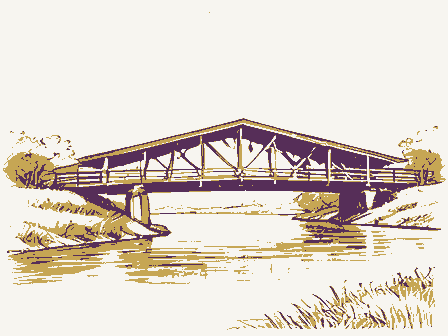
CONDITION: X ALTERED X ACCESSIBLE TO PUBLIC The truss type is called an adaptation of the basic multiple kingpost.Over the years, the bridge has was replaced in 1971, and the roofing company furnished signs for each portal which read "Scottown Bridge 10. PHOTOGRAPHS & SKETCH MAP ON REVERSE SIDE CONST C Covered Bridges of Ohio, Ohio Covered Bridge Committee and the Ohio Historical Society, 1972, Columbus, OH. Bryan E. Ketcham, Covered Bridges on the Byways of Ohio, Oxford Printing Co., 1969, p. 93 NATURE OF THREAT 14. EXISTING SURVEYS NHL J LOCAL 15.
INVENTORIED BY: YOUR NAME 1874 17.379720.4267290 10/27/75 AFFILIATION EXCELLENT DATE FRAME LAWRENCE FENES Lawrence County METAL UNEXPOSED COAL RUINS OTHER Beverly Baynes TUNLS HABS ANCIL DETERIORATED SURVEY CHEM FAIR MATH TEXT HEAT Record Books of the Southern Ohio Covered Bridge Association; Vol.4,Lawrence County MATS AND DATES: has been replaced by sheet metal siding and the stone abutments are reinforced with concrete. FOUND ROOF ADDRESS SCOTTOWN COVERED BRIDGE IRON AGRI of an old hand-adze can still be Seen on some of the timbers of this bridge,but the original sid&ing 13.PRIORITY 1/2 mile east of Scottown ADAPT is length:80').Width:17'4"(roadway width:13'3").Vertical clearance:11'.The roof HOUS P&ET DAM PRESENT WOOD «AER HAER INVENTORY 4. INDUSTRIAL CLASSIFICATION EQUIPMENT; APPROX.
AREA OF SITE: ALTERATIONS; PRESENT USE; ENGINEER/ ARCHITECT DESIGNER; IMPORTANT EVENTS & INDIVIDUALS been heavily reinforced with steel rods, gussets, channels and I-beams. The overall length of the bridge 11. RELATED SOURCES OF INFORMATION: HISTORICAL REFERENCES (PUBLISHED ARTICLES, MANUSCRIPTS, REPORTS, DRAWINGS, PHOTO GRAPHIC RECORDS) CONTACTS: (NAMES & ADDRESSES OF ANYONE WITH EYE-WITNESS ACCOUNTS OR RELEVANT INFORMATION); TAPE RECORDINGS. 12. DANGER OF DEMOLITION OR DAMAGE [] YES LJNO 1/12/75 (2) PLEASE RETURN TO THE HISTORIC AMERICAN ENGINEERING RECORD, NATIONAL PARK SERVICE, WASHINGTON, DC 20240 9.
DESCRIPTION & BACKGROUND HISTORY: NUMBER OF STRUCTURES; DIMENSIONS: FABRIC;STRUCTURE & FORM: SURVIVING MACHINERY, FITTINGS AND UTILITIES (UTID) FERROUS WATER MUSEUM COMM MECH HYDRA BPGC The Scottown Covered Bridge lies within the historic Hanging Rock Iron is the last covered 1923 MNRL H.FI XNR Sydate of entry: 4 county code: / town State GNPS REGION SOURCE of NOMINATION 1 CONDITION O deteriorated ) XXUBSTANT IALLY INTACT -3 Oruins Dunaltered Omoved O-NOT INTACT - O Qunexposed Oreconstructed EO UNKNOWN -4 -unexcavated 20 NOT APPLICABLE -7 XYES -Unrestricted - No Access AREAS OF SIGNIFICANCE : X ENGINEERING -11 - LANDSCAPE ARCH.- 15 - POLITICS / GOVT.
21 -RECREATION -28 OCLAIMS: explain CARCHEOLOGY- prehistoric-2 - COMMERCE-6 C ENTERTAINMENT-26 - LAW - 16 - RELIGION- 22 C SETTLEMENT-29 - ARCHEOLOGY-historic-1 - COMMUNICATIONS -7 -EXPLORATION - 12 - LITERATURE - 17 - SCIENCE- 23 - URBAN PLANNING-31 -AGRICULTURE -3 C CONSERVATION- 8 - HEALTH -27 C MILITARY- 18 - ARCHITECTURE-4 - ECONOMICS-9 C INDUSTRY-13 - MUSIC - 19 - SOCIAL / CULTURAL - 30 'only' IX county's only remaining - ART-5 - EDUCATION-10 - INVENTION - 14 - PHILOSOPHY -20 X TRANSPORTATION - 25 3) functions @architectural style(s): * landscape architoet/ garden designer: 3 interior decorator: @artisan: IF ADDITIONAL SPACE NEEDED, NUMBER& PUT ON REVERSE 1874 construction.
Bridge ASSOCIATION 4/12/78 FEDERAL INSTITUTIONAL: covered bridge PERSONAL: artist: EVENTS: historic events: builder/contractor: reviewers initials 11-12-75 PRIVATE ORGANIZATION Xoriginal site NATIONAL REGISTER WRITE-UP ADMINISTRATOR: Dexcellent LOCAL Wicinity of master builder: IS PROPERTY A HISTORIC DISTRICT?yesno SAVED?YES NAME as it appears on federal register: 2 OTHER NAMES: Xxl tered 17) features: 20th c.?, reinforced _date. Laurence @arohiteet: NATIONAL CURRENTLY: major alterations: WHEN HISTORICALLY SIGNIFICANT: REGISTER DATA SHEET dates of initial construction: during last century roof replaced,1971.County's only remaining covered bridge; incorporates unusual type of truss COUNTY MULTiPLE FEDERAL(agency name) Dfair Scottoun
 Block
Block