
BlockBefore
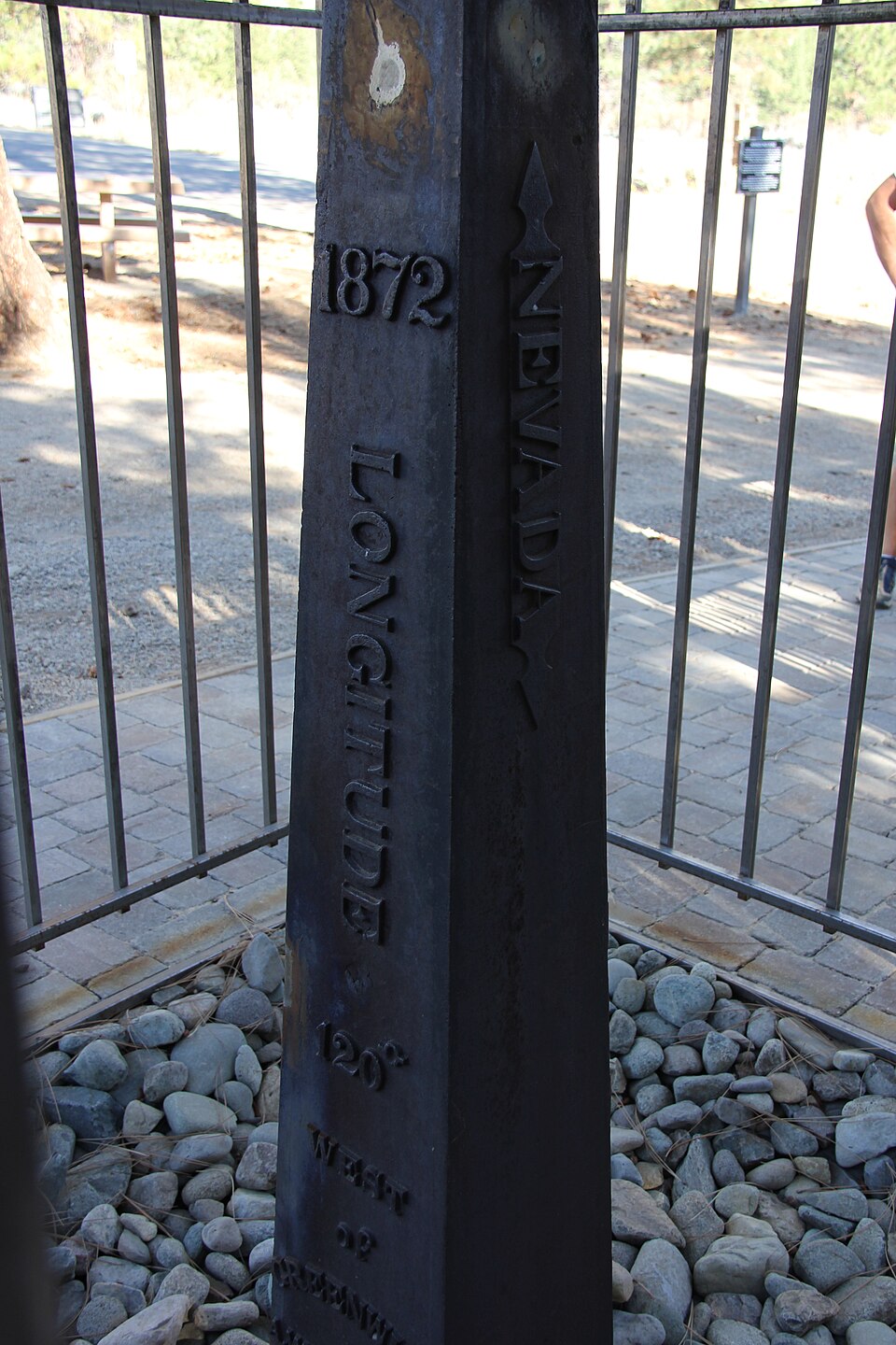
Photograph of 1872 California-Nevada State Boundary Marker
Photograph by ThirteenOaks, CC BY-SA 3.0. Via Wikimedia Commons.

1872 California-Nevada State Boundary Marker

Listed on the National Register of Historic Places in 1981.

From the record

“The 1872 California-Nevada State Boundary Marker marks the initial point for the 1872 survey delineation of the state line between California and Nevada. The boundary marker is a small cast iron obelisk near Verdi, Nevada.”

Wikipedia article 1872 California-Nevada State Boundary Marker, CC BY-SA 4.0.

One of 83 National Register listings published here for Washoe County · listed in 1981 · category: Object.

Sources: the Wikipedia article · the case file at the National Archives · the National Register database, National Park Service

The listing

  • What is counted as historic. The nomination lists 1 object as contributing to the listing.
  • Address. NW of Verdi on CA/NV border, Verdi, 89439
  • When was it listed? August 1981
  • Category. object
  • Census division. Verdi
  • National Register reference number. 81000387 - the number the National Park Service assigned this property when it was listed, and the key its nomination file is catalogued under at the National Archives.

Fires near this property

152 since 1992

Regional context, not property-specific evidence. The federal wildfire occurrence database lists 152 fires within 5 miles of 1872 California-Nevada State Boundary Marker between 1992 and 2020, burning about 23,078 acres in total. 73 started naturally. 5 were recorded as arson. Distance is straight-line from the map coordinates, so a fire counted here may appear on a neighbouring settlement's page as well.

Reported cause Fires
Natural73
Missing data/not specified/undetermined30
Recreation and ceremony21
Equipment and vehicle use17
Arson/incendiarism5
Debris and open burning2
Fireworks1
Smoking1
Other causes1
Power generation/transmission/distribution1

The most recent of them, most recent first, with the day each was reported and the service that recorded it.

DateCause SizeReported by Name on the report
9 September 2003Arson/incendiarismunder an acreHumboldt-Toiyabe National ForestCALIFORNIA
5 September 1998Naturalunder an acreHumboldt-Toiyabe National ForestSILVER FOX
4 September 2019Naturalunder an acreHumboldt-Toiyabe National ForestTREALEASE
30 September 2017Recreation and ceremonyunder an acreHumboldt-Toiyabe National ForestPALLETS FIRE
3 September 2015Missing data/not specified/undetermined3.0 acresReno Fire DepartmentBOOMTOWN
3 September 1998Natural1.0 acresHumboldt-Toiyabe National ForestCOUNTY
25 September 2010Equipment and vehicle use6.0 acresHumboldt-Toiyabe National ForestSTATELINE
25 September 1994Naturalunder an acreTahoe National ForestVERDI

Every fire recorded in Washoe County

Mines and quarries near this property

10 of 12 shown

Regional context, not property-specific evidence. The federal mineral resources record lists 12 workings within 5 miles of 1872 California-Nevada State Boundary Marker: 5 occurrences, 4 past producers, 2 prospects, 1 producer. 1 still produces. What was taken out: Uranium, Gold, Sand and Gravel, Construction, Granite. Distance is straight-line from the map coordinates, so a quarry counted here may appear on a neighbouring settlement's page as well.

Where SiteCommodity StatusRecorded
Beacon LightCopper, SilverPast Producer
Black Panther Mine AreaTitanium, MetalOccurrence
Dana Park PitGraniteProducer
PeavineDiatomiteOccurrence
Peavine Creek AreaGold, Lead, Silver, ZincProspect
Verdi ProspectMolybdenum, GoldOccurrence
Walts Zinc ProspectZinc, TungstenProspect
A.A. Jack Verdi PitSand and Gravel, ConstructionPast Producer
Peavine Mt. D.G. PitSand and Gravel, ConstructionPast Producer
Dog CreekUraniumOccurrence

Every working recorded in Washoe County

Storms near this property

6 since 2003

Regional context, not property-specific evidence. The National Weather Service names Verdi, the town this property stands in, in 6 storm reports between 2003 and 2025: 3 heavy rain, 2 flood, 1 tornado. No death or injury is recorded in these reports. Each account below is quoted exactly as the forecast office filed it, from the NOAA Storm Events Database, and each date opens the federal record of that event.

WhenEvent Place namedHarm What the report says
December 2005FloodVerdi$5,600,000A levee along Steamboat Creek failed and flooded the University of Nevada - Reno agricultural farm in east Reno. Around 1,800 animals were evacuated to higher ground, but 344 sheep drowned in the floodwaters. The Industrial Area in east Sparks suffered flooding, with an estimated 900 business reporting damage. Greg Street was impassable in many locations. Some areas near Glendale Avenue were covered with four feet of floodwater. A health hazard was created when raw sewage contaminated floodwaters in the Spice Island Drive area of Sparks. In downtown Reno all bridges across the Truckee River were closed. Flooding also occurred at the base of Mt. Rose Highway at its intersection with U.S. Highway 395. The Toll Road area near Steamboat was flooded, and Nevada Highway 341 (Geiger Grade) was closed.The rain-saturated soil caused trees to topple onto power lines in Incline Village. Sierra Pacific Power Company reported that around 3,000 people were without power on December 31st.
January 2006FloodVerdi$623,000no account filed
March 2025Heavy RainVerdi-CoCoRaHS Station NV-WH-19, 9W of Reno reported 0.85 inches of rain.
October 2021Heavy RainVerdi-Several CoCoRahs Observers and Mesonet/ASOS sites reported rainfall amounts ranging from 1-2 inches near Fernley, 3-4 inches in and around Reno Metropolitan area, and 5-8 inches in the Foothills including around Verdi near the CA/NV border.
November 2017Heavy RainVerdi-Trained weather spotter measured 5.50 inches of rain from November 15 0800PST to November 16 1805PST.
August 2003Tornado (F0)Verdi-A very weak tornado was reported about 2 miles north of Verdi, NV on a ridge between Peavine Mountain and the Verdi Range. No damage or injuries were reported in this remote location.

Every storm recorded in Washoe County

Map coverage status

No historic map-sheet match is published for this property yet. That does not mean no map exists. This record needs a coordinate-quality review before it can be joined to a sheet boundary. Browse the county's mapped places while that work is pending.

Sources for this property

National Archives recordThe nomination case file for reference 81000387 in Record Group 79.
Wikipedia articleCommunity-written account of this property, licensed CC BY-SA.
Washoe CountyAll 83 listed properties in this county.

Provenance

  • Listing record. National Park Service National Register of Historic Places, listed-properties dataset, current to 2026-05-22.
  • Map join. Address geocoded through the United States Census geocoder, then tested against the published boundary of every sheet in the USGS Historical Topographic Map Collection.
  • How this page is made. Listing fields come from federal records; map-sheet coverage is a labelled coordinate-to-boundary calculation, not a source-field claim.
  • Wildfire. Short, Karen C. 2022. Spatial wildfire occurrence data for the United States, 1992-2020 [FPA_FOD_20221014]. 6th Edition. Fort Collins, CO: Forest Service Research Data Archive. https://doi.org/10.2737/RDS-2013-0009.6 Collected with United States Government funding and usable without additional permissions or fees.
  • Mines and quarries. USGS Mineral Resources Data System (MRDS) https://mrdata.usgs.gov/mrds/ A work of the United States government, no copyright under 17 U.S.C. 105.
  • Storms. NOAA National Centers for Environmental Information, Storm Events Database https://www.ncei.noaa.gov/stormevents/ A work of the United States government, no copyright under 17 U.S.C. 105. Narratives are quoted verbatim from the National Weather Service report and are not edited or summarised.