BlockBefore
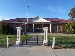
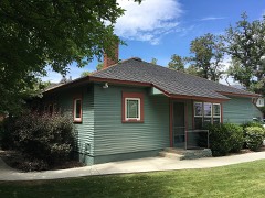
Photograph of Douglas County High School
Photograph by Jennifer Cooper, CC BY-SA 3.0. Via Wikimedia Commons.

Douglas County High School

Built in 1915 (Neoclassical architecture). Listed on the National Register of Historic Places in 1992.

From the record

“Douglas County High School was the high school serving Douglas County, Nevada from 1915 to the mid-1950s when it became a middle school. In 1988, the building was retired from educational uses.”

Wikipedia article Douglas County High School (Nevada), CC BY-SA 4.0.

One of 24 National Register listings published here for Douglas County · listed in 1992 · category: Building · built in 1915, Neoclassical architecture, by Frederic Joseph DeLongchamps.

Sources: the Wikipedia article · the case file at the National Archives · the National Register database, National Park Service
The listing

  • Address. 1477 US 395, Gardnerville, 89410
  • When was it listed? March 1992
  • Category. building
  • Also known as. Architecture of Frederick J. DeLongchamps TR
  • Census division. Gardnerville-Minden
  • When was it built? 1915
  • Architectural style. Neoclassical architecture
  • Architect. Frederic Joseph DeLongchamps
  • National Register reference number. 92000117 - the number the National Park Service assigned this property when it was listed, and the key its nomination file is catalogued under at the National Archives.

Fires near this property

27 since 1992

Regional context, not property-specific evidence. The federal wildfire occurrence database lists 27 fires within 5 miles of Douglas County High School between 1992 and 2020, burning about 32 acres in total. 6 started naturally. 1 was recorded as arson. Distance is straight-line from the map coordinates, so a fire counted here may appear on a neighbouring settlement's page as well.

Reported cause Fires
Natural6
Equipment and vehicle use5
Missing data/not specified/undetermined5
Debris and open burning4
Misuse of fire by a minor3
Firearms and explosives use2
Arson/incendiarism1
Recreation and ceremony1

The most recent of them, most recent first, with the day each was reported and the service that recorded it.

DateCause SizeReported by Name on the report
13 September 2009Missing data/not specified/undeterminedunder an acreHumboldt-Toiyabe National ForestPIT
4 August 1999Naturalunder an acreCarson City District OfficeWINDMILL
3 August 2006Equipment and vehicle useunder an acreHumboldt-Toiyabe National ForestTILLMAN
29 August 2017Missing data/not specified/undeterminedunder an acreEast Fork Fire and Paramedic District88
23 August 2018Missing data/not specified/undetermined9.0 acresCarson City District OfficeRANCH
31 July 1995Debris and open burningunder an acreCarson City District OfficeBIA 12
26 July 1997Naturalunder an acreHumboldt-Toiyabe National ForestLOWER ROAD
21 July 1994Recreation and ceremonyunder an acreCarson City District OfficeBAKER

Every fire recorded in Douglas County

Mines and quarries near this property

8 within 5 miles

Regional context, not property-specific evidence. The federal mineral resources record lists 8 workings within 5 miles of Douglas County High School: 5 past producers, 3 producers. 3 still produce. What was taken out: Sand and Gravel, Construction, Stone, Crushed/Broken. Distance is straight-line from the map coordinates, so a quarry counted here may appear on a neighbouring settlement's page as well.

Where SiteCommodity StatusRecorded
Environmental Community BLM PitStone, Crushed/BrokenPast Producer
Sawmill PitStone, Crushed/BrokenProducer
Bing Materials Pit & PlantSand and Gravel, ConstructionProducer
Dresslerville PitSand and Gravel, ConstructionProducer
Johnson Genoa PitSand and Gravel, ConstructionPast Producer
Nev. Contractors Sand & Gravel PitSand and Gravel, ConstructionPast Producer
Rancho PitSand and Gravel, ConstructionPast Producer
Settelmeyer Sand & Gravel PitSand and Gravel, ConstructionPast Producer

Every working recorded in Douglas County

Storms near this property

27 since 1998

Regional context, not property-specific evidence. The National Weather Service names Gardnerville, the town this property stands in, in 27 storm reports between 1998 and 2025: 14 heavy rain, 6 flash flood, 3 lightning, 2 thunderstorm wind. The reports record 1 injury. Each account below is quoted exactly as the forecast office filed it, from the NOAA Storm Events Database, and each date opens the federal record of that event.

WhenEvent Place namedHarm What the report says
August 2004LightningGardnerville1 hurtA 12-year-old girl was struck by lightning in Gardnerville during the afternoon of the 12th. The condition of the girl was not known at the time of the report.
August 2014Flash FloodGardnerville$50,000The Minden-Gardnerville Record Courier noted that a Douglas County fire marshal stated that 9 houses had interior damage due to flooding. Also, emergency officials indicated that 2 feet of water had flowed over Fish Springs Rd. A power pole was broken near Jacobsen Ln due to the flash flood.
August 2005LightningGardnerville$15,000Lightning struck the roof of a house in Gardnerville, starting a fire in the attic. Lightning also caused power outages in Gardnerville and Minden. Up to 2,100 people were temporarily without power as a result.
June 2015Flash FloodGardnerville$5,000The Douglas County Emergency Manager reported flash flooding impacts near low water crossings along Sawmill and Arroyo Roads.
February 2025Heavy RainGardnerville-CoCORAHS (NV-DG-4 Gardnerville) located 3.0 ESE of Heavenly Valley, NV, reported a 24 hour storm total rainfall amount of 1.59 inches.
July 2024Heavy RainGardnerville-A Cocorahs station (NV-DG-11- Gardnerville) located 3.9 S of Gardnerville, NV, reported a total rainfall amount of 0.60 inches.
December 2024Heavy RainGardnerville-A trained spotter located 4.0 mi W of Gardnerville Ranch, NV, reported 24 hour storm total rainfall of 0.54 inches.
November 2024Heavy RainGardnerville-CoCORAHS (NV-DG-23 Gardnerville) located 5.7 miles W of Gardnerville, NV, reported 24 hour storm total rainfall of 0.92 inches.
March 2023Heavy RainGardnerville-A COCORAHS (NV-DG-23 Gardnerville) located 5.7 mi W of Gardnerville, NV, reported a 24-hour rainfall total of 2.27 inches.
March 2023Heavy RainGardnerville-A COCORAHS (NV-DG-11 Gardnerville) located 3.9 mi S of Gardnerville, NV, and a CO-OP Observer (MINN2) located in Minden, NV, reported 24-hour rainfall totals of 1.78 and 1.52 inches respectively.
June 2023Heavy RainGardnerville-A mesonet station (FISN2-Fish Springs) located 5.0 mi ESE of Gardnerville, NV, reported a total rainfall amount of 0.96 inches.
July 2021Flash FloodGardnerville-Spotter reported 4-6 inches of water running where Fish Springs and Jacobsen Lane meet. Nearby Pine Nut Creek full due to runoff on the Numbers Fire burn scar.
November 2021Heavy RainGardnerville-Trained spotter 3 mi WSW of Gardnerville Ranchos reported 0.81 inches of rainfall measured in 12 hour period.
December 2021Heavy RainGardnerville-Trained spotter reported 1.13 of heavy rain.
March 2019Heavy RainGardnerville-CoCoRaHS station NV-DG-4 in 5 miles west of Gardnerville reported 0.75 inches of rainfall in a 24 hour period from 27 March 0600PST to 28 March 0600PST.
December 2018Heavy RainGardnerville-Trained weather spotter 3 miles west-southwest of Gardnerville Ranchos reported 0.87 inches of rainfall in a 24-hour period from 24 December 0807PST to 25 December 0807PST.
March 2018Heavy RainGardnerville-CoCoRaHS station NV-DG-11, Gardnerville reported 2.33 inches of storm total rainfall from 20 March 0520PST to 23 March 0520PST.
May 2018Heavy RainGardnerville-Mesonet station PNTN2, 9 miles east of Gardnerville (elevation 5882 feet) reported 0.63 inches of rainfall in a 24-hour period from 24 May 0858PST to 25 May 0858PST.
July 2015Flash FloodGardnerville-Facebook videos from a National Weather Service employee and KOLO News showed fast flowing water in Pine Nut Creek and over low water crossings on Cali Pequeno and Out-R-Way Roads.
August 2014Flash FloodGardnerville-Flood waters from Pine Nut Creek moved over East Valley Rd (and several non-paved roads) per photographic evidence. The Allerman Canal (eastern side of Gardnerville) helped to stop the advance of flood waters. The time of the flash flood is estimated.
May 2009HailGardnerville-A trained weather spotter reported 1-inch diameter hail 3 miles SSW of Gardnerville.
April 2005LightningGardnerville-Lightning struck a poplar tree at a home in Gardnerville. The lightning bolt blew out the front door jamb of the house. An automobile's windshield was badly cracked. Computers, televisions, and VCRs throughout the neighborhood were damaged from the strike. In a house a few doors away, kitchen lights were blown from their sockets.
August 2002Heavy RainGardnerville-1 inch of rain in 85 minutes
September 1998Flash FloodGardnerville-Mud covering one side of Fish Springs Road. Reported by Douglas County Sheriff.
July 2014Thunderstorm WindGardnerville-no account filed
July 2005HailGardnerville-no account filed
July 2002Thunderstorm WindGardnerville-no account filed

Every storm recorded in Douglas County

Map coverage status

No historic map-sheet match is published for this property yet. That does not mean no map exists. This record needs a coordinate-quality review before it can be joined to a sheet boundary. Browse the county's mapped places while that work is pending.

Listed places nearby

6 within 8 miles

Other National Register properties close enough to walk or drive between, ordered by distance from this one. Both positions come from the same geocoding pass that matched these properties to their map sheets.

Photograph PropertyDistance Listed
Carson Valley Hospitalunder 500 feet1979
Arendt Jensen Jr. House0.3 miles1994
Gardnerville Elementary School0.5 miles2008
Gardnerville Branch Jail0.5 miles2003
Arendt Jensen House0.5 miles1989
Wilhelm and William Lampe Ranch0.7 miles

Sources for this property

National Archives recordThe nomination case file for reference 92000117 in Record Group 79.
Wikipedia articleCommunity-written account of this property, licensed CC BY-SA.
Douglas CountyAll 24 listed properties in this county.

Provenance

  • Listing record. National Park Service National Register of Historic Places, listed-properties dataset, current to 2026-05-22.
  • Map join. Address geocoded through the United States Census geocoder, then tested against the published boundary of every sheet in the USGS Historical Topographic Map Collection.
  • How this page is made. Listing fields come from federal records; map-sheet coverage is a labelled coordinate-to-boundary calculation, not a source-field claim.
  • Wildfire. Short, Karen C. 2022. Spatial wildfire occurrence data for the United States, 1992-2020 [FPA_FOD_20221014]. 6th Edition. Fort Collins, CO: Forest Service Research Data Archive. https://doi.org/10.2737/RDS-2013-0009.6 Collected with United States Government funding and usable without additional permissions or fees.
  • Mines and quarries. USGS Mineral Resources Data System (MRDS) https://mrdata.usgs.gov/mrds/ A work of the United States government, no copyright under 17 U.S.C. 105.
  • Storms. NOAA National Centers for Environmental Information, Storm Events Database https://www.ncei.noaa.gov/stormevents/ A work of the United States government, no copyright under 17 U.S.C. 105. Narratives are quoted verbatim from the National Weather Service report and are not edited or summarised.