Block
BlockFrom the record
One of 79 National Register listings published here for Otsego County · listed in 1982 · category: District.
Sources: the case file at the National Archives · the National Register database, National Park Service
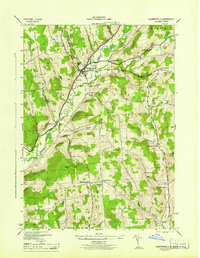
Listed on the National Register of Historic Places in 1982. 9 historic topographic surveys show this location, the earliest from 1915.
One of 79 National Register listings published here for Otsego County · listed in 1982 · category: District.
Sources: the case file at the National Archives · the National Register database, National Park Service
Regional context, not property-specific evidence. The federal wildfire occurrence database lists 29 fires within 5 miles of Gilbertsville Historic District (Boundary Increase) between 1995 and 2018, burning about 24 acres in total. 3 started naturally. 1 was recorded as arson. Distance is straight-line from the map coordinates, so a fire counted here may appear on a neighbouring settlement's page as well.
| Reported cause | Fires |
|---|---|
| Missing data/not specified/undetermined | 17 |
| Debris and open burning | 4 |
| Natural | 3 |
| Power generation/transmission/distribution | 2 |
| Smoking | 1 |
| Arson/incendiarism | 1 |
| Equipment and vehicle use | 1 |
The most recent of them, most recent first, with the day each was reported and the service that recorded it.
| Date | Cause | Size | Reported by | Name on the report |
|---|---|---|---|---|
| 25 September 2007 | Missing data/not specified/undetermined | under an acre | Fire Department of New York | not named |
| 15 August 2007 | Missing data/not specified/undetermined | 1.0 acres | Fire Department of New York | not named |
| 1 July 2018 | Debris and open burning | under an acre | Fire Department of New York | N/A |
| 6 May 2013 | Missing data/not specified/undetermined | under an acre | Fire Department of New York | N/A |
| 4 May 2006 | Missing data/not specified/undetermined | under an acre | Fire Department of New York | not named |
| 28 April 2009 | Missing data/not specified/undetermined | under an acre | Fire Department of New York | not named |
| 23 April 2007 | Missing data/not specified/undetermined | 1.2 acres | Fire Department of New York | not named |
| 21 April 2008 | Missing data/not specified/undetermined | 1.7 acres | Fire Department of New York | not named |
Regional context, not property-specific evidence. The federal mineral resources record lists 2 workings within 5 miles of Gilbertsville Historic District (Boundary Increase): 2 past producers. None of them still produces. What was taken out: Sand and Gravel, Construction. Distance is straight-line from the map coordinates, so a quarry counted here may appear on a neighbouring settlement's page as well.
| Where | Site | Commodity | Status | Recorded |
|---|---|---|---|---|
| Number 17 Pit | Sand and Gravel, Construction | Past Producer | ||
| Plant Number 17 | Sand and Gravel, Construction | Past Producer | Sedimentary |
Regional context, not property-specific evidence. The National Weather Service names Gilbertsville, the town this property stands in, in 29 storm reports between 1994 and 2025: 18 thunderstorm wind, 5 flash flood, 5 hail, 1 tornado. No death or injury is recorded in these reports. Each account below is quoted exactly as the forecast office filed it, from the NOAA Storm Events Database, and each date opens the federal record of that event.
| When | Event | Place named | Harm | What the report says |
|---|---|---|---|---|
| April 2011 | Flash Flood | Gilbertsville | $1,000,000 | Scattered roads were washed out and floods were reported throughout the county. |
| June 2025 | Flash Flood | Gilbertsville | $100,000 | Numerous roads, bridges, and homes were flooded in and around the village. |
| April 2011 | Tornado (EF1) | Gilbertsville | $100,000 | A tornado touched down in woods near Route 51 between Mount Upton and Gilbertsville, producing EF0 damage until reaching Copes Corners Road where it strengthened to EF1, snapping and uprooting trees through a heavily wooded area. It moved up the hill and across the athletic fields of the Gilbertsville-Mount Upton Central School. Here, it threw metal bleachers several hundred yards to the north. It also tore a press box off steel beams, hurled a railroad tie used in a parking lot over a hundred feet into a fence, broke off metal poles used for hanging netting, and bent a soccer goal back in the southward direction. The field was littered with small tree missiles pointing in both directions with a southward direction on the left side of the path. A portable toilet was lifted and dropped about a half mile away and some other light material was found almost a mile away. The tornado continued to the northeast passing south of Gilbertsville, with damage primarily to trees. The path continued to narrow and weaken, ending a couple miles east of Gilbertsville. |
| July 1997 | Thunderstorm Wind | Gilbertsville | $50,000 | The same severe thunderstorm that produced widespread wind damage in northern Broome and southern Chenango counties ripped through southern Otsego county. Again, wind damage was the main story. To the southwest of Gilbertsville, trees and wires were blown down across Route 18. Further to the east, many additional trees and utility poles were toppled in both Otego and Oneonta. |
| July 1995 | Thunderstorm Wind | Gilbertsville | $20,000 | no account filed |
| July 2021 | Flash Flood | Gilbertsville | $15,000 | Numerous roads were reported as washed out in the area, including State Route 8. |
| July 2024 | Thunderstorm Wind | Gilbertsville | $7,500 | Strong thunderstorm winds knocked down or snapped approximately 15 trees. |
| July 2022 | Thunderstorm Wind | Gilbertsville | $5,000 | Strong thunderstorm winds knocked down multiple trees in Gilbertsville. |
| September 2018 | Flash Flood | Gilbertsville | $5,000 | Water was flowing across County Road 4 near Mill Street. |
| September 2013 | Thunderstorm Wind | Gilbertsville | $5,000 | Trees were blown down across the Town of Butternuts. |
| April 2011 | Thunderstorm Wind | Gilbertsville | $5,000 | Trees were blown down in Gilbertsville. |
| June 2005 | Thunderstorm Wind | Gilbertsville | $5,000 | Thunderstorm winds downed numerous trees. |
| March 2005 | Flash Flood | Gilbertsville | $5,000 | no account filed |
| July 1994 | Thunderstorm Wind | Gilbertsville | $5,000 | no account filed |
| May 2017 | Thunderstorm Wind | Gilbertsville | $3,000 | A thunderstorm moved across the region and became severe. This thunderstorm produced damaging winds. |
| July 2024 | Thunderstorm Wind | Gilbertsville | $2,500 | Strong thunderstorm winds knocked down trees along Reservoir Road. |
| September 2021 | Thunderstorm Wind | Gilbertsville | $2,000 | Strong thunderstorm winds knocked down a tree and wires down. |
| November 2005 | Thunderstorm Wind | Gilbertsville | $2,000 | Thunderstorm winds downed isolated trees and wires. |
| June 2025 | Thunderstorm Wind | Gilbertsville | $1,000 | Strong thunderstorm winds knocked down a tree on Town Line Road. |
| September 2023 | Thunderstorm Wind | Gilbertsville | $1,000 | Strong thunderstorm winds knocked down a tree onto the road. |
| July 2021 | Thunderstorm Wind | Gilbertsville | $1,000 | Strong thunderstorm winds knocked down a tree onto Oregon Rd, blocking most of the roadway. |
| August 2016 | Thunderstorm Wind | Gilbertsville | - | A thunderstorm moved across the region and became severe. This thunderstorm resulted in a large branch being knocked down. |
| October 2013 | Thunderstorm Wind | Gilbertsville | - | A tree was blown down. |
| August 2007 | Thunderstorm Wind | Gilbertsville | - | Several trees up to 2 feet in diameter were blown down. |
| May 2014 | Hail | Gilbertsville | - | no account filed |
| June 2011 | Hail | Gilbertsville | - | no account filed |
| June 2008 | Hail | Gilbertsville | - | no account filed |
| June 2007 | Hail | Gilbertsville | - | no account filed |
| June 2007 | Hail | Gilbertsville | - | no account filed |
United States Geological Survey topographic sheets whose coverage includes this point. Matched by taking the middle of the area the National Park Service maps for this listing, then testing that coordinate against the published boundary of every sheet.
Other National Register properties close enough to walk or drive between, ordered by distance from this one. Both positions come from the same geocoding pass that matched these properties to their map sheets.
| Photograph | Property | Distance | Listed |
|---|---|---|---|
| Gilbertsville Historic District | 0.2 miles | 1974 | |
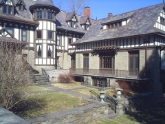 | Major's Inn and Gilbert Block | 0.2 miles | 1973 |
| Tianderah | 0.6 miles | 1978 | |
| Gilbertsville Water Works | 1.6 miles | 2011 | |
| All Saints Chapel and Morris Family Burial Ground | 3.3 miles | 1997 | |
| St. Stephen's Chapel | 4.3 miles | 2021 |
| National Archives record | The nomination case file for reference 82001232 in Record Group 79. |
| Otsego County | All 79 listed properties in this county. |