 Block
Ardmore, Oklahoma
17 topographic sheets cover this place, the earliest surveyed in 1901 and the latest in 1986. It stands in the Ardmore census division. It lies in ZIP code area 73401. The Survey maps it on the Ardmore West quadrangle. 24,725 people lived here at the 2020 count. It stands 873 feet above sea level.
Research this city
On record in Ardmore
Buildings and businesses the archive holds for this place. Each opens its own page, with the source record it came from.
On the National Register 12 of 20 shown
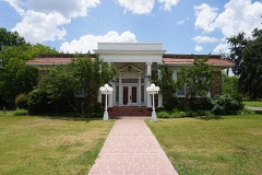 Ardmore Carnegie Librarylisted 2000
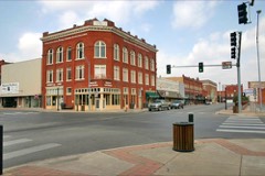 Ardmore Historic Commercial Districtlisted 1983
 Ardmore Municipal Auditoriumlisted 2006
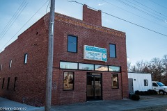 Black Theater of Ardmorelisted 1984
 Carter County Courthouselisted 1985
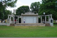 Central Park Bandstandlisted 2006
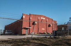 Douglass High School Auditoriumlisted 1984
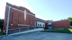 Dunbar Schoollisted 1984
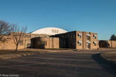 Hardy Murphy Coliseumlisted 2006
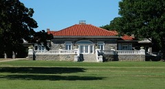 Johnson Homelisted 1986
 Lake Murray State Parklisted 2001
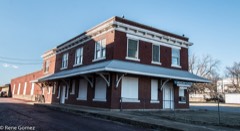 Oklahoma, New Mexico and Pacific Railroad Depotlisted 1982
Population over time
2 figuresArdmore grew from 24,283 to 24,725 between 2010 and 2020. These are the recorded population figures Wikidata holds for this place, reached through the Geographic Names Information System number this page is keyed on rather than by name, so they belong to this place and not to another of the same name. Most are census counts, but not all are: an early figure may be a founding or settlement estimate, and an estimate published within five years of a census is left out. The change column is computed, and is left blank where more than 20 years separate a figure from the one before it, because a gap that long is not a change between two counts.
| Year | People | Change |
|---|---|---|
| 2010 | 24,283 | |
| 2020 | 24,725 | +442 (+2%) |
Topographic sheets covering this place
6 surveys from 17 printed sheetsMatched by testing this settlement's coordinate against the published boundary of every sheet in the United States Geological Survey's historical collection. Each opens the scanned sheet at the Survey.
- 1901 USGS Ardmore quadrangle1:125000, 6 printings
- 1918 USGS Ardmore quadrangle1:125000
- 1957 USGS Ardmore quadrangle1:250000, 3 printings
- 1963 USGS Ardmore quadrangle1:250000, 2 printings
- 1964 USGS Ardmore West quadrangle1:24000, 3 printings
- 1986 USGS Ardmore quadrangle1:100000, 2 printings
Fires near this place
6 since 1996Regional context, not property-specific evidence. The federal wildfire occurrence database lists 6 fires within 5 miles of Ardmore between 1996 and 2008, burning about 41 acres in total. None started naturally. 3 were recorded as arson. Distance is straight-line from the map coordinates, so a fire counted here may appear on a neighbouring settlement's page as well.
| Reported cause | Fires |
|---|---|
| Arson/incendiarism | 3 |
| Debris and open burning | 2 |
| Power generation/transmission/distribution | 1 |
The most recent of them, most recent first, with the day each was reported and the service that recorded it.
| Date | Cause | Size | Reported by | Name on the report |
|---|---|---|---|---|
| 4 August 2006 | Debris and open burning | 10 acres | Chickasaw Agency | HALE |
| 22 July 2006 | Power generation/transmission/distribution | under an acre | Chickasaw Agency | BROCK |
| 3 March 1996 | Arson/incendiarism | 25 acres | Chickasaw Agency | LONEGROVE |
| 14 March 2008 | Arson/incendiarism | 3.5 acres | Chickasaw Agency | EAST END |
| 28 February 2008 | Arson/incendiarism | under an acre | Chickasaw Agency | MORTON RODE |
| 13 January 2008 | Debris and open burning | 1.9 acres | Chickasaw Agency | BRIAR PIT |
Settlements close enough to share some of these fires:
Mines and quarries near this place
10 of 18 shownRegional context, not property-specific evidence. The federal mineral resources record lists 18 workings within 5 miles of Ardmore: 15 past producers, 3 producers. 3 still produce. What was taken out: Stone, Crushed/Broken, Sand and Gravel, Construction, Stone, Crushed/Broken, Sand and Gravel, Construction. Distance is straight-line from the map coordinates, so a quarry counted here may appear on a neighbouring settlement's page as well.
| Where | Site | Commodity | Status | Recorded |
|---|---|---|---|---|
| Unknown Sand Pit | Stone, Crushed/Broken, Sand and Gravel, Construction | Past Producer | ||
| Ardmore Pits | Sand and Gravel, Construction | Producer | ||
| Unknown Gravel | Sand and Gravel, Construction | Past Producer | ||
| Unknown Gravel Pit | Sand and Gravel, Construction | Past Producer | ||
| Unknown Gravel Pit | Sand and Gravel, Construction | Past Producer | ||
| Unknown Gravel Pit | Sand and Gravel, Construction | Past Producer | ||
| Unknown Gravel Pit | Sand and Gravel, Construction | Past Producer | ||
| Unknown Gravel Pit | Sand and Gravel, Construction | Past Producer | ||
| Unknown Sand Pit | Sand and Gravel, Construction | Past Producer | ||
| Ardmore Plant | Stone, Crushed/Broken | Producer |
Storms near this place
60 of 163 shownRegional context, not property-specific evidence. The National Weather Service names Ardmore in 163 storm reports between 1993 and 2026: 71 hail, 68 thunderstorm wind, 16 flash flood, 5 lightning. The reports record 1 death and 21 injuries. Each account below is quoted exactly as the forecast office filed it, from the NOAA Storm Events Database, and each date opens the federal record of that event.
| When | Event | Place named | Harm | What the report says |
|---|---|---|---|---|
| June 2015 | Flash Flood | Ardmore | 1 killed | A two year old boy was swept away from his father's arms into Hickory Creek. |
| April 2024 | Tornado (EF2) | Ardmore | 19 hurt, $20,000,000 | The Ardmore tornado initially developed about 5 miles southwest of Ardmore, and moved north-northeast towards Ardmore. Some homes near Gateway Road had most or all of their roofs removed. Tree damage was significant along this area. ||The tornado then continued north-northeast through the west side of Ardmore especially near Plainview Road. Many homes suffered significant roof damage. Ardmore emergency management reported that 52 homes were damaged with 17 of them a total loss. The tornado moved near a Best Buy distribution center on the northwest side of Ardmore blowing over numerous trailers.||Continuing north-northeast, the tornado continued producing tree and power pole damage, and EF2 roof damage to another home near Lake Ardmore road. The tornado crossed Interstate 35 just east of Ardmore Club Lake and turned more northeast before dissipating near US Highway 77 north of Deer Creek Road. |
| May 1993 | Tornado (F1) | Ardmore - | 1 hurt, $50,000 | no account filed |
| June 1997 | Flash Flood | Ardmore | 1 hurt, $25,000 | Run-off from torrential rain (about 2 inches in 45 minutes) swept two motorists into swift floodwaters and resulted in rapid-water rescues in both of the incidents. In the first incident, a woman driving a mini-van pulled into a parking lot to await the end of the downpour, but was washed by runoff into a nearby, full drainage ditch. The water in the ditch completely submerged the van with the woman trapped inside. She survived by breathing the air that was trapped in a shallow bubble at the ceiling of the van. A police officer, with the help of 2 bystanders, was finally able to break a window and pull her from the van. The woman was treated for shock and hypothermia, but was otherwise uninjured. Her van, valued at $20,000, was totalled.In the second incident, a man driving a car across a flooded low-water bridge was swept into a creek. He escaped from the car and was pulled to shore by nearby residents with a garden hose. Damage to the vehicle was estimated at $5000. |
| June 1996 | Lightning | Ardmore | $100,000 | no account filed |
| May 2015 | Flash Flood | Ardmore | $80,000 | Several vehicles stranded in two to three feet of running water over Commerce Street. |
| May 2001 | Thunderstorm Wind | Ardmore | $50,000 | A tractor-trailer was overturned on Interstate 35 near mile marker 34. The cafeteria at Ardmore High School sustained structural damage. |
| September 1995 | Thunderstorm Wind | Ardmore | $50,000 | Severe thunderstorm winds in Carter County damaged siding and the roofs at a hangar and a water plant at the Ardmore Air Base. Two utility poles were also blown down. |
| May 1993 | Thunderstorm Wind | Ardmore | $50,000 | no account filed |
| May 2000 | Thunderstorm Wind | Ardmore | $30,000 | Power lines were downed. One mobile home was destroyed. Trees were felled onto vehicles, and a rig was blown over at Uniroyal Tire Plant. |
| May 2000 | Thunderstorm Wind | Ardmore | $25,000 | The roof was damaged at Southern Oklahoma Tech Center. |
| June 2018 | Thunderstorm Wind | Ardmore | $20,000 | Two semi-trailers were blown over and a roof was partially torn off a building. Time estimated by radar. |
| June 2015 | Flash Flood | Ardmore | $20,000 | At least one foot of flowing water on some roadways. One car stalled out near Commerce and 6th street. |
| May 2015 | Flash Flood | Ardmore | $20,000 | Car stalled in high water due to heavy rainfall. |
| June 2025 | Thunderstorm Wind | Ardmore | $15,000 | Trees and power lines were blown down on the northwest side of the community of Ardmore. The location is approximate, and the event time is estimated from radar observations. |
| May 2008 | Thunderstorm Wind | Ardmore | $15,000 | Numerous tree limbs and power lines were downed by the strong winds. A few buildings in the downtown Ardmore area had windows blown out, including a few windows at the Daily Ardmorite newspaper. The metal roof at Parkway Storage was severely damaged. A storage shed was also severely damaged. Monetary damages were estimated. |
| May 2001 | Thunderstorm Wind | Ardmore | $15,000 | Metal roof at Days Inn was damaged. |
| June 2023 | Thunderstorm Wind | Ardmore | $10,000 | Tree blown down, landing on a mobile home. Time is radar estimated. |
| June 2023 | Thunderstorm Wind | Ardmore | $10,000 | Roof damage to a large warehouse. Thirty-nine air vents were removed from the roofing structure which lead to extensive water damage inside the warehouse. Time is radar estimated. |
| October 2023 | Flash Flood | Ardmore | $10,000 | Report of several feet of water on roadways with multiple vehicles stalled in the city of Ardmore. Time is estimated. |
| June 2018 | Thunderstorm Wind | Ardmore | $10,000 | Two semi-trailers were blown over and a roof was partially torn off a building. Time estimated by radar. |
| April 2016 | Thunderstorm Wind | Ardmore | $10,000 | A garage was totaled. |
| June 1997 | Thunderstorm Wind | Ardmore | $10,000 | Severe thunderstorm winds at the downtown airport broke one plane from its tie-downs and blew it into 2 others, damaging all three aircraft. |
| April 1999 | Thunderstorm Wind | Ardmore | $10,000 | no account filed |
| May 1997 | Lightning | Ardmore | $8,000 | Lightning struck and set fire to a vacant house. Damage was estimated at $8000. |
| June 2005 | Thunderstorm Wind | Ardmore | $7,500 | One end of a barn was blown out. |
| February 2023 | Thunderstorm Wind | Ardmore | $5,000 | A sheet metal roof was removed from an outbuilding. Time was estimated via radar. |
| July 2009 | Thunderstorm Wind | Ardmore | $5,000 | Numerous limbs were downed by strong winds. A tin barn was also destroyed. The time and location were estimated. Monetary damages were also estimated. |
| December 2002 | Lightning | Ardmore | $5,000 | Lightning struck a tank battery. |
| September 1996 | Thunderstorm Wind | Ardmore | $5,000 | no account filed |
| May 1994 | Thunderstorm Wind | Ardmore | $5,000 | no account filed |
| May 1994 | Thunderstorm Wind | Ardmore | $5,000 | no account filed |
| July 1994 | Thunderstorm Wind | Ardmore | $5,000 | no account filed |
| November 2015 | Thunderstorm Wind | Ardmore | $4,000 | Winds snapped large branches, snapped a small tree, blew down a wooden fence, and caused some minor roof damage (lifting of shingles). |
| September 2012 | Thunderstorm Wind | Ardmore | $3,000 | Storm chaser reported trees uprooted at the intersection of US-70 and Mayall road on the west side of Ardmore. |
| January 1996 | Thunderstorm Wind | Ardmore | $3,000 | no account filed |
| February 2001 | Thunderstorm Wind | Ardmore | $2,000 | A roof was damaged. |
| May 2001 | Thunderstorm Wind | Ardmore | $2,000 | Power poles were snapped. |
| April 1998 | Thunderstorm Wind | Ardmore | $2,000 | Numerous tree limbs and power lines were downed by severe thunderstorm winds. A carport was also damaged. |
| May 1997 | Lightning | Ardmore | $1,500 | Lightning struck and set fire to a storage shed. |
| August 2002 | Thunderstorm Wind | Ardmore | $1,000 | Trees and power lines were downed. |
| June 2005 | Thunderstorm Wind | Ardmore | $500 | Tree limbs, four inches in diameter, were downed. |
| March 2006 | Thunderstorm Wind | Ardmore | $250 | A traffic sign was blown down. |
| October 2011 | Thunderstorm Wind | Ardmore | $100 | Two 8 to 10 inch diameter trees were blown down. |
| March 2026 | Thunderstorm Wind | Ardmore | - | Ardmore (ARD2) Mesonet observation. |
| April 2026 | Hail | Ardmore | - | The location is approximate. |
| April 2026 | Hail | Ardmore | - | The report was relayed through mPING. |
| April 2026 | Flash Flood | Ardmore | - | Significant roadway flooding, with an estimated water depth of one foot, near the intersection of Broadway Street and Wheeler Street. The event time is estimated. |
| April 2026 | Hail | Ardmore | - | The report was relayed through mPING. The event time was adjusted based on radar observations. |
| May 2025 | Hail | Ardmore | - | The report was relayed through mPING. |
| May 2025 | Hail | Ardmore | - | The report was relayed through mPING. |
| May 2025 | Hail | Ardmore | - | The location is approximate. |
| April 2025 | Thunderstorm Wind | Ardmore | - | Estimated wind gust. Location is approximate. |
| April 2025 | Hail | Ardmore | - | The report was relayed through mPING. |
| April 2025 | Flash Flood | Ardmore | - | Multiple confirmations from emergency management and the public of flash flooding in and around the community of Ardmore. This included at least one water rescue. Event time is approximate. |
| April 2024 | Tornado (EF0) | Ardmore | - | A brief tornado produced some light tree damage about 4 miles northeast of Ardmore. |
| May 2024 | Hail | Ardmore | - | MPing report. |
| June 2023 | Thunderstorm Wind | Ardmore | - | Semi-trailer blown over on Interstate 35 near mile marker 32. Time is radar estimated. |
| June 2023 | Hail | Ardmore | - | MPing report. |
| June 2023 | Hail | Ardmore | - | MPing report. Based on radar evidence, hailfall likely occurred prior (2315-2320 LST) to report. |
Newspapers printed here
67,829 digitised pages1 paper published in this town, digitised by the Library of Congress and free to read: 8,738 issues, 67,829 pages. Every page is searchable, so a name or a street can be looked for directly in what the town printed about itself at the time.
| Newspaper | Published |
|---|---|
| The Daily Ardmoreite | 1893 to Current |
What the paper printed
14,287 wordsFront pages of the local paper, read from the Library of Congress scans: 4 issues spread across its run from 1893 to 1922, 14,287 words in total. Each is reproduced on its own page, exactly as the recogniser returned it.
These pages read less well than anything else here, and the number is worth stating: about three words in four come through cleanly, against nine in ten for the building records. An 1896 broadsheet sets eight-point type in seven columns on microfilm, which is the hardest thing in this archive to read by machine. We tested our own recognisers against the Library's and they were not better, so the Library's text is what appears, with the wholly unreadable columns removed. Read it as a guide to what the paper covered, and follow the link to the scan before quoting anything.
| Issue | Paper | Length |
|---|---|---|
| 1893-10-29 | The Daily Ardmoreite | 4,700 words |
| 1893-11-12 | The Daily Ardmoreite | 3,476 words |
| 1893-12-11 | The Daily Ardmoreite | 1,505 words |
| 1922-12-31 | The Daily Ardmoreite | 4,606 words |
Nearest settlements
The eight closest, with where each one stands in the county. Distances are straight-line, computed from the Geographic Names Information System coordinates.
| Map | Place | Distance | Sheets |
|---|---|---|---|
| Dripping Springs | 5.6 miles | 18 | |
| Lone Grove | 6.3 miles | 16 | |
| Brock | 6.5 miles | 17 | |
| Provence | 6.7 miles | 18 | |
| Caldwell Hill | 6.8 miles | 18 | |
| Dickson | 8.5 miles | 14 | |
| Newport | 8.8 miles | 15 | |
| Gene Autry | 9.4 miles | 17 |
Elsewhere
Matched on this settlement's Geographic Names Information System number rather than its name, so it cannot be a different place of the same name in another state.
| Wikipedia article on Ardmore | An encyclopaedic summary. Its text is share-alike, so it is linked here rather than copied. |
| Wikidata item Q639640 | The structured record the population and elevation above come from. Public domain (CC0). |
Provenance
This settlement is recorded in the Geographic Names Information System as feature 1089691. The sheet list is computed by point-in-boundary test against the United States Geological Survey's historical topographic inventory. Both are works of the United States government and carry no copyright under 17 U.S.C. 105.
Wildfire. Short, Karen C. 2022. Spatial wildfire occurrence data for the United States, 1992-2020 [FPA_FOD_20221014]. 6th Edition. Fort Collins, CO: Forest Service Research Data Archive. https://doi.org/10.2737/RDS-2013-0009.6 Collected with United States Government funding and usable without additional permissions or fees.
Mines and quarries. USGS Mineral Resources Data System (MRDS) https://mrdata.usgs.gov/mrds/ A work of the United States government, no copyright under 17 U.S.C. 105.
Storms. NOAA National Centers for Environmental Information, Storm Events Database https://www.ncei.noaa.gov/stormevents/ A work of the United States government, no copyright under 17 U.S.C. 105. Narratives are quoted verbatim from the National Weather Service report and are not edited or summarised.