 Block
Fairfax, Oklahoma
13 topographic sheets cover this place, the earliest surveyed in 1932 and the latest in 1985. It stands in the Fairfax census division. It lies in ZIP code area 74637. It lies near Threemile Canyon. The Survey maps it on the Fairfax quadrangle. 1,136 people lived here at the 2020 count. It stands 853 feet above sea level.
On record in Fairfax
Buildings and businesses the archive holds for this place. Each opens its own page, with the source record it came from.
On the National Register 4 records
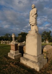 Chief Ne-Kah-Wah-She-Tun-Kah Grave and Statuelisted 1979
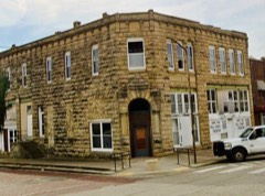 Osage Bank of Fairfaxlisted 1984
- First National Bank and Masonic Lodgelisted 1984
- Lincoln Colored Schoollisted 2003
Population over time
2 figuresFairfax fell from 1,380 to 1,136 between 2010 and 2020. These are the recorded population figures Wikidata holds for this place, reached through the Geographic Names Information System number this page is keyed on rather than by name, so they belong to this place and not to another of the same name. Most are census counts, but not all are: an early figure may be a founding or settlement estimate, and an estimate published within five years of a census is left out. The change column is computed, and is left blank where more than 20 years separate a figure from the one before it, because a gap that long is not a change between two counts.
| Year | People | Change |
|---|---|---|
| 2010 | 1,380 | |
| 2020 | 1,136 | -244 (-18%) |
Topographic sheets covering this place
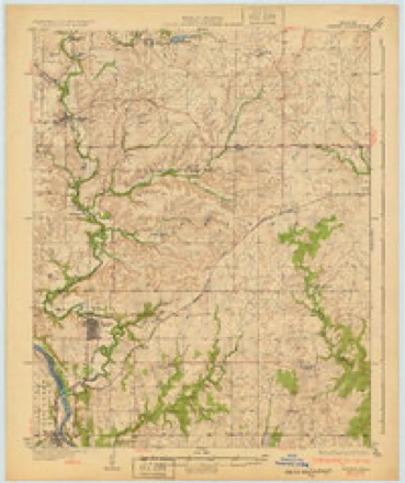
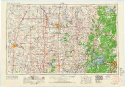
5 surveys from 13 printed sheetsMatched by testing this settlement's coordinate against the published boundary of every sheet in the United States Geological Survey's historical collection. Each opens the scanned sheet at the Survey.
- 1932 USGS Fairfax quadrangle1:62500, 4 printings
- 1955 USGS Enid quadrangle1:250000, 4 printings
- 1958 USGS Enid quadrangle1:250000, 2 printings
- 1978 USGS Fairfax quadrangle1:24000
- 1985 USGS Pawhuska quadrangle1:100000, 2 printings
Fires near this place
85 since 1999Regional context, not property-specific evidence. The federal wildfire occurrence database lists 85 fires within 5 miles of Fairfax between 1999 and 2020, burning about 17,576 acres in total. 8 started naturally. 12 were recorded as arson. Distance is straight-line from the map coordinates, so a fire counted here may appear on a neighbouring settlement's page as well.
| Reported cause | Fires |
|---|---|
| Debris and open burning | 26 |
| Missing data/not specified/undetermined | 14 |
| Equipment and vehicle use | 14 |
| Arson/incendiarism | 12 |
| Natural | 8 |
| Power generation/transmission/distribution | 7 |
| Other causes | 3 |
| Fireworks | 1 |
The most recent of them, most recent first, with the day each was reported and the service that recorded it.
| Date | Cause | Size | Reported by | Name on the report |
|---|---|---|---|---|
| 8 September 2009 | Natural | under an acre | Osage Agency | BENNIE |
| 5 September 2017 | Equipment and vehicle use | under an acre | Osage Agency | WEST MASON |
| 23 September 2008 | Arson/incendiarism | 1.5 acres | Osage Agency | HARP |
| 21 September 2000 | Arson/incendiarism | 3,640 acres | Osage Agency | WILD CREEK |
| 14 September 2011 | Arson/incendiarism | 28 acres | Osage Agency | NEWALLA |
| 10 September 2014 | Debris and open burning | under an acre | Osage Agency | OLD SCHOOL |
| 4 August 2010 | Debris and open burning | 2.5 acres | Osage Agency | HOLLOWAY |
| 10 August 2011 | Natural | 11 acres | Osage Agency | BOWMAN |
Settlements close enough to share some of these fires:
Mines and quarries near this place
6 within 5 milesRegional context, not property-specific evidence. The federal mineral resources record lists 6 workings within 5 miles of Fairfax: 5 past producers, 1 producer. 1 still produces. What was taken out: Stone, Crushed/Broken, Sand and Gravel, Construction. Distance is straight-line from the map coordinates, so a quarry counted here may appear on a neighbouring settlement's page as well.
| Where | Site | Commodity | Status | Recorded |
|---|---|---|---|---|
| Ralston Pit | Sand and Gravel, Construction | Producer | ||
| Unknown Limestone Quarry | Stone, Crushed/Broken | Past Producer | ||
| Unknown Limestone Quarry | Stone, Crushed/Broken | Past Producer | ||
| Unknown Limestone Quarry | Stone, Crushed/Broken | Past Producer | ||
| Unknown Limestone Quarry | Stone, Crushed/Broken | Past Producer | ||
| Unknown Limestone Quarry | Stone, Crushed/Broken | Past Producer |
Storms near this place
60 of 66 shownRegional context, not property-specific evidence. The National Weather Service names Fairfax in 66 storm reports between 1996 and 2020: 29 hail, 26 thunderstorm wind, 8 tornado, 3 flash flood. No death or injury is recorded in these reports. Each account below is quoted exactly as the forecast office filed it, from the NOAA Storm Events Database, and each date opens the federal record of that event.
| When | Event | Place named | Harm | What the report says |
|---|---|---|---|---|
| May 2003 | Tornado (F3) | Fairfax | $250,000 | A F3 tornado touched down northwest of Fairfax and traveled northeast across rural areas of Osage county before dissipating just west of Bowring. The one community it did effect was Little Chief.Oil tanks southwest of Little Chief were taken off their foundation and rolled a quarter of a mile. In Little Chief a RV was destroyed and there was considerable tree damage. In a field not far from Little Chief seven cattle were killed. Along Highway 60 to the northeast of Little Chief a house and garage were completely swept from their foundation. At the same location a barn was destroyed and three horses were killed. Further to the northeast as the tornado entered the Tall Grass Prairie Preserve, it produced additional significant tree damage. Throughout the path of the tornado up to 30 power poles were blown down causing power outages across a significant part of Osage county. The F3 damage was classified at two locations: the first was near where the cattle were killed--this was the only location that showed the scouring of grasses along the path; the second location was in the western sections of the Tall Grass Prairie Reserve where an Oak Forest was heavily damaged. Although the one house was swept off its foundation, it was clear that this house's anchoring failed prematurely. On this property there were several examples, especially with vegetation, that hinted that this stretch of the tornado track was probably less than F3 intensity. |
| May 2008 | Tornado (EF1) | Fairfax | $75,000 | A tornado damaged the roofs of two homes, caused extensive tree damage, and blew down several power poles. This tornado was observed by several storm chasers. |
| October 2018 | Tornado (EF0) | Fairfax | $50,000 | This tornado developed over the southwestern portion of the town of Fairfax, where the roofs of homes were damaged, and power poles and large tree limbs were snapped. The tornado moved northeast across town damaging the roofs of a number of businesses, damaging homes, snapping large tree limbs, and blowing down power poles. Numerous windows of businesses and homes were broken due to flying debris. The tornado moved east-northeast from Fairfax, crossing County Road 5701 where large tree limbs were snapped, then dissipated over open country. Based on this damage, maximum estimated wind in the tornado was 80 to 85 mph. |
| May 2010 | Tornado (EF1) | Fairfax | $50,000 | A tornado that developed over northeastern Noble County continued into western Osage County, where it damaged several homes, uprooted or snapped numerous trees, and blew down power poles. The estimated peak wind in the tornado based on this damage was 110 mph. |
| August 1999 | Thunderstorm Wind | Fairfax | $40,000 | Strong winds caused significant damage in Fairfax. Large trees and power lines were blown down, blocking several streets to traffic. Several buildings suffered structural damage in the form of blown-out windows and roof damage. At a motel in Fairfax, a 600-pound piece of steel was blown from a nearby storage yard into the corner of the motel, lodging itself under the corner of the roof and lifting the roof from the building. A nearby carport was destroyed. Windows in several businesses on the west side of Main Street had their windows blown out, |
| May 2018 | Thunderstorm Wind | Fairfax | $25,000 | Strong thunderstorm wind damaged the roofs of businesses, damaged the high school, and blew down trees and power lines. |
| July 2005 | Thunderstorm Wind | Fairfax | $15,000 | Thunderstorm winds estimated at 70 miles an hour blew down numerous large trees. One of the trees fell on a home and damaged the roof. |
| May 2018 | Thunderstorm Wind | Fairfax | $10,000 | Strong thunderstorm wind damaged the metal roof of a building and snapped numerous large tree limbs. |
| June 2004 | Thunderstorm Wind | Fairfax | $10,000 | Thunderstorm winds in excess of 70 miles an hour blew down large trees and tree limbs. The combination of the wind, trees falling and hail caused broken windows in homes and cars. |
| July 2002 | Thunderstorm Wind | Fairfax | $5,000 | Thunderstorm winds estimated at 70 miles an hour blew trees and power lines down. |
| June 1998 | Thunderstorm Wind | Fairfax | $5,000 | Several trees were blown down, and 12 power poles were blown down. |
| March 2000 | Thunderstorm Wind | Fairfax | $3,000 | Thunderstorm winds blew down a few power poles near Fairfax. |
| June 2007 | Thunderstorm Wind | Fairfax | $1,000 | Thunderstorm winds estimated at 60 miles an hour blew down power lines. |
| June 1997 | Thunderstorm Wind | Fairfax | $500 | no account filed |
| July 2000 | Thunderstorm Wind | Fairfax | $100 | Thunderstorm winds blew down several large tree limbs. |
| July 1997 | Thunderstorm Wind | Fairfax | $100 | no account filed |
| May 1996 | Thunderstorm Wind | Fairfax | $100 | no account filed |
| July 1996 | Thunderstorm Wind | Fairfax | $100 | no account filed |
| May 2019 | Flash Flood | Fairfax | - | Portions of Highway 18 and Lake Road were flooded and closed north of Fairfax. |
| May 2018 | Thunderstorm Wind | Fairfax | - | Strong thunderstorm wind snapped large tree limbs. |
| August 2018 | Thunderstorm Wind | Fairfax | - | Thunderstorm wind was estimated to 65 mph north of Fairfax. |
| May 2013 | Thunderstorm Wind | Fairfax | - | A large tree was blown down onto a roadway by strong thunderstorm winds. |
| June 2013 | Thunderstorm Wind | Fairfax | - | Strong thunderstorm wind blew down large tree limbs. |
| April 2012 | Thunderstorm Wind | Fairfax | - | Strong thunderstorm wind blew down large tree limbs. |
| April 2012 | Thunderstorm Wind | Fairfax | - | Strong thunderstorm wind blew down several large tree limbs. |
| May 2011 | Tornado (EF0) | Fairfax | - | A brief tornado developed over open country. No damage resulted from the tornado. |
| February 2009 | Flash Flood | Fairfax | - | Heavy rain caused water to flow over numerous county roads. |
| May 2009 | Thunderstorm Wind | Fairfax | - | Thunderstorm winds estimated at 70 miles an hour blew some trees down. |
| May 2006 | Thunderstorm Wind | Fairfax | - | Thunderstorm winds estimated at 60 miles an hour blew down large tree limbs. |
| June 2002 | Flash Flood | Fairfax | - | Heavy thunderstorm rains caused severe street flooding along main street in Fairfax. |
| November 2020 | Hail | Fairfax | - | no account filed |
| May 2016 | Hail | Fairfax | - | no account filed |
| April 2012 | Hail | Fairfax | - | no account filed |
| April 2008 | Hail | Fairfax | - | no account filed |
| June 2008 | Hail | Fairfax | - | no account filed |
| March 2008 | Hail | Fairfax | - | no account filed |
| March 2006 | Hail | Fairfax | - | no account filed |
| March 2005 | Hail | Fairfax | - | no account filed |
| April 2004 | Hail | Fairfax | - | no account filed |
| June 2004 | Hail | Fairfax | - | no account filed |
| March 2003 | Hail | Fairfax | - | no account filed |
| April 2003 | Hail | Fairfax | - | no account filed |
| May 2002 | Hail | Fairfax | - | no account filed |
| June 2002 | Thunderstorm Wind | Fairfax | - | no account filed |
| April 2001 | Hail | Fairfax | - | no account filed |
| May 2001 | Hail | Fairfax | - | no account filed |
| March 2000 | Hail | Fairfax | - | no account filed |
| February 2000 | Hail | Fairfax | - | no account filed |
| May 2000 | Hail | Fairfax | - | no account filed |
| July 1999 | Hail | Fairfax | - | no account filed |
| June 1999 | Hail | Fairfax | - | no account filed |
| August 1999 | Hail | Fairfax | - | no account filed |
| May 1998 | Hail | Fairfax | - | no account filed |
| September 1998 | Hail | Fairfax | - | no account filed |
| September 1998 | Hail | Fairfax | - | no account filed |
| May 1998 | Thunderstorm Wind | Fairfax | - | no account filed |
| July 1997 | Tornado (F0) | Fairfax | - | no account filed |
| July 1997 | Thunderstorm Wind | Fairfax | - | no account filed |
| May 1997 | Tornado (F0) | Fairfax | - | no account filed |
| May 1997 | Hail | Fairfax | - | no account filed |
Nearest settlements
The eight closest, with where each one stands in the county. Distances are straight-line, computed from the Geographic Names Information System coordinates.
| Map | Place | Distance | Sheets |
|---|---|---|---|
| Osage Junction | 2.7 miles | 13 | |
| Gray Horse | 3.4 miles | 13 | |
| Doga | 4.9 miles | 12 | |
| Remington | 5.0 miles | 13 | |
| Little Chief | 7.2 miles | 13 | |
| Burbank | 8.5 miles | 13 | |
| Strohm | 9.2 miles | 13 | |
| Carter Nine | 12.0 miles | 13 |
Elsewhere
Matched on this settlement's Geographic Names Information System number rather than its name, so it cannot be a different place of the same name in another state.
| Wikipedia article on Fairfax | An encyclopaedic summary. Its text is share-alike, so it is linked here rather than copied. |
| Wikidata item Q2160527 | The structured record the population and elevation above come from. Public domain (CC0). |
Provenance
This settlement is recorded in the Geographic Names Information System as feature 1092690. The sheet list is computed by point-in-boundary test against the United States Geological Survey's historical topographic inventory. Both are works of the United States government and carry no copyright under 17 U.S.C. 105.
Wildfire. Short, Karen C. 2022. Spatial wildfire occurrence data for the United States, 1992-2020 [FPA_FOD_20221014]. 6th Edition. Fort Collins, CO: Forest Service Research Data Archive. https://doi.org/10.2737/RDS-2013-0009.6 Collected with United States Government funding and usable without additional permissions or fees.
Mines and quarries. USGS Mineral Resources Data System (MRDS) https://mrdata.usgs.gov/mrds/ A work of the United States government, no copyright under 17 U.S.C. 105.
Storms. NOAA National Centers for Environmental Information, Storm Events Database https://www.ncei.noaa.gov/stormevents/ A work of the United States government, no copyright under 17 U.S.C. 105. Narratives are quoted verbatim from the National Weather Service report and are not edited or summarised.