BlockBefore
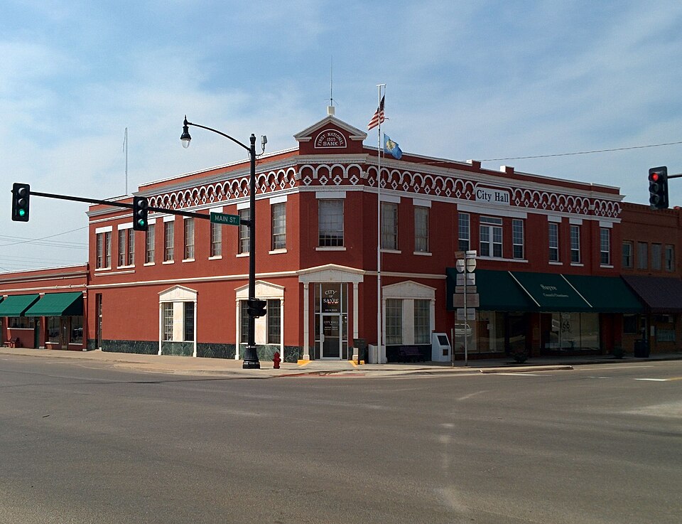
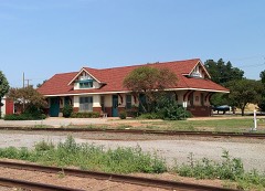
Photograph of Sayre Downtown Historic District
Photograph by Crimsonedge34, CC BY-SA 3.0. Via Wikimedia Commons.

Sayre Downtown Historic District

Listed on the National Register of Historic Places in 2002.

From the record

“The Sayre Downtown Historic District is a commercial historic district located in downtown Sayre, in the U.S. state of Oklahoma. The district comprises a three-block area of Main and 4th Streets; it includes 39 buildings, of which 24 are contributing buildings.”

Wikipedia article Sayre Downtown Historic District, CC BY-SA 4.0.

One of 13 National Register listings published here for Beckham County · listed in 2002 · category: District.

Sources: the Wikipedia article · the case file at the National Archives · the National Register database, National Park Service

The listing

  • What is counted as historic. The nomination lists 24 buildingss as contributing to the listing.
  • Address. Main and Fourth Sts., Sayre, 73662
  • When was it listed? December 2002
  • Category. district
  • Census division. Sayre
  • National Register reference number. 02000972 - the number the National Park Service assigned this property when it was listed, and the key its nomination file is catalogued under at the National Archives.

Storms near this property

60 of 102 shown

Regional context, not property-specific evidence. The National Weather Service names Sayre, the town this property stands in, in 102 storm reports between 1993 and 2025: 61 hail, 27 thunderstorm wind, 5 tornado, 3 lightning. The reports record 1 injury. Each account below is quoted exactly as the forecast office filed it, from the NOAA Storm Events Database, and each date opens the federal record of that event.

WhenEvent Place namedHarm What the report says
May 1998Thunderstorm WindSayre1 hurt, $36,000no account filed
May 2009Thunderstorm WindSayre$3,500,000Signs were blown onto Interstate 40 near exit 26. The west bound lanes had to be closed briefly as a result. Monetary damages were estimated.
May 1998Thunderstorm WindSayre$50,000no account filed
May 1993Tornado (F0)Sayre$50,000no account filed
June 1996Thunderstorm WindSayre$30,000no account filed
August 1999LightningSayre$20,000Lightning struck a tank battery used for oil and gas storage. The battery was destroyed by fire.
May 1999Thunderstorm WindSayre$20,000no account filed
May 1998Thunderstorm WindSayre$15,500no account filed
May 1997Thunderstorm WindSayre$15,000Severe thunderstorm winds blew part of the roof off of the Sayre elementary school library. Winds also uprooted large trees and downed at least one utility pole in town. Reports of more minor tree and roof damage were widepsread across Sayre.
June 1997LightningSayre$4,000Lightning struck and set fire to a house, gutting the kitchen.
May 2019Flash FloodSayre$2,000Multiple semi trucks and cars stranded in high flood waters over interstate 40. Time of first flooding estimated based on radar.
July 2014Thunderstorm WindSayre$2,000Metal roof blown off mobile home at highway 283 and country road east 1240.
October 2001Tornado (F0)Sayre$2,000A3. Numerous trees were damaged by this tornado.
June 1997LightningSayre$2,000Lightning struck a house, destroying several appliances and blowing holes in the sheetrock and eaves.
July 2014Thunderstorm WindSayre$1,000Several large trees uprooted along highway 283 and country road east 1230. Damages estimated.
May 2020Thunderstorm WindSayre$500An irrigation system was flipped over by an apparent gustnado.
October 2001Tornado (F0)Sayre$500A1. This tornado caused minor damage to trees.
March 2000Thunderstorm WindSayre$500Two carports and a fence were damaged.
June 1997Thunderstorm WindSayre$500Severe thunderstorm winds blew down a large Texaco sign at the Sayre exit off I-40.
October 2001Tornado (F0)Sayre$100A4. A few trees were damaged by this tornado.
June 2025HailSayre-The location is approximate.
June 2025Thunderstorm WindSayre-An estimated wind gust from a broadcast media storm chaser. The location is approximate.
July 2025Thunderstorm WindSayre-A measured wind gust near the junction of Interstate 40 and U.S. Highway 283.
May 2024HailSayre-MPing report.
June 2023HailSayre-MPing report.
June 2023Thunderstorm WindSayre-Semi-trailer flipped along Interstate 40. Time is radar estimated.
July 2023Thunderstorm WindSayre-Social media image showing a 1224-inch diameter tree snapped halfway up. Time is radar estimated.
May 2020HailSayre-Approximated location.
May 2020HailSayre-Time and location estimate from radar.
April 2020HailSayre-Golf ball sized hail at mile marker 18 on I-40.
May 2019Flash FloodSayre-Twitter report with picture. Timber Bean Creek and Coffee Bean Creek both out of their banks at Doxey ok, east of Sayre. Over 3 inches of rainfall in a little over an hour.
May 2019FloodSayre-High school football field was covered with standing water.
August 2016FloodSayre-Water ran over the roadway on highway 283.
April 2015Thunderstorm WindSayre-No damage reported.
May 2013Thunderstorm WindSayre-Fire Department estimated gusts to 60 mph.
August 2009Thunderstorm WindSayre-Shingles were blown off of a hotel, located of exit 20 on Interstate 40. Monetary damages were estimated.
September 2008HailSayre-The hail was reported on Highway 283.
September 2008Heavy RainSayre-The measured rainfall was 3.98 inches, much of it falling in a six to eight hour period.
September 2003Flash FloodSayre-Sayre City Park was flooded.
October 2001Tornado (F0)Sayre-A2. This tornado formed in an open field with no known damage.
June 2023HailSayre-no account filed
March 2021HailSayre-no account filed
May 2020HailSayre-no account filed
April 2020HailSayre-no account filed
May 2018HailSayre-no account filed
October 2017HailSayre-no account filed
May 2017HailSayre-no account filed
April 2012HailSayre-no account filed
November 2011HailSayre-no account filed
May 2011HailSayre-no account filed
May 2010HailSayre-no account filed
April 2009HailSayre-no account filed

Every storm recorded in Beckham County

Map coverage status

No historic map-sheet match is published for this property yet. That does not mean no map exists. This record needs a coordinate-quality review before it can be joined to a sheet boundary. Browse the county's mapped places while that work is pending.

Listed places nearby

5 within 8 miles

Other National Register properties close enough to walk or drive between, ordered by distance from this one. Both positions come from the same geocoding pass that matched these properties to their map sheets.

Photograph PropertyDistance Listed
Sayre Champlin Service Stationunder 500 feet2004
Sayre Rock Island Depot0.1 miles2000
Beckham County Courthouse0.2 miles1984
J.W. Danner House0.2 miles2002
Sayre City Park1.2 miles2004

Sources for this property

National Archives recordThe nomination case file for reference 02000972 in Record Group 79.
Wikipedia articleCommunity-written account of this property, licensed CC BY-SA.
Beckham CountyAll 13 listed properties in this county.

Provenance

  • Listing record. National Park Service National Register of Historic Places, listed-properties dataset, current to 2026-05-22.
  • Map join. Address geocoded through the United States Census geocoder, then tested against the published boundary of every sheet in the USGS Historical Topographic Map Collection.
  • How this page is made. Listing fields come from federal records; map-sheet coverage is a labelled coordinate-to-boundary calculation, not a source-field claim.
  • Storms. NOAA National Centers for Environmental Information, Storm Events Database https://www.ncei.noaa.gov/stormevents/ A work of the United States government, no copyright under 17 U.S.C. 105. Narratives are quoted verbatim from the National Weather Service report and are not edited or summarised.