 Block
From the record
One of 107 National Register listings published here for Tulsa County · listed in 2003 · category: Building.
Sources: the case file at the National Archives · the National Register database, National Park Service
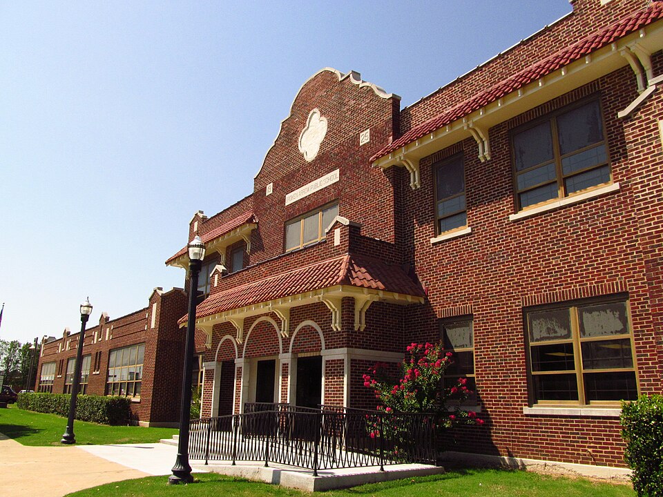
Listed on the National Register of Historic Places in 2003.
One of 107 National Register listings published here for Tulsa County · listed in 2003 · category: Building.
Sources: the case file at the National Archives · the National Register database, National Park Service
Regional context, not property-specific evidence. The federal wildfire occurrence database lists 2 fires within 5 miles of Broken Arrow Elementary-Junior High School between 2009 and 2012, burning about 54 acres in total. None started naturally. None was recorded as arson. Distance is straight-line from the map coordinates, so a fire counted here may appear on a neighbouring settlement's page as well.
| Reported cause | Fires |
|---|---|
| Missing data/not specified/undetermined | 1 |
| Debris and open burning | 1 |
The most recent of them, most recent first, with the day each was reported and the service that recorded it.
| Date | Cause | Size | Reported by | Name on the report |
|---|---|---|---|---|
| 4 March 2012 | Missing data/not specified/undetermined | 48 acres | Okmulgee Field Office | BRUNER |
| 16 March 2009 | Debris and open burning | 6.0 acres | Oklahoma Division of Forestry | 30480 |
Regional context, not property-specific evidence. The federal mineral resources record lists 2 workings within 5 miles of Broken Arrow Elementary-Junior High School: 1 past producer, 1 producer. 1 still produces. What was taken out: Sand and Gravel, Construction. Distance is straight-line from the map coordinates, so a quarry counted here may appear on a neighbouring settlement's page as well.
| Where | Site | Commodity | Status | Recorded |
|---|---|---|---|---|
| Tri Angle Pit #1 | Sand and Gravel, Construction | Producer | ||
| Unknown Sand and Gravel Pit | Sand and Gravel, Construction | Past Producer |
Regional context, not property-specific evidence. The National Weather Service names Broken Arrow, the town this property stands in, in 219 storm reports between 1994 and 2025: 111 hail, 82 thunderstorm wind, 16 flash flood, 6 tornado. The reports record 1 death and 1 injury. Each account below is quoted exactly as the forecast office filed it, from the NOAA Storm Events Database, and each date opens the federal record of that event.
| When | Event | Place named | Harm | What the report says |
|---|---|---|---|---|
| July 2005 | Lightning | Broken Arrow | 1 killed, 1 hurt | Two teenagers were struck by lightning when it struck a tree under which they were playing. Both teenagers went into cardiac arrest as a result of the strike but were revived and taken to the hospital. One of the teenagers later died (on October 11, 2005) from injuries and complications of those injuries. The other teenager was released after a prolonged period of hospitalization but must undergo extensive speech, physical, and occupational health therapy as a result of the lightning strike. |
| May 2024 | Hail | Broken Arrow | $250,000 | Hail slightly larger than baseball size damaged vehicles, homes, and businesses. |
| May 2024 | Hail | Broken Arrow | $250,000 | Tennis ball size hail damaged homes, businesses, and vehicles. |
| May 2024 | Hail | Broken Arrow | $150,000 | Hail slightly larger than golf ball size damaged homes and vehicles. |
| May 2024 | Hail | Broken Arrow | $100,000 | Hail up to the size of hen eggs damaged homes and vehicles. |
| May 2024 | Hail | Broken Arrow | $100,000 | Golf ball size hail damaged homes and vehicles. |
| May 2019 | Tornado (EF0) | Broken Arrow | $100,000 | This is the first segment of a two-segment tornado. This tornado developed near Lynn Lane, north of the Broken Arrow Expressway. It moved east across several neighborhoods, where the roofs of homes were damaged and large tree limbs were snapped. It moved across the southern portion of the Broken Arrow High School facilities, where the baseball field was damaged. Based on this damage, maximum estimated wind in this segment of the tornado was 75 to 80 mph. The tornado continued into Wagoner County. |
| March 1999 | Tornado (F1) | Broken Arrow | $100,000 | A tornado touched down in Broken Arrow in the Turtle Creek subdivision just southwest of 81st Street (Houston Street) and 145th East Avenue (Aspen Avenue). The tornado then moved across Aspen Avenue into the Wedgewood subdivision, crossed 81st Street, nipping the southeast corner of the Aspen Creek subdivision. The tornado finally lifted near Park Grove Cemetery, which is on the north side of 81st Street about halfway between 145th and 161st East Avenue. Sixty homes received at least some minor F0-strength roof damage, but two homes in the Turtle Creek subdivision lost parts of their roofs, causing this tornado to be rated an F1 on the Fujita scale. Three buildings at an apartment complex just east of Aspen lost parts of their roofs, and a window was blown out. This tornado blew over numerous trees and privacy fences. An off-duty NWS employee located about three blocks south of where the tornado lifted reported wind gusts to 60 miles an hour lasting for less than one minute. At 606 PM, an aircraft pilot reported a funnel cloud near Broken Arrow. |
| May 2008 | Tornado (EF0) | Broken Arrow | $75,000 | A tornado destroyed a storage building on the west side of Rhema Bible College, damaged the roofs of a business and several homes, and blew down trees and power lines. |
| May 2025 | Hail | Broken Arrow | $50,000 | Golf ball size hail damaged homes and vehicles. |
| May 2024 | Hail | Broken Arrow | $50,000 | Golf ball size hail damaged homes and vehicles. |
| May 2013 | Tornado (EF1) | Broken Arrow | $50,000 | This is the first of two segments for this tornado. This tornado developed south of E 96th Street South and west of S 16th Street where it damaged roofs of homes, snapped or uprooted large trees, and destroyed barns as it moved northeast. Based on this damage, maximum estimated wind in this segment of the tornado was 100 to 110 mph. The tornado continued into Wagoner County, crossing County Line Road near E 94th Street South. |
| July 2013 | Lightning | Broken Arrow | $50,000 | A home was struck by lightning, resulting in a fire that damaged it. |
| December 1999 | Hail | Broken Arrow | $50,000 | Golf ball size hail was reported at the corner of 81st street and Oak avenue. |
| May 1999 | Lightning | Broken Arrow | $50,000 | Lightning struck a two-story house in the 800 block of East Mason Drive in Broken Arrow, sparking a fire that destroyed the entire second floor of the home. |
| May 2024 | Hail | Broken Arrow | $40,000 | Half dollar size hail damaged homes and vehicles. |
| May 2024 | Hail | Broken Arrow | $40,000 | Half dollar size hail damaged homes and vehicles. |
| June 2023 | Hail | Broken Arrow | $40,000 | Golf ball size hail damaged homes, businesses, and vehicles. |
| May 2024 | Hail | Broken Arrow | $30,000 | Half dollar size hail damaged homes and vehicles. |
| June 2023 | Thunderstorm Wind | Broken Arrow | $30,000 | Strong thunderstorm wind destroyed the press box at the Broken Arrow Freshman Academy football field. |
| July 2022 | Tornado (EF1) | Broken Arrow | $30,000 | This is the first segment of a two segment tornado. This tornado developed just east of Lynn Lane and south of E Kenosha Street, where a few trees were uprooted and large tree limbs were snapped. The roofs of homes were damaged and an outbuilding was destroyed in the path, before the tornado moved into Wagoner County near the intersection of County Line Road and E Kenosha Street. Based on this damage, estimated wind in this segment of the tornado was 90 to 95 mph. |
| August 2006 | Flash Flood | Broken Arrow | $30,000 | Heavy thunderstorm rains flooded roads and some houses near 111th Street South and Mingo. One vehicle stalled in high water in the same area. |
| June 2023 | Hail | Broken Arrow | $25,000 | Ping pong ball size hail damaged homes, businesses, and vehicles. |
| June 2023 | Thunderstorm Wind | Broken Arrow | $25,000 | Strong thunderstorm wind removed a portion of the roof of a building, and uprooted trees. |
| July 2016 | Thunderstorm Wind | Broken Arrow | $25,000 | Strong thunderstorm wind snapped numerous large tree limbs, blew shingles off the roofs of homes, and damaged privacy fencing. |
| April 2017 | Hail | Broken Arrow | $25,000 | no account filed |
| October 2023 | Thunderstorm Wind | Broken Arrow | $20,000 | Strong thunderstorm wind snapped a large tree limb onto a house. |
| April 2011 | Hail | Broken Arrow | $20,000 | no account filed |
| April 2011 | Hail | Broken Arrow | $20,000 | no account filed |
| November 1999 | Thunderstorm Wind | Broken Arrow | $15,000 | Several large tree branches were blown out of trees near 81st Street South (Houston) and 161st East Avenue (Elm Place). The Broken Arrow Police Department measured a 60 mph wind gust which blew the roof off of a building in downtown Broken Arrow. A spotter at 91st and 193rd East Avenue near the Tulsa/Wagoner County line reported a wind gust to 75 miles an hour. |
| June 2025 | Thunderstorm Wind | Broken Arrow | $10,000 | Strong thunderstorm wind snapped large tree limbs, one of which fell onto a vehicle. |
| June 2023 | Thunderstorm Wind | Broken Arrow | $10,000 | Strong thunderstorm wind snapped numerous large tree limbs, and blew down power lines. |
| June 2023 | Thunderstorm Wind | Broken Arrow | $10,000 | Strong thunderstorm wind blew down power poles and power lines near E 91st Street and County Line Road. |
| December 2008 | Thunderstorm Wind | Broken Arrow | $10,000 | Thunderstorm winds estimated at 80 miles an hour blew the roof off a building. |
| June 2023 | Thunderstorm Wind | Broken Arrow | $5,000 | Strong thunderstorm wind damaged a car wash, and snapped large tree limbs. |
| April 2006 | Thunderstorm Wind | Broken Arrow | $5,000 | Thunderstorm winds estimated at 70 miles an hour damaged a roof of a business, blew down large tree limbs and caused power outages. |
| April 2004 | Thunderstorm Wind | Broken Arrow | $5,000 | A trained spotter reported 60 mile an hour winds and downed power lines near the intersection of 81st Street and 129th East Avenue. |
| May 2019 | Thunderstorm Wind | Broken Arrow | $2,000 | Strong thunderstorm wind blew shingles from the roof of a home and snapped large tree limbs. |
| December 2019 | Tornado (EF0) | Broken Arrow | $2,000 | This is the first segment of a two-segment tornado. This tornado developed over an open area west of County Line Road and south of E 101st Street S. It moved northeast and crossed the Wagoner County Line, where it pushed over power poles. Based on this damage, maximum estimated wind in this segment of the tornado was 80 to 85 mph. |
| July 2018 | Thunderstorm Wind | Broken Arrow | $2,000 | Strong thunderstorm wind damaged the roof of a home and blew down large tree limbs. |
| August 2017 | Thunderstorm Wind | Broken Arrow | $2,000 | Strong thunderstorm wind snapped large tree limbs and blew shingles off the roofs of homes. |
| June 1998 | Thunderstorm Wind | Broken Arrow | $2,000 | Power lines down near 71st and 145th E Ave |
| July 1997 | Thunderstorm Wind | Broken Arrow | $2,000 | no account filed |
| July 2021 | Thunderstorm Wind | Broken Arrow | $1,000 | Strong thunderstorm wind snapped large tree limbs, and blew shingles off of a roof. |
| July 2018 | Thunderstorm Wind | Broken Arrow | $1,000 | Strong thunderstorm wind blew down a section of privacy fence. |
| May 2009 | Thunderstorm Wind | Broken Arrow | $1,000 | Thunderstorm winds estimated at 70 miles an hour blew down a large tree and a privacy fence near the intersection of 81st Street South of 145th East Avenue. |
| June 2008 | Thunderstorm Wind | Broken Arrow | $1,000 | Thunderstorm winds estimated at 60 miles an hour snapped a power pole off near the intersection of 61st Street South and Lynn Lane. |
| June 2007 | Thunderstorm Wind | Broken Arrow | $1,000 | Thunderstorms winds estimated at 60 miles an hour blew down large tree limbs and power lines near the intersection of 61st Street South and Lynn Lane. |
| August 2005 | Thunderstorm Wind | Broken Arrow | $1,000 | Thunderstorm winds estimated at 60 miles an hour blew down power lines between Olive and Aspen on 91st Street South. In addition, large tree limbs were blown down near the intersection of Lynn Lane and 71st Street South. |
| July 2000 | Thunderstorm Wind | Broken Arrow | $1,000 | Thunderstorm winds blew down several large tree limbs and power lines. |
| February 2008 | Thunderstorm Wind | Broken Arrow | $500 | Thunderstorm winds estimated at 60 miles an hour blew some shingles off a roof of a home. |
| March 2008 | Thunderstorm Wind | Broken Arrow | $500 | Thunderstorm winds estimated at 60 miles an hour ripped shingles from the roof of a home. |
| May 1999 | Thunderstorm Wind | Broken Arrow | $500 | Several trees were blown down in Broken Arrow near the intersection of 91st and 129th East Avenue. |
| July 1994 | Thunderstorm Wind | Broken Arrow | $500 | no account filed |
| May 1999 | Thunderstorm Wind | Broken Arrow | $100 | Several large tree limbs were blown down in Wedgewood Park (near 81st and 145th East Avenue) by winds estimated at 60 miles an hour. Throughout Tulsa County, between 15,000 and 20,000 electric customers lost power when the storm caused tree limbs to fall onto power lines, lightning to hit transformers and wind gusts to blow down power lines. |
| May 2025 | Thunderstorm Wind | Broken Arrow | - | Strong thunderstorm wind snapped numerous large tree limbs. |
| June 2025 | Thunderstorm Wind | Broken Arrow | - | Thunderstorm wind gusts measured to 62 mph snapped large tree limbs. |
| September 2025 | Thunderstorm Wind | Broken Arrow | - | Strong thunderstorm wind snapped large tree limbs. |
| June 2025 | Flash Flood | Broken Arrow | - | Portions of Lynn Lane were flooded between E 101st Street and E 111th Street. |
| June 2025 | Flash Flood | Broken Arrow | - | The intersection of E 91st Street and County Line Road was closed due to flooding. |
No historic map-sheet match is published for this property yet. That does not mean no map exists. This record needs a coordinate-quality review before it can be joined to a sheet boundary. Browse the county's mapped places while that work is pending.
Other National Register properties close enough to walk or drive between, ordered by distance from this one. Both positions come from the same geocoding pass that matched these properties to their map sheets.
| Photograph | Property | Distance | Listed |
|---|---|---|---|
| Haskell State School of Agriculture | 0.6 miles | 1978 | |
| Holland Hall Upper School | 7.0 miles | 2021 |
| National Archives record | The nomination case file for reference 03000095 in Record Group 79. |
| Tulsa County | All 107 listed properties in this county. |