 Block
From the record
One of 19 National Register listings published here for Rogers County · listed in 2003 · category: Building.
Sources: the case file at the National Archives · the National Register database, National Park Service
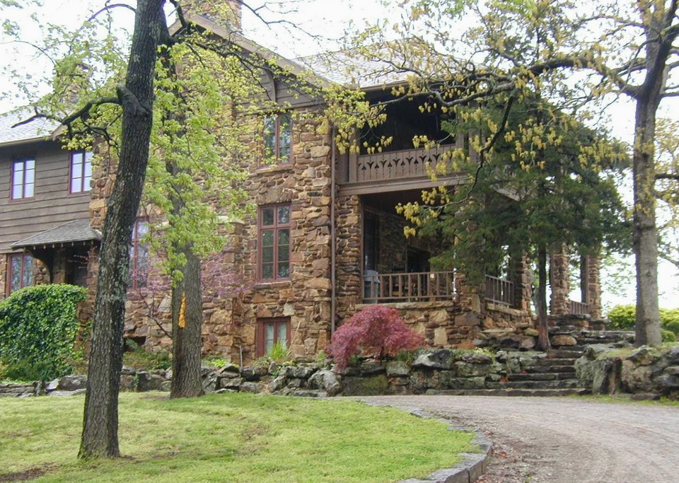
Listed on the National Register of Historic Places in 2003.
One of 19 National Register listings published here for Rogers County · listed in 2003 · category: Building.
Sources: the case file at the National Archives · the National Register database, National Park Service
Regional context, not property-specific evidence. The federal mineral resources record lists 7 workings within 5 miles of Verdigris Club Lodge: 6 past producers, 1 producer. 1 still produces. What was taken out: Sand and Gravel, Construction, Stone, Crushed/Broken. Distance is straight-line from the map coordinates, so a quarry counted here may appear on a neighbouring settlement's page as well.
| Where | Site | Commodity | Status | Recorded |
|---|---|---|---|---|
| Unknown Limestone Pit | Stone, Crushed/Broken | Past Producer | ||
| Unknown Limestone Pit | Stone, Crushed/Broken | Past Producer | ||
| Taylor Sand & Gravel Dredge | Sand and Gravel, Construction | Producer | ||
| Unknown Gravel Pit | Sand and Gravel, Construction | Past Producer | ||
| Unknown Gravel Pit | Sand and Gravel, Construction | Past Producer | ||
| Unknown Gravel Pit | Sand and Gravel, Construction | Past Producer | ||
| Unknown Gravel Pit | Sand and Gravel, Construction | Past Producer |
Regional context, not property-specific evidence. The National Weather Service names Catoosa, the town this property stands in, in 108 storm reports between 1993 and 2025: 50 hail, 42 thunderstorm wind, 10 flash flood, 6 tornado. No death or injury is recorded in these reports. Each account below is quoted exactly as the forecast office filed it, from the NOAA Storm Events Database, and each date opens the federal record of that event.
| When | Event | Place named | Harm | What the report says |
|---|---|---|---|---|
| March 2016 | Tornado (EF1) | Catoosa | $750,000 | This is the third segment of a three segment tornado. In Rogers County, the tornado moved east-northeast passing across the northern portion of the Patriot Golf Club and Stone Canyon housing subdivisions. Numerous homes were damaged in this area, some severely. Several homes under construction were destroyed. The tornado crossed Highway 266 destroying a business, damaging a number of homes, destroying barns and outbuildings, and snapping or uprooting numerous trees until it dissipated north of Verdigris. Based on this damage, maximum estimated wind in this segment of the tornado was 110 to 120 mph. |
| May 2010 | Tornado (EF2) | Catoosa | $750,000 | A tornado developed near the Port of Catoosa where it damaged a metal building structure and blew down trees and power poles. The tornado moved northeast across portions of Verdigris, severely damaging several homes, destroying barns, snapping or uprooting numerous trees, and blowing down power poles. The estimated peak wind in the tornado based on this damage was 120 mph. |
| June 2023 | Thunderstorm Wind | Catoosa | $657,000 | Thunderstorm wind, likely gusting to at least 100 mph at times, resulted in at least $657,000 in debris removal and damage to the utility infrastructure across the county during this severe thunderstorm. Some people were without power for over a week. |
| March 2020 | Hail | Catoosa | $100,000 | Large hail damaged the roofs of homes. |
| March 2020 | Hail | Catoosa | $100,000 | Large hail damaged the roofs of homes. |
| March 2020 | Hail | Catoosa | $100,000 | Large hail damaged the roofs of homes. |
| August 2001 | Thunderstorm Wind | Catoosa | $100,000 | Thunderstorms winds estimated at 80 miles an hour severely damaged a few warehouses and blew over four empty train cars. |
| June 2023 | Thunderstorm Wind | Catoosa | $50,000 | Strong thunderstorm wind damaged a building on Port Road north of Catoosa. |
| May 2015 | Flash Flood | Catoosa | $50,000 | Flood waters damaged homes in Rolling Hills subdivision, south of Catoosa, at E 3rd Street and S 197th E Avenue. |
| August 2023 | Thunderstorm Wind | Catoosa | $30,000 | Strong thunderstorm wind damaged a hangar at Gundys Airport, and blew down trees and power lines in the area. |
| June 2004 | Thunderstorm Wind | Catoosa | $25,000 | Thunderstorm winds estimated at 70 miles an hour destroyed a metal building at Frontier Terminal at the Port of Catoosa. |
| March 2015 | Hail | Catoosa | $25,000 | no account filed |
| May 2011 | Hail | Catoosa | $25,000 | no account filed |
| August 2019 | Thunderstorm Wind | Catoosa | $20,000 | Strong thunderstorm wind damaged football equipment at the Catoosa High School. |
| March 2015 | Hail | Catoosa | $20,000 | no account filed |
| June 2023 | Flash Flood | Catoosa | $15,000 | Portions of several roads were flooded and closed. A few vehicles were stranded in flood water. |
| June 2011 | Thunderstorm Wind | Catoosa | $15,000 | Strong thunderstorm wind blew down or snapped several large trees and destroyed a barn. |
| May 2011 | Hail | Catoosa | $15,000 | no account filed |
| March 2015 | Thunderstorm Wind | Catoosa | $10,000 | Strong thunderstorm wind blew some windows out of homes. |
| August 2011 | Thunderstorm Wind | Catoosa | $10,000 | The Hard Rock Casino sustained wind damage to the facade of the building. |
| May 2010 | Tornado (EF0) | Catoosa | $10,000 | A tornado damaged a barn and blew down trees and power poles. The estimated peak wind in the tornado based on this damage was 80 mph. |
| October 2023 | Thunderstorm Wind | Catoosa | $5,000 | Strong thunderstorm wind blew down multiple trees and snapped power poles on E 76th St N, on east side of Owasso. |
| May 2019 | Hail | Catoosa | $5,000 | no account filed |
| March 2016 | Hail | Catoosa | $5,000 | no account filed |
| August 1997 | Thunderstorm Wind | Catoosa | $5,000 | no account filed |
| November 1999 | Thunderstorm Wind | Catoosa | $3,000 | Thunderstorm winds blew down trees and power poles from Catoosa to Verdigris. |
| October 2023 | Thunderstorm Wind | Catoosa | $2,000 | Strong thunderstorm wind snapped large tree limbs, and blew down power lines. |
| March 2015 | Thunderstorm Wind | Catoosa | $2,000 | Strong thunderstorm wind damaged a few signs. |
| June 1998 | Thunderstorm Wind | Catoosa | $500 | Several trees were blown down. |
| April 1993 | Hail | Catoosa | $500 | no account filed |
| June 1996 | Thunderstorm Wind | Catoosa | $100 | no account filed |
| July 1996 | Thunderstorm Wind | Catoosa | $100 | no account filed |
| April 1993 | Tornado (F3) | Catoosa | $30 | no account filed |
| May 2025 | Thunderstorm Wind | Catoosa | - | Strong thunderstorm wind snapped large tree limbs. |
| May 2024 | Flash Flood | Catoosa | - | Portions of E 76th St N, and other nearby roads, were flooded near the county line. |
| May 2024 | Flash Flood | Catoosa | - | Portions of E 161st East Avenue were flooded between E 76th Street N and E 86th Street N. |
| June 2023 | Thunderstorm Wind | Catoosa | - | Strong thunderstorm wind snapped numerous large tree limbs. |
| June 2023 | Thunderstorm Wind | Catoosa | - | Strong thunderstorm wind blew down a tree onto Redbud Drive in Catoosa. |
| June 2023 | Thunderstorm Wind | Catoosa | - | Thunderstorm wind gusts were estimated to 100 mph. |
| July 2023 | Thunderstorm Wind | Catoosa | - | Strong thunderstorm wind snapped large tree limbs. |
| August 2023 | Thunderstorm Wind | Catoosa | - | Thunderstorm wind gusts were estimated to be in excess of 80 mph. |
| November 2021 | Tornado (EF0) | Catoosa | - | This tornado snapped large tree limbs. Based on this damage, maximum estimated wind in the tornado was 75 to 80 mph. |
| May 2019 | Tornado (EFU) | Catoosa | - | This is the second segment of a two-segment tornado. This tornado was reported by a trained storm spotter. It developed south of Highway 412 in northern Wagoner County and moved east-northeast into southern Rogers County. There is no known damage from the tornado. |
| June 2019 | Thunderstorm Wind | Catoosa | - | Strong thunderstorm wind snapped large tree limbs in a neighborhood near E 81st Street N and N 161st E Avenue. |
| May 2018 | Thunderstorm Wind | Catoosa | - | Strong thunderstorm wind blew down a large tree. |
| August 2018 | Thunderstorm Wind | Catoosa | - | Strong thunderstorm wind snapped large tree limbs. |
| May 2017 | Thunderstorm Wind | Catoosa | - | Strong thunderstorm wind blew down several trees. |
| April 2017 | Thunderstorm Wind | Catoosa | - | Strong thunderstorm wind snapped large tree limbs. |
| July 2016 | Thunderstorm Wind | Catoosa | - | Strong thunderstorm wind snapped trees. |
| March 2015 | Thunderstorm Wind | Catoosa | - | A storm spotter estimated thunderstorm inflow winds of 80 mph. |
| May 2015 | Flash Flood | Catoosa | - | Numerous roads were flooded in and around town. |
| May 2015 | Flash Flood | Catoosa | - | The Rolling Hills subdivision, south of Catoosa, at E 3rd Street and S 197th E Avenue was flooded. |
| May 2015 | Flash Flood | Catoosa | - | Severe flooding occurred in and around Catoosa. Emergency services personnel rescued people from stalled vehicles on S 193rd E Avenue between E Admiral Place and E 11th Street. |
| May 2013 | Thunderstorm Wind | Catoosa | - | Strong thunderstorm wind blew down a large tree branch onto a driveway. |
| July 2013 | Thunderstorm Wind | Catoosa | - | Strong thunderstorm wind snapped numerous large tree limbs in the Cornerstone West subdivision. |
| June 2010 | Thunderstorm Wind | Catoosa | - | The media reported strong winds with thunderstorms just northwest of the Port of Catoosa. Numerous large tree limbs were blown down across a highway. |
| August 2010 | Thunderstorm Wind | Catoosa | - | Strong thunderstorm wind blew down numerous large tree limbs along a two mile stretch near East 580 Road between 241st and 289th East Avenue. |
| April 2008 | Hail | Catoosa | - | Penny size hail fell 3 miles east of Owasso. |
| June 2005 | Thunderstorm Wind | Catoosa | - | Thunderstorm winds estimated at 60 miles an hour blew down a large tree limb. It blocked a road. |
| November 2003 | Hail | Catoosa | - | Numerous pieces of hail up to penny size covered the ground just south of Catoosa. The hail was several inches deep in places. |
No historic map-sheet match is published for this property yet. That does not mean no map exists. This record needs a coordinate-quality review before it can be joined to a sheet boundary. Browse the county's mapped places while that work is pending.
Other National Register properties close enough to walk or drive between, ordered by distance from this one. Both positions come from the same geocoding pass that matched these properties to their map sheets.
| Photograph | Property | Distance | Listed |
|---|---|---|---|
 | Belvidere, The | 6.9 miles | 1982 |
| Will Rogers Memorial Library | 6.9 miles | 2023 | |
| Downtown Claremore Historic District | 7.0 miles | 2016 | |
 | Claremore Auto Dealership | 7.0 miles | 1995 |
 | Will Rogers Hotel | 7.0 miles | 1994 |
| Mendenhall's Bath House | 7.0 miles | 1983 |
| National Archives record | The nomination case file for reference 03000876 in Record Group 79. |
| Rogers County | All 19 listed properties in this county. |