 Block
From the record
One of 32 National Register listings published here for Creek County · listed in 2004 · category: District.
Sources: the case file at the National Archives · the National Register database, National Park Service

Listed on the National Register of Historic Places in 2004.
One of 32 National Register listings published here for Creek County · listed in 2004 · category: District.
Sources: the case file at the National Archives · the National Register database, National Park Service
Regional context, not property-specific evidence. The federal wildfire occurrence database lists 4 fires within 5 miles of West Sapulpa Route 66 Roadbed between 2006 and 2012, burning about 1,730 acres in total. None started naturally. 2 were recorded as arson. Distance is straight-line from the map coordinates, so a fire counted here may appear on a neighbouring settlement's page as well.
| Reported cause | Fires |
|---|---|
| Arson/incendiarism | 2 |
| Missing data/not specified/undetermined | 1 |
| Debris and open burning | 1 |
The most recent of them, most recent first, with the day each was reported and the service that recorded it.
| Date | Cause | Size | Reported by | Name on the report |
|---|---|---|---|---|
| 4 August 2012 | Missing data/not specified/undetermined | 205 acres | Okmulgee Field Office | SHIFTY |
| 24 November 2006 | Arson/incendiarism | 21 acres | Okmulgee Field Office | TWO DOZER |
| 17 November 2007 | Debris and open burning | 3.5 acres | Okmulgee Field Office | GRAND CANYON |
| 1 January 2006 | Arson/incendiarism | 1,500 acres | Okmulgee Field Office | KELLYVILLE 3 |
Regional context, not property-specific evidence. The federal mineral resources record lists 7 workings within 5 miles of West Sapulpa Route 66 Roadbed: 4 past producers, 3 producers. 3 still produce. What was taken out: Clay, Stone, Crushed/Broken, Sand and Gravel, Construction. Distance is straight-line from the map coordinates, so a quarry counted here may appear on a neighbouring settlement's page as well.
| Where | Site | Commodity | Status | Recorded |
|---|---|---|---|---|
| Unknown Sand Pit | Sand and Gravel, Construction | Past Producer | ||
| Unknown Sandstone Pit | Stone, Crushed/Broken | Past Producer | ||
| Unknown Sandstone Pit | Stone, Crushed/Broken | Past Producer | ||
| Sapulpa Clay Pit | Clay | Producer | ||
| Sugar Loaf Hill Pit | Clay | Producer | ||
| Unknown Shale Pit | Clay | Producer | ||
| Unknown Shale Pit | Clay | Past Producer |
Regional context, not property-specific evidence. The National Weather Service names Sapulpa, the town this property stands in, in 142 storm reports between 1993 and 2026: 74 hail, 35 thunderstorm wind, 12 tornado, 11 flash flood. The reports record 1 death and 1 injury. Each account below is quoted exactly as the forecast office filed it, from the NOAA Storm Events Database, and each date opens the federal record of that event.
| When | Event | Place named | Harm | What the report says |
|---|---|---|---|---|
| May 2015 | Flood | Sapulpa | 1 killed | Several homes were evacuated by boat near Park and Washington Streets. A man drown in flood water near the intersection of S Hickory Road and W 186th Street S. |
| April 1995 | Thunderstorm Wind | Sapulpa | 1 hurt, $500,000 | no account filed |
| May 1999 | Tornado (F1) | Sapulpa | $6,500,000 | The same system that earlier caused a destructive tornado in Stroud and a less destructive tornado in southwest Creek County produced an F1 tornado which first touched down in the north side of Sapulpa near OK Hwy 97 and Interstate 44. The tornado then skipped through an industrial area before moving across I-44. From there, the tornado travelled northeast parallel to and just south of the New Sapulpa Road (OK Hwy 66), taking out a string of homes and businesses before eventually reaching Tulsa County. This tornado tracked a total of 7 miles, 5.5 miles of which was in Creek County. The Hilton Mobile Home Park was especially hard-hit, where about 15 mobile homes were damaged or destroyed. Twenty-four residents of the mobile home park were treated on the scene for minor injuries, but none required a hospital visit. Needless to say, this tornado also blew down numerous power lines and trees. All in all, along its path in Creek County, this tornado heavily damaged 12 homes and caused light to moderate damage to about 150 others. Twenty mobile homes were heavily damaged, and 25 businesses were damaged. Total property damage in Creek County is estimated at $5.5 million. For more information on this tornado, see the Tulsa County Tornado entry for information on the last 1.5 miles of its track. |
| May 2019 | Tornado (EF1) | Sapulpa | $800,000 | This is the first segment of a two-segment tornado. This large tornado developed near the Sapulpa Golf Course and moved east across Sapulpa, roughly between E Taft Avenue and E Dewey Avenue. It crossed Hickory Hill Road and S 49th West Avenue south of the Creek Turnpike, and moved into Tulsa County near W 111th Street S. The tornado damaged the roofs of many homes, damaged businesses, snapped numerous power poles, and snapped or uprooted numerous trees. Based on this damage, maximum estimated wind in this segment of the tornado was 100 to 110 mph. |
| May 2010 | Tornado (EF1) | Sapulpa | $250,000 | A tornado developed on the west side of Sapulpa and moved northeast across the north side of town. The tornado damaged a large metal building structure, severely damaged the roofs of numerous homes, snapped or uprooted numerous trees, and blew down power poles. The estimated peak wind in the tornado based on this damage was 110 mph. This tornado continued into Tulsa County, where it produced EF2 damage. |
| May 2024 | Hail | Sapulpa | $100,000 | Hail up to the size of golf balls damaged homes and vehicles. |
| May 2008 | Thunderstorm Wind | Sapulpa | $100,000 | Thunderstorm winds estimated at 80 miles an hour blew the roofs off of buildings at Westside Shopping Center. |
| June 2004 | Thunderstorm Wind | Sapulpa | $100,000 | Thunderstorm winds estimated at 70 miles an hour blew down trees. One tree smashed a carport when it fell. The wind also leveled the frame of an addition to church that was under construction. |
| November 1999 | Lightning | Sapulpa | $100,000 | Lightning struck an oil storage tank causing an explosion and a resulting fire. Four tanks were burned, two of which were filled with oil. |
| May 2024 | Hail | Sapulpa | $75,000 | Hail up to golf ball size damaged homes and vehicles. |
| July 2013 | Thunderstorm Wind | Sapulpa | $75,000 | Strong thunderstorm wind snapped large tree limbs. Many power lines and poles were blown down resulting in widespread power outages. |
| June 2008 | Hail | Sapulpa | $75,000 | no account filed |
| May 2024 | Hail | Sapulpa | $50,000 | Hail up to hen egg size damaged homes and vehicles. |
| June 2023 | Thunderstorm Wind | Sapulpa | $50,000 | Strong thunderstorm wind blew down trees and power poles, and damaged homes. |
| July 2016 | Thunderstorm Wind | Sapulpa | $50,000 | Strong thunderstorm wind blew much of the roof off of a home. |
| October 2004 | Flash Flood | Sapulpa | $50,000 | Heavy thunderstorm rains caused severe street flooding in Sapulpa. Two streets had to be blocked off and several vehicles stalled due to the high water. In addition to the street flooding water also entered a few buildings including a nursing home. |
| July 1994 | Thunderstorm Wind | Sapulpa | $50,000 | no account filed |
| May 2024 | Hail | Sapulpa | $40,000 | Up to hen egg size hail damaged homes and vehicles. |
| May 1999 | Tornado (F0) | Sapulpa | $40,000 | An F0 tornado moved through Sapulpa's central business district on Dewey Street, causing mostly cosmetic damage in the form of broken storefront windows and glass on the sidewalk. |
| May 2017 | Flash Flood | Sapulpa | $30,000 | Severe flooding was reported in Sapulpa. Several inches of flood water inundated a home. |
| October 2025 | Hail | Sapulpa | $25,000 | Half dollar size hail damaged homes and vehicles on the southeast side of Sapulpa. |
| May 2024 | Hail | Sapulpa | $25,000 | Golf ball size hail damaged homes and vehicles. |
| August 2018 | Flash Flood | Sapulpa | $25,000 | Several roads were reported flooded. High water flooded a business and threatened a home. |
| July 2016 | Thunderstorm Wind | Sapulpa | $25,000 | Strong thunderstorm wind blew down trees, one of which fell onto a home. |
| April 2011 | Hail | Sapulpa | $25,000 | no account filed |
| May 2024 | Hail | Sapulpa | $20,000 | Ping pong ball size hail damaged homes and vehicles. |
| March 2015 | Hail | Sapulpa | $20,000 | no account filed |
| May 2013 | Hail | Sapulpa | $20,000 | no account filed |
| June 2023 | Thunderstorm Wind | Sapulpa | $10,000 | Strong thunderstorm wind snapped numerous large tree limbs, and blew down power lines. |
| March 2015 | Hail | Sapulpa | $10,000 | no account filed |
| April 2011 | Hail | Sapulpa | $10,000 | no account filed |
| March 2006 | Hail | Sapulpa | $10,000 | no account filed |
| March 2017 | Thunderstorm Wind | Sapulpa | $5,000 | Strong thunderstorm wind damaged the roof of a home. |
| May 2004 | Tornado (F0) | Sapulpa | $5,000 | The storm which produced other tornadoes across Creek County earlier produced a brief tornado to the southwest of Sapulpa. This tornado destroyed a barn. |
| June 2019 | Hail | Sapulpa | $5,000 | no account filed |
| March 1996 | Thunderstorm Wind | Sapulpa | $5,000 | no account filed |
| August 2011 | Thunderstorm Wind | Sapulpa | $3,000 | A mobile home was damaged by strong thunderstorm wind near Highway 97. |
| July 2007 | Flash Flood | Sapulpa | $2,000 | Heavy rain caused street flooding near 65th West Avenue and Sapulpa Road. Two cars stalled in the high water. |
| October 1999 | Tornado (F0) | Sapulpa | $2,000 | A tornado briefly touched down 3 miles east of Sapulpa west of the intersection of OK Hwy 117 and US Hwy 75. A shed was destroyed, and windows were blown out of a mobile home. |
| September 1998 | Thunderstorm Wind | Sapulpa | $1,500 | Trees and power lines were blown down near Sapulpa. |
| May 2008 | Thunderstorm Wind | Sapulpa | $1,000 | Thunderstorm winds estimated at 70 miles an hour blew trees and power lines down. |
| April 2003 | Thunderstorm Wind | Sapulpa | $1,000 | Thunderstorm winds estimated at 70 miles an hour blew down trees and power lines. |
| June 1999 | Thunderstorm Wind | Sapulpa | $200 | A tree and several large tree limbs were blown over in Sapulpa. |
| May 1999 | Thunderstorm Wind | Sapulpa | $100 | Several 6-inch diameter tree limbs were blown down. |
| July 1996 | Thunderstorm Wind | Sapulpa | $100 | no account filed |
| May 2025 | Thunderstorm Wind | Sapulpa | - | Strong thunderstorm wind snapped numerous large tree limbs in and around Sapulpa. |
| October 2025 | Thunderstorm Wind | Sapulpa | - | Thunderstorm wind gusts were measured to 60 mph. |
| June 2023 | Thunderstorm Wind | Sapulpa | - | Strong thunderstorm wind blew down a large tree. |
| May 2022 | Flood | Sapulpa | - | Polecat Creek near Sapulpa rose above its flood stage of 21 feet at 5:00 am CDT on May 5th. The river crested at 26.50 feet at 1:30 pm CDT on the 5th, resulting in moderate flooding. Moderate flooding of pasture lands occurred between Sapulpa and Jenks. Several rural roads and outbuildings were flooded. Monetary damage from this flood was unknown. The river fell below flood stage at 7:00 pm CDT on the 6th. |
| July 2020 | Thunderstorm Wind | Sapulpa | - | Thunderstorm wind gusts were estimated to 70 mph. |
| May 2019 | Tornado (EF1) | Sapulpa | - | This tornado developed south of Sahoma Lake and moved north across the lake, then to the northeast, dissipating before reaching W 81st St S. The path is primarily based on radar data, which detected a strong gate-to-gate circulation and debris signature. A storm survey team from NWS Tulsa investigated the area for damage but couldn't access by road the area where the tornado occurred. The area is heavily wooded, which is most likely the origin of the radar detected tornadic debris signature. This tornado was observed by several people. |
| May 2019 | Flood | Sapulpa | - | A portion of S Hickory Street was flooded and closed near Rock Creek. |
| May 2019 | Flood | Sapulpa | - | Polecat Creek near Sapulpa rose above its flood stage of 21 feet at 4:00 am CDT on May 21st. The river crested at 28.00 feet at 4:00 pm CDT on the 21st, resulting in moderate flooding. Severe agricultural flooding occurred, and oil fields and county roads were flooded between Sapulpa and Jenks. Monetary damage from this flood is unknown. The river fell below flood stage at 10:30 am CDT on the 22nd. |
| May 2018 | Thunderstorm Wind | Sapulpa | - | Strong thunderstorm wind snapped large tree limbs. |
| May 2017 | Thunderstorm Wind | Sapulpa | - | Strong thunderstorm wind snapped large tree limbs. |
| April 2017 | Flash Flood | Sapulpa | - | Portions of S Hickory Street between W Taft Avenue and W Teel Road were closed due to flooding. |
| April 2016 | Thunderstorm Wind | Sapulpa | - | Strong thunderstorm wind snapped numerous large tree limbs. |
| June 2015 | Flash Flood | Sapulpa | - | Portions of Taft Road near Alternate Highway 75 were flooded and closed. |
| March 2012 | Flood | Sapulpa | - | The Polecat Creek near Sapulpa rose above its flood stage of 21 feet at 4:00 am CDT on March 20th. The river crested at 25.62 feet at 10:15 CDT on the 20th, resulting in moderate flooding. The river fell below flood stage at 1:15 am CDT on the 21st. |
| April 2011 | Thunderstorm Wind | Sapulpa | - | Strong thunderstorm wind blew down trees onto power lines. |
No historic map-sheet match is published for this property yet. That does not mean no map exists. This record needs a coordinate-quality review before it can be joined to a sheet boundary. Browse the county's mapped places while that work is pending.
Other National Register properties close enough to walk or drive between, ordered by distance from this one. Both positions come from the same geocoding pass that matched these properties to their map sheets.
| Photograph | Property | Distance | Listed |
|---|---|---|---|
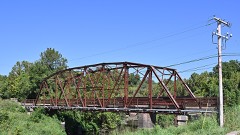 | Bridge No. 18 at Rock Creek | 1.4 miles | 1995 |
 | McClung House | 2.6 miles | 1980 |
 | Berryhill Building | 2.7 miles | 1999 |
| Sapulpa Downtown Historic District | 2.7 miles | 2002 | |
 | Creek County Courthouse | 2.8 miles | 1985 |
 | John Frank House | 3.3 miles | 2002 |
| National Archives record | The nomination case file for reference 04000128 in Record Group 79. |
| Creek County | All 32 listed properties in this county. |