 Block
From the record
One of 4 National Register listings published here for Harmon County · listed in 2007 · category: Building.
Sources: the case file at the National Archives · the National Register database, National Park Service
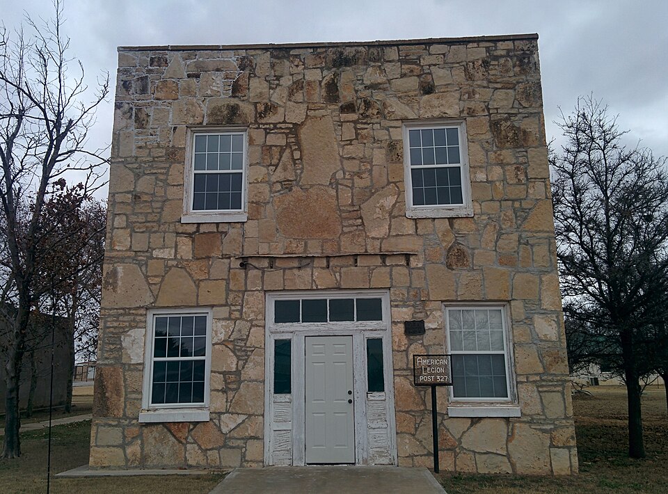
Listed on the National Register of Historic Places in 2007.
One of 4 National Register listings published here for Harmon County · listed in 2007 · category: Building.
Sources: the case file at the National Archives · the National Register database, National Park Service
Regional context, not property-specific evidence. The National Weather Service names Gould, the town this property stands in, in 107 storm reports between 1993 and 2026: 73 thunderstorm wind, 28 hail, 6 tornado. No death or injury is recorded in these reports. Each account below is quoted exactly as the forecast office filed it, from the NOAA Storm Events Database, and each date opens the federal record of that event.
| When | Event | Place named | Harm | What the report says |
|---|---|---|---|---|
| July 2015 | Thunderstorm Wind | Gould | $45,000 | Several sheds/carports lost their roofs. A camper shell and a boat were picked up and flipped. Several roofs were on the ground, porches were missing, trees were down, dumpsters were tipped over, and antennae were snapped. |
| April 2003 | Tornado (F1) | Gould | $30,000 | This is the final segment of the tornado that began in Hardeman County, Texas then moved northeast into extreme western Jackson County, Oklahoma before dissipating in Harmon County. The tornado caused F1 damage during this portion of the path. A farm located 10 miles south of Gould and 1 mile west of Highway 5 had five outbuildings destroyed and damaged the roof to a brick home. The tornado continued northeast and downed power lines along Highway 5 then dissipated approximately 1 mile east of Highway 5 at 1834 CST. |
| November 2024 | Tornado (EF1) | Gould | $15,000 | This tornado began south of Gould, along or just west of State Highway 5 and north of E1660 Road. The tornado moved to the north and then northwest, before dissipating just to the west of the city of Gould. Numerous power poles were snapped and broken along E1650 road, while several central pivot irrigation units sustained damage. |
| November 2024 | Tornado (EF1) | Gould | $5,000 | This tornado moved into southern Harmon County from far western Jackson County. Utility poles were snapped along and just north of the county line along State Highway 5. |
| April 2019 | Thunderstorm Wind | Gould | $5,000 | Power poles downed and outbuilding damage. Time estimated by radar. |
| June 1995 | Thunderstorm Wind | Gould | $5,000 | no account filed |
| May 1996 | Thunderstorm Wind | Gould | $200 | no account filed |
| July 2004 | Thunderstorm Wind | Gould | $100 | Elm tree limbs 9 to 10 inches in diameter were snapped off. |
| June 1997 | Thunderstorm Wind | Gould | $10 | Two-inch diameter tree limbs were blown from trees. |
| April 2026 | Thunderstorm Wind | Gould | - | Hollis (HOLL) Mesonet observation. |
| May 2024 | Thunderstorm Wind | Gould | - | Hollis (HOLL) Mesonet observation. |
| May 2024 | Tornado (EF0) | Gould | - | A few storm chasers observed a weak tornado southwest of Gould. This is believed to be a landspout tornado that developed under new updraft bases well south of the primary storm updraft. No damage is known to have occurred. |
| May 2024 | Hail | Gould | - | Hail size increased from ping pong ball to golf ball between 1718-1720 LST. |
| August 2023 | Thunderstorm Wind | Gould | - | Hollis (HOLL) Mesonet observation. |
| May 2022 | Thunderstorm Wind | Gould | - | Quality controlled by Mesonet staff, believed to be good data. |
| May 2019 | Tornado (EFU) | Gould | - | Multiple storm chasers observed a brief tornado estimated to be about 2 miles north-northeast of Gould. No damage was reported. |
| June 2019 | Thunderstorm Wind | Gould | - | Hollis mesonet site. |
| May 2018 | Thunderstorm Wind | Gould | - | Series of measured wind gusts of 58 to 81 mph between 7PM and 7:25PM (measured at 5 minute intervals). |
| July 2015 | Thunderstorm Wind | Gould | - | Around 8 stockade fence panels were blown down. Minor tree damage was also reported. |
| May 2015 | Thunderstorm Wind | Gould | - | No damage reported. |
| May 2015 | Thunderstorm Wind | Gould | - | Several trees blown down. |
| May 2013 | Thunderstorm Wind | Gould | - | Mesonet station at Hollis reported a gust to 69 mph. |
| May 2013 | Hail | Gould | - | Relayed by local media (Kswo). |
| April 2013 | Hail | Gould | - | No damage was reported. |
| June 2006 | Thunderstorm Wind | Gould | - | Wind gust was measured by the Oklahoma mesonet. |
| June 2006 | Thunderstorm Wind | Gould | - | Wind gust was measured by the Oklahoma mesonet. |
| May 2006 | Thunderstorm Wind | Gould | - | Wind gust was measured by the Oklahoma mesonet. |
| May 2006 | Thunderstorm Wind | Gould | - | Wind gust was measured by the Oklahoma mesonet. |
| May 2006 | Thunderstorm Wind | Gould | - | Wind gust was measured by the Oklahoma mesonet. |
| May 2005 | Hail | Gould | - | Pea to penny size hail was reported covering the ground. |
| June 2004 | Thunderstorm Wind | Gould | - | Wind was measured by the Oklahoma mesonet. |
| April 2003 | Thunderstorm Wind | Gould | - | Wind was measured by the Oklahoma mesonet. |
| April 2002 | Thunderstorm Wind | Gould | - | Wind was measured by the Oklahoma mesonet. |
| June 2002 | Thunderstorm Wind | Gould | - | Wind was measured by the Oklahoma mesonet. |
| June 2002 | Thunderstorm Wind | Gould | - | Wind was measured by the Oklahoma mesonet. |
| May 2001 | Thunderstorm Wind | Gould | - | Wind was measured by Oklahoma mesonet. |
| May 2001 | Thunderstorm Wind | Gould | - | Wind was measured by Oklahoma mesonet. |
| May 2001 | Thunderstorm Wind | Gould | - | Wind was measured by Oklahoma Mesonet. |
| May 2000 | Thunderstorm Wind | Gould | - | Measured by the Oklahoma mesonet. |
| July 1997 | Thunderstorm Wind | Gould | - | measured at the Oklahoma Mesonet site. |
| June 1997 | Thunderstorm Wind | Gould | - | measured at the Oklahoma Mesonet site |
| March 1997 | Thunderstorm Wind | Gould | - | measured at the Oklahoma Mesonet site |
| February 2023 | Thunderstorm Wind | Gould | - | no account filed |
| May 2022 | Thunderstorm Wind | Gould | - | no account filed |
| May 2022 | Thunderstorm Wind | Gould | - | no account filed |
| June 2022 | Thunderstorm Wind | Gould | - | no account filed |
| June 2022 | Thunderstorm Wind | Gould | - | no account filed |
| June 2022 | Thunderstorm Wind | Gould | - | no account filed |
| August 2021 | Thunderstorm Wind | Gould | - | no account filed |
| August 2021 | Thunderstorm Wind | Gould | - | no account filed |
| August 2021 | Thunderstorm Wind | Gould | - | no account filed |
| August 2020 | Thunderstorm Wind | Gould | - | no account filed |
| August 2020 | Thunderstorm Wind | Gould | - | no account filed |
| April 2020 | Thunderstorm Wind | Gould | - | no account filed |
| May 2019 | Thunderstorm Wind | Gould | - | no account filed |
| June 2019 | Thunderstorm Wind | Gould | - | no account filed |
| April 2019 | Hail | Gould | - | no account filed |
| April 2019 | Hail | Gould | - | no account filed |
| April 2019 | Hail | Gould | - | no account filed |
| April 2019 | Hail | Gould | - | no account filed |
No historic map-sheet match is published for this property yet. That does not mean no map exists. This record needs a coordinate-quality review before it can be joined to a sheet boundary. Browse the county's mapped places while that work is pending.
| National Archives record | The nomination case file for reference 07001264 in Record Group 79. |
| Harmon County | All 4 listed properties in this county. |