 Block
From the record
One of 22 National Register listings published here for Le Flore County · listed in 2020 · category: Building.
Sources: the National Register database, National Park Service · the Wikipedia article
Listed on the National Register of Historic Places in 2020.
One of 22 National Register listings published here for Le Flore County · listed in 2020 · category: Building.
Sources: the National Register database, National Park Service · the Wikipedia article
Regional context, not property-specific evidence. The federal wildfire occurrence database lists 76 fires within 5 miles of Hotel Lowrey between 1992 and 2019, burning about 2,008 acres in total. 4 started naturally. 25 were recorded as arson. Distance is straight-line from the map coordinates, so a fire counted here may appear on a neighbouring settlement's page as well.
| Reported cause | Fires |
|---|---|
| Arson/incendiarism | 25 |
| Missing data/not specified/undetermined | 21 |
| Debris and open burning | 9 |
| Railroad operations and maintenance | 7 |
| Equipment and vehicle use | 5 |
| Natural | 4 |
| Misuse of fire by a minor | 2 |
| Recreation and ceremony | 2 |
| Smoking | 1 |
The most recent of them, most recent first, with the day each was reported and the service that recorded it.
| Date | Cause | Size | Reported by | Name on the report |
|---|---|---|---|---|
| 8 September 2009 | Recreation and ceremony | 1.0 acres | Oklahoma Division of Forestry | 20470 |
| 6 September 2010 | Arson/incendiarism | 125 acres | Oklahoma Division of Forestry | 20228 |
| 30 September 1994 | Missing data/not specified/undetermined | 640 acres | Oklahoma Division of Forestry | not named |
| 26 September 2017 | Arson/incendiarism | 301 acres | Oklahoma Division of Forestry | not named |
| 24 September 2004 | Debris and open burning | under an acre | Oklahoma Division of Forestry | 20369 |
| 2 September 2002 | Equipment and vehicle use | under an acre | Oklahoma Division of Forestry | not named |
| 5 August 2011 | Equipment and vehicle use | 10 acres | Oklahoma Division of Forestry | 20397 |
| 20 August 2013 | Arson/incendiarism | under an acre | Oklahoma Division of Forestry | not named |
Regional context, not property-specific evidence. The federal mineral resources record lists 1 working within 5 miles of Hotel Lowrey: 1 past producer. None of them still produces. What was taken out: Stone, Crushed/Broken. Distance is straight-line from the map coordinates, so a quarry counted here may appear on a neighbouring settlement's page as well.
| Where | Site | Commodity | Status | Recorded |
|---|---|---|---|---|
| Unknown Sandstone Pit | Stone, Crushed/Broken | Past Producer |
Regional context, not property-specific evidence. The National Weather Service names Poteau, the town this property stands in, in 125 storm reports between 1993 and 2026: 57 thunderstorm wind, 49 hail, 15 flash flood, 4 flood. No death or injury is recorded in these reports. Each account below is quoted exactly as the forecast office filed it, from the NOAA Storm Events Database, and each date opens the federal record of that event.
| When | Event | Place named | Harm | What the report says |
|---|---|---|---|---|
| January 1999 | Hail | Poteau | $2,600,000 | Golfball-sized hail caused major damage in Poteau. Many cars had their windshields broken out, their mirrors and antennae knocked off, and some cars were dented so badly that it knocked off paint. The entire police fleet suffered dents. Roof damage on many buildings was considerable. State Farm Insurance alone had 800 building damage claims and 350 auto claims stemming from the storm. The awning on the Black Angus restaurant on Broadway was shredded by the force of the hail. State Farm reported $1.6 million in claims, and the Reed-Williams Insurance Company reported $1 million in claims two weeks after the storm, and more claims were still coming in. All in all, this was a historic hailstorm for Poteau. |
| April 2026 | Hail | Poteau | $100,000 | Tennis ball size hail damaged homes and vehicles. |
| May 2005 | Thunderstorm Wind | Poteau | $50,000 | Thunderstorm winds measured at 58 miles an hour blew over a camper trailer, destroyed a mobile home, and damaged the roof of a business. |
| May 2001 | Flash Flood | Poteau | $50,000 | Heavy thunderstorm rains flooded several homes and businesses. |
| May 2015 | Thunderstorm Wind | Poteau | $40,000 | Strong thunderstorm wind blew down trees onto several homes. |
| February 2023 | Hail | Poteau | $25,000 | Golf ball size hail damaged homes and vehicles. |
| April 2016 | Thunderstorm Wind | Poteau | $25,000 | Strong thunderstorm wind damaged buildings in town. |
| August 2006 | Thunderstorm Wind | Poteau | $25,000 | Thunderstorm winds estimated at 80 miles an hour damaged a few roofs of buildings. |
| April 2017 | Hail | Poteau | $25,000 | no account filed |
| March 2019 | Hail | Poteau | $20,000 | no account filed |
| March 2019 | Hail | Poteau | $20,000 | no account filed |
| March 2019 | Hail | Poteau | $20,000 | no account filed |
| April 2015 | Hail | Poteau | $20,000 | no account filed |
| May 2019 | Thunderstorm Wind | Poteau | $15,000 | Strong thunderstorm wind uprooted a tree, which fell onto a vehicle. |
| April 2014 | Thunderstorm Wind | Poteau | $15,000 | Strong thunderstorm wind blew down two trees onto cars and snapped numerous large tree limbs. |
| June 2012 | Thunderstorm Wind | Poteau | $15,000 | Strong thunderstorm wind blew down a tree and snapped large tree limbs. Power poles and lines were also blown down near Choctaw Golf Course off of Highway 59. |
| March 2019 | Hail | Poteau | $15,000 | no account filed |
| July 2018 | Thunderstorm Wind | Poteau | $10,000 | Strong thunderstorm wind blew down a communications tower onto the roof of a hospital, snapped large tree limbs and power poles, and blew the siding off a home. |
| May 2013 | Thunderstorm Wind | Poteau | $10,000 | A building had portions of its roof blown off and several other buildings had windows blown out by strong thunderstorm wind. Numerous trees and power lines were blown down. |
| May 2011 | Thunderstorm Wind | Poteau | $10,000 | Strong thunderstorm wind blew down trees and power lines across the county. |
| August 2006 | Thunderstorm Wind | Poteau | $10,000 | Thunderstorm winds estimated at 70 miles an hour blew down large tree limbs and damaged a few roofs of homes. |
| June 1998 | Thunderstorm Wind | Poteau | $10,000 | A large tree was blown onto a residence on Mockingbird Lane. One of the larger branches tore through a bedroom wall, narrowly missing the bed. Termites or ants had apparently been inside the tree for some time and the large tree was rotted from the inside. |
| May 1998 | Thunderstorm Wind | Poteau | $10,000 | Several houses in Poteau were damaged, and several trees were blown down. |
| April 2011 | Hail | Poteau | $10,000 | no account filed |
| July 2022 | Thunderstorm Wind | Poteau | $5,000 | Strong thunderstorm wind snapped large tree limbs, and blew down power poles. |
| July 2020 | Thunderstorm Wind | Poteau | $5,000 | Strong thunderstorm wind blew down trees, and damaged the roof of a home. |
| September 2020 | Flash Flood | Poteau | $5,000 | Multiple swift water rescues were conducted in and around Poteau, as people became stranded in flood water. |
| November 2018 | Thunderstorm Wind | Poteau | $5,000 | Strong thunderstorm wind peeled off portions of the roof of a mobile home. |
| March 2017 | Thunderstorm Wind | Poteau | $5,000 | Strong thunderstorm wind damaged several roofs of homes and tore the awning from a home. |
| July 2014 | Thunderstorm Wind | Poteau | $5,000 | Strong thunderstorm wind damaged the roof of a business. |
| August 2013 | Thunderstorm Wind | Poteau | $5,000 | Strong thunderstorm wind blew down the sign outside a business. |
| September 2012 | Thunderstorm Wind | Poteau | $5,000 | Strong thunderstorm wind blew down numerous trees and power lines. |
| August 2006 | Thunderstorm Wind | Poteau | $5,000 | Thunderstorm winds estimated at 60 miles an hour blew the roof off a barn. |
| April 1995 | Thunderstorm Wind | Poteau | $5,000 | no account filed |
| June 1999 | Thunderstorm Wind | Poteau | $4,000 | At least 15 large trees were uprooted along old Hwy 59 between Poteau and Howe. One tree fell onto a storage shed, and a home lost numerous shingles. |
| June 2004 | Thunderstorm Wind | Poteau | $3,000 | Thunderstorm winds estimated near 80 miles an hour blew down a very large tree and peeled a section of siding off a house. |
| May 2001 | Thunderstorm Wind | Poteau | $3,000 | Thunderstorm winds blew down power lines. |
| August 2014 | Thunderstorm Wind | Poteau | $2,000 | Strong thunderstorm wind blew down a couple trees and snapped numerous large tree limbs. A swing set and play house were also blown over. |
| October 1998 | Thunderstorm Wind | Poteau | $1,500 | A carport and part of a fence were damaged on Conser Street. |
| July 2002 | Thunderstorm Wind | Poteau | $1,000 | Thunderstorm winds estimated at 70 miles an hour blew down trees and power lines. The wind also blew out the front window of a business. |
| October 2001 | Thunderstorm Wind | Poteau | $1,000 | Thunderstorms winds estimated at 60 miles an hour blew a few signs down. |
| November 1998 | Thunderstorm Wind | Poteau | $1,000 | Trees and limbs were blown down in Poteau and throughout LeFlore County. |
| July 1995 | Thunderstorm Wind | Poteau | $500 | Severe thunderstorms moved across eastern Oklahoma during the early morning of July 24th. Thunderstorm winds damaged boat docks and a mobile home one mile east of Texanna. Numerous large trees were also blown down blocking roads in the same area. A hand-held anemometer reached its peak speed of 65 mph one mile east of Texanna. Strong thunderstorm winds caused severe roof damage to one building in Webbers Falls, and several trees were blown onto roofs in Webbers Falls. Six cars were damaged at the intersection of 48th Street and Wheeling Avenue in the city of Tulsa when a large tree was blown down, and a barn roof was partially blown off one mile east of Hectorville. Strong thunderstorm winds blew canopies off mobile homes in Poteau, and trees were blown down and roofs were damaged by strong winds in Ashland. Several trees and power lines were blown down in Burbank and in Drumright, and trees were blown down four miles north of Hulbert and in Sallisaw. Numerous large tree limbs were blown down in Indianola, and a large part of a tree was blown down in Broken Arrow. Thunderstorm winds gusted to 60 to 70 mph in Hallett and to 60 mph five miles west of Okemah, and dime-size hail fell one mile north of Muskogee. |
| May 1998 | Thunderstorm Wind | Poteau | $100 | Large trees blown down |
| March 1998 | Thunderstorm Wind | Poteau | $100 | 3-inch tree limb downed by wind |
| May 2024 | Thunderstorm Wind | Poteau | - | Strong thunderstorm wind snapped large tree limbs. |
| January 2020 | Flash Flood | Poteau | - | Portions of several roads were flooded in and around town. |
| October 2019 | Thunderstorm Wind | Poteau | - | Strong thunderstorm wind blew down numerous trees on the east side of town. |
| March 2017 | Thunderstorm Wind | Poteau | - | Strong thunderstorm wind snapped large tree limbs. |
| April 2015 | Flash Flood | Poteau | - | Several roads were flooded in and around town. |
| May 2015 | Thunderstorm Wind | Poteau | - | Thunderstorm wind gusts were measured to 78 mph. |
| April 2015 | Flash Flood | Poteau | - | Several streets were flooded and impassable in and around town. |
| June 2014 | Thunderstorm Wind | Poteau | - | Strong thunderstorm wind blew down several trees. |
| October 2014 | Thunderstorm Wind | Poteau | - | Strong thunderstorm wind blew down numerous large tree limbs. |
| October 2014 | Thunderstorm Wind | Poteau | - | Strong thunderstorm wind blew down numerous large tree limbs. |
| July 2013 | Thunderstorm Wind | Poteau | - | Strong thunderstorm wind blew down a large tree. |
| April 2012 | Thunderstorm Wind | Poteau | - | Strong thunderstorm wind blew down several trees. |
| July 2012 | Thunderstorm Wind | Poteau | - | Strong thunderstorm wind blew down small trees. |
| August 2012 | Flash Flood | Poteau | - | Several roads were closed in Poteau due to heavy rainfall. |
| August 2012 | Thunderstorm Wind | Poteau | - | Thunderstorm wind gusts of 75 mph were measured at the EOC in Poteau. |
No historic map-sheet match is published for this property yet. That does not mean no map exists. This record needs a coordinate-quality review before it can be joined to a sheet boundary. Browse the county's mapped places while that work is pending.
Other National Register properties close enough to walk or drive between, ordered by distance from this one. Both positions come from the same geocoding pass that matched these properties to their map sheets.
| Photograph | Property | Distance | Listed |
|---|---|---|---|
 | Poteau Community Building | 0.2 miles | 1988 |
 | LeFlore County Courthouse | 0.2 miles | 1984 |
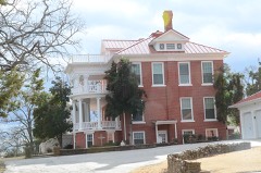 | Terry House | 0.4 miles | 1980 |
 | Twyman Park | 1.1 miles | 1988 |
| Shady Point School | 6.0 miles | 1988 | |
 | James E. Reynolds House | 7.7 miles | 1977 |
| National Archives record | The nomination case file for reference 100005860 in Record Group 79. |
| Wikipedia article | Community-written account of this property, licensed CC BY-SA. |
| Le Flore County | All 22 listed properties in this county. |