 Block
From the record
One of 12 National Register listings published here for Grady County · listed in 2011 · category: District.
Sources: the case file at the National Archives · the National Register database, National Park Service
Listed on the National Register of Historic Places in 2011.
One of 12 National Register listings published here for Grady County · listed in 2011 · category: District.
Sources: the case file at the National Archives · the National Register database, National Park Service
Regional context, not property-specific evidence. The federal wildfire occurrence database lists 2 fires within 5 miles of Knippelmeir Farmstead between 2016 and 2019, burning about 25 acres in total. None started naturally. None was recorded as arson. Distance is straight-line from the map coordinates, so a fire counted here may appear on a neighbouring settlement's page as well.
| Reported cause | Fires |
|---|---|
| Debris and open burning | 1 |
| Equipment and vehicle use | 1 |
The most recent of them, most recent first, with the day each was reported and the service that recorded it.
| Date | Cause | Size | Reported by | Name on the report |
|---|---|---|---|---|
| 18 August 2019 | Debris and open burning | 25 acres | Anadarko Agency | BUGGY CREEK |
| 17 August 2016 | Equipment and vehicle use | under an acre | Anadarko Agency | SIERRA |
Regional context, not property-specific evidence. The federal mineral resources record lists 3 workings within 5 miles of Knippelmeir Farmstead: 3 past producers. None of them still produces. What was taken out: Sand and Gravel, Construction. Distance is straight-line from the map coordinates, so a quarry counted here may appear on a neighbouring settlement's page as well.
| Where | Site | Commodity | Status | Recorded |
|---|---|---|---|---|
| Unknown Gravel Pit | Sand and Gravel, Construction | Past Producer | ||
| Unknown Gravel Pit | Sand and Gravel, Construction | Past Producer | ||
| Unknown Gravel Pit | Sand and Gravel, Construction | Past Producer |
Regional context, not property-specific evidence. The National Weather Service names Minco, the town this property stands in, in 117 storm reports between 1993 and 2026: 75 thunderstorm wind, 27 hail, 9 tornado, 6 flash flood. No death or injury is recorded in these reports. Each account below is quoted exactly as the forecast office filed it, from the NOAA Storm Events Database, and each date opens the federal record of that event.
| When | Event | Place named | Harm | What the report says |
|---|---|---|---|---|
| May 2007 | Tornado (EF1) | Minco | $70,000 | Damage was first observed to dairy facility 2.7 miles southwest of Minco where the western portion of the south wall was pushed in which in turn pushed the roof and the northern wall of the building to the north. To the northwest, a farm sustained roof damage to the house, and damage to three metal storage buildings and two barns. Fences and trees were also damaged along the path. Monetary damages were estimated. |
| August 2007 | Tornado (EF1) | Minco | $45,000 | A tornado touched down just southeast of the center of the town of Minco and moved through the eastern portion of the town. At least four mobile homes in Minco were damaged, with one losing a significant portion of the exterior walls and roof. Trees were also damaged along the path as the tornado moved north crossing the Canadian River into Canadian County. Monetary damages were estimated. |
| May 2015 | Flash Flood | Minco | $30,000 | Truck hydroplaned into ditch on Highway 37 between Robbins Rd and County Rd 2870. Water over roadway. |
| May 1999 | Tornado (F1) | Minco | $20,000 | Tornado B10. See summary at end of May 3rd storm reports. |
| May 1999 | Tornado (F1) | Minco | $15,000 | Tornado B11. See summary at end of May 3rd storm reports. |
| March 2026 | Hail | Minco | $10,000 | Hailfall near the intersection of Oklahoma State Highway 37/152 and County Street 2810 damaged several solar panels and vehicle windshields. The event time is estimated based on radar observations. |
| February 2023 | Tornado (EF0) | Minco | $10,000 | A barn and a garage were damaged along County Road 1200 to the west-southwest of Minco by a relatively brief tornado. |
| May 2013 | Thunderstorm Wind | Minco | $1,000 | One foot diameter tree was downed. |
| May 1999 | Tornado (F1) | Minco | $1,000 | Tornado B8. See summary at end of May 3rd storm reports. |
| June 2015 | Thunderstorm Wind | Minco | $500 | A barn was damaged by straight line winds. |
| May 2002 | Thunderstorm Wind | Minco | $10 | Two inch diameter tree limbs were downed. |
| March 2026 | Hail | Minco | - | The location is approximate. |
| March 2026 | Thunderstorm Wind | Minco | - | Minco (MINC) Mesonet observation. |
| November 2024 | Flash Flood | Minco | - | Roadway flooding, with an estimated water depth of 8 to 10 inches, occurred along a portion of U.S. Highway 81. Event time is approximate. |
| August 2024 | Thunderstorm Wind | Minco | - | Minco (MINC) Mesonet observation. |
| August 2024 | Thunderstorm Wind | Minco | - | Minco (MINC) Mesonet observation. |
| August 2024 | Thunderstorm Wind | Minco | - | Minco (MINC) Mesonet observation. |
| May 2024 | Thunderstorm Wind | Minco | - | Minco (MINC) Mesonet observation. |
| May 2024 | Thunderstorm Wind | Minco | - | Minco (MINC) Mesonet observation. |
| May 2024 | Thunderstorm Wind | Minco | - | Minco (MINC) Mesonet observation. |
| July 2023 | Thunderstorm Wind | Minco | - | Minco (MINC) Mesonet observation. |
| July 2023 | Thunderstorm Wind | Minco | - | Minco (MINC) Mesonet observation. |
| July 2023 | Thunderstorm Wind | Minco | - | Minco (MINC) Mesonet observation. |
| June 2021 | Tornado (EF0) | Minco | - | Videos of a landspout tornado were taken by both a local resident and a glider pilot who circled the vortex. The path of the tornado could be determined by geolocation from the videos, but the time is estimated. No structural damage was known to occur. |
| August 2019 | Hail | Minco | - | Twitter picture with a measurement. |
| May 2018 | Flash Flood | Minco | - | Local official reported water flowing over roadways west and southwest of Minco. Time estimated. |
| June 2015 | Thunderstorm Wind | Minco | - | No damage reported. |
| June 2015 | Thunderstorm Wind | Minco | - | No damage reported. |
| May 2015 | Hail | Minco | - | No damage was reported. |
| May 2015 | Flash Flood | Minco | - | Shoulder of road washed away at Southwest Sager Rd between Highways 81 and 37. Other secondary roads also flooded. |
| June 2013 | Thunderstorm Wind | Minco | - | Mesonet site at Minco recorded a gust to 64 mph at 3:00am LST. Also recorded 59 mph at 2:55am LST. |
| May 2013 | Tornado (EF0) | Minco | - | Brief tornado reported by KWTV and a Spotter Network storm chaser. |
| August 2012 | Thunderstorm Wind | Minco | - | No damage was reported. |
| September 2012 | Thunderstorm Wind | Minco | - | Mesonet site at Minco recorded a gust to 66 mph. |
| September 2012 | Thunderstorm Wind | Minco | - | Mesonet site at Minco measured a gust to 67 mph. Also measured gusts to 63 mph at 9:55pm CST, 67 mph at 10:00pm CST, and 59 mph at 10:15pm CST. |
| February 2009 | Hail | Minco | - | The hail covered the ground. |
| May 2007 | Flash Flood | Minco | - | Several streets closed due to high water. |
| June 2005 | Thunderstorm Wind | Minco | - | Wind was measured by the Oklahoma mesonet. |
| July 2005 | Thunderstorm Wind | Minco | - | Wind was measured by the Oklahoma mesonet. |
| July 2005 | Thunderstorm Wind | Minco | - | Wind was measured by the Oklahoma mesonet. |
| June 2005 | Thunderstorm Wind | Minco | - | Wind was measured by the Oklahoma mesonet. |
| August 2005 | Thunderstorm Wind | Minco | - | The wind was measured by the Oklahoma mesonet. |
| April 2004 | Hail | Minco | - | Hail covered the ground. |
| May 2003 | Tornado (F0) | Minco | - | This is the final segment of the tornado that began in Caddo County, 1.4 miles northeast of Cogar, and moved east-northeast crossing into Grady County before dissipating. The tornado crossed the county line a quarter mile north of EW115 Road on NS275 Road. No significant damage was noted in Grady County. However, wheat swirls were seen just to the northeast of the location where the tornado crossed into Grady County. |
| May 2002 | Thunderstorm Wind | Minco | - | Wind was measured by the Oklahoma mesonet. |
| May 2001 | Thunderstorm Wind | Minco | - | Wind was measured by Oklahoma mesonet. |
| May 2001 | Thunderstorm Wind | Minco | - | Wind was measured by Oklahoma mesonet. |
| August 2001 | Thunderstorm Wind | Minco | - | Wind was measured by Oklahoma mesonet. |
| July 2000 | Thunderstorm Wind | Minco | - | Wind was measured by the Oklahoma mesonet. |
| July 2000 | Thunderstorm Wind | Minco | - | Wind was measured by the Oklahoma mesonet. |
| July 2000 | Thunderstorm Wind | Minco | - | Wind was measured by the Oklahoma mesonet. |
| July 2000 | Thunderstorm Wind | Minco | - | Wind was measured by the Oklahoma mesonet. |
| July 2000 | Thunderstorm Wind | Minco | - | Wind was measured by the Oklahoma mesonet. |
| July 1998 | Thunderstorm Wind | Minco | - | Winds gusted to 58 mph at 1945 CST, measured by Oklahoma Mesonet. Winds gusted to 83 mph at 1950 CST, also measured by Oklahoma Mesonet. |
| June 2025 | Hail | Minco | - | no account filed |
| February 2023 | Thunderstorm Wind | Minco | - | no account filed |
| April 2022 | Hail | Minco | - | no account filed |
| April 2022 | Hail | Minco | - | no account filed |
| June 2022 | Flash Flood | Minco | - | no account filed |
| July 2021 | Thunderstorm Wind | Minco | - | no account filed |
No historic map-sheet match is published for this property yet. That does not mean no map exists. This record needs a coordinate-quality review before it can be joined to a sheet boundary. Browse the county's mapped places while that work is pending.
Other National Register properties close enough to walk or drive between, ordered by distance from this one. Both positions come from the same geocoding pass that matched these properties to their map sheets.
| Photograph | Property | Distance | Listed |
|---|---|---|---|
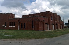 | Minco Armory | 3.1 miles | 1994 |
| National Archives record | The nomination case file for reference 11000638 in Record Group 79. |
| Grady County | All 12 listed properties in this county. |