 Block
From the record
One of 12 National Register listings published here for Washington County · listed in 2014 · category: Building.
Sources: the National Register database, National Park Service
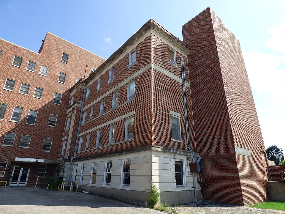
Listed on the National Register of Historic Places in 2014.
One of 12 National Register listings published here for Washington County · listed in 2014 · category: Building.
Sources: the National Register database, National Park Service
Regional context, not property-specific evidence. The federal wildfire occurrence database lists 32 fires within 5 miles of Washington County Memorial Hospital between 2000 and 2020, burning about 4,903 acres in total. 3 started naturally. 8 were recorded as arson. Distance is straight-line from the map coordinates, so a fire counted here may appear on a neighbouring settlement's page as well.
| Reported cause | Fires |
|---|---|
| Debris and open burning | 8 |
| Arson/incendiarism | 8 |
| Missing data/not specified/undetermined | 6 |
| Power generation/transmission/distribution | 4 |
| Natural | 3 |
| Recreation and ceremony | 1 |
| Equipment and vehicle use | 1 |
| Firearms and explosives use | 1 |
The most recent of them, most recent first, with the day each was reported and the service that recorded it.
| Date | Cause | Size | Reported by | Name on the report |
|---|---|---|---|---|
| 4 September 2012 | Natural | 1.1 acres | Osage Agency | HOPPER 1 |
| 19 September 2000 | Missing data/not specified/undetermined | 2,500 acres | Oklahoma Division of Forestry | OSAGE HILLS |
| 23 July 2009 | Arson/incendiarism | 13 acres | Osage Agency | BLACK JACK |
| 9 April 2019 | Debris and open burning | 545 acres | Osage Agency | RADAR HILL |
| 24 April 2006 | Debris and open burning | 35 acres | Cherokee Nation Tribe | LITTLE ROCK 2 |
| 19 April 2006 | Power generation/transmission/distribution | 45 acres | Osage Agency | HUDSON RD |
| 17 April 2006 | Debris and open burning | 43 acres | Osage Agency | LITTLE ROCK |
| 16 April 2008 | Arson/incendiarism | 6.7 acres | Osage Agency | LOTTA HELP |
Regional context, not property-specific evidence. The federal mineral resources record lists 18 workings within 5 miles of Washington County Memorial Hospital: 16 past producers, 1 plant, 1 producer. 2 still produce. What was taken out: Sand and Gravel, Construction, Clay, Stone, Crushed/Broken, Zinc. Distance is straight-line from the map coordinates, so a quarry counted here may appear on a neighbouring settlement's page as well.
| Where | Site | Commodity | Status | Recorded |
|---|---|---|---|---|
| (Facility) Bartlesville Smelter/Refinery | Zinc, Cadmium, Sulfur, Sulfuric Acid | Plant | ||
| B&C Quarry & Plant | Stone, Crushed/Broken | Producer | ||
| Unknown Limestone Pit | Stone, Crushed/Broken | Past Producer | ||
| Unknown Limestone Pit | Stone, Crushed/Broken | Past Producer | ||
| Unknown Limestone Pit | Stone, Crushed/Broken | Past Producer | ||
| Unknown Shale Pit | Clay | Past Producer | ||
| Unknown Shale Pit | Clay | Past Producer | ||
| Unknown Shale Pit | Clay | Past Producer | ||
| Unknown Shale Pit | Clay | Past Producer | ||
| Unknown Gravel Pit | Sand and Gravel, Construction | Past Producer |
Regional context, not property-specific evidence. The National Weather Service names Bartlesville, the town this property stands in, in 169 storm reports between 1993 and 2026: 84 hail, 60 thunderstorm wind, 16 flash flood, 7 flood. No death or injury is recorded in these reports. Each account below is quoted exactly as the forecast office filed it, from the NOAA Storm Events Database, and each date opens the federal record of that event.
| When | Event | Place named | Harm | What the report says |
|---|---|---|---|---|
| May 2024 | Tornado (EF2) | Bartlesville | $15,000,000 | This is the second segment of a two-segment tornado. The tornado crossed into Washington County near Gap Road, and moved across the southwestern portion of Bartlesville, and then across the central and northeastern side of town. An estimated 1000 homes and businesses were damaged in town, some severely. Numerous trees were snapped or uprooted, and many power poles were snapped. A squall line merged with the tornadic supercell, and ultimately ended the tornado process northeast of Bartlesville. Based on this damage, maximum estimated wind in this segment of the tornado was 115 to 125 mph. |
| May 2000 | Hail | Bartlesville | $2,000,000 | Golfball to softball size hail fell in Bartlesville damaging roofs, windows and cars. |
| September 2014 | Thunderstorm Wind | Bartlesville | $1,500,000 | Emergency management personnel measured thunderstorm wind gusts to 80 mph. A hospital, a school, and an apartment complex sustained major damage to their roofs due to the strong wind. Nearly 600 homes were also damaged by the wind, about 100 of which had major damage. Numerous trees and large tree limbs were blown down along with many power poles. Over 10,000 people were without power in Bartlesville at the height of the storm. School was canceled the following day due to the prolonged power outage in the area and due to storm debris covering many roads used by the school buses. |
| July 2007 | Flood | Bartlesville | $1,000,000 | The Caney River near Bartlesville rose above its flood stage of 13 feet at 4 am CDT on June 30. The river crested at 21.45 feet at 9:30 am CDT on July 2. The river fell below its flood stage at 5 pm CDT on July 6.||The flood category reached the major level. 2500-3000 residents were displaced across Washington County due to the flood. 85 residents were evacuated in Dewey. The total amount of homes receiving flood damage was roughly 250. Numerous streets were closed during the flood, including nearly every east-west street in Bartlesville. Damages totaled for government infrastructure were roughly $400,000. Total damages estimated at $1 million. |
| May 2001 | Hail | Bartlesville | $1,000,000 | no account filed |
| May 1993 | Thunderstorm Wind | Bartlesville | $500,000 | no account filed |
| May 2003 | Thunderstorm Wind | Bartlesville | $400,000 | Thunderstorm winds estimated at 80 miles an hour associated with a line of thundestorms referred to as a bow echo did serious damage to homes and businesses, especially in the Oak Park neighborhood. Light to moderate damage was reported for 129 homes. This included shingles and gutters blown off roofs and broken windows. Severe damage was done to two homes whose roofs were blown off making them uninhabitable. Of the businesses which were damaged two were considered to have light to moderate damage and one was reported to have severe damage. One building that received roof damage was the Lighthouse Outreach Center where a flat tar roof was pealed back by the wind. After the roof was damaged rainfall caused water damage. Total damage to the building was estimated at $100,000. In addition to the damage to buildings, trees and power lines were also knocked down resulting in power outages. |
| April 2026 | Hail | Bartlesville | $150,000 | Golf ball size hail damaged homes, businesses, and vehicles. |
| April 2026 | Hail | Bartlesville | $100,000 | Hail up to two inches in diameter damaged homes and vehicles. |
| August 2003 | Thunderstorm Wind | Bartlesville | $75,000 | Thunderstorm winds estimated at 80 miles an hour did considerable damage in the Bartlesville area.Numerous tree limbs and power lines were blown down. Thousands of people lost power to their homes and businesses with some customers being without power for the better part of three days.. Six homes and two businesses received minor damage while one home sustained major damage. |
| November 2020 | Hail | Bartlesville | $50,000 | Golf ball size hail damaged vehicles, businesses, and homes. |
| May 2011 | Thunderstorm Wind | Bartlesville | $50,000 | Strong thunderstorm wind gusts damaged a church near the intersection of SW Frank Phillips Boulevard and S Virginia Avenue as well as a hospital near the intersection of E Frank Phillips Boulevard and Highway 75. |
| July 2010 | Flash Flood | Bartlesville | $50,000 | A couple of homes were flooded and two day care centers were evacuated due to high water from heavy rainfall. |
| June 2008 | Flash Flood | Bartlesville | $50,000 | Heavy rain caused several streets in Bartlesville to be closed due to high water. The Pathfinder apartments had to be evacuated due to flood waters and a few homes were also surrounded by water. In addition, several secondary roads around Bartlesville were flooded. |
| May 1995 | Thunderstorm Wind | Bartlesville | $50,000 | Isolated severe thunderstorms developed in northeast Oklahoma during the late afternoon of May 27th. Strong thunderstorm winds damaged several roofs and broke windows in downtown Bartlesville, and trees and power lines were also blown down in Bartlesville. Large tree limbs and one small tree were blown down by 60 mile an hour winds in Fairland, and dime-size hail covered the ground 4.5 miles north northwest of Ketchum. |
| April 2026 | Hail | Bartlesville | $30,000 | Half dollar size hail damaged homes and vehicles. |
| July 2019 | Thunderstorm Wind | Bartlesville | $30,000 | Strong thunderstorm wind blew down a tree onto a house, causing significant damage. |
| July 2023 | Hail | Bartlesville | $25,000 | Ping pong ball size hail damaged vehicles and homes in Bartlesville. |
| April 2006 | Hail | Bartlesville | $25,000 | no account filed |
| May 2025 | Thunderstorm Wind | Bartlesville | $20,000 | Strong thunderstorm wind blew down trees, blew portions of a roof from a building, and blew down power lines. |
| April 2019 | Thunderstorm Wind | Bartlesville | $20,000 | Strong thunderstorm wind caused significant damage to park equipment, and damaged gutters and the roofs of homes. |
| April 2011 | Hail | Bartlesville | $20,000 | no account filed |
| April 2025 | Hail | Bartlesville | $15,000 | Half dollar size hail damaged homes and vehicles. |
| June 2018 | Thunderstorm Wind | Bartlesville | $15,000 | Strong thunderstorm wind blew down trees, damaged the roofs of homes, and snapped power poles in Bartlesville. Large tree limbs and downed trees blocked some roads in town. |
| September 2001 | Lightning | Bartlesville | $15,000 | A hay barn was destroyed by a lightning sparked fire. |
| May 2018 | Hail | Bartlesville | $15,000 | no account filed |
| July 2019 | Thunderstorm Wind | Bartlesville | $10,000 | Strong thunderstorm wind blew down a tree onto a car near the Bartlesville High School. |
| May 2018 | Thunderstorm Wind | Bartlesville | $10,000 | Strong thunderstorm wind blew down billboards. |
| May 2009 | Thunderstorm Wind | Bartlesville | $10,000 | Thunderstorm winds estimated at 70 miles an hour damaged the roof of the Lighthouse Mission. Large tree limbs were blown down and a few sheds were damaged near downtown. |
| June 2002 | Flash Flood | Bartlesville | $10,000 | The thunderstorm which produced damaging winds moments earlier also produced a quick 1.44 inches of rain. This rain caused severe street flooding. A few cars were stranded in the flooded streets. |
| February 2012 | Thunderstorm Wind | Bartlesville | $5,000 | Strong thunderstorm wind blew down large tree limbs and damaged large signs. |
| March 2009 | Thunderstorm Wind | Bartlesville | $5,000 | Thunderstorm winds estimated at 70 miles an hour blew down several privacy fences and a pair of power poles. |
| June 2003 | Thunderstorm Wind | Bartlesville | $5,000 | Thunderstorm winds estimated at 70 miles an hour blew trees and power lines down resulting in power outages. |
| June 2002 | Thunderstorm Wind | Bartlesville | $5,000 | Thunderstorm winds estimated at 70 miles an hour blew down power lines and trees. |
| April 2001 | Thunderstorm Wind | Bartlesville | $5,000 | Thunderstorm winds blew out windows in an office building and ripped a piece of tin off the roof of another building. |
| April 2015 | Hail | Bartlesville | $5,000 | no account filed |
| July 1997 | Thunderstorm Wind | Bartlesville | $5,000 | no account filed |
| May 1995 | Thunderstorm Wind | Bartlesville | $5,000 | no account filed |
| June 2025 | Thunderstorm Wind | Bartlesville | $2,000 | Strong thunderstorm wind blew down power lines. |
| August 2020 | Thunderstorm Wind | Bartlesville | $2,000 | Strong thunderstorm wind blew down trees and power lines. |
| July 2019 | Thunderstorm Wind | Bartlesville | $2,000 | Strong thunderstorm wind blew down a small tree and a privacy fence at a home on the northwest side of town. |
| June 2018 | Thunderstorm Wind | Bartlesville | $2,000 | Strong thunderstorm wind damaged a gas station in downtown Bartlesville. |
| April 2001 | Thunderstorm Wind | Bartlesville | $500 | Thunderstorm winds blew signs down. |
| July 1994 | Thunderstorm Wind | Bartlesville | $500 | An isolated severe thunderstorm developed in Washington County of northeast Oklahoma during the early morning of July 17th. Dime-size hail fell just north of Dewey, and strong thunderstorm winds blew out a window at an Arby's Restaurant on the northeast side of Bartlesville. |
| August 1997 | Thunderstorm Wind | Bartlesville | $100 | no account filed |
| May 1996 | Thunderstorm Wind | Bartlesville | $100 | no account filed |
| May 2025 | Thunderstorm Wind | Bartlesville | - | Strong thunderstorm wind snapped numerous large tree limbs. |
| June 2025 | Thunderstorm Wind | Bartlesville | - | Thunderstorm wind gusts were estimated to 60 mph. |
| April 2020 | Flash Flood | Bartlesville | - | Portions of SE Adams Boulevard were flooded and closed in town. |
| May 2019 | Flash Flood | Bartlesville | - | Johnstone Park in Bartlesville was flooded. Portions of Highway 123 were flooded and closed. |
| May 2019 | Flood | Bartlesville | - | The Caney River near Bartlesville rose above its flood stage of 13 feet at 8:00 am CDT on May 25th. The river crested at 17.83 feet at 4:30 am CDT on the 28th, resulting in moderate flooding. Serious flooding occurred in Johnstone Park. Tuxedo Boulevard and Hillcrest Drive were closed, along with other county roads. Monetary damage from this flood is unknown. The river fell below flood stage at 8:30 am CDT on the 30th. |
| May 2019 | Flash Flood | Bartlesville | - | Numerous streets in Bartlesville were flooded. |
| May 2019 | Flood | Bartlesville | - | The Caney River near Bartlesville rose above its flood stage of 13 feet at 12:30 am CDT on May 21st. The river crested at 18.21 feet at 5:45 pm CDT on the 21st, and crested again at 16.06 feet at 10:00 am CDT on the 23rd, both resulting in moderate flooding. Serious flooding occurred in Johnstone Park and in residential areas of Bartlesville. Tuxedo Boulevard, Hillcrest Drive, and portions of Adams Road were closed along with other county roads. Monetary damage from this flood is unknown. The river fell below flood stage at 11:30 am CDT on the 24th. |
| May 2019 | Flash Flood | Bartlesville | - | Roads were flooded and closed east and southeast of Bartlesville. |
| July 2019 | Thunderstorm Wind | Bartlesville | - | Strong thunderstorm wind blew down trees across the city. |
| July 2019 | Thunderstorm Wind | Bartlesville | - | Strong thunderstorm wind snapped large tree limbs on Johnstone Avenue near downtown. |
| April 2019 | Thunderstorm Wind | Bartlesville | - | Strong thunderstorm wind blew down a tree. |
| June 2018 | Thunderstorm Wind | Bartlesville | - | Strong thunderstorm wind blew down large tree limbs. |
| June 2017 | Thunderstorm Wind | Bartlesville | - | Strong thunderstorm wind blew down trees. |
| July 2017 | Flash Flood | Bartlesville | - | Portions of numerous streets were flooded in Bartlesville. |
No historic map-sheet match is published for this property yet. That does not mean no map exists. This record needs a coordinate-quality review before it can be joined to a sheet boundary. Browse the county's mapped places while that work is pending.
Other National Register properties close enough to walk or drive between, ordered by distance from this one. Both positions come from the same geocoding pass that matched these properties to their map sheets.
| Photograph | Property | Distance | Listed |
|---|---|---|---|
 | Old Washington County Courthouse | under 500 feet | 1981 |
| Bartlesville Downtown Historic District | 0.2 miles | 1991 | |
 | Price Tower | 0.3 miles | 1974 |
 | Nellie Johnstone No. 1 | 0.4 miles | 1972 |
| Civic Center | 0.4 miles | 1989 | |
| First United Methodist Church | 0.6 miles | 2020 |
| National Archives record | The nomination case file for reference 14000055 in Record Group 79. |
| Washington County | All 12 listed properties in this county. |