 Block
From the record
One of 6 National Register listings published here for Adair County · listed in 2015 · category: Building · built in 1915.
Sources: the National Register database, National Park Service
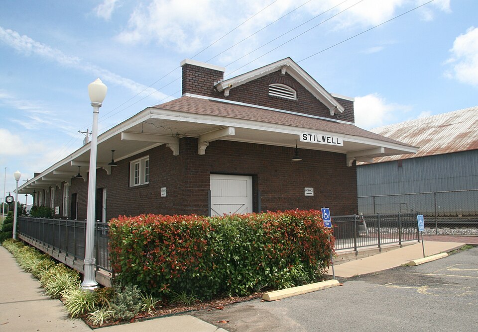
Built in 1915. Listed on the National Register of Historic Places in 2015.
One of 6 National Register listings published here for Adair County · listed in 2015 · category: Building · built in 1915.
Sources: the National Register database, National Park Service
Regional context, not property-specific evidence. The federal wildfire occurrence database lists 554 fires within 5 miles of KCS Railway Depot between 1992 and 2020, burning about 7,254 acres in total. 15 started naturally. 302 were recorded as arson. Distance is straight-line from the map coordinates, so a fire counted here may appear on a neighbouring settlement's page as well.
| Reported cause | Fires |
|---|---|
| Arson/incendiarism | 302 |
| Debris and open burning | 105 |
| Missing data/not specified/undetermined | 83 |
| Natural | 15 |
| Recreation and ceremony | 13 |
| Smoking | 13 |
| Equipment and vehicle use | 10 |
| Railroad operations and maintenance | 7 |
| Misuse of fire by a minor | 5 |
| Power generation/transmission/distribution | 1 |
The most recent of them, most recent first, with the day each was reported and the service that recorded it.
| Date | Cause | Size | Reported by | Name on the report |
|---|---|---|---|---|
| 9 September 2011 | Debris and open burning | 3.0 acres | Oklahoma Division of Forestry | 30470 |
| 6 September 2011 | Debris and open burning | under an acre | Oklahoma Division of Forestry | 30461 |
| 6 September 2010 | Arson/incendiarism | 26 acres | Oklahoma Division of Forestry | 30475 |
| 4 September 1998 | Missing data/not specified/undetermined | under an acre | Oklahoma Division of Forestry | not named |
| 4 September 1995 | Missing data/not specified/undetermined | 10 acres | Oklahoma Division of Forestry | not named |
| 23 September 2004 | Arson/incendiarism | under an acre | Oklahoma Division of Forestry | 30527 |
| 19 September 2000 | Recreation and ceremony | 2.0 acres | Oklahoma Division of Forestry | not named |
| 15 September 2000 | Railroad operations and maintenance | 7.0 acres | Oklahoma Division of Forestry | not named |
Regional context, not property-specific evidence. The federal mineral resources record lists 5 workings within 5 miles of KCS Railway Depot: 5 past producers. None of them still produces. What was taken out: Sand and Gravel, Construction. Distance is straight-line from the map coordinates, so a quarry counted here may appear on a neighbouring settlement's page as well.
| Where | Site | Commodity | Status | Recorded |
|---|---|---|---|---|
| Unknown Gravel Pit | Sand and Gravel, Construction | Past Producer | ||
| Unknown Gravel Pit | Sand and Gravel, Construction | Past Producer | ||
| Unknown Gravel Pit | Sand and Gravel, Construction | Past Producer | ||
| Unknown Gravel Pit | Sand and Gravel, Construction | Past Producer | ||
| Unknown Gravel Pit | Sand and Gravel, Construction | Past Producer |
Regional context, not property-specific evidence. The National Weather Service names Stilwell, the town this property stands in, in 107 storm reports between 1993 and 2025: 53 hail, 38 thunderstorm wind, 8 flash flood, 7 tornado. The reports record 1 death and 1 injury. Each account below is quoted exactly as the forecast office filed it, from the NOAA Storm Events Database, and each date opens the federal record of that event.
| When | Event | Place named | Harm | What the report says |
|---|---|---|---|---|
| June 1999 | Flash Flood | Stilwell | 1 killed, $5,000 | A 22-year old man drowned while attempting to cross a marked low-water bridge over Evansville Creek on OK Hwy 100 east of Stilwell. His compact pickup truck was swept off the road into the fast-moving stream, which had been flooded by up to 4 inches of rain earlier that morning upstream in Crawford and Washington Counties in Arkansas. The man's passenger managed to swim to safety, but the driver was carried downstream where his body was found several days later. |
| April 2022 | Tornado (EF1) | Stilwell | 1 hurt, $300,000 | This tornado developed south of the E 820 Road and west of the S 4700 Road, where large tree limbs were snapped and homes were damaged. It moved east-northeast across the cemetery snapping softwood trees. The tornado then moved across the northwest and north sides of Stilwell, where the roofs of a number of apartment buildings were damaged, homes were damaged, outbuildings were destroyed, trees were uprooted, and power poles were blown down. Several businesses were damaged as it crossed Highway 59, a semi truck was blown over, and trees were uprooted. As the tornado moved east-northeast from Stilwell, numerous trees were uprooted, outbuildings were damaged, and some trees and power poles were snapped from the S 4720 Road to near the S 4757 Road. The tornado appeared to dissipate just east of the S 4757 road. Based on this damage, maximum estimated wind in the tornado was 95 to 105 mph. |
| April 2021 | Tornado (EF1) | Stilwell | $50,000 | This tornado damaged a home, destroyed a couple outbuildings, damaged chicken houses, and uprooted trees. Based on this damage, maximum estimated wind in the tornado was 90 to 100 mph. |
| April 2008 | Tornado (EF2) | Stilwell | $50,000 | An NWS storm survey determined that a strong tornado destroyed a mobile home, caused extensive tree damage, and snapped power poles. This tornado continued into Washington County Arkansas, lifting about 4 miles southwest of Lincoln. |
| April 1995 | Thunderstorm Wind | Stilwell | $50,000 | no account filed |
| May 2019 | Thunderstorm Wind | Stilwell | $30,000 | Strong thunderstorm wind uprooted several trees and destroyed a large barn. |
| October 1995 | Tornado (F0) | Stilwell | $30,000 | no account filed |
| April 1999 | Thunderstorm Wind | Stilwell | $20,000 | Winds destroyed a barn, damaged roofs on chicken sheds, caused damage at the rodeo grounds, and caused minor damage to a mobile home. |
| May 2016 | Hail | Stilwell | $20,000 | no account filed |
| May 2011 | Hail | Stilwell | $15,000 | no account filed |
| March 2020 | Hail | Stilwell | $10,000 | no account filed |
| March 2017 | Hail | Stilwell | $10,000 | no account filed |
| May 1999 | Tornado (F3) | Stilwell | $7,000 | A significant long-track tornado first touched down in Sequoyah County 4 miles west of Short, moving northeast for 39 miles to a point about 7 miles southwest of Fayetteville, AR. This tornado clipped the extreme southeast portion of Adair County as the tornado reached its peak strength as an F3 tornado. Fortunately, the tornado travelled across an unpopulated portion of Adair County. However, an aerial survey by NWS personnel over extreme southeast Adair County revealed that every tree in a hardwood forest was completely leveled. |
| March 2020 | Thunderstorm Wind | Stilwell | $5,000 | Strong thunderstorm wind estimated to 70 mph damaged a gas station. |
| April 2016 | Thunderstorm Wind | Stilwell | $5,000 | Strong thunderstorm wind blew down trees and damaged a barn. |
| August 2002 | Thunderstorm Wind | Stilwell | $5,000 | Thunderstorm winds estimated at 70 miles an hour blew down trees and damaged two barns. |
| February 1999 | Thunderstorm Wind | Stilwell | $4,000 | A pole barn was destroyed by strong winds. |
| September 2001 | Thunderstorm Wind | Stilwell | $3,000 | Thunderstorm winds estimated at 70 miles an hour blew the roof off the press box of the football field and blew a few trees down. |
| June 2025 | Thunderstorm Wind | Stilwell | $2,000 | Strong thunderstorm wind blew down trees and power lines. |
| August 2014 | Thunderstorm Wind | Stilwell | $2,000 | Strong thunderstorm wind blew down power lines. |
| August 2009 | Thunderstorm Wind | Stilwell | $1,000 | Strong thunderstorm wind blew down large limbs and tore the gutters off a home. |
| May 2008 | Thunderstorm Wind | Stilwell | $1,000 | Thunderstorm winds estimated at 60 miles an hour blew down power lines. |
| May 1999 | Thunderstorm Wind | Stilwell | $700 | Several trees were snapped in half, and numerous tree limbs were blown down. |
| February 2001 | Thunderstorm Wind | Stilwell | $500 | Ozark Electric Company reported several large trees down causing power outages. |
| May 2000 | Thunderstorm Wind | Stilwell | $100 | Thunderstorm winds blew down a few trees. |
| May 2000 | Thunderstorm Wind | Stilwell | $100 | Thunderstorm winds blew down a few trees. |
| July 2000 | Thunderstorm Wind | Stilwell | $100 | Thunderstorm winds blew down a few large tree. |
| December 1999 | Thunderstorm Wind | Stilwell | $100 | Thunderstorm winds blew several large tree limbs down. |
| May 1997 | Thunderstorm Wind | Stilwell | $100 | no account filed |
| May 2024 | Tornado (EF2) | Stilwell | - | This is the first segment of a two-segment tornado. This tornado developed just west of the S 4735 Road, where trees were snapped and uprooted. It moved east-northeast, and produced extensive tree damage for about a mile and a half before crossing into Arkansas, just north of the Washington/Crawford County border. A tornadic debris signature was detected by the KSRX WSR-88D with this tornado. Based on this damage, maximum estimated wind in this segment of the tornado was 110 to 120 mph. |
| February 2023 | Flood | Stilwell | - | Portions of Highway 59 were flooded south of Stilwell. |
| June 2023 | Thunderstorm Wind | Stilwell | - | Strong thunderstorm wind snapped large tree limbs. |
| July 2020 | Thunderstorm Wind | Stilwell | - | Strong thunderstorm wind blew down trees. |
| March 2016 | Tornado (EF1) | Stilwell | - | This is the first segment of a three segment tornado. In Adair County, this tornado snapped or uprooted numerous trees. Based on this tree damage, maximum estimated wind in this segment of the tornado was 95 to 105 mph. The tornado continued into Crawford County, Arkansas. |
| April 2016 | Thunderstorm Wind | Stilwell | - | Strong thunderstorm wind snapped large tree limbs. |
| May 2015 | Flash Flood | Stilwell | - | Portions of the E 820 Road were flooded. |
| July 2014 | Thunderstorm Wind | Stilwell | - | Strong thunderstorm wind blew down several trees and numerous large tree limbs on county roads around Stilwell. |
| May 2011 | Thunderstorm Wind | Stilwell | - | A storm chaser estimated 60 mph thunderstorm wind gusts north of Stilwell. |
| April 2011 | Flash Flood | Stilwell | - | Many roads were flooded and impassable across the county. Travel into and around the county was discouraged by the emergency manager after two to four inches of rain fell in less than two hours on already saturated soil. |
| April 2008 | Flash Flood | Stilwell | - | Heavy rain caused water to flow over a bridge on Highway 51. |
| April 2008 | Flash Flood | Stilwell | - | Numerous county roads were flooded and closed. |
| March 2008 | Flash Flood | Stilwell | - | Heavy rain caused secondary roads to be flooded. |
| March 2008 | Thunderstorm Wind | Stilwell | - | Thunderstorm winds estimated at 70 miles an hour blew down a few trees. |
| March 2008 | Flash Flood | Stilwell | - | Heavy rain caused some secondary roads near Stilwell to be flooded. |
| April 2006 | Thunderstorm Wind | Stilwell | - | Thunderstorm winds estimated at 60 miles an hour blew down numerous large tree limbs. |
| September 2006 | Thunderstorm Wind | Stilwell | - | Thunderstorm winds estimated at 70 miles an hour uprooted a large tree and blew down several large tree limbs. |
| August 2006 | Thunderstorm Wind | Stilwell | - | Thunderstorm winds estimated at 70 miles an hour blew down three trees. |
| July 2003 | Thunderstorm Wind | Stilwell | - | Thunderstorm winds estimated at 60 miles an hour blew down tree limbs. |
| May 2003 | Thunderstorm Wind | Stilwell | - | Thunderstorm winds estimated at 70 miles an hour blew down a large tree. |
| October 2001 | Thunderstorm Wind | Stilwell | - | Thunderstorm winds estimated at 70 miles an hour blew a tree down. |
| September 1998 | Flash Flood | Stilwell | - | There was one foot of water over some county roads, and low water bridges were flooded. |
| June 1997 | Hail | Stilwell | - | Severe thunderstorms moved across northeast Oklahoma during the early morning of June 12th. Strong thunderstorm winds tore a small awning off a motor home and downed several large tree limbs at Cherokee Landing State Park 4 miles east of Pettit, and a privacy fence was blown down 3 miles northeast of Talala. 2 trees were blown down onto power lines in Ketchum, and a large tree was blown down across State Highway 82 4 miles north of Tahlequah. Trees were also blown down 5 miles east of Pryor, in Tahlequah, and 2 miles southeast of Tahlequah, and dime size hail fell at Stilwell. |
| May 1997 | Hail | Stilwell | - | Severe thunderstorms moved across northeast Oklahoma during the evening of May 7th and early morning of May 8th. The storms spawned 2 brief tornadoes, both in Osage County, and also produced damaging winds and large hail. The tornadoes touched down at 2037CST 7 miles west of Ralston and at 2102CST 1 mile southwest of Fairfax. The tornadoes both touched down in rural areas, and no structural damage occurred. The tornadoes were both rated F0 in intensity. Thunderstorm winds gusted to 60 miles an hour on the Creek/Tulsa County line 3 miles south southwest of Glenpool and in Bixby. Golfball size hail fell at Ralston, and quarter size hail fell at Fairfax, where the hail drifted to a depth of 11 inches in some places. Dime size hail fell at several other locations in northeast Oklahoma. The storms also produced very heavy rainfall which resulted in flash flooding in Osage and Pawnee Counties. A few roads were washed out 15 miles west southwest of Burbank, and many county roads were flooded near Maramec. |
| June 1995 | Hail | Stilwell | - | Thunderstorms reintensified to severe limits in northeast Oklahoma during the early afternoon of June 9th. Nickel-size hail fell in Pryor, dime-size hail fell four miles south of Stilwell, and strong thunderstorm winds downed numerous large tree limbs in Braggs. |
| June 1995 | Thunderstorm Wind | Stilwell | - | Severe thunderstorms moved across southeast and extreme east-central Oklahoma during the afternoon of June 5th. Strong thunderstorm winds downed trees and power lines in Poteau, and trees were blown down in Muldrow and in Westville. Thunderstorm winds gusted to 70 mph in McAlester, and several large tree limbs were blown down in Red Oak. Thunderstorm winds gusted to 60 to 65 mph six miles west of Wilburton and to 60 mph in Alderson, three miles southwest of Summerfield, and five miles southeast of Stilwell. Quarter-size hail fell at Alderson and four miles west of Kinta, and dime-size hail fell three miles southwest of Summerfield, at McCurtain, one mile south of Muldrow, and at Westville. Very heavy rainfall from the thunderstorms also resulted in flash flooding in Pittsburg and Le Flore Counties. Street flooding occurred in McAlester and also in Panama. |
| January 1995 | Hail | Stilwell | - | Severe thunderstorms developed in southeast Oklahoma during the evening of January 12th and moved north northeast into east-central Oklahoma. Large hail accompanied the storms, with golf ball-size hail at Roland and dime-size hail which covered the ground 10 miles north of Muldrow and at Keota. Dime-size hail also fell at several other locations in southeast and east-central Oklahoma. |
| July 1994 | Thunderstorm Wind | Stilwell | - | Severe thunderstorms developed in northeast Oklahoma during the evening of July 7th and continued into the early morning of July 8th. The storms produced four small, brief F-0 tornadoes in Osage County. The first tornado touched down briefly at 1942CST in open country 5 miles southeast of Foraker. The second tornado touched down briefly at 2007CST 5 miles northwest of Hominy. The third tornado touched down briefly at 2015CST 7 miles northwest of Hominy. The fourth tornado touched down briefly at 2023CST 5.5 miles north of Hominy. Thunderstorm winds gusted to 90 mph at Nowata, where numerous large trees were downed blocking some roads and signs were also downed. Thunderstorm winds gusted to 85 mph 10 miles west of Bartlesville, and quarter-size hail also fell at this location. A barn was damaged and numerous large trees were downed by 70-mph winds in Verdigris, and several large tree limbs and one tree with a 10 inch diameter trunk were downed by 70-mph winds in Welch. Strong thunderstorm winds pushed a large metal building off its foundation and downed numerous large trees in Miami, and power poles were downed 5 miles west of Jay. Thunderstorm winds downed trees, large tree limbs, and signs near New Alluwe, and numerous trees were downed in Stilwell. A large tree was toppled through a picture window of a house 4 miles east of Wagoner, and a large tree was downed near White Karen Cove in Wagoner County. A large tree was blown down onto power lines in Avant, and numerous large tree limbs were downed from just west of Skiatook in Osage County into Skiatook in Tulsa County. Thunderstorm winds gusted to 70 mph at Tahlequah and to 65 mph at Locust Grove and Wyandotte. Thunderstorm winds gusted to 60 mph 2 miles south of Wynona, at Avant, 3 miles north of Oologah, and 6 miles north of Claremore. Golfball-size hail fell at the intersection of 41st Street South and 145th East Avenue in the city of Tulsa, and at the intersection of 61st Street South and Elm Street in Broken Arrow. Half dollar-size hail fell at the intersection of 71st Street South and Kenosha Street in Broken Arrow. Dime to quarter-size hail fell at several other locations in northeast Oklahoma. |
| May 2025 | Hail | Stilwell | - | no account filed |
| April 2024 | Hail | Stilwell | - | no account filed |
| April 2017 | Hail | Stilwell | - | no account filed |
No historic map-sheet match is published for this property yet. That does not mean no map exists. This record needs a coordinate-quality review before it can be joined to a sheet boundary. Browse the county's mapped places while that work is pending.
Other National Register properties close enough to walk or drive between, ordered by distance from this one. Both positions come from the same geocoding pass that matched these properties to their map sheets.
| Photograph | Property | Distance | Listed |
|---|---|---|---|
 | Adair County Courthouse | 0.2 miles | 1984 |
| National Archives record | The nomination case file for reference 15000577 in Record Group 79. |
| Adair County | All 6 listed properties in this county. |