 Block
From the record
One of 36 National Register listings published here for Garfield County · listed in 2016 · category: Building · built in 1928, Colonial Revival architecture.
Sources: the National Register database, National Park Service
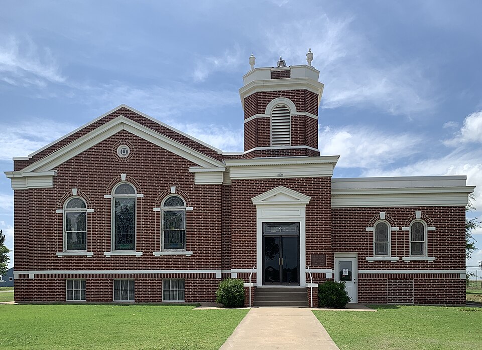
Built in 1928 (Colonial Revival architecture). Listed on the National Register of Historic Places in 2016.
One of 36 National Register listings published here for Garfield County · listed in 2016 · category: Building · built in 1928, Colonial Revival architecture.
Sources: the National Register database, National Park Service
Regional context, not property-specific evidence. The federal mineral resources record lists 8 workings within 5 miles of Carrier Congregational Church: 5 past producers, 2 producers, 1 occurrence. 2 still produce. What was taken out: Sand and Gravel, Construction, Copper. Distance is straight-line from the map coordinates, so a quarry counted here may appear on a neighbouring settlement's page as well.
| Where | Site | Commodity | Status | Recorded |
|---|---|---|---|---|
| Barnes Prospect | Copper | Occurrence | 1900 | |
| Enid Pit & Plant | Sand and Gravel, Construction | Producer | ||
| Unknown Sand Pit | Sand and Gravel, Construction | Past Producer | ||
| Unknown Sand Pit | Sand and Gravel, Construction | Producer | ||
| Unknown Sand Pit | Sand and Gravel, Construction | Past Producer | ||
| Unknown Sand Pit | Sand and Gravel, Construction | Past Producer | ||
| Unknown Sand Pit | Sand and Gravel, Construction | Past Producer | ||
| Unknown Sand Pit | Sand and Gravel, Construction | Past Producer |
Regional context, not property-specific evidence. The National Weather Service names Carrier, the town this property stands in, in 36 storm reports between 1997 and 2025: 17 hail, 9 thunderstorm wind, 5 tornado, 3 flash flood. No death or injury is recorded in these reports. Each account below is quoted exactly as the forecast office filed it, from the NOAA Storm Events Database, and each date opens the federal record of that event.
| When | Event | Place named | Harm | What the report says |
|---|---|---|---|---|
| April 1999 | Tornado (F2) | Carrier | $1,500,000 | no account filed |
| May 2015 | Flash Flood | Carrier | $50,000 | Several water rescues in stalled vehicles. |
| November 2024 | Flood | Carrier | $25,000 | Floodwaters washed out a bridge over a dry creek bed along West Willow Road on the 8th. Event time is approximate. |
| May 2017 | Thunderstorm Wind | Carrier | $20,000 | Approximately 22 utility poles were downed between Sheridan and Stable roads. Some trees were uprooted. Estimated 70 mph winds. Time estimate based on radar. |
| May 2016 | Tornado (EF2) | Carrier | $20,000 | A tornado was observed to develop approximately 3 miles west-northwest of Carrier and initially moved northeast. Near the beginning of the tornado path, 19 empty rail cars were blown from a siding onto the main line. A very large tree was downed across Great Lakes Road about 3/4 of a mile west of State Highway 132. Otherwise, the tornado traveled over wheat fields and the specific damage path is estimated, but chaser reports suggest the tornado turned north-northeast and then north after the initial northeast movement, and remained west of State Highway 132. |
| April 2009 | Thunderstorm Wind | Carrier | $15,000 | A pole barn was destroyed by severe thunderstorm winds from the east. |
| August 2009 | Thunderstorm Wind | Carrier | $10,000 | Several power lines from Carrier to Kremlin were downed by the strong winds. Monetary damages were estimated. |
| May 2019 | Lightning | Carrier | $5,000 | House struck by lightning between Wheatridge and Garland on Hwy 45. |
| May 2017 | Hail | Carrier | $5,000 | Hail damage reported to roofs and cars. Time estimated by radar. |
| April 1999 | Thunderstorm Wind | Carrier | $2,000 | no account filed |
| April 1999 | Thunderstorm Wind | Carrier | $500 | no account filed |
| September 1998 | Thunderstorm Wind | Carrier | $500 | no account filed |
| May 2024 | Hail | Carrier | - | Report of golf ball size hail from two miles west towards the center of the community of Carrier. Relayed by emergency management. |
| May 2015 | Tornado (EF0) | Carrier | - | Spotters and chasers observed a brief tornado estimated to have occurred about 2 miles south-southwest of Carrier. |
| May 2015 | Hail | Carrier | - | No damage reported. |
| June 2011 | Hail | Carrier | - | Nickel to quarter-size hail was reported. |
| June 2011 | Thunderstorm Wind | Carrier | - | Several tree limbs three to four inches in diameter were blown down. An arm from a railroad crossing sign was blown off. Monetary damage estimates were not available. |
| August 2009 | Flash Flood | Carrier | - | Portions of Highway 45 and 81, as well as numerous county roads north and west of Enid, were closed due to high water. Some of the roads remained through the morning hours. |
| April 2009 | Tornado (EF1) | Carrier | - | The tornado began about 3 miles south and 1 mile west of Hillsdale where a barn was destroyed just west of state highway 132. The tornado moved north-northeast through open farmland until it moved into an area southeast and east of Hillsdale where trees were damaged. Barns were damaged about one-half mile east of Hillsdale, with additional tree damage and damage to a house observed north-northeast of Hillsdale. |
| June 2008 | Flash Flood | Carrier | - | Highway 123 between Carrier and Hillsdale was closed due to water over the roadway. North State Road on the north side of Lahoma was also closed due to high water. |
| June 2007 | Hail | Carrier | - | The hail was reported quarter to golfball size. |
| September 2025 | Hail | Carrier | - | no account filed |
| May 2018 | Hail | Carrier | - | no account filed |
| April 2016 | Hail | Carrier | - | no account filed |
| April 2009 | Hail | Carrier | - | no account filed |
| April 2009 | Hail | Carrier | - | no account filed |
| May 2009 | Hail | Carrier | - | no account filed |
| July 2009 | Hail | Carrier | - | no account filed |
| August 2009 | Hail | Carrier | - | no account filed |
| June 2007 | Hail | Carrier | - | no account filed |
| May 2006 | Hail | Carrier | - | no account filed |
| June 2002 | Thunderstorm Wind | Carrier | - | no account filed |
| April 1999 | Tornado (F0) | Carrier | - | no account filed |
| April 1999 | Hail | Carrier | - | no account filed |
| May 1997 | Hail | Carrier | - | no account filed |
| March 1997 | Thunderstorm Wind | Carrier | - | no account filed |
No historic map-sheet match is published for this property yet. That does not mean no map exists. This record needs a coordinate-quality review before it can be joined to a sheet boundary. Browse the county's mapped places while that work is pending.
| National Archives record | The nomination case file for reference 16000370 in Record Group 79. |
| Garfield County | All 36 listed properties in this county. |