
BlockBefore
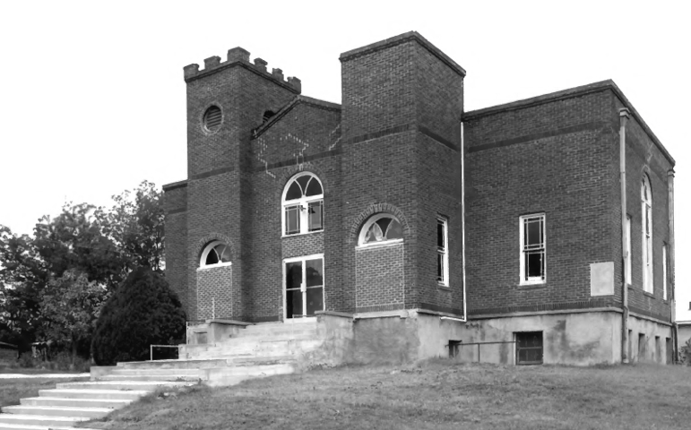
Photograph of Boley Historic District
Photograph by National Park Service, Public domain. Via Wikimedia Commons.

Boley Historic District

A National Historic Landmark. Listed on the National Register of Historic Places in 1975.

From the record

“The Boley Historic District (BHD), in Boley, Oklahoma is the original business area of an all-black town founded in 1903. The town of Boley prospered from the time of its incorporation until the onset of the Great Depression.”

Wikipedia article Boley Historic District, CC BY-SA 4.0.

One of 5 National Register listings published here for Okfuskee County · listed in 1975 · category: District · a National Historic Landmark.

Sources: the Wikipedia article · the case file at the National Archives · the National Register database, National Park Service

The listing

Fires near this property

33 since 2004

Regional context, not property-specific evidence. The federal wildfire occurrence database lists 33 fires within 5 miles of Boley Historic District between 2004 and 2020, burning about 8,586 acres in total. 1 started naturally. 11 were recorded as arson. Distance is straight-line from the map coordinates, so a fire counted here may appear on a neighbouring settlement's page as well.

Reported cause Fires
Arson/incendiarism11
Debris and open burning10
Missing data/not specified/undetermined8
Equipment and vehicle use2
Natural1
Power generation/transmission/distribution1

The most recent of them, most recent first, with the day each was reported and the service that recorded it.

DateCause SizeReported by Name on the report
6 July 2012Debris and open burning6.0 acresOkmulgee Field OfficeHILLIE
19 April 2006Arson/incendiarism150 acresOkmulgee Field OfficeTHORTON
10 April 2006Arson/incendiarism4,100 acresOkmulgee Field OfficeDANIELS
8 March 2015Debris and open burning10 acresOkmulgee Field OfficeOKFUSKEE
7 March 2015Debris and open burning68 acresOkmulgee Field OfficeWILLIAMSON
4 March 2007Debris and open burning1.2 acresOkmulgee Field OfficeBOLEY
31 March 2011Natural162 acresOkmulgee Field OfficeBOLE
26 March 2008Missing data/not specified/undetermined136 acresOkmulgee Field OfficeICY BRIDGE

Every fire recorded in Okfuskee County

Mines and quarries near this property

10 of 45 shown

Regional context, not property-specific evidence. The federal mineral resources record lists 45 workings within 5 miles of Boley Historic District: 45 past producers. None of them still produces. What was taken out: Sand and Gravel, Construction. Distance is straight-line from the map coordinates, so a quarry counted here may appear on a neighbouring settlement's page as well.

Where SiteCommodity StatusRecorded
Unknown Gravel PitSand and Gravel, ConstructionPast Producer

Every working recorded in Okfuskee County

Storms near this property

21 since 1993

Regional context, not property-specific evidence. The National Weather Service names Boley, the town this property stands in, in 21 storm reports between 1993 and 2017: 14 hail, 4 thunderstorm wind, 2 tornado, 1 flash flood. The reports record 4 injuries. Each account below is quoted exactly as the forecast office filed it, from the NOAA Storm Events Database, and each date opens the federal record of that event.

WhenEvent Place namedHarm What the report says
October 1998Tornado (F2)Boley4 hurt, $500,000A significant long-track tornado occurred on the evening of October 4, following a 27-mile track from 2 miles southeast of Boley in Okfuskee County to 3 miles southwest of Nuyaka in Okmulgee County. The tornado first touched down in Okfuskee County at 1037 PM CDT and lifted over Okmulgee County at 1108 PM CDT. (This Tornado entry covers that part of the track in Okfuskee County. See the separate Tornado entry for details on the portion in Okmulgee County.) The most significant damage to structures occurred near the communities of IXL and Haydenville, while much of the damage in the rural areas across which the tornado tracked consisted of downed/uprooted trees.In the small community of IXL, located on OK Hwy 48 north of Okemah, nearly every structure sustained at least some damage. An NWS Storm Survey revealed F2 damage at IXL, where a house and two mobile homes were destroyed. Pieces of one mobile home were found one-half mile away. A local newspaper also reported four businesses and a public building at the IXL Park were destroyed. Six houses and two more mobile homes sustained major damage, while another 21 houses and one mobile home sustained minor damage.In Haydenville, located north of Okemah on OK Hwy 56, two single-family houses and a mobile home were destroyed. Three houses, three mobile homes, and one public building (the Haydenville Fire Station) sustained major damage. Five houses and one business (the Haydenville Store) sustained minor damage. An NWS Storm Survey revealed F2 damage just southwest of Haydenville, where a mobile home was completely destroyed. Four people inside the trailer were injured, one of them critically. The tie-downs on the double-wide trailer were snapped, and the home appeared to have travelled a significant distance before disintegrating.This tornado was unusual for the fact that it covered such a large area. A survey showed that the damage path was at times 3 miles wide, lending credence to the idea that there were several smaller tornadoes circulating around the larger tornado. The larger tornado reached as wide as 8/10 of a mile.
May 2015Flash FloodBoley$100,000Several bridges within the city limits were washed out by flood water.
May 2010Tornado (EF1)Boley$40,000A tornado removed a large section of the roof of the Boley Police Department, damaged homes, snapped or uprooted numerous trees and blew down power poles. The estimated peak wind in the tornado based on this damage was 105 mph.
May 2010Thunderstorm WindBoley$4,000Strong thunderstorm wind blew down several power poles.
March 2015Thunderstorm WindBoley-Strong thunderstorm wind blew down trees and snapped large tree limbs north of Boley.
August 1998Thunderstorm WindBoley-At the correctional facility in Boley.
May 1995HailBoley-,,,,,,,,Thunderstorm Winds (G52)
April 2017HailBoley-no account filed
April 2011HailBoley-no account filed
May 2008HailBoley-no account filed
May 2002HailBoley-no account filed
May 1999HailBoley-no account filed
April 1996HailBoley-no account filed
April 1996Thunderstorm WindBoley-no account filed
October 1994HailBoley-no account filed
October 1993HailBoley-no account filed

Every storm recorded in Okfuskee County

Map coverage status

No historic map-sheet match is published for this property yet. That does not mean no map exists. This record needs a coordinate-quality review before it can be joined to a sheet boundary. Browse the county's mapped places while that work is pending.

Sources for this property

National Archives recordThe nomination case file for reference 75001568 in Record Group 79.
Wikipedia articleCommunity-written account of this property, licensed CC BY-SA.
Okfuskee CountyAll 5 listed properties in this county.

Provenance

  • Listing record. National Park Service National Register of Historic Places, listed-properties dataset, current to 2026-05-22.
  • Map join. Address geocoded through the United States Census geocoder, then tested against the published boundary of every sheet in the USGS Historical Topographic Map Collection.
  • How this page is made. Listing fields come from federal records; map-sheet coverage is a labelled coordinate-to-boundary calculation, not a source-field claim.
  • Wildfire. Short, Karen C. 2022. Spatial wildfire occurrence data for the United States, 1992-2020 [FPA_FOD_20221014]. 6th Edition. Fort Collins, CO: Forest Service Research Data Archive. https://doi.org/10.2737/RDS-2013-0009.6 Collected with United States Government funding and usable without additional permissions or fees.
  • Mines and quarries. USGS Mineral Resources Data System (MRDS) https://mrdata.usgs.gov/mrds/ A work of the United States government, no copyright under 17 U.S.C. 105.
  • Storms. NOAA National Centers for Environmental Information, Storm Events Database https://www.ncei.noaa.gov/stormevents/ A work of the United States government, no copyright under 17 U.S.C. 105. Narratives are quoted verbatim from the National Weather Service report and are not edited or summarised.