
BlockBefore
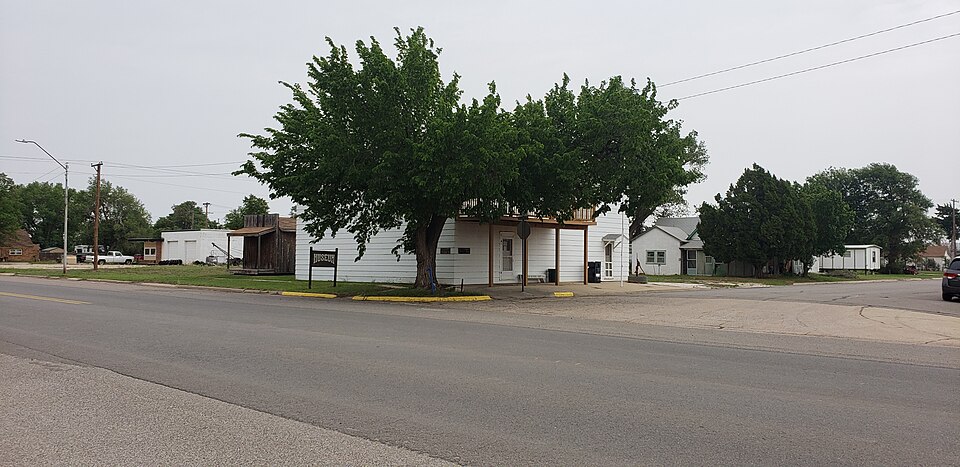
Photograph of Fox Hotel
Photograph by 25or6to4, CC BY-SA 4.0. Via Wikimedia Commons.

Fox Hotel

Built in 1912. Listed on the National Register of Historic Places in 1978.

From the record

“The Fox Hotel, at Broadway and NE 1st St. in Laverne, Oklahoma, is a historic hotel built in 1912. It was listed on the National Register of Historic Places in 1978.”

Wikipedia article Fox Hotel, CC BY-SA 4.0.

One of 13 National Register listings published here for Harper County · listed in 1978 · category: Building · built in 1912.

Sources: the Wikipedia article · the case file at the National Archives · the National Register database, National Park Service
The listing

  • What is counted as historic. The nomination lists 1 building as contributing to the listing.
  • Address. Broadway and NE 1st St., Laverne, 73848
  • When was it listed? January 1978
  • Category. building
  • Census division. Laverne
  • When was it built? 1912
  • National Register reference number. 78002236 - the number the National Park Service assigned this property when it was listed, and the key its nomination file is catalogued under at the National Archives.

Fires near this property

1 since 2017

Regional context, not property-specific evidence. The federal wildfire occurrence database lists 1 fire within 5 miles of Fox Hotel in 2017, burning about 69,396 acres in total. None started naturally. None was recorded as arson. Distance is straight-line from the map coordinates, so a fire counted here may appear on a neighbouring settlement's page as well.

Reported cause Fires
Missing data/not specified/undetermined1

The most recent of them, most recent first, with the day each was reported and the service that recorded it.

DateCause SizeReported by Name on the report
7 March 2017Missing data/not specified/undetermined69,396 acresOklahoma Division of ForestryOKS - 283

Every fire recorded in Harper County

Mines and quarries near this property

4 within 5 miles

Regional context, not property-specific evidence. The federal mineral resources record lists 4 workings within 5 miles of Fox Hotel: 3 past producers, 1 producer. 1 still produces. What was taken out: Sand and Gravel, Construction. Distance is straight-line from the map coordinates, so a quarry counted here may appear on a neighbouring settlement's page as well.

Where SiteCommodity StatusRecorded
Unknown Gravel PitSand and Gravel, ConstructionPast Producer
Unknown Gravel PitSand and Gravel, ConstructionProducer
Unknown Gravel PitsSand and Gravel, ConstructionPast Producer

Every working recorded in Harper County

Storms near this property

60 of 125 shown

Regional context, not property-specific evidence. The National Weather Service names Laverne, the town this property stands in, in 125 storm reports between 1993 and 2025: 90 hail, 27 thunderstorm wind, 5 tornado, 3 lightning. No death or injury is recorded in these reports. Each account below is quoted exactly as the forecast office filed it, from the NOAA Storm Events Database, and each date opens the federal record of that event.

WhenEvent Place namedHarm What the report says
June 2023Thunderstorm WindLaverne$250,000As a tornado was dissipating north of Laverne, damaging winds from this supercell produced widespread roof, tree and power line damage in Laverne. A number of homes and buildings throughout town suffered roof damage, and multiple power poles were downed in Laverne as well as to the east along State Highway 149.
June 2002Thunderstorm WindLaverne$30,000Seven power poles were snapped in half. A mobile home was overturned, and a large barn was destroyed.
May 2019Tornado (EF2)Laverne$20,000This tornado developed in Lipscomb County Texas and moved through Beaver and Ellis Counties in Oklahoma before moving into southwestern Harper County. The tornado broke numerous power poles and damaged trees as it moved northeast, crossing US Highway 412/State Highway 3, and dissipated about one mile north of the highway to the southwest of Laverne.
April 2004LightningLaverne$15,000Lightning caused a tank battery to catch on fire.
April 2004LightningLaverne$15,000A tank battery caught on fire due to a lightning strike.
August 2024Thunderstorm WindLaverne$5,000Powerlines blown down along U.S. Highway 270. Time is radar estimated.
June 2008Thunderstorm WindLaverne$5,000Tree limbs and power lines were blown down by the strong winds. Monetary damages were estimated.
August 2002LightningLaverne$5,000Lightning struck a building and a storage tank.
August 2002Thunderstorm WindLaverne$3,000Power poles were downed.
May 2005HailLaverne$2,500Several car windows were broken.
February 2000Tornado (F0)Laverne$2,000This is a continuation of the Lipscomb/Ellis County tornado.
June 2010Thunderstorm WindLaverne$1,000Several tree limbs were downed by the strong winds. Monetary damages were estimated.
July 2005Thunderstorm WindLaverne$500Tree limbs, two to three inches in diameter, were downed.
August 1997Thunderstorm WindLaverne$500Power lines and tree limbs up to six inches in diameter were blown down. Part of a roof was blown off of a building.
May 1996Thunderstorm WindLaverne$10no account filed
May 2025HailLaverne-The report was relayed through mPING.
May 2025HailLaverne-The event time is estimated from radar observations.
August 2025Thunderstorm WindLaverne-A personal weather station observation. The event time is estimated from radar observations.
September 2025HailLaverne-The location is approximate.
June 2019HailLaverne-Dispach reported dime size hail. Time is radar estimate.
May 2019Tornado (EFU)Laverne-Spotters observed a tornado from a second storm southwest of Laverne. No damage was noted that could be distinguished as independent from the initial tornado in the area, therefore the location of this tornado was estimated.
June 2018Thunderstorm WindLaverne-Also reported quarter size hail.
October 2017Thunderstorm WindLaverne-The wind gust was estimated by an official cooperative observer.
June 2016Thunderstorm WindLaverne-Eight inch diameter tree limb was snapped by high wind gusts.
July 2016Thunderstorm WindLaverne-No damage reported.
June 2014Thunderstorm WindLaverne-Numerous downed trees and minor structural damage to some homes and carports occurred. Time of damage estimated from radar. No damage estimated were available.
June 2013Thunderstorm WindLaverne-Public estimated a gust to 60 mph.
July 2010Thunderstorm WindLaverne-Nickel-size hail was also reported with the wind gust.
July 2010HailLaverne-A wind gust to 60 mph was also reported with the hail.
October 2008HailLaverne-The hail was reported by the Harper county Emergency Manager.
May 2008HailLaverne-The report was relayed by an Oklahoma City television station Storm Tracker.
April 2007HailLaverne-Hail fell for approximately 10 minutes.
April 2007Tornado (EF0)Laverne-An off-duty NWS meteorologist observed a tornado approximately 4 miles northeast of Laverne. No damage was reported.
May 2007HailLaverne-Reported at Log Cabin Corner.
May 2007HailLaverne-Reported at HWY 283.
March 1995HailLaverne-On the evening of the 25th, thunderstorms developed along a dryline in southwest Oklahoma. One of these storms became severe and produced hail up to three-quarters inch in Harper County.
July 1994HailLaverne-An isolated severe thunderstorm in northwest Oklahoma during the afternoon of the 22nd produced hail up to dime-size.
September 1993HailLaverne-Severe thunderstorms developed in the Oklahoma panhandle during the late afternoon and evening hours on the 18th and moved eastward into extreme northwest Oklahoma. The storms produced one tornado, hail up to 3.00 inches in diameter and strong winds. The tornado developed 6 miles east-southeast of Elmwood at 1814 CST. The tornado traveled 0.5 miles before dissipating at 1818 CST. This F0 tornado damaged several power poles and broke out some windows. Large hail broke out windows in Hardesty and Bryans Corner.
September 2021Thunderstorm WindLaverne-no account filed
July 2020HailLaverne-no account filed
May 2016HailLaverne-no account filed
June 2014HailLaverne-no account filed
August 2013HailLaverne-no account filed
May 2013HailLaverne-no account filed
April 2012HailLaverne-no account filed
June 2009HailLaverne-no account filed
March 2008HailLaverne-no account filed
May 2008HailLaverne-no account filed
June 2008HailLaverne-no account filed
June 2008Thunderstorm WindLaverne-no account filed
May 2008HailLaverne-no account filed

Every storm recorded in Harper County

Map coverage status

No historic map-sheet match is published for this property yet. That does not mean no map exists. This record needs a coordinate-quality review before it can be joined to a sheet boundary. Browse the county's mapped places while that work is pending.

Listed places nearby

4 within 8 miles

Other National Register properties close enough to walk or drive between, ordered by distance from this one. Both positions come from the same geocoding pass that matched these properties to their map sheets.

Photograph PropertyDistance Listed
Sharp Lumberyardunder 500 feet1984
Laverne's North Main Street Districtunder 500 feet1984
M.K. and T. Depot in Laverne0.1 miles1984
Clover Hotel0.2 miles1984

Sources for this property

National Archives recordThe nomination case file for reference 78002236 in Record Group 79.
Wikipedia articleCommunity-written account of this property, licensed CC BY-SA.
Harper CountyAll 13 listed properties in this county.

Provenance

  • Listing record. National Park Service National Register of Historic Places, listed-properties dataset, current to 2026-05-22.
  • Map join. Address geocoded through the United States Census geocoder, then tested against the published boundary of every sheet in the USGS Historical Topographic Map Collection.
  • How this page is made. Listing fields come from federal records; map-sheet coverage is a labelled coordinate-to-boundary calculation, not a source-field claim.
  • Wildfire. Short, Karen C. 2022. Spatial wildfire occurrence data for the United States, 1992-2020 [FPA_FOD_20221014]. 6th Edition. Fort Collins, CO: Forest Service Research Data Archive. https://doi.org/10.2737/RDS-2013-0009.6 Collected with United States Government funding and usable without additional permissions or fees.
  • Mines and quarries. USGS Mineral Resources Data System (MRDS) https://mrdata.usgs.gov/mrds/ A work of the United States government, no copyright under 17 U.S.C. 105.
  • Storms. NOAA National Centers for Environmental Information, Storm Events Database https://www.ncei.noaa.gov/stormevents/ A work of the United States government, no copyright under 17 U.S.C. 105. Narratives are quoted verbatim from the National Weather Service report and are not edited or summarised.