 Block
From the record
One of 23 National Register listings published here for Okmulgee County · listed in 1981 · category: Building.
Sources: the case file at the National Archives · the National Register database, National Park Service
Listed on the National Register of Historic Places in 1981.
One of 23 National Register listings published here for Okmulgee County · listed in 1981 · category: Building.
Sources: the case file at the National Archives · the National Register database, National Park Service
Regional context, not property-specific evidence. The federal wildfire occurrence database lists 68 fires within 5 miles of Wilson School between 2003 and 2020, burning about 7,806 acres in total. 1 started naturally. 26 were recorded as arson. Distance is straight-line from the map coordinates, so a fire counted here may appear on a neighbouring settlement's page as well.
| Reported cause | Fires |
|---|---|
| Arson/incendiarism | 26 |
| Debris and open burning | 19 |
| Missing data/not specified/undetermined | 12 |
| Equipment and vehicle use | 6 |
| Fireworks | 2 |
| Power generation/transmission/distribution | 1 |
| Misuse of fire by a minor | 1 |
| Natural | 1 |
The most recent of them, most recent first, with the day each was reported and the service that recorded it.
| Date | Cause | Size | Reported by | Name on the report |
|---|---|---|---|---|
| 30 September 2008 | Misuse of fire by a minor | under an acre | Okmulgee Field Office | MONTEZUMA CREEK |
| 20 September 2004 | Debris and open burning | 250 acres | Okmulgee Field Office | OKM SUPPOR |
| 19 September 2004 | Debris and open burning | 80 acres | Okmulgee Field Office | LHE |
| 1 August 2012 | Arson/incendiarism | 2.9 acres | Deep Fork National Wildlife Refuge | GIBBONS RANCH FIRE |
| 5 July 2012 | Fireworks | under an acre | Deep Fork National Wildlife Refuge | SHARP ROAD MOUND |
| 24 July 2011 | Equipment and vehicle use | 127 acres | Okmulgee Field Office | SALT CREEK |
| 23 July 2019 | Arson/incendiarism | under an acre | Deep Fork National Wildlife Refuge | SHARP ROAD |
| 23 July 2011 | Fireworks | 8.0 acres | Okmulgee Field Office | BIRD CREEK |
Regional context, not property-specific evidence. The federal mineral resources record lists 7 workings within 5 miles of Wilson School: 7 past producers. None of them still produces. What was taken out: Stone, Crushed/Broken, Clay, Sand and Gravel, Construction. Distance is straight-line from the map coordinates, so a quarry counted here may appear on a neighbouring settlement's page as well.
| Where | Site | Commodity | Status | Recorded |
|---|---|---|---|---|
| Unknown Sand Pit | Sand and Gravel, Construction | Past Producer | ||
| Unknown Shale Pit | Clay | Past Producer | ||
| Unknown Shale Pit | Clay | Past Producer | ||
| Unknown Sandstone Pit | Stone, Crushed/Broken | Past Producer | ||
| Unknown Sandstone Pit | Stone, Crushed/Broken | Past Producer | ||
| Unknown Sandstone Pit | Stone, Crushed/Broken | Past Producer | ||
| Unknown Sandstone Pit | Stone, Crushed/Broken | Past Producer |
Regional context, not property-specific evidence. The National Weather Service names Henryetta, the town this property stands in, in 99 storm reports between 1995 and 2025: 43 hail, 37 thunderstorm wind, 14 flash flood, 3 tornado. No death or injury is recorded in these reports. Each account below is quoted exactly as the forecast office filed it, from the NOAA Storm Events Database, and each date opens the federal record of that event.
| When | Event | Place named | Harm | What the report says |
|---|---|---|---|---|
| June 2013 | Flash Flood | Henryetta | $250,000 | Many streets and roads were flooded and closed due to significant flooding. A nursing home and about 25 homes were evacuated due to rising water in Henryetta and about 50 homes were impacted by flooding in Dewar. |
| May 2003 | Tornado (F1) | Henryetta | $100,000 | A tornado touched down southwest of Henryetta and moved northeast crossing Interstate 40 before dissipating on the west side of the city. Twenty homes in Henryetta suffered roof damage. One business had aluminum siding ripped off of it. Numerous trees were also blown down in Henryetta making several streets impassable. |
| May 1999 | Thunderstorm Wind | Henryetta | $45,000 | Strong winds blew a roof completely off of a muffler shop in the 900 block of North Frisco. The roof hit a power feeder and knocked off power to a large part of the city. One of the businesses's doors was blown off as well. Several businesses reported windows blown out by the storm, and numerous trees and tree limbs were blown down. |
| March 2025 | Tornado (EF1) | Henryetta | $40,000 | This tornado developed south of New Lake Road and east of the S 230 Road, where trees were snapped. It moved northeast across I-40, crossed Holly Road damaging outbuildings, and then Arbeka Road, where large tree limbs were snapped. It then dissipated north of Holly Road and east of Arbeka Road. Based on this damage, maximum estimated wind in the tornado was 90 to 95 mph. |
| May 1998 | Lightning | Henryetta | $30,000 | Lightning struck a TV antenna and set fire to a residence in Henryetta. The home was about a 50 percent loss. |
| June 2005 | Thunderstorm Wind | Henryetta | $25,000 | Thunderstorm winds estimated at 75 miles an hour caused roof damage and blew out the windows of a business. |
| May 2006 | Hail | Henryetta | $25,000 | no account filed |
| April 2025 | Hail | Henryetta | $20,000 | Ping pong ball size hail damaged homes and vehicles. |
| September 2023 | Hail | Henryetta | $20,000 | Golf ball size hail damaged homes and vehicles. |
| May 2019 | Thunderstorm Wind | Henryetta | $20,000 | Strong thunderstorm wind blew down trees, some onto homes, and damaged carports. |
| June 2007 | Flash Flood | Henryetta | $20,000 | Heavy rain caused flooding which required persons in 20 homes near DeWar to be evacuated. Significant street flooding occurred in the city of Henryetta. |
| March 1996 | Thunderstorm Wind | Henryetta | $20,000 | no account filed |
| September 2017 | Thunderstorm Wind | Henryetta | $15,000 | Strong thunderstorm wind blew out five industrial sized garage doors of a county storage barn, snapped numerous tree limbs, and damaged another barn. |
| August 2010 | Thunderstorm Wind | Henryetta | $15,000 | Strong thunderstorm wind blew off the roof of a barn, damaged a mobile home, and blew down large tree limbs. |
| August 2007 | Flash Flood | Henryetta | $10,000 | Heavy rain caused Highway 75 to be flooded north of Henryetta. The flooding caused several cars to be stranded.| |
| May 2000 | Thunderstorm Wind | Henryetta | $10,000 | Thunderstorm winds blew a tree onto a house. |
| May 1999 | Flash Flood | Henryetta | $10,000 | Several roads in Dewar and Henryetta were closed between 230 AM and 500 AM CDT. Coal Creek overflowed its banks and closed OK Hwy 266 for a time around 1000 to 1030 AM CDT. Seven houses near the tennis courts on Lake Road had to be evacuated. A home on South Fourt in Henryetta was flooded. |
| May 2010 | Hail | Henryetta | $10,000 | no account filed |
| June 2008 | Hail | Henryetta | $10,000 | no account filed |
| November 2022 | Thunderstorm Wind | Henryetta | $5,000 | Strong thunderstorm wind snapped large tree limbs and blew shingles from the roof of a home. |
| July 2012 | Thunderstorm Wind | Henryetta | $5,000 | Strong thunderstorm wind damaged the roof of a home and blew down trees. |
| August 2009 | Thunderstorm Wind | Henryetta | $5,000 | Strong thunderstorm wind blew down power lines. |
| May 2001 | Thunderstorm Wind | Henryetta | $5,000 | Thunderstorm winds blew the roof off a barn and onto power lines. |
| June 1998 | Thunderstorm Wind | Henryetta | $5,000 | There was wind damage to a restaurant and motel in Henryetta. |
| March 1997 | Thunderstorm Wind | Henryetta | $5,000 | no account filed |
| April 1995 | Thunderstorm Wind | Henryetta | $5,000 | no account filed |
| March 1999 | Lightning | Henryetta | $4,000 | A home in Henryetta was hit by lightning. The lightning blew siding off the house, bent an antenna, damaged the central heat/air, and destroyed several small appliances. |
| June 2004 | Thunderstorm Wind | Henryetta | $3,000 | Thundestorm winds estimated at 60 miles an hour blew down large tree limbs and power lines. |
| November 1999 | Thunderstorm Wind | Henryetta | $3,000 | Trees and power lines were blown down on the northeast side of Henryetta. |
| October 2010 | Thunderstorm Wind | Henryetta | $2,000 | Strong thunderstorm wind blew down several trees, heavily damaged two tin barns, and damaged the shingles of a home. |
| May 1999 | Thunderstorm Wind | Henryetta | $2,000 | A newspaper clipping showed a picture of a large tree that fell on a home just west of Henryetta. Otherwise, numerous tree limbs were blown down. |
| August 2006 | Thunderstorm Wind | Henryetta | $1,000 | Thunderstorm winds estimated at 60 miles an hour blew down large tree limbs. Some of the tree limbs knocked down power lines. |
| April 1996 | Thunderstorm Wind | Henryetta | $1,000 | no account filed |
| May 1999 | Thunderstorm Wind | Henryetta | $500 | A tree and several tree limbs were blown down. |
| April 2001 | Thunderstorm Wind | Henryetta | $100 | Thunderstorm wind blew down large tree limbs. |
| May 2001 | Thunderstorm Wind | Henryetta | $100 | Thunderstorms winds blew down several large tree limbs. |
| June 1996 | Thunderstorm Wind | Henryetta | $100 | no account filed |
| April 2025 | Thunderstorm Wind | Henryetta | - | Thunderstorm wind gusts were estimated to 60 mph. |
| April 2024 | Thunderstorm Wind | Henryetta | - | Thunderstorm wind gusts were estimated to 60 mph in Henryetta. |
| June 2021 | Flash Flood | Henryetta | - | Portions of several county roads were flooded and closed. |
| April 2017 | Thunderstorm Wind | Henryetta | - | Strong thunderstorm wind snapped large tree limbs. |
| July 2016 | Thunderstorm Wind | Henryetta | - | Strong thunderstorm wind blew down numerous large tree limbs. |
| July 2016 | Flash Flood | Henryetta | - | Main Street in Henryetta was closed due to water over the roadway. |
| May 2015 | Flash Flood | Henryetta | - | Several streets were closed due to high water. Lake Drive Nursing Home was evacuated, along with several homes, due to rapidly rising water. |
| June 2013 | Flash Flood | Henryetta | - | Highway 75B at 4th Street was closed due to flooding. |
| May 2011 | Thunderstorm Wind | Henryetta | - | Trees were blown down by strong thunderstorm winds. |
| January 2008 | Flash Flood | Henryetta | - | Heavy rains caused flooding of secondary roads near Henryetta. |
| March 2008 | Flash Flood | Henryetta | - | Heavy rain caused flooding on South 1st Street and the Lake Road area. |
| July 2007 | Thunderstorm Wind | Henryetta | - | Thunderstorm winds estimated at 70 miles an hour blew down two trees. |
| August 2001 | Flash Flood | Henryetta | - | Heavy thunderstorm rains caused police to close Frisco Road due to high water. |
| April 1999 | Flash Flood | Henryetta | - | There was street flooding in Henryetta. |
| May 1998 | Flash Flood | Henryetta | - | Water covered the east end of Main Street in Henryetta. The street had to be closed for a time. The NWS cooperative observer 2 miles northeast of Dewar reported 2.50 inches of rain. |
| May 1998 | Hail | Henryetta | - | Report from downtown Henryetta |
| June 1998 | Hail | Henryetta | - | Location: intersection of I-40 and US Hwy 75 |
| March 1997 | Hail | Henryetta | - | Severe thunderstorms moved across northeast Oklahoma during the late evening of March 24th and early morning of March 25th. Thunderstorm winds estimated at 70 miles an hour caused considerable damage in Hominy, where windows were blown out, roofs were damaged, and signs, trees, and large tree limbs were blown down. The roof was partially blown off 1 building, and a large overhead door was blown in at another business. Siding was damaged at 1 house, and another house received porch damage. A tree was blown down onto a bus at the Assembly of God Church in Hominy.Strong thunderstorm winds blew the roofs off several homes and buildings and blew out windows in Okmulgee, and a mobile home was destroyed by strong winds 1 mile north of Terlton. An outbuilding was blown over and large tree limbs were downed in Oilton, and a large tree was blown down across State Highway 85 2 miles southwest of Cleora. Strong winds blew down a 24 foot tall, 2 foot diameter tree 6 miles northwest of Jay, and 70 mile an hour thunderstorm winds downed 4 to 6 inch diameter tree limbs and a few signs in Cleveland. Thunderstorm winds gusted to 75 miles an hour 2 miles southwest of Collinsville and to 59 to 70 miles an hour at numerous other locations in northeast Oklahoma. Golfball size hail fell 10 miles east of Ponca City, at Pawhuska, at Hominy, at Osage Hills State Park 9 miles northeast of Pawhuska, and 3 miles west of Nowata. Dime size hail fell for 20 minutes at Henryetta, and dime to quarter size hail also fell at numerous other locations in northeast Oklahoma. |
| July 2018 | Hail | Henryetta | - | no account filed |
| March 2016 | Hail | Henryetta | - | no account filed |
| March 2013 | Hail | Henryetta | - | no account filed |
| May 2011 | Hail | Henryetta | - | no account filed |
| June 2009 | Hail | Henryetta | - | no account filed |
No historic map-sheet match is published for this property yet. That does not mean no map exists. This record needs a coordinate-quality review before it can be joined to a sheet boundary. Browse the county's mapped places while that work is pending.
Other National Register properties close enough to walk or drive between, ordered by distance from this one. Both positions come from the same geocoding pass that matched these properties to their map sheets.
| Photograph | Property | Distance | Listed |
|---|---|---|---|
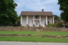 | Hugh Henry House | 4.9 miles | 1983 |
| First Presbyterian Church | 5.3 miles | 2026 | |
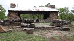 | Nichols Park | 7.7 miles | 2006 |
| National Archives record | The nomination case file for reference 81000465 in Record Group 79. |
| Okmulgee County | All 23 listed properties in this county. |