 Block
From the record
One of 9 National Register listings published here for Ellis County · listed in 1983 · category: Building.
Sources: the case file at the National Archives · the National Register database, National Park Service
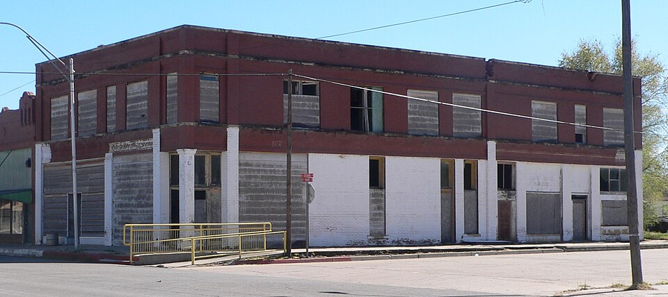
Listed on the National Register of Historic Places in 1983.
One of 9 National Register listings published here for Ellis County · listed in 1983 · category: Building.
Sources: the case file at the National Archives · the National Register database, National Park Service
Regional context, not property-specific evidence. The federal mineral resources record lists 5 workings within 5 miles of Bank of Gage: 5 past producers. None of them still produces. What was taken out: Limestone, General. Distance is straight-line from the map coordinates, so a quarry counted here may appear on a neighbouring settlement's page as well.
| Where | Site | Commodity | Status | Recorded |
|---|---|---|---|---|
| Unknown Caliche Pit | Limestone, General | Past Producer | ||
| Unknown Caliche Pit | Limestone, General | Past Producer | ||
| Unknown Caliche Pit | Limestone, General | Past Producer | ||
| Unknown Caliche Pit | Limestone, General | Past Producer | ||
| Unknown Caliche Pit | Limestone, General | Past Producer |
Regional context, not property-specific evidence. The National Weather Service names Gage, the town this property stands in, in 70 storm reports between 1993 and 2024: 35 hail, 30 thunderstorm wind, 3 flash flood, 2 heavy rain. No death or injury is recorded in these reports. Each account below is quoted exactly as the forecast office filed it, from the NOAA Storm Events Database, and each date opens the federal record of that event.
| When | Event | Place named | Harm | What the report says |
|---|---|---|---|---|
| September 2012 | Thunderstorm Wind | Gage | $45,000 | Emergency manager reported outbuildings were damaged, a mobile home was blown off its foundation, and power lines were downed. |
| June 2003 | Thunderstorm Wind | Gage | $35,000 | Straight-line winds toppled approximately a half a mile of cars of a Burlington Northern Santa Fe train. |
| August 2020 | Thunderstorm Wind | Gage | $25,000 | Train derailment with 15-20 train cars off tracks. |
| July 2013 | Thunderstorm Wind | Gage | $3,000 | Post Office employee reported 6-8 inch diameter branches down. Other numerous smaller branches were down between Gage and Fargo. |
| July 2005 | Thunderstorm Wind | Gage | $1,000 | Six to seven inch diameter tree limbs were downed. |
| May 2003 | Thunderstorm Wind | Gage | $50 | Several three inch diameter tree limbs were downed. |
| July 2013 | Thunderstorm Wind | Gage | - | KGAG recorded a gust to 59 mph. |
| May 2012 | Thunderstorm Wind | Gage | - | A heat burst within the anvil of the parent thunderstorm generated a 62 mph wind gust. No damage was reported. |
| May 2012 | Thunderstorm Wind | Gage | - | A heat burst within the anvil of the parent storm generated a 61 mph wind gust. No damage was reported. |
| September 2012 | Thunderstorm Wind | Gage | - | The ASOS at Gage recorded a wind gust to 81 mph at 5:49pm CDT. A wind gust to 71 mph was also recorded five minutes earlier at 5:44pm CDT. |
| June 2003 | Heavy Rain | Gage | - | A low area along Highway 15 in Gage was covered by floodwaters to a depth of about one foot. |
| August 2002 | Thunderstorm Wind | Gage | - | Wind was measured by the Oklahoma mesonet. |
| October 2000 | Flash Flood | Gage | - | Numerous streets were flooded. |
| May 1997 | Flash Flood | Gage | - | State Highway 46 was under water due to flash flooding. |
| May 1997 | Flash Flood | Gage | - | Three feet of water covered State Highway 46. |
| May 2024 | Hail | Gage | - | no account filed |
| May 2024 | Hail | Gage | - | no account filed |
| June 2018 | Thunderstorm Wind | Gage | - | no account filed |
| June 2018 | Thunderstorm Wind | Gage | - | no account filed |
| June 2018 | Thunderstorm Wind | Gage | - | no account filed |
| July 2017 | Thunderstorm Wind | Gage | - | no account filed |
| July 2013 | Thunderstorm Wind | Gage | - | no account filed |
| May 2013 | Hail | Gage | - | no account filed |
| April 2012 | Hail | Gage | - | no account filed |
| March 2012 | Hail | Gage | - | no account filed |
| June 2011 | Thunderstorm Wind | Gage | - | no account filed |
| May 2010 | Thunderstorm Wind | Gage | - | no account filed |
| May 2010 | Hail | Gage | - | no account filed |
| May 2010 | Thunderstorm Wind | Gage | - | no account filed |
| April 2009 | Hail | Gage | - | no account filed |
| May 2008 | Hail | Gage | - | no account filed |
| May 2007 | Hail | Gage | - | no account filed |
| June 2007 | Heavy Rain | Gage | - | no account filed |
| June 2007 | Hail | Gage | - | no account filed |
| May 2007 | Hail | Gage | - | no account filed |
| April 2004 | Hail | Gage | - | no account filed |
| June 2004 | Hail | Gage | - | no account filed |
| June 2002 | Hail | Gage | - | no account filed |
| June 2002 | Hail | Gage | - | no account filed |
| August 2002 | Hail | Gage | - | no account filed |
| April 2001 | Thunderstorm Wind | Gage | - | no account filed |
| May 2001 | Thunderstorm Wind | Gage | - | no account filed |
| May 2001 | Hail | Gage | - | no account filed |
| August 2001 | Thunderstorm Wind | Gage | - | no account filed |
| October 2000 | Hail | Gage | - | no account filed |
| July 2000 | Thunderstorm Wind | Gage | - | no account filed |
| September 1999 | Thunderstorm Wind | Gage | - | no account filed |
| April 1999 | Hail | Gage | - | no account filed |
| April 1999 | Hail | Gage | - | no account filed |
| May 1999 | Thunderstorm Wind | Gage | - | no account filed |
| May 1999 | Hail | Gage | - | no account filed |
| July 1998 | Thunderstorm Wind | Gage | - | no account filed |
| June 1997 | Hail | Gage | - | no account filed |
| May 1997 | Hail | Gage | - | no account filed |
| May 1997 | Hail | Gage | - | no account filed |
| May 1997 | Hail | Gage | - | no account filed |
| May 1997 | Hail | Gage | - | no account filed |
| May 1996 | Thunderstorm Wind | Gage | - | no account filed |
| July 1996 | Thunderstorm Wind | Gage | - | no account filed |
| June 1995 | Hail | Gage | - | no account filed |
No historic map-sheet match is published for this property yet. That does not mean no map exists. This record needs a coordinate-quality review before it can be joined to a sheet boundary. Browse the county's mapped places while that work is pending.
Other National Register properties close enough to walk or drive between, ordered by distance from this one. Both positions come from the same geocoding pass that matched these properties to their map sheets.
| Photograph | Property | Distance | Listed |
|---|---|---|---|
 | Shattuck National Bank Building | 7.6 miles | 1983 |
| First State Bank | 7.6 miles | 1983 | |
| Ingle Brothers Broomcorn Warehouse | 7.6 miles | 2009 |
| National Archives record | The nomination case file for reference 83004169 in Record Group 79. |
| Ellis County | All 9 listed properties in this county. |