 Block
From the record
One of 28 National Register listings published here for Cleveland County · listed in 1984 · category: Building · built in 1928.
Sources: the case file at the National Archives · the National Register database, National Park Service
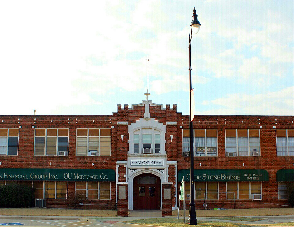
Built in 1928. Listed on the National Register of Historic Places in 1984.
One of 28 National Register listings published here for Cleveland County · listed in 1984 · category: Building · built in 1928.
Sources: the case file at the National Archives · the National Register database, National Park Service
Regional context, not property-specific evidence. The federal wildfire occurrence database lists 1 fire within 5 miles of Moore Public School Building in 2006, burning about 1,500 acres in total. None started naturally. None was recorded as arson. Distance is straight-line from the map coordinates, so a fire counted here may appear on a neighbouring settlement's page as well.
| Reported cause | Fires |
|---|---|
| Missing data/not specified/undetermined | 1 |
The most recent of them, most recent first, with the day each was reported and the service that recorded it.
| Date | Cause | Size | Reported by | Name on the report |
|---|---|---|---|---|
| 15 March 2006 | Missing data/not specified/undetermined | 1,500 acres | Oklahoma Division of Forestry | MOORE |
Regional context, not property-specific evidence. The federal mineral resources record lists 12 workings within 5 miles of Moore Public School Building: 9 past producers, 3 producers. 3 still produce. What was taken out: Sand and Gravel, Construction, Silica. Distance is straight-line from the map coordinates, so a quarry counted here may appear on a neighbouring settlement's page as well.
| Where | Site | Commodity | Status | Recorded |
|---|---|---|---|---|
| May Pit | Silica | Producer | ||
| Shirley Pit | Silica | Producer | ||
| Unknown Gravel Pit | Sand and Gravel, Construction | Past Producer | ||
| Unknown Gravel Pit | Sand and Gravel, Construction | Producer | ||
| Unknown Sand Pit | Sand and Gravel, Construction | Past Producer | ||
| Unknown Sand Pit | Sand and Gravel, Construction | Past Producer | ||
| Unknown Sand Pit | Sand and Gravel, Construction | Past Producer | ||
| Unknown Sand Pit | Sand and Gravel, Construction | Past Producer | ||
| Unnamed Gravel Pits | Sand and Gravel, Construction | Past Producer | ||
| Unnamed Gravel Pits | Sand and Gravel, Construction | Past Producer |
Regional context, not property-specific evidence. The National Weather Service names Moore, the town this property stands in, in 292 storm reports between 1993 and 2026: 159 hail, 83 thunderstorm wind, 29 flash flood, 13 tornado. The reports record 37 deaths and 552 injuries. Each account below is quoted exactly as the forecast office filed it, from the NOAA Storm Events Database, and each date opens the federal record of that event.
| When | Event | Place named | Harm | What the report says |
|---|---|---|---|---|
| May 2013 | Tornado (EF5) | Moore | 24 killed, 207 hurt, $2,000,000,000 | The violent Newcastle-Moore tornado moved into Cleveland County from McClain County as it moved northeast across the Canadian River near Interstate 44. The tornado then turned more east and then east-northeast after crossing Interstate 44. Violent EF4 damage was again observed as it began to move into progressively higher density residential areas approaching May Avenue.||The center of the large tornado path passed near SW 149th Street and Western Avenue. After crossing Western Avenue, numerous buildings were destroyed and horses killed at Orr Family Farm. Two storage tanks estimated to weigh approximately 10 tons were lifted from Orr Family Farm and landed about one-half mile east. Moving east, the tornado destroyed much of Briarwood Elementary School, where the NWS storm survey team initially rated the damage as EF5. However, further evaluation indicated that an EF4 rating was more appropriate at the school. Despite the destruction of this elementary school during school hours, no fatalities occurred at the school. As the tornado continued to move east and east-northeast, it moved through much more densely populated suburban neighborhoods of southwest Oklahoma City and Moore where violent destruction was widespread and a few houses were rated EF5. The width of EF4 and greater damage was up to 250 yards wide as the tornado moved through neighborhoods east of Western Avenue. The first two fatalities occurred in a house in the neighborhood just east of Briarwood Elementary, with another fatality in a house as the tornado approached Santa Fe Avenue. ||After crossing Santa Fe Avenue, the tornado moved through more suburban neighborhoods and toward Plaza Towers Elementary School. Damage to the school was extensive and seven children were killed when a wall collapsed at the school. Nine other people were killed in eight different neighborhood homes within one-quarter mile of Plaza Towers Elementary, most occurring just south of the school.||The tornado turned northeast as it approached Telephone Road, made a loop near the intersection of Telephone Road and 4th Street, then moved southeast crossing the interstate. Three people were killed when a convenience store along Telephone Road was destroyed. Crossing Telephone Road, the tornado inflicted significant damage to the Moore Medical Center, a post office and numerous businesses along Telephone Road and Interstate 35. Although the tornado was more narrow after crossing Interstate 35, it continued to produce EF4 damage in neighborhoods east of the interstate as it curved east and then again east-northeast. One fatality occurred at a business just east of the interstate, and one final fatality occurred in a home between Eastern Avenue and Bryant Avenue. Consistent EF4 damage continued until the tornado passed SE 4th Street just east of Bryant Avenue. Moving east from Bryant, the tornado continued to produce EF2 damage with isolated EF4 damage noted. The density of housing also decreased east of Bryant as the tornado moved east and east-northeast before dissipating east of Air Depot Blvd. between SE 119th Street and SE 134th Street in southeast Oklahoma City.||Overall, over 300 homes experienced EF4/EF5 damage along the tornado path. Of the 212 direct injuries documented from this tornado, 207 are estimated to have occurred in Cleveland County. |
| May 1999 | Tornado (F5) | Moore | 11 killed, 293 hurt, $450,000,000 | Tornado A9 (Cleveland County portion). See summary at end of May 3rd storm reports. |
| April 2025 | Flash Flood | Moore | 2 killed, $100,000 | Significant roadway flooding occurred near the intersection of Southeast 12th Street and Eastern Avenue due to water rise from a nearby small creek. Two vehicles were swept off the road and pinned beneath the Eastern Avenue bridge. Two fatalities were reported as a result of this incident. Event time is approximate. |
| May 2003 | Tornado (F3) | Moore | 45 hurt, $210,000,000 | This is the first segment of a tornado that began in Cleveland County and moved into Oklahoma County before dissipating 2.5 miles south-southeast of Choctaw. The tornado began in the area of Northwest 5th Street and Santa Fe Avenue in Moore, near the Church of Latter Day Saints. Damage intensities increased quickly to F2 and isolated F3 as the tornado, initially narrow, moved east along 5th street. Substantial structural damage in this initial touchdown area was confined to homes on the north side of 5th Street, just east of Santa Fe. Homes on the south side of 5th, and those on 6th Street one block to the north, were relatively undamaged.The damage track then widened quickly to nearly one-fifth of a mile as the tornado turned more to the northeast through residential areas, crossing Markwell Avenue between North 2nd and North 7th Streets. The most significant damage on Markwell, rated F2, was at North 6th Street. Continuing northeast and widening to nearly a quarter of a mile, the tornado crossed Janeway Avenue between Dillon Avenue (south edge) and 12th Street (north edge). Maximum damage on Janeway was to homes near 8th Street, and was rated F2.Damage intensity increased to F3 as the tornado approached 12th Street between Janeway and Interstate 35. A commercial building on the south side of 12th suffered F3 damage, as did several homes on the north side of 12th Street at City Avenue where several homes lost most of their outside walls. Maximum damage intensity on Sunrise Avenue (north of 12th and one block east of City Ave.) was rated strong F2 and consisted mostly of homes being partially or totally unroofed. Several vehicles were tossed into front yards, and in one case nearly into the front of a home.The worst damage produced within the city of Moore was as the tornado approached west sides of Interstate 35, just north of 12th Street. Damage in this area included major damage to two hotels, the First Christian Church, the Young Child Development Center, a Project Headstart building, an office building, and several restaurants. The church, child care center, and office building were leveled. The two hotels, both two-story, had their second floors partially or totally removed by the tornado. At least a half dozen vehicles were tossed in this area, with evidence suggesting that some of them may have traveled 100 yards or more. Had the leveled buildings here shown evidence of better construction, damage might have been rated F4. As it was, damage here was rated strong F3.A southbound moving Greyhound bus was hit by the tornado as it crossed Interstate 35. The bus was carrying twenty-three passengers, some of which chose to disembark to take cover in a ditch while others chose to stay on the bus. The bus rolled several times jostling passengers around the interior. Passengers were trapped between crushed seats and buckled walls while others were left hanging upside down and out broken windows. Of those that hid in the ditch, eleven were injured by flying debris. Eight passengers that stayed on the bus were also injured. Most of the injuries to the passengers were minor.The tornado crossed Interstate 35 0.25 to 0.50 miles north of 12th Street, damaging or destroying several businesses along Broadway, just east of the interstate. Intensity dropped to F2 in this area, but the path width remained close to a quarter of a mile. The tornado continued northeast across south and east parts of the Highland Park residential area, causing F1 and spotty F2 damage. The tornado weakened to F1 intensity and turned slightly to the north-northeast as it crossed Pole Road and the Burlington Northern Santa Fe railroad tracks near and just south of Northeast 27th Street.It should be noted that the damage track of this tornado through Moore was nearly parallel to, and generally a quarter of a mile or less south of, the track of the F5 tornado that struck Moore on 3 May 1999. In fact, Highland Park also suffered extensive damage from the May 3rd tornado, but that damage was mainly in the north and west parts of the area. The damage track through Highland Park on 8 May 2003 was roughly two blocks farther south.The tornado crossed Northeast 27th between Pole Road and Eastern Avenue and continued northeast, crossing Eastern at the Lakeside Golf Course, just east of Eastern and straddling the Oklahoma City and Moore city limits. This golf course also took a direct hit from the tornado on 3 May 1999, and from this point northeastward for about one mile, the two tornado tracks overlapped. The tornado, at this point F1, continued northeast from the golf course into an open field just south of Southeast 89th Street, then struck the northwest part of a subdivision just south of 89th Street and west of Bryant Avenue. More than a dozen residences, including duplexes and single-family homes, were heavily damaged or destroyed in this area. The same northwest part of this subdivision was hit hard on 3 May 1999; many of the homes damaged or destroyed on 8 May had been rebuilt and were less than four years old.This tornado continued into Oklahoma County becoming an F4 and traveling a total of 17.3 miles. |
| March 2015 | Tornado (EF2) | Moore | 7 hurt, $50,000,000 | The tornado began at 634 PM near Southwest 119th street in southwest Oklahoma City, then moved east southeastward. The tornado moved through Moore, then continued to its ending location just southeast of Indian Hills road and 36th Ave northeast in far north Norman. The tornado had an eleven mile discontinuous path, with minor to moderate damage to homes and businesses. Seven people were injured, but no fatalities occurred. |
| October 1998 | Tornado (F2) | Moore | $2,000,000 | no account filed |
| November 2024 | Tornado (EF3) | Moore | $1,000,000 | This tornado developed just northeast of SE 104th Street and Sunnylane Road in southeast Oklahoma City, and moved north-northeast. A number of homes were damaged, including at least one with most of the exterior walls collapsed and significant roof damage. The tornado moved into Oklahoma County by crossing Southeast 89th Street between Sunnylane Road and Sooner Road. |
| May 2003 | Tornado (F0) | Moore | $500,000 | This F0 tornado was the second one produced by a supercell that moved across central Oklahoma producing three tornadoes. The tornado was viewed by many residents west of Moore and was also caught on video by several storm chasers. This tornado began northwest of the intersection of Southwest 149th Street and Pennsylvania Avenue and ended just to the northwest of the intersection of Southwest 134th Street (or Highway 37) and Santa Fe Avenue. The first evidence of damage was found near the intersection of Jamie Drive and Libby Street in far south Oklahoma City. Damage in this area was mostly in the form of trees and large branches snapped off. Structural damage was limited mostly to fences, awnings, outdoor recreational equipment, and at least one outdoor satellite dish. Several canoes from a back-yard pond were picked up and deposited 100 feet or more from their point of origin. A pontoon boat on a trailer was also overturned.The damage track initially went due east along Jamie Drive, but turned northeast before crossing Pennsylvania (or Penn) Avenue near South 140th Street. Damage along Penn was confined mostly to trees, with little evidence of structural damage except to a large barn, which was partially unroofed. Tornadic winds were confirmed in this area through video and eye witness accounts. However, a wider zone of relatively minor damage, mostly to trees or tree branches, indicated that the tornado in this area was embedded within a larger area of straight-line winds of the type known as a rear-flank downdraft, or RFD.The damage track then turned more east again, through largely open areas before reaching Blackwelder Avenue near Southwest 140th Street. Tree damage was more extensive in this area, but structural damage remained minor. The latter was limited to slight damage to several outbuildings and one residence; much of it appeared to be the result of fallen trees/branches.The tornado then veered more to the east-northeast again as it tracked through open country between Blackwelder and Western. It crossed Western Avenue just south of 134th Street, downing several power poles and causing some minor damage to the Villa Teresa School on Western Avenue. The F0 tornado continued east-northeast and crossed 134th roughly midway between Western and Santa Fe before ending just north of 134th Street. |
| May 2024 | Thunderstorm Wind | Moore | $150,000 | A corridor of significant straight-line wind damage was identified across portions of far northwestern Cleveland County, immediately preceding a tornado across far southern Oklahoma County (see separate entry for details on this event). The most significant damage occurred near Southwest 93rd Street and 93rd Place. Here, at least two residences had their garage doors fail/collapse inward, leading to the loss of shingles and decking material along portions of adjoining roofs. Additional residences along the path had minor roof damage/shingle loss along with trees uprooted. Both the wind path and time are estimated. |
| May 2013 | Tornado (EF1) | Moore | $100,000 | Storm damage survey indicated a brief EF-1 tornado developed near in the South Lakes Park area near SW 119th Street and Meridian Avenue. Damage to several homes, trees, and power lines and poles occurred. Damages estimated. |
| May 2013 | Thunderstorm Wind | Moore | $100,000 | An area of wind damage occurred through Moore. The most significant damage was roughly from an area near NW 5th Street and Dillon Street to east of Main Street and Eastern Avenue. Roof damage occurred to many homes and two strip malls. Damage occurred also to many trees, a few light stands, and a scoreboard at a junior high school football field. Damage amounts are estimated. |
| May 2013 | Flash Flood | Moore | $100,000 | Numerous vehicles submerged in water along Reno Ave. Damage estimated. |
| June 2024 | Flash Flood | Moore | $50,000 | Flooding of a dry creek bed caused damage to a bridge along Santa Fe Avenue. Relayed images show damage to the bridge structure and shoulder of the roadway. Event time is approximate. |
| June 2024 | Lightning | Moore | $50,000 | Report of a house fire due to a suspected lightning strike. Event time is approximate. |
| July 2023 | Flash Flood | Moore | $50,000 | Social media video showing multiple vehicles stranded in 4-6 feet of floodwater beneath the train underpass on Southwest 19th Street. |
| June 2018 | Lightning | Moore | $50,000 | House fire was started by lightning. |
| March 2002 | Hail | Moore | $50,000 | Roof damage, due to large hail, was also reported. |
| July 2023 | Thunderstorm Wind | Moore | $30,000 | Numerous social media images showing multiple power poles blown over. This includes large metal and wooden power poles. Time is radar estimated. |
| May 2013 | Thunderstorm Wind | Moore | $25,000 | Extensive tree damage occurred with several trees snapped. One large tree was also snapped at the base. Damages estimated. |
| May 2003 | Thunderstorm Wind | Moore | $25,000 | Strong straight-line winds associated with the rear-flank downdraft (RFD) caused scattered damage to this area. Most of the damage was limited to downed trees and tree limbs. A tornado also occurred during this time but dissipated with the RFD winds continuing. Straight-line wind damage continued in this area until another tornado developed 1.5 miles west-northwest of Moore. |
| May 2001 | Thunderstorm Wind | Moore | $25,000 | A greenhouse was destroyed at Walmart. |
| May 2013 | Thunderstorm Wind | Moore | $20,000 | Roof damage was noted to houses along May Avenue from SW 89th Street south to at least SW 96th Street. |
| September 2007 | Flood | Moore | $20,000 | Local media outlets reported that Cow Creek overflowed its banks. The roadway from 104th to 134th Streets and Macarthur Avenue flooded as a result. Several cars stalled while attempting to drive through the high water. Water also entered a home at SW 199th and Rockwell. Monetary damages were estimated. |
| August 2025 | Thunderstorm Wind | Moore | $15,000 | Relayed images show multiple power poles either snapped or leaning near the intersection of Broadway and Eastern Avenues. The event time is estimated from radar observations. |
| August 2019 | Thunderstorm Wind | Moore | $15,000 | Large tree fell on a house and went through the roof. Time is estimated. |
| July 2023 | Thunderstorm Wind | Moore | $10,000 | Light pole blown down onto a vehicle. Time is radar estimated. |
| August 2018 | Flood | Moore | $10,000 | Possible flood related car accident due to ponding of water on roadway. Injuries unknown. |
| June 2005 | Thunderstorm Wind | Moore | $10,000 | Strong wind gusts caused part of the roof and front paneling on a vacant warehouse to be ripped off. A backyard fence was also destroyed with 4x4 posts snapped in half. |
| February 2000 | Lightning | Moore | $10,000 | Lightning caused a fire at a barn at the corner of SW 19th Street and Santa Fe with most of the barn and its contents destroyed. Lightning also caused a power surge at the 911/Emergency Ops Center facility, causing equipment failure and a momentary disruption of service. |
| May 2007 | Thunderstorm Wind | Moore | $8,000 | Two metal storage sheds blown over. Several tree limbs were downed with numerous power outages. Monetary damages were estimated. |
| April 2000 | Thunderstorm Wind | Moore | $7,500 | A small area of minor wind damage, most likely caused by a short-lived vortex called a gustnado, occurred across a one block area in Moore, bordered by Northeast 12th St., Bryant Ave., Southeast 4th St., and Eastern Ave. The damage extended about 1 mile but was only several houses wide in spots and consisted mostly of small uprooted or snapped trees, and damaged fences, road signs, and roof shingles. |
| May 2024 | Thunderstorm Wind | Moore | $5,000 | Social media image showing at least two power poles leaning due to thunderstorm wind. Time is radar estimated. |
| May 2024 | Thunderstorm Wind | Moore | $5,000 | Social media image showing a large tree limb blown down, laying on a house. Time is radar estimated. |
| May 2024 | Thunderstorm Wind | Moore | $5,000 | Social media report of multiple power poles blown down on Bryant Avenue between Southeast 19th Street and Southeast 4th Street. Time is radar estimated. |
| April 2023 | Tornado (EF0) | Moore | $5,000 | The first tornado out the April 19th outbreak developed southeast of SE 89th Street and Sooner Road and moved north-northeast crossing into Oklahoma County. In Cleveland County, trees and a shed were damaged. |
| June 2023 | Thunderstorm Wind | Moore | $5,000 | Windows of a residence blown out. Time is radar estimated. |
| July 2023 | Thunderstorm Wind | Moore | $5,000 | Social media report showing shingle damage to a residence along with a 612-inch diameter tree snapped in half. Time is radar estimated. |
| July 2023 | Thunderstorm Wind | Moore | $5,000 | Social media report showing multiple power poles blown down near the intersection of Southwest 179th Street and Santa Fe Avenue. Time is radar estimated. |
| July 2022 | Thunderstorm Wind | Moore | $5,000 | Reports of tree branches downed and damage to a flag pole. Time estimated by radar. |
| May 2019 | Thunderstorm Wind | Moore | $5,000 | Two small trees and two sections of fence damaged near the intersection of Calmwind drive/Stillwind drive. |
| April 2008 | Flash Flood | Moore | $5,000 | Several streets in Norman were closed due to water over the roadways. Some of the water was reportedly up to the middle of a car door. Other roads around the county were also closed due to high water running over top of them. No damages were reported. |
| June 2004 | Tornado (F0) | Moore | $5,000 | A brief tornado damaged trees on the southeast side of Lake Stanley Draper between South Westminster Road and East Stanley Draper Drive near Southeast 140th Street. |
| August 2004 | Thunderstorm Wind | Moore | $5,000 | A fence was blown down between Interstate 35 and Shields Boulevard. |
| February 1994 | Thunderstorm Wind | Moore | $5,000 | no account filed |
| April 2003 | Thunderstorm Wind | Moore | $4,150 | Some fences were reported damaged and a few tree limbs were downed. Two metal storage sheds were also blown over and moved a few feet. The damage was within a path of one mile and a width of 100 yards. |
| June 2013 | Thunderstorm Wind | Moore | $3,000 | Tree damage reported at Brookwood Village Apartments in south Oklahoma City. |
| July 2005 | Thunderstorm Wind | Moore | $3,000 | Numerous tree limbs and fence panels were downed, mainly in the southern portion of the city. |
| May 2024 | Thunderstorm Wind | Moore | $2,000 | Social media image showing a power pole leaning due to thunderstorm wind. Time is radar estimated. |
| June 2023 | Thunderstorm Wind | Moore | $2,000 | Power pole blown down. Time is radar estimated. |
| June 2007 | Thunderstorm Wind | Moore | $2,000 | A 14-inch diameter tree was blown over near 89th and Wester. Monetary damages were estimated. |
| April 2003 | Thunderstorm Wind | Moore | $2,000 | Numerous signs were damaged and small trees uprooted at Interstate 35 and South 19th Street. |
| June 2003 | Thunderstorm Wind | Moore | $2,000 | Two transmission power poles were snapped on the east side of town. |
| May 2001 | Thunderstorm Wind | Moore | $2,000 | Large trees were downed on the south side of Moore. |
| September 1998 | Thunderstorm Wind | Moore | $1,500 | no account filed |
| June 2019 | Thunderstorm Wind | Moore | $1,000 | Garage door blown in. Time estimated. |
| August 2016 | Thunderstorm Wind | Moore | $1,000 | A few large branches and a fence were downed. |
| September 2016 | Thunderstorm Wind | Moore | $1,000 | Oklahoma City emergency manager reported power lines down near South Meridian and I-44. Time estimated by radar. |
| November 2008 | Thunderstorm Wind | Moore | $1,000 | A very large tree limb was blown down. Monetary damages were estimated. |
| July 2005 | Thunderstorm Wind | Moore | $1,000 | A few power poles were snapped southeast of the junction of Interstate 35 and South 19th Street. |
| October 1998 | Tornado (F0) | Moore | $500 | no account filed |
No historic map-sheet match is published for this property yet. That does not mean no map exists. This record needs a coordinate-quality review before it can be joined to a sheet boundary. Browse the county's mapped places while that work is pending.
| National Archives record | The nomination case file for reference 84000379 in Record Group 79. |
| Cleveland County | All 28 listed properties in this county. |