 Block
From the record
One of 11 National Register listings published here for Custer County · listed in 1984 · category: Building.
Sources: the case file at the National Archives · the National Register database, National Park Service
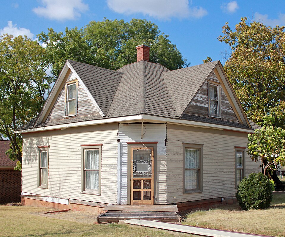
Listed on the National Register of Historic Places in 1984.
One of 11 National Register listings published here for Custer County · listed in 1984 · category: Building.
Sources: the case file at the National Archives · the National Register database, National Park Service
Regional context, not property-specific evidence. The federal wildfire occurrence database lists 39 fires within 5 miles of Crawford House between 1998 and 2020, burning about 534 acres in total. None started naturally. 2 were recorded as arson. Distance is straight-line from the map coordinates, so a fire counted here may appear on a neighbouring settlement's page as well.
| Reported cause | Fires |
|---|---|
| Missing data/not specified/undetermined | 14 |
| Fireworks | 7 |
| Equipment and vehicle use | 6 |
| Power generation/transmission/distribution | 3 |
| Railroad operations and maintenance | 3 |
| Debris and open burning | 2 |
| Smoking | 2 |
| Arson/incendiarism | 2 |
The most recent of them, most recent first, with the day each was reported and the service that recorded it.
| Date | Cause | Size | Reported by | Name on the report |
|---|---|---|---|---|
| 8 September 2000 | Debris and open burning | 32 acres | Concho Field Office | COLONY |
| 30 September 2005 | Missing data/not specified/undetermined | under an acre | Concho Field Office | CLINTON 2 |
| 13 September 2005 | Missing data/not specified/undetermined | under an acre | Concho Field Office | SNIDER |
| 24 August 2011 | Railroad operations and maintenance | 5.0 acres | Concho Field Office | TURTLE CREEK |
| 2 August 2006 | Equipment and vehicle use | 15 acres | Concho Field Office | JANCY |
| 5 July 2013 | Fireworks | 6.0 acres | Concho Field Office | FINALE |
| 5 July 2008 | Fireworks | under an acre | Concho Field Office | LUCKY STAR |
| 4 July 2001 | Arson/incendiarism | 1.0 acres | Concho Field Office | ORPHAN |
Regional context, not property-specific evidence. The federal mineral resources record lists 6 workings within 5 miles of Crawford House: 3 past producers, 3 producers. 3 still produce. What was taken out: Sand and Gravel, Construction, Clay. Distance is straight-line from the map coordinates, so a quarry counted here may appear on a neighbouring settlement's page as well.
| Where | Site | Commodity | Status | Recorded |
|---|---|---|---|---|
| Acme Brick Company Shale Pit | Clay | Producer | ||
| Acme Brick Company Shale Pit/Plant | Clay | Producer | ||
| Harold Pit | Sand and Gravel, Construction | Producer | ||
| Unknown Sand and Gravel Pit | Sand and Gravel, Construction | Past Producer | ||
| Unknown Sand and Gravel Pit | Sand and Gravel, Construction | Past Producer | ||
| Unknown Sand and Gravel Pit | Sand and Gravel, Construction | Past Producer |
Regional context, not property-specific evidence. The National Weather Service names Clinton, the town this property stands in, in 89 storm reports between 1994 and 2025: 42 thunderstorm wind, 34 hail, 6 flash flood, 4 tornado. No death or injury is recorded in these reports. Each account below is quoted exactly as the forecast office filed it, from the NOAA Storm Events Database, and each date opens the federal record of that event.
| When | Event | Place named | Harm | What the report says |
|---|---|---|---|---|
| June 2008 | Thunderstorm Wind | Clinton | $750,000 | Widespread damage occurred in and around Custer county. A Cessna 152 airplane was flipped, with the nose gear of two more collapsing in Clinton. Three vehicles were blown over on Interstate 40. One of the drivers was injured. Numerous barns were destroyed from Clinton to Custer City, with the contents of the barns also severely damaged. Several buildings sustained roof damage. Superior Well Services had its roof completely blown off and the bait shop at Foss Lake destroyed. Hundreds of power poles and trees were blown down around Custer county. The top of a large grain bin Sentinel Farmer's Co-Op was destroyed and another grain bin sustained severe damage. The loading arm which feeds grain from the bin to railroad cars broke. Over 90,000 bushels of wheat were destroyed as a result of the damage. Monetary damages were estimated. |
| May 1995 | Thunderstorm Wind | Clinton | $500,000 | no account filed |
| June 2005 | Thunderstorm Wind | Clinton | $300,000 | The strong winds damaged the roofs of several buildings and homes. One building was the United Grocery Store. The main roof damage was shingles blown off. Several carports were also blown over. Power lines were downed. A few semi-trucks were overturned on Interstate 40. |
| May 1997 | Thunderstorm Wind | Clinton | $80,000 | Severe thunderstorm winds caused widespread damage in and around Clinton. At the Clinton Airport an airplane was tossed 200 feet, one hangar was destroyed, and eight other hangars sustained heavy damage. Power was knocked out across much of the city. South of town two barns were severely damaged and a mobile home was blown over. On I-40 near Clinton six tractor-trailer trucks were blown over by the severe winds. |
| June 1994 | Thunderstorm Wind | Clinton | $50,000 | no account filed |
| May 2013 | Thunderstorm Wind | Clinton | $40,000 | A 60x30 ft. metal roof was blown off the Whitedog Hill Restaurant near I-40 mile marker 70. Billboard also damaged near the same location. |
| July 1998 | Thunderstorm Wind | Clinton | $34,000 | no account filed |
| May 2013 | Thunderstorm Wind | Clinton | $30,000 | Five power poles down 1 mile N of I-40 exit 71. |
| March 2000 | Thunderstorm Wind | Clinton | $25,000 | Numerous homes in the Westridge Addition received damage, while some barns were either damaged or destroyed. Two semis were also blown over on Interstate 40 just west of Clinton. |
| July 2023 | Thunderstorm Wind | Clinton | $20,000 | Top three-quarters of a communication tower broken and blown down. Time is radar estimated. |
| July 2023 | Thunderstorm Wind | Clinton | $20,000 | Report of power pole, power line and tree damage throughout the community of Clinton. This includes a portion of US Highway 183 blocked by downed power poles. Time is radar estimated. |
| July 2006 | Thunderstorm Wind | Clinton | $20,000 | Several large trees were uprooted on the south side of town. A home sustained some roof damage. An apartment roof was also heavily damaged. |
| May 2013 | Thunderstorm Wind | Clinton | $15,000 | Measured at KCSM. Moderate damage to airport. Doors were blown off a hangar, as well as windows in the control tower. A 400 lb. round bail was also blown into the ceilometer of the ASOS. |
| June 2007 | Thunderstorm Wind | Clinton | $15,000 | Four power poles and power lines were downed due to high wind. Monetary damages were estimated. |
| October 2021 | Thunderstorm Wind | Clinton | $10,000 | Roof and other structural damage reported with several building in and near Clinton. Time estimated by radar. |
| May 2019 | Flash Flood | Clinton | $10,000 | I-40 westbound near mile marker 66 has water across the road and cars stuck in median. |
| July 2015 | Flash Flood | Clinton | $10,000 | Cars stalled and several roads closed due to high water in Clinton. Time is estimated. |
| August 2021 | Thunderstorm Wind | Clinton | $5,000 | Power poles downed along Highway 183 north of county road east-west 1020. |
| May 2013 | Thunderstorm Wind | Clinton | $5,000 | Minor damage to a hangar at CLK airport. |
| June 1994 | Thunderstorm Wind | Clinton | $5,000 | no account filed |
| July 2017 | Thunderstorm Wind | Clinton | $2,000 | Structural damage near high school. Time estimated by radar and other reports. |
| May 2013 | Thunderstorm Wind | Clinton | $2,000 | Two trees of around 10 diameter were snapped. |
| June 2005 | Thunderstorm Wind | Clinton | $1,000 | Two to three inch diameter tree limbs were downed. |
| July 2002 | Thunderstorm Wind | Clinton | $1,000 | The top of a restaurant sign was blown off east of town. |
| July 2002 | Lightning | Clinton | $500 | Lightning struck a tree on Glenn Smith Road. |
| May 1996 | Lightning | Clinton | $200 | no account filed |
| June 2025 | Thunderstorm Wind | Clinton | - | Clinton Regional Airport (KCLK) observation. |
| June 2022 | Thunderstorm Wind | Clinton | - | Estimated severe wind gust. |
| June 2022 | Flash Flood | Clinton | - | Up to a foot of water in roadways and approaching homes. |
| October 2021 | Tornado (EFU) | Clinton | - | A number of storm chasers from various angles observed a second tornado adjacent to the tornado the moved from the east side of Clinton to southeast of Custer City. Although motion was difficult to determine at night, was believed to be a satellite tornado. This tornado produced no known damage and the location of this tornado was estimated. |
| October 2021 | Tornado (EF1) | Clinton | - | A tornado developed on the east side of Clinton near First Street and Route 66 (Business 40) where it damaged a automobile body shop and damaged a warehouse building. The tornado moved northeast across Riverside Golf Course where trees were damaged, then damaged and destroyed hangars at Clinton Municipal Airport (CLK). After the damage at the Clinton Municipal Airport, the tornado moved through more rural areas but did continue to damage trees, blow the roof off at least one outbuilding (with the debris blown to the northwest) and blew a street sign 200 yards. At one point, storm chasers observed a satellite tornado adjacent to this tornado (see separate entry). |
| October 2021 | Thunderstorm Wind | Clinton | - | Semi truck overturned along I40. |
| July 2019 | Flash Flood | Clinton | - | About 10 inches of water over the road on 10th street in Clinton. |
| May 2019 | Flash Flood | Clinton | - | Water flowing over I-40. |
| July 2014 | Thunderstorm Wind | Clinton | - | Measured at Clinton Regional Airport. |
| April 2012 | Thunderstorm Wind | Clinton | - | No damage occurred with the wind gust. |
| May 2010 | Tornado (EF1) | Clinton | - | Storm spotters observed a tornado that moved from Washita county into Custer county. The tornado damaged a barn and a residence, and downed a few power lines as it moved northeast across Interstate 40 east of Clinton. The tornado lifted north of Intestate 40 near Custer City Road. Monetary damages were not available. |
| September 2008 | Tornado (EF0) | Clinton | - | A brief tornado struck near the intersection of roads E1010 and N2270, to the northwest of Clinton Regional Airport. One utility pole was damaged. One residence was damaged and lost half of its roof, and the roof on a mobile home was damaged. One chicken coop was destroyed and all the livestock inside killed. Monetary damages were unavailable. |
| June 2007 | Thunderstorm Wind | Clinton | - | A storm chaser encountered winds estimated to be around 60 mph. |
| March 2004 | Hail | Clinton | - | Hail was reported on Highway 183. |
| April 2003 | Hail | Clinton | - | Hail was reported on Interstate 40. |
| June 1999 | Hail | Clinton | - | Hail was reported at exit 72 on Interstate 40. |
| August 1997 | Flash Flood | Clinton | - | Two intersections in town were closed due to flash flooding. |
| May 2025 | Hail | Clinton | - | no account filed |
| February 2023 | Thunderstorm Wind | Clinton | - | no account filed |
| February 2023 | Thunderstorm Wind | Clinton | - | no account filed |
| May 2022 | Thunderstorm Wind | Clinton | - | no account filed |
| June 2022 | Hail | Clinton | - | no account filed |
| March 2021 | Thunderstorm Wind | Clinton | - | no account filed |
| August 2021 | Thunderstorm Wind | Clinton | - | no account filed |
| August 2021 | Thunderstorm Wind | Clinton | - | no account filed |
| July 2020 | Thunderstorm Wind | Clinton | - | no account filed |
| November 2020 | Hail | Clinton | - | no account filed |
| February 2019 | Hail | Clinton | - | no account filed |
| May 2017 | Hail | Clinton | - | no account filed |
| May 2017 | Hail | Clinton | - | no account filed |
| June 2017 | Hail | Clinton | - | no account filed |
| June 2017 | Hail | Clinton | - | no account filed |
| June 2017 | Hail | Clinton | - | no account filed |
| May 2016 | Thunderstorm Wind | Clinton | - | no account filed |
No historic map-sheet match is published for this property yet. That does not mean no map exists. This record needs a coordinate-quality review before it can be joined to a sheet boundary. Browse the county's mapped places while that work is pending.
Other National Register properties close enough to walk or drive between, ordered by distance from this one. Both positions come from the same geocoding pass that matched these properties to their map sheets.
| Photograph | Property | Distance | Listed |
|---|---|---|---|
 | Clinton Armory | 0.9 miles | 1994 |
 | McLain Rogers Park | 1.0 miles | 2004 |
| Y Service Station and Cafe | 2.6 miles | 2004 |
| National Archives record | The nomination case file for reference 84002998 in Record Group 79. |
| Custer County | All 11 listed properties in this county. |