 Block
From the record
One of 6 National Register listings published here for Grant County · listed in 1984 · category: Building · built in 1910.
Sources: the case file at the National Archives · the National Register database, National Park Service
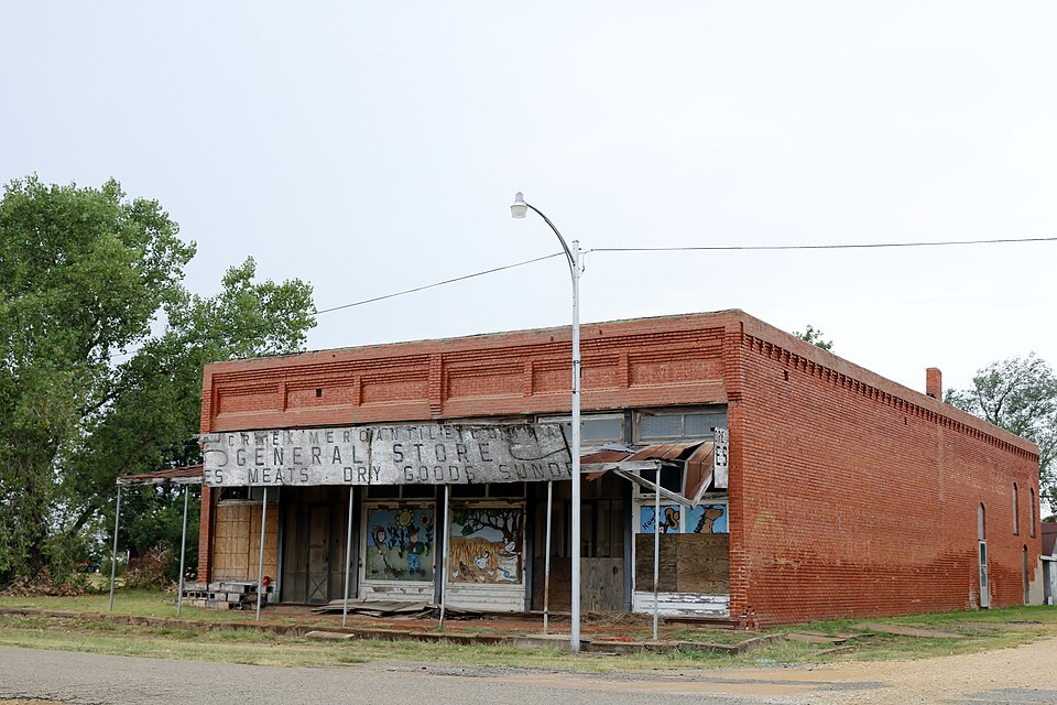
Built in 1910. Listed on the National Register of Historic Places in 1984.
One of 6 National Register listings published here for Grant County · listed in 1984 · category: Building · built in 1910.
Sources: the case file at the National Archives · the National Register database, National Park Service
Regional context, not property-specific evidence. The federal mineral resources record lists 4 workings within 5 miles of Deer Creek General Merchandise Store: 4 past producers. None of them still produces. What was taken out: Sand and Gravel, Construction, Clay. Distance is straight-line from the map coordinates, so a quarry counted here may appear on a neighbouring settlement's page as well.
| Where | Site | Commodity | Status | Recorded |
|---|---|---|---|---|
| Unknown Clay Pit | Clay | Past Producer | ||
| Unknown Sand Pit | Sand and Gravel, Construction | Past Producer | ||
| Unknown Sand Pit | Sand and Gravel, Construction | Past Producer | ||
| Unknown Sand Pits | Sand and Gravel, Construction | Past Producer |
Regional context, not property-specific evidence. The National Weather Service names Deer Creek, the town this property stands in, in 25 storm reports between 1994 and 2026: 15 hail, 5 tornado, 4 thunderstorm wind, 1 flood. No death or injury is recorded in these reports. Each account below is quoted exactly as the forecast office filed it, from the NOAA Storm Events Database, and each date opens the federal record of that event.
| When | Event | Place named | Harm | What the report says |
|---|---|---|---|---|
| July 2013 | Thunderstorm Wind | Deer Creek | $5,000 | Shingles were blown off roofs and numerous tree limbs downed. |
| June 2019 | Thunderstorm Wind | Deer Creek | $200 | Sheet metal outbuilding destroyed near Deer Creek. Time estimate from radar. |
| April 2026 | Hail | Deer Creek | - | An image from a broadcast media storm chaser was shared on social media. The location is approximate. |
| April 2026 | Tornado (EFU) | Deer Creek | - | Storm chasers with Oklahoma City television stations observed a tornado southeast of Renfrow and north of Deer Creek. No damage was reported and the path is estimated. |
| April 2024 | Hail | Deer Creek | - | MPing report. |
| April 2023 | Hail | Deer Creek | - | MPing report. |
| May 2019 | Thunderstorm Wind | Deer Creek | - | Estimated gusts. |
| May 2019 | Flood | Deer Creek | - | Standing water on roadway. Report with picture via twitter. |
| May 1997 | Hail | Deer Creek | - | at the intersection of Highways 11 and 74 |
| May 1997 | Tornado (F0) | Deer Creek | - | Brief touchdown reported by County Sheriff's Office |
| May 1997 | Tornado (F0) | Deer Creek | - | Second brief touchdown reported by County Sheriff's Office |
| November 2021 | Hail | Deer Creek | - | no account filed |
| May 2017 | Hail | Deer Creek | - | no account filed |
| July 2013 | Hail | Deer Creek | - | no account filed |
| April 2004 | Hail | Deer Creek | - | no account filed |
| July 2004 | Thunderstorm Wind | Deer Creek | - | no account filed |
| June 2004 | Hail | Deer Creek | - | no account filed |
| June 2004 | Hail | Deer Creek | - | no account filed |
| April 2003 | Hail | Deer Creek | - | no account filed |
| May 1998 | Hail | Deer Creek | - | no account filed |
| June 1997 | Hail | Deer Creek | - | no account filed |
| June 1996 | Hail | Deer Creek | - | no account filed |
| September 1996 | Tornado (F0) | Deer Creek | - | no account filed |
| September 1996 | Tornado (F0) | Deer Creek | - | no account filed |
| April 1994 | Hail | Deer Creek | - | no account filed |
No historic map-sheet match is published for this property yet. That does not mean no map exists. This record needs a coordinate-quality review before it can be joined to a sheet boundary. Browse the county's mapped places while that work is pending.
| National Archives record | The nomination case file for reference 84003024 in Record Group 79. |
| Grant County | All 6 listed properties in this county. |