 Block
From the record
One of 23 National Register listings published here for Osage County · listed in 1986 · category: District.
Sources: the case file at the National Archives · the National Register database, National Park Service
Listed on the National Register of Historic Places in 1986.
One of 23 National Register listings published here for Osage County · listed in 1986 · category: District.
Sources: the case file at the National Archives · the National Register database, National Park Service
Regional context, not property-specific evidence. The federal wildfire occurrence database lists 176 fires within 5 miles of Pawhuska Downtown Historic District between 2001 and 2020, burning about 12,831 acres in total. 10 started naturally. 53 were recorded as arson. Distance is straight-line from the map coordinates, so a fire counted here may appear on a neighbouring settlement's page as well.
| Reported cause | Fires |
|---|---|
| Debris and open burning | 54 |
| Arson/incendiarism | 53 |
| Power generation/transmission/distribution | 19 |
| Equipment and vehicle use | 18 |
| Missing data/not specified/undetermined | 16 |
| Natural | 10 |
| Misuse of fire by a minor | 2 |
| Fireworks | 2 |
| Other causes | 1 |
| Recreation and ceremony | 1 |
The most recent of them, most recent first, with the day each was reported and the service that recorded it.
| Date | Cause | Size | Reported by | Name on the report |
|---|---|---|---|---|
| 6 September 2017 | Debris and open burning | 1.0 acres | Osage Agency | BLAIR |
| 22 September 2002 | Power generation/transmission/distribution | 15 acres | Osage Agency | WOODSWF |
| 13 September 2013 | Debris and open burning | 58 acres | Osage Agency | MATTINGLY |
| 10 September 2012 | Equipment and vehicle use | 3.5 acres | Osage Agency | BLACK COW |
| 9 August 2008 | Other causes | under an acre | Osage Agency | LIVING GOD |
| 6 August 2006 | Equipment and vehicle use | 5.0 acres | Osage Agency | DONKEY |
| 31 August 2012 | Power generation/transmission/distribution | 3.3 acres | Osage Agency | BELLCO |
| 30 August 2012 | Arson/incendiarism | 1.0 acres | Osage Agency | CHIEF |
Regional context, not property-specific evidence. The federal mineral resources record lists 7 workings within 5 miles of Pawhuska Downtown Historic District: 4 past producers, 3 producers. 3 still produce. What was taken out: Stone, Crushed/Broken, Clay. Distance is straight-line from the map coordinates, so a quarry counted here may appear on a neighbouring settlement's page as well.
| Where | Site | Commodity | Status | Recorded |
|---|---|---|---|---|
| Unknown Shale Pit | Clay | Past Producer | ||
| Baker Stone Co Limestone Pit | Stone, Crushed/Broken | Producer | ||
| Baker Stone Co Limestone Pit | Stone, Crushed/Broken | Producer | ||
| Pawhuska Quarry & Mill | Stone, Crushed/Broken | Producer | ||
| Unknown Limestone Pit | Stone, Crushed/Broken | Past Producer | ||
| Unknown Limestone Pit | Stone, Crushed/Broken | Past Producer | ||
| Unknown Limestone Pit | Stone, Crushed/Broken | Past Producer |
Regional context, not property-specific evidence. The National Weather Service names Pawhuska, the town this property stands in, in 130 storm reports between 1993 and 2026: 73 hail, 46 thunderstorm wind, 6 flash flood, 5 tornado. The reports record 1 injury. Each account below is quoted exactly as the forecast office filed it, from the NOAA Storm Events Database, and each date opens the federal record of that event.
| When | Event | Place named | Harm | What the report says |
|---|---|---|---|---|
| August 1996 | Thunderstorm Wind | Pawhuska | 1 hurt, $8,000 | no account filed |
| May 1999 | Thunderstorm Wind | Pawhuska | $125,000 | Roofs were blown off houses, windows were knocked out of buildings, four trailers were turned over, porches were knocked off houses, and numerous trees were blown down. Some of the worst damage occurred in Indian Camp. |
| June 1997 | Thunderstorm Wind | Pawhuska | $125,000 | no account filed |
| April 2016 | Thunderstorm Wind | Pawhuska | $100,000 | Strong thunderstorm wind damaged an oil derrick, damaged several homes, uprooted trees, and blew down power poles west and northwest of Pawhuska. |
| May 2019 | Flash Flood | Pawhuska | $50,000 | Several streets were flooded in and around town, including Lynn Avenue that had about four feet of water flowing over it. A fire department was flooded. |
| May 2011 | Thunderstorm Wind | Pawhuska | $50,000 | Strong thunderstorm wind severely damaged a home and blew down large trees. |
| May 2008 | Hail | Pawhuska | $50,000 | no account filed |
| May 2017 | Hail | Pawhuska | $25,000 | no account filed |
| April 2016 | Hail | Pawhuska | $25,000 | no account filed |
| July 1999 | Thunderstorm Wind | Pawhuska | $20,000 | Winds damaged several boat docks at the second cove by Bluestem Lake. Trees were down along the shoreline. Roof damage and other damage were also evident. |
| May 2016 | Hail | Pawhuska | $20,000 | no account filed |
| May 2001 | Thunderstorm Wind | Pawhuska | $15,000 | Thunderstorm winds estimated at 70 miles an hour blew the roof off a house. |
| May 2000 | Flash Flood | Pawhuska | $12,000 | Heavy rains caused several roads in and around Pawhuska to be flooded. A few cars were stalled in the high water. |
| May 2011 | Thunderstorm Wind | Pawhuska | $10,000 | Strong thunderstorm wind blew down trees. |
| May 2017 | Hail | Pawhuska | $10,000 | no account filed |
| March 2016 | Hail | Pawhuska | $10,000 | no account filed |
| May 2008 | Tornado (EF0) | Pawhuska | $5,000 | A tornado damaged trees and blew down power lines. Several storm chasers observed this tornado. |
| May 2016 | Hail | Pawhuska | $5,000 | no account filed |
| April 2011 | Hail | Pawhuska | $5,000 | no account filed |
| March 2000 | Thunderstorm Wind | Pawhuska | $3,000 | Thunderstorm winds knocked down a transmission line linking several substations and created power outages in Pawhuska, Barnsdall, Shidler and Avant. |
| June 2025 | Thunderstorm Wind | Pawhuska | $2,000 | Strong thunderstorm wind damaged a roof, and blew down power lines. |
| September 1995 | Thunderstorm Wind | Pawhuska | $2,000 | ,,,,,,,,Hail (0.88) |
| May 2000 | Hail | Pawhuska | $1,000 | Golfball size hail fell at Osage Hills State Park damaging a camper. |
| May 1999 | Thunderstorm Wind | Pawhuska | $100 | Tree limbs were blown down in the Osage Hills State Park. |
| May 1996 | Thunderstorm Wind | Pawhuska | $100 | no account filed |
| May 2021 | Flash Flood | Pawhuska | - | Several roads were reported flooded on the east side of Pawhuska. |
| July 2020 | Thunderstorm Wind | Pawhuska | - | The RAWS site east of Pawhuska measured 58 mph thunderstorm wind gusts. |
| August 2020 | Thunderstorm Wind | Pawhuska | - | Strong thunderstorm wind snapped numerous large tree limbs. |
| June 2019 | Thunderstorm Wind | Pawhuska | - | Strong thunderstorm wind snapped large tree limbs. |
| August 2019 | Thunderstorm Wind | Pawhuska | - | Thunderstorm wind gusts to 60 mph were measured by storm chasers on east side of Pawhuska, near the Osage Casino. |
| August 2019 | Thunderstorm Wind | Pawhuska | - | Thunderstorm wind gusts to 60 mph were estimated east southeast of Pawhuska. |
| August 2019 | Thunderstorm Wind | Pawhuska | - | Thunderstorm wind gusts were measured to 62 mph. |
| May 2018 | Thunderstorm Wind | Pawhuska | - | Strong thunderstorm wind blew down trees. |
| May 2018 | Thunderstorm Wind | Pawhuska | - | Strong thunderstorm wind snapped large tree limbs. |
| June 2017 | Thunderstorm Wind | Pawhuska | - | Thunderstorm wind gusts were measured to 68 mph. |
| May 2013 | Thunderstorm Wind | Pawhuska | - | A tree was uprooted by strong thunderstorm wind. |
| April 2012 | Thunderstorm Wind | Pawhuska | - | Strong thunderstorm wind blew down large tree limbs. |
| April 2012 | Thunderstorm Wind | Pawhuska | - | Strong thunderstorm wind blew down large tree limbs. |
| May 2010 | Tornado (EF0) | Pawhuska | - | Several storm chasers reported a tornado over open country. |
| July 2009 | Thunderstorm Wind | Pawhuska | - | Thunderstorm winds estimated at 60 miles an hour blew down large tree limbs at Osage Hills State Park. |
| July 2009 | Thunderstorm Wind | Pawhuska | - | A trained spotter reported a 70 mile an hour wind gust from a thunderstorm. |
| June 2009 | Thunderstorm Wind | Pawhuska | - | A thunderstorm wind gust of 60 miles an hour was reported by amateur radio. |
| May 2008 | Tornado (EF0) | Pawhuska | - | A brief tornado developed over open country just north of town. This tornado was witnessed by several sources including a deputy with the Osage County Sheriff's Office. |
| June 2007 | Flash Flood | Pawhuska | - | Heavy thunderstorm rains caused flooding of rural roads across the northwestern part of Osage county. Highway 60 was also closed just north of Pawhuska. |
| July 2007 | Flash Flood | Pawhuska | - | Heavy rains caused flooding of roads just south of the Tall Grass Praire. |
| April 2007 | Tornado (EF0) | Pawhuska | - | A storm chaser for KOTV reported a tornado over open country. |
| June 2002 | Thunderstorm Wind | Pawhuska | - | Thunderstorm winds estimated at 60 miles an hour blew down large tree limbs. |
| May 2001 | Tornado (F0) | Pawhuska | - | A F0 tornado briefly touched down one mile south of Pawhuska. The tornado was video taped by a storm chaser. No damage was observed. |
| June 2001 | Thunderstorm Wind | Pawhuska | - | Thunderstorm winds estimated at 60 miles an hour blew down large tree limbs. |
| May 1998 | Thunderstorm Wind | Pawhuska | - | In addition, the Oklahoma mesonet site 2 S Wynona measured a wind gust of 51 miles an hour at 1145 PM CDT. |
| September 1995 | Hail | Pawhuska | - | ,,,,,,,,Hail (0.88) |
| September 1995 | Thunderstorm Wind | Pawhuska | - | ,,,,,,,,Hail (0.88) |
| July 1994 | Hail | Pawhuska | - | Severe thunderstorms developed in Osage County of northeast Oklahoma during the late afternoon and early evening of July 20th. Thunderstorm winds gusted to 60 to 70 mph at Pawhuska and Pershing, and quarter-size hail fell near Tallant. Nickel to quarter-size hail fell at Tallant, and dime-size hail fell at Pawhuska, 5 miles north of Pawhuska, and 5 miles west of Grainola. |
| July 1994 | Hail | Pawhuska | - | Severe thunderstorms developed in Osage County of northeast Oklahoma during the late afternoon and early evening of July 20th. Thunderstorm winds gusted to 60 to 70 mph at Pawhuska and Pershing, and quarter-size hail fell near Tallant. Nickel to quarter-size hail fell at Tallant, and dime-size hail fell at Pawhuska, 5 miles north of Pawhuska, and 5 miles west of Grainola. |
| July 1994 | Thunderstorm Wind | Pawhuska | - | Severe thunderstorms developed in Osage County of northeast Oklahoma during the late afternoon and early evening of July 20th. Thunderstorm winds gusted to 60 to 70 mph at Pawhuska and Pershing, and quarter-size hail fell near Tallant. Nickel to quarter-size hail fell at Tallant, and dime-size hail fell at Pawhuska, 5 miles north of Pawhuska, and 5 miles west of Grainola. |
| April 2026 | Hail | Pawhuska | - | no account filed |
| April 2026 | Hail | Pawhuska | - | no account filed |
| August 2024 | Hail | Pawhuska | - | no account filed |
| August 2019 | Hail | Pawhuska | - | no account filed |
| May 2017 | Hail | Pawhuska | - | no account filed |
No historic map-sheet match is published for this property yet. That does not mean no map exists. This record needs a coordinate-quality review before it can be joined to a sheet boundary. Browse the county's mapped places while that work is pending.
Other National Register properties close enough to walk or drive between, ordered by distance from this one. Both positions come from the same geocoding pass that matched these properties to their map sheets.
| Photograph | Property | Distance | Listed |
|---|---|---|---|
 | Osage County Courthouse | under 500 feet | 1984 |
 | Osage Agency | 0.1 miles | 1974 |
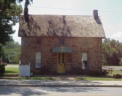 | Blacksmith's House | 0.1 miles | 1979 |
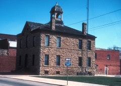 | City Hall | 0.1 miles | 1976 |
 | Pawhuska Armory | 0.8 miles | 1994 |
| National Archives record | The nomination case file for reference 86002355 in Record Group 79. |
| Osage County | All 23 listed properties in this county. |