 Block
From the record
One of 36 National Register listings published here for Garfield County · listed in 1987 · category: Building.
Sources: the case file at the National Archives · the National Register database, National Park Service
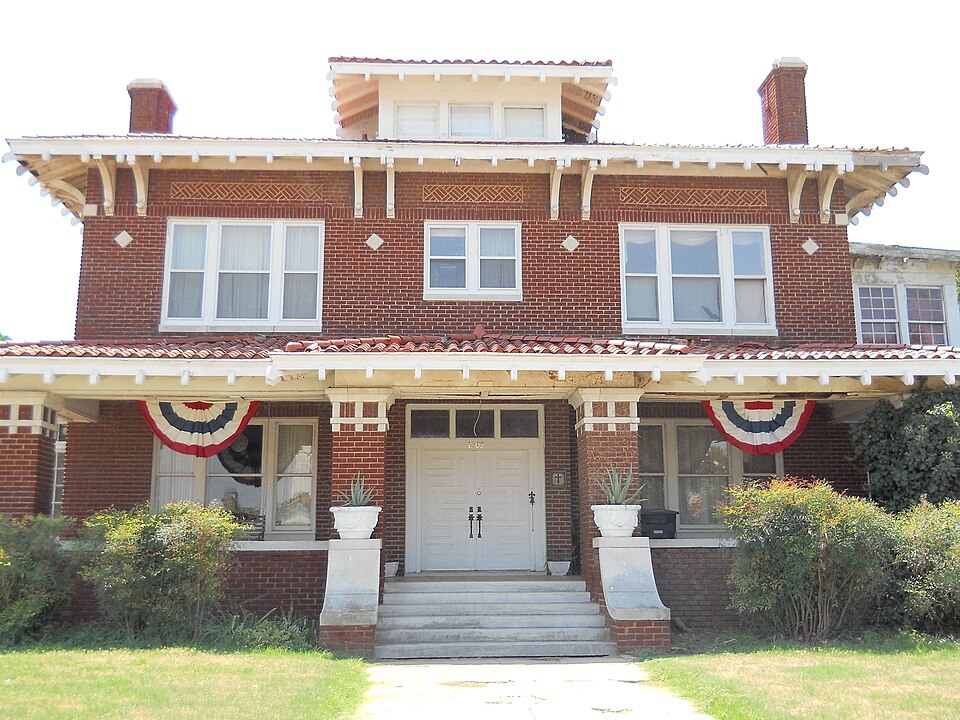
Listed on the National Register of Historic Places in 1987.
One of 36 National Register listings published here for Garfield County · listed in 1987 · category: Building.
Sources: the case file at the National Archives · the National Register database, National Park Service
Regional context, not property-specific evidence. The federal wildfire occurrence database lists 1 fire within 5 miles of T. T. Eason Mansion in 2001, burning about 200 acres in total. None started naturally. None was recorded as arson. Distance is straight-line from the map coordinates, so a fire counted here may appear on a neighbouring settlement's page as well.
| Reported cause | Fires |
|---|---|
| Missing data/not specified/undetermined | 1 |
The most recent of them, most recent first, with the day each was reported and the service that recorded it.
| Date | Cause | Size | Reported by | Name on the report |
|---|---|---|---|---|
| 3 April 2001 | Missing data/not specified/undetermined | 200 acres | Pawnee Agency | PAWNEE#1 |
Regional context, not property-specific evidence. The federal mineral resources record lists 9 workings within 5 miles of T. T. Eason Mansion: 6 past producers, 2 producers, 1 unknown. 2 still produce. What was taken out: Sand and Gravel, Construction, Clay. Distance is straight-line from the map coordinates, so a quarry counted here may appear on a neighbouring settlement's page as well.
| Where | Site | Commodity | Status | Recorded |
|---|---|---|---|---|
| Unknown Clay Pit | Clay | Producer | ||
| Benton Sand Co | Sand and Gravel, Construction | Unknown | ||
| Trexler Pit | Sand and Gravel, Construction | Producer | ||
| Unknown Sand Pit | Sand and Gravel, Construction | Past Producer | ||
| Unknown Sand Pit | Sand and Gravel, Construction | Past Producer | ||
| Unknown Sand Pit | Sand and Gravel, Construction | Past Producer | ||
| Unknown Sand Pit | Sand and Gravel, Construction | Past Producer | ||
| Unknown Sand Pit | Sand and Gravel, Construction | Past Producer | ||
| Unknown Sand Pits | Sand and Gravel, Construction | Past Producer |
Regional context, not property-specific evidence. The National Weather Service names Enid, the town this property stands in, in 203 storm reports between 1993 and 2026: 109 hail, 68 thunderstorm wind, 11 lightning, 11 flash flood. No death or injury is recorded in these reports. Each account below is quoted exactly as the forecast office filed it, from the NOAA Storm Events Database, and each date opens the federal record of that event.
| When | Event | Place named | Harm | What the report says |
|---|---|---|---|---|
| June 2007 | Thunderstorm Wind | Enid | $2,000,000 | The west facing windows at an auto dealership were blown out on the west side of town. Forty-five to fifty foot tall pine trees were uprooted. Some of the trees fell onto the roofs of some houses. Several roofs were destroyed, as well as several aluminum sheds destroyed. A total of more than one hundred homes sustained some kind of damage. The radio tower and roof at the KLGB radio station were blown down. Thirty windshields at Speed Tech Automotive & Truck Repair were shattered. |
| August 1993 | Thunderstorm Wind | Enid | $500,000 | An isolated thunderstorm during the afternoon hours on the 30th damaged bleachers and numerous signs and downed trees at the Garfield County Fairgrounds and at the Army Reserve Center in Enid. Damage was estimated at $50,000. |
| June 1994 | Thunderstorm Wind | Enid | $500,000 | no account filed |
| October 2005 | Lightning | Enid | $100,000 | Lightning struck the bell tower spire of St. Paul's Lutheran Church scattering debris up to 75 feet. Some children were in the basement, but no one was injured. |
| May 1999 | Lightning | Enid | $55,000 | no account filed |
| August 2025 | Thunderstorm Wind | Enid | $50,000 | Approximately twenty power poles were snapped between Wheatridge and Imo Roads. The location is approximate, and the event time is estimated from radar observations. |
| May 2013 | Thunderstorm Wind | Enid | $40,000 | Many trees and power lines downed, and a police officer was injured by debris. |
| March 2008 | Thunderstorm Wind | Enid | $25,000 | Several trees were knocked down near Oklahoma and Buchanan streets. One tree was blown onto a car. Six power poles were snapped west of Waukomis on Wood Road, closing the road for four hours. Monetary damages were estimated. |
| April 2004 | Thunderstorm Wind | Enid | $20,000 | Strong straight-line winds caused a mile wide swath of damage in the western business district of Enid along Highway 412, west of Highway 81. The roof was damaged at the Homeland grocery store and at Stevens Ford Dealership. Large metal power poles were also downed. |
| July 2004 | Thunderstorm Wind | Enid | $20,000 | Strong winds blew the roof off a pet hospital near the intersection of Van Buren and West Chestnut. |
| May 2020 | Thunderstorm Wind | Enid | $10,000 | Damage to power poles, fences, and tree limbs down in Enid. Time estimated by radar. |
| July 2020 | Thunderstorm Wind | North Enid | $10,000 | A tree fell on a house on the north side of Enid. |
| July 2011 | Thunderstorm Wind | North Enid | $10,000 | The wind gust was measured near the intersection of US-81 and Phillips Road. Numerous trees and fences were blown down. The roof of a roof was also blown off of a barn. Monetary damages were estimated. |
| June 2008 | Thunderstorm Wind | Enid | $10,000 | A couple of power lines were downed in the Enid area. Other power lines were reported downed in the Carrier and Hillsdale areas. Monetary damages were estimated. |
| October 2002 | Thunderstorm Wind | Enid | $10,000 | Two railroad cars were blown off the track. |
| May 1998 | Thunderstorm Wind | Enid | $10,000 | no account filed |
| October 1998 | Lightning | Enid | $6,000 | no account filed |
| August 2011 | Thunderstorm Wind | Enid | $5,000 | Power lines were downed at the intersection of Washington Street and Broadway Avenue. Monetary damages were estimated. |
| August 2011 | Thunderstorm Wind | Enid | $5,000 | Power lines were downed at the intersection of 1th Street and Randolph Avenue. Monetary damages were estimated. |
| May 2010 | Thunderstorm Wind | Enid | $5,000 | Several large tree limbs were downed, and a roof sustained minor roof damage. Monetary damages were estimated. |
| September 2007 | Flood | Enid | $5,000 | Four to seven inches of rain in a short period of time allowed for widespread flooding in Enid. Several water rescues were necessary after motorists drove into flood waters. Several roads in and around Enid were closed due to the rapidly rising water. Monetary damages were estimated. |
| March 2002 | Lightning | Enid | $5,000 | Lightning struck the roof of a Walmart causing slight damage. |
| July 1997 | Flash Flood | Enid | $5,000 | A major flash flood on Turkey Creek resulted in the flooding of a house and a nearby mobile home trailer and necessitated the swift-water rescue of a family of four from this flooded home. |
| May 1997 | Lightning | Enid | $5,000 | Lightning struck a three-story brick building on the Phillips Unversity Campus, damaging the front and the roof. |
| August 2010 | Thunderstorm Wind | Enid | $4,000 | Large power poles were downed near Garland Road and Highway 412. Monetary damages were estimated. |
| December 1999 | Lightning | Enid | $3,500 | no account filed |
| June 1999 | Lightning | Enid | $3,000 | no account filed |
| May 1999 | Lightning | Enid | $2,500 | no account filed |
| June 2018 | Thunderstorm Wind | Enid | $2,000 | Powerlines downed. |
| June 2010 | Thunderstorm Wind | Enid | $2,000 | Several tree limbs 4 inches in diameter and a power line were downed. Monetary damages were estimated. |
| June 2008 | Thunderstorm Wind | Enid | $2,000 | The severe winds downed a large tree on West Randolph Street. Monetary damages were estimated. |
| May 2000 | Thunderstorm Wind | Enid | $2,000 | A barn was partially damaged barn with debris from the barn blown onto Highway 81. |
| July 2000 | Thunderstorm Wind | Enid | $2,000 | Power poles were downed. |
| August 2010 | Thunderstorm Wind | Enid | $1,500 | Large tree limbs up to eight inches in diameter were downed, mainly across the western sides of Enid. Monetary damages were estimated. |
| June 2010 | Thunderstorm Wind | Enid | $1,000 | Several tree limbs up to six inches in diameter were downed by the strong winds. The downed limbs were reported a quarter of a mile southeast of downtown Enid. Monetary damages were estimated. |
| July 2000 | Thunderstorm Wind | Enid | $1,000 | Trees and power lines were downed. |
| September 1998 | Lightning | Enid | $1,000 | no account filed |
| August 2010 | Thunderstorm Wind | North Enid | $800 | A couple of highway signs were damaged and several large tree limbs were downed. Monetary damages were estimated. |
| June 1998 | Thunderstorm Wind | Enid | $500 | Severe thunderstorm winds wrapped a trampoline around a pole and downed many tree limbs. |
| September 1999 | Thunderstorm Wind | Enid | $500 | no account filed |
| April 1999 | Thunderstorm Wind | Enid | $500 | no account filed |
| November 1998 | Lightning | Enid | $200 | no account filed |
| April 2026 | Hail | North Enid | - | Hailfall near the intersection of U.S. Highway 81 and Oklahoma Highway 45. |
| April 2026 | Hail | Enid | - | The location is approximate. |
| April 2025 | Hail | Enid | - | Emergency management relayed multiple images. Event time is estimated from radar observations and additional nearby reports. |
| July 2025 | Hail | Enid | - | The location is approximate. |
| July 2025 | Thunderstorm Wind | Enid | - | A relayed image shows a large tree snapped in half. The location is approximate, and the event time is estimated from radar observations. |
| September 2025 | Hail | Enid | - | The location is approximate. |
| May 2024 | Hail | North Enid | - | MPing report. |
| May 2024 | Hail | Enid | - | MPing report. Time adjusted from radar and additional nearby reports. |
| May 2024 | Hail | Enid | - | Relayed image with ruler measurement. Time is radar estimated. |
| May 2024 | Hail | Enid | - | MPing report. |
| May 2024 | Flash Flood | Enid | - | Roadway flooding at the intersection of U.S. Highways 81 and 412. Event time is approximate. |
| May 2024 | Hail | Enid | - | MPing report. |
| May 2024 | Hail | Enid | - | MPing report. |
| May 2024 | Hail | Enid | - | Time is radar estimated and location is approximate. |
| May 2024 | Hail | North Enid | - | MPing report. Time adjusted from radar and additional nearby reports. |
| June 2023 | Thunderstorm Wind | North Enid | - | Social media image of 23-inch tree branches broken. |
| August 2023 | Thunderstorm Wind | North Enid | - | Personal weather station measurement. Time is estimated. |
| July 2021 | Flash Flood | North Enid | - | Six water rescues within Enid. 8 to 10 feet of water below one underpass. |
No historic map-sheet match is published for this property yet. That does not mean no map exists. This record needs a coordinate-quality review before it can be joined to a sheet boundary. Browse the county's mapped places while that work is pending.
Other National Register properties close enough to walk or drive between, ordered by distance from this one. Both positions come from the same geocoding pass that matched these properties to their map sheets.
| Photograph | Property | Distance | Listed |
|---|---|---|---|
 | McCristy-Knox Mansion | under 500 feet | 1987 |
 | Waverley Historic District | under 500 feet | 2006 |
| H. L. Kaufman House | 0.3 miles | 1985 | |
 | H. H. Champlin House | 0.4 miles | 1993 |
| Liberty Federal Savings and Loan Association Building | 0.6 miles | 2021 | |
 | Lamerton House | 0.7 miles | 1997 |
| National Archives record | The nomination case file for reference 87000417 in Record Group 79. |
| Garfield County | All 36 listed properties in this county. |