 Block
From the record
One of 10 National Register listings published here for Hughes County · listed in 1988 · category: Building · built in 1936.
Sources: the case file at the National Archives · the National Register database, National Park Service
Built in 1936. Listed on the National Register of Historic Places in 1988.
One of 10 National Register listings published here for Hughes County · listed in 1988 · category: Building · built in 1936.
Sources: the case file at the National Archives · the National Register database, National Park Service
Regional context, not property-specific evidence. The federal wildfire occurrence database lists 24 fires within 5 miles of Spaulding School Gymnasium-Auditorium between 1996 and 2020, burning about 1,072 acres in total. 1 started naturally. 7 were recorded as arson. Distance is straight-line from the map coordinates, so a fire counted here may appear on a neighbouring settlement's page as well.
| Reported cause | Fires |
|---|---|
| Arson/incendiarism | 7 |
| Missing data/not specified/undetermined | 7 |
| Debris and open burning | 6 |
| Power generation/transmission/distribution | 2 |
| Railroad operations and maintenance | 1 |
| Natural | 1 |
The most recent of them, most recent first, with the day each was reported and the service that recorded it.
| Date | Cause | Size | Reported by | Name on the report |
|---|---|---|---|---|
| 2 August 2008 | Power generation/transmission/distribution | 2.7 acres | Wewoka Agency | CHILLY FISH |
| 29 March 2010 | Debris and open burning | 1.6 acres | Okmulgee Field Office | WOODS |
| 2 March 2007 | Arson/incendiarism | 4.1 acres | Wewoka Agency | ROCKIN M |
| 15 March 2019 | Arson/incendiarism | 2.0 acres | Okmulgee Field Office | KEYSTONE |
| 8 February 2016 | Missing data/not specified/undetermined | 420 acres | Okmulgee Field Office | GREENLEAF |
| 23 February 1996 | Arson/incendiarism | 285 acres | Chickasaw Agency | CANDICE |
| 22 February 2007 | Missing data/not specified/undetermined | under an acre | Wewoka Agency | CHIEF |
| 20 February 2014 | Power generation/transmission/distribution | 1.7 acres | Wewoka Agency | PIT BULL |
Regional context, not property-specific evidence. The federal mineral resources record lists 2 workings within 5 miles of Spaulding School Gymnasium-Auditorium: 2 past producers. None of them still produces. What was taken out: Sand and Gravel, Construction. Distance is straight-line from the map coordinates, so a quarry counted here may appear on a neighbouring settlement's page as well.
| Where | Site | Commodity | Status | Recorded |
|---|---|---|---|---|
| Unknown Gravel Pit | Sand and Gravel, Construction | Past Producer | ||
| Unknown Sand Pit | Sand and Gravel, Construction | Past Producer |
Regional context, not property-specific evidence. The National Weather Service names Spaulding, the town this property stands in, in 3 storm reports between 2011 and 2025: 2 tornado, 1 hail. The reports record 3 deaths and 5 injuries. Each account below is quoted exactly as the forecast office filed it, from the NOAA Storm Events Database, and each date opens the federal record of that event.
| When | Event | Place named | Harm | What the report says |
|---|---|---|---|---|
| April 2024 | Tornado (EF3) | Spaulding | 2 killed, 4 hurt, $1,500,000 | The Spaulding-Holdenville Tornado developed along County Road N369 in the south side of the town of Spaulding and moved north through Spaulding causing roof damage to a few homes and damaging some outbuildings, metal buildings and trees. The damage in and near Spaulding was primarily EF1 damage.||The tornado became wider as it moved north-northeast from Spaulding becoming almost two-thirds of a mile wide as it crossed County Road E135 and a mile wide as it moved north of County Road E134. Most of the damage west of Holdenville was between Spaulding Road and County Road N369 missing the most populated part of Holdenville to the west and the missing the Davis Correctional Facility to the east. The tornado continued producing roof damage to homes as well as damage to outbuildings, metal buildings, trees and power poles. ||The tornado was still about one mile in width as it moved north-northeast crossing US Highway 270 and County Road E132, but the intensity increased from EF1 to EF3 as it approached County Road E131. Multiple mobile homes were completely destroyed in this area. Two fatalities occurred in mobile homes here where a 35 year old man was killed in one mobile home and a 4 month old girl was killed in another.||Although the tornado moved through less densely populated areas of Hughes County continued moving north-northeast through less densely populated areas of Hughes County, it still produced significant roof damage to homes and destroyed mobile homes as it continued moving north-northeast, especially along State Highway 48 north of Holdenville, County Road E125 just east of State Highway 48, and E120 Road where EF2 damage was observed in each of these areas. The tornado then crossed E119 Road into Okfuskee County. See the Eastern Oklahoma entry from NWS Tulsa for the continuation of this tornado. |
| April 2025 | Tornado (EF1) | Spaulding | 1 killed, 1 hurt, $400,000 | Tornado began south of Spaulding, moving to the north into Spaulding and then northeast. EF1 damage was found in Spaulding at a manufactured home which suffered major damage along E138 Road where one man was killed and a woman injured. Several homes had at least minor damage, with several homes losing roofs, windows, and walls. |
| April 2011 | Hail | Spaulding | - | no account filed |
No historic map-sheet match is published for this property yet. That does not mean no map exists. This record needs a coordinate-quality review before it can be joined to a sheet boundary. Browse the county's mapped places while that work is pending.
Other National Register properties close enough to walk or drive between, ordered by distance from this one. Both positions come from the same geocoding pass that matched these properties to their map sheets.
| Photograph | Property | Distance | Listed |
|---|---|---|---|
 | Holdenville City Hall | 5.5 miles | 1981 |
| John E. Turner House | 5.6 miles | 1983 | |
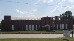 | Holdenville Armory | 6.1 miles | 1988 |
| National Archives record | The nomination case file for reference 88001389 in Record Group 79. |
| Hughes County | All 10 listed properties in this county. |