 Block
From the record
One of 6 National Register listings published here for Greer County · listed in 1994 · category: Building.
Sources: the case file at the National Archives · the National Register database, National Park Service
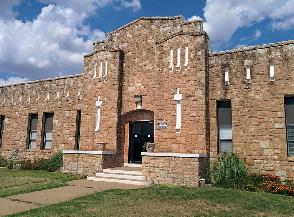
Listed on the National Register of Historic Places in 1994.
One of 6 National Register listings published here for Greer County · listed in 1994 · category: Building.
Sources: the case file at the National Archives · the National Register database, National Park Service
Regional context, not property-specific evidence. The federal mineral resources record lists 4 workings within 5 miles of Mangum Armory: 3 past producers, 1 producer. 1 still produces. What was taken out: Sand and Gravel, Construction, Clay. Distance is straight-line from the map coordinates, so a quarry counted here may appear on a neighbouring settlement's page as well.
| Where | Site | Commodity | Status | Recorded |
|---|---|---|---|---|
| Mangum Mine and Mill (unverified) | Clay | Producer | ||
| Unknown Gravel Pit | Sand and Gravel, Construction | Past Producer | ||
| Unknown Gravel Pit | Sand and Gravel, Construction | Past Producer | ||
| Unknown Gravel Pit | Sand and Gravel, Construction | Past Producer |
Regional context, not property-specific evidence. The National Weather Service names Mangum, the town this property stands in, in 168 storm reports between 1993 and 2026: 108 hail, 46 thunderstorm wind, 6 flash flood, 4 tornado. No death or injury is recorded in these reports. Each account below is quoted exactly as the forecast office filed it, from the NOAA Storm Events Database, and each date opens the federal record of that event.
| When | Event | Place named | Harm | What the report says |
|---|---|---|---|---|
| August 1994 | Thunderstorm Wind | Mangum | $500,000 | no account filed |
| April 2025 | Hail | Mangum | $150,000 | Numerous social media and broadcast media images of at least 3-inch diameter hail in Mangum. Widespread damage to buildings and cars was reported. Event time is estimated from radar observations and nearby reports. |
| August 1997 | Lightning | Mangum | $100,000 | Lightning struck and set fire to a house, destroying the home and its contents. |
| October 2018 | Flash Flood | Mangum | $75,000 | Flood waters have resulted in closure of several streets and flooding into homes. |
| June 1996 | Thunderstorm Wind | Mangum | $50,000 | no account filed |
| August 1994 | Thunderstorm Wind | Mangum | $50,000 | no account filed |
| September 2002 | Thunderstorm Wind | Mangum | $30,000 | A roof of a restaurant was damaged. Trees were downed. Windows were broken, and carports were blown off of two homes. |
| August 2004 | Thunderstorm Wind | Mangum | $25,000 | Winds destroyed a trailer on the southwest side of town. |
| March 2000 | Thunderstorm Wind | Mangum | $25,000 | Four barns and a trailer were blown over. |
| August 2003 | Thunderstorm Wind | Mangum | $12,000 | Large tree limbs were downed. Large portions of two fences were also downed. One home received extensive shingle damage to its roof. A steel flag pole was also snapped. The wind damage began in northern parts of town and continued south. |
| July 2003 | Thunderstorm Wind | Mangum | $10,000 | Several tree limbs and power poles were downed across the town. Sheet metal was also peeled from several carports. |
| June 2006 | Thunderstorm Wind | Mangum | $7,500 | A patio cover was blown apart. Several small trees were also downed. |
| July 2001 | Thunderstorm Wind | Mangum | $5,000 | A large metal barn was destroyed. |
| June 1994 | Thunderstorm Wind | Mangum | $5,000 | no account filed |
| May 1999 | Thunderstorm Wind | Mangum | $3,000 | no account filed |
| July 2003 | Hail | Mangum | $2,500 | Hail damaged a screen door and broke windows in a few businesses. |
| April 2003 | Thunderstorm Wind | Mangum | $2,000 | Power lines were downed. |
| June 2006 | Thunderstorm Wind | Mangum | $500 | Some tree limbs were downed. |
| July 2001 | Thunderstorm Wind | Mangum | $500 | Highway signs were blown down. |
| April 1999 | Thunderstorm Wind | Mangum | $100 | no account filed |
| March 2000 | Thunderstorm Wind | Mangum | $10 | Large tree limbs were downed on the southeast side of Mangum. |
| April 2026 | Hail | Mangum | - | The report was relayed through mPING. |
| March 2025 | Hail | Mangum | - | MPing report. |
| April 2025 | Hail | Mangum | - | The report was relayed through mPING. |
| June 2025 | Hail | Mangum | - | The report was relayed through mPING. |
| March 2024 | Hail | Mangum | - | MPing report. |
| June 2023 | Hail | Mangum | - | MPing report. |
| June 2021 | Flood | Mangum | - | Creek overflowing. |
| June 2021 | Flash Flood | Mangum | - | Highway 9 just west of Mangum completely flooded. |
| June 2021 | Flash Flood | Mangum | - | Flooded streets and neighborhoods seen on Twitter video. |
| June 2021 | Thunderstorm Wind | Mangum | - | Large trees downed. |
| May 2020 | Thunderstorm Wind | Mangum | - | Also pea sized hail reported. |
| May 2012 | Hail | Mangum | - | Numerous hailstones covered the ground. |
| June 2011 | Hail | Mangum | - | A wind gust of 60 mph was also estimated at this location. |
| June 2011 | Thunderstorm Wind | Mangum | - | Quarter-size hail also fell at this location. |
| June 2011 | Hail | Mangum | - | Up to quarter-size hail lasted about 12 minutes. |
| June 2009 | Thunderstorm Wind | Mangum | - | Damage was reported at the softball field, including a fence blown down, the dugout shelter flipped over, and power poles damaged. Monetary damage estimates were not available. |
| April 2007 | Hail | Mangum | - | Hail covered the ground. |
| April 2006 | Tornado (F0) | Mangum | - | A brief tornado was seen by several storm chasers and a television crew. This tornado touched down north of Mangum, near Highway 283. No damage was reported. |
| August 2006 | Thunderstorm Wind | Mangum | - | Wind was measured by the Oklahoma mesonet. |
| May 2005 | Hail | Mangum | - | Hail was observed on Highway 34 on the south side of town. |
| August 2005 | Thunderstorm Wind | Mangum | - | The wind was measured by the Oklahoma mesonet. |
| September 2005 | Thunderstorm Wind | Mangum | - | Wind was measured by the Oklahoma mesonet. |
| September 2005 | Hail | Mangum | - | Hail was observed on Highway 34. |
| September 2005 | Hail | Mangum | - | Hail was reported on the south side of town. |
| September 2005 | Hail | Mangum | - | Hail was reported on the east side of town. |
| May 2004 | Hail | Mangum | - | Hail was reported on the west side of town. |
| April 2003 | Thunderstorm Wind | Mangum | - | Wind was measured by the Oklahoma mesonet. |
| June 2002 | Thunderstorm Wind | Mangum | - | Wind was measured by the Oklahoma mesonet. |
| June 2002 | Thunderstorm Wind | Mangum | - | Wind was measured by the Oklahoma mesonet. |
| June 2002 | Thunderstorm Wind | Mangum | - | Wind was measured by the Oklahoma mesonet. |
| May 2001 | Hail | Mangum | - | Hail was reported on the north side of Mangum. |
| May 2000 | Hail | Mangum | - | Hail was reported at the intersection of Highway 9 and Highway 283. |
| May 2000 | Funnel Cloud | Mangum | - | A funnel cloud extending about 1/4 of the way to the ground dissipated in 1 minute. |
| June 1998 | Hail | Mangum | - | Golfball sized hail was reported by spotter on the Greer and Jackson County line. |
| July 1997 | Thunderstorm Wind | Mangum | - | measured at the Oklahoma Mesonet site |
| August 1997 | Flash Flood | Mangum | - | The intersection of US Hwy 283 and State Hwy 9 was flooded and closed. |
| May 2025 | Hail | Mangum | - | no account filed |
| February 2023 | Hail | Mangum | - | no account filed |
| March 2021 | Hail | Mangum | - | no account filed |
No historic map-sheet match is published for this property yet. That does not mean no map exists. This record needs a coordinate-quality review before it can be joined to a sheet boundary. Browse the county's mapped places while that work is pending.
Other National Register properties close enough to walk or drive between, ordered by distance from this one. Both positions come from the same geocoding pass that matched these properties to their map sheets.
| Photograph | Property | Distance | Listed |
|---|---|---|---|
 | Greer County Courthouse | 0.1 miles | 1985 |
| Downtown Mangum Historic District | 0.1 miles | 2009 | |
 | Mangum Community Building | 0.2 miles | 1995 |
 | Hotel Franklin | 0.2 miles | 2007 |
| National Archives record | The nomination case file for reference 94000278 in Record Group 79. |
| Greer County | All 6 listed properties in this county. |