 Block
From the record
One of 6 National Register listings published here for Murray County · listed in 1994 · category: Building · built in 1908.
Sources: the case file at the National Archives · the National Register database, National Park Service
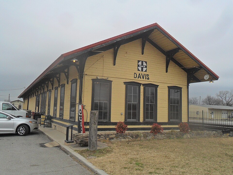
Built in 1908. Listed on the National Register of Historic Places in 1994.
One of 6 National Register listings published here for Murray County · listed in 1994 · category: Building · built in 1908.
Sources: the case file at the National Archives · the National Register database, National Park Service
Regional context, not property-specific evidence. The federal wildfire occurrence database lists 22 fires within 5 miles of Davis Santa Fe Depot between 1992 and 2020, burning about 7,226 acres in total. 2 started naturally. 4 were recorded as arson. Distance is straight-line from the map coordinates, so a fire counted here may appear on a neighbouring settlement's page as well.
| Reported cause | Fires |
|---|---|
| Missing data/not specified/undetermined | 8 |
| Debris and open burning | 5 |
| Arson/incendiarism | 4 |
| Natural | 2 |
| Power generation/transmission/distribution | 2 |
| Equipment and vehicle use | 1 |
The most recent of them, most recent first, with the day each was reported and the service that recorded it.
| Date | Cause | Size | Reported by | Name on the report |
|---|---|---|---|---|
| 5 September 1995 | Missing data/not specified/undetermined | 8.5 acres | Chickasaw National Recreation Area | WESTHUNT |
| 29 August 2011 | Missing data/not specified/undetermined | 7.0 acres | Chickasaw National Recreation Area | LEE |
| 2 August 2011 | Missing data/not specified/undetermined | 4.0 acres | Chickasaw National Recreation Area | SHEPARD HILL |
| 17 August 2006 | Arson/incendiarism | 1,423 acres | Chickasaw Agency | TURNER FALLS #3 |
| 14 July 2011 | Equipment and vehicle use | 8.8 acres | Chickasaw Agency | HOTTLE FIRE |
| 13 July 2011 | Natural | 22 acres | Chickasaw Agency | SUB STATION |
| 9 April 2009 | Missing data/not specified/undetermined | 3,000 acres | Chickasaw National Recreation Area | DOLESE |
| 11 April 2003 | Debris and open burning | 600 acres | Chickasaw Agency | MUSTANG |
Regional context, not property-specific evidence. The federal mineral resources record lists 14 workings within 5 miles of Davis Santa Fe Depot: 12 past producers, 2 producers. 2 still produce. What was taken out: Stone, Crushed/Broken, Sand and Gravel, Construction. Distance is straight-line from the map coordinates, so a quarry counted here may appear on a neighbouring settlement's page as well.
| Where | Site | Commodity | Status | Recorded |
|---|---|---|---|---|
| Unknown Gravel Pit | Sand and Gravel, Construction | Past Producer | ||
| Unknown Gravel Pit | Sand and Gravel, Construction | Past Producer | ||
| Unknown Gravel Pit | Sand and Gravel, Construction | Past Producer | ||
| Unknown Gravel Pit | Sand and Gravel, Construction | Past Producer | ||
| Unknown Sand Pit | Sand and Gravel, Construction | Past Producer | ||
| Unknown Sand Pit | Sand and Gravel, Construction | Producer | ||
| Davis Pit and Plant | Stone, Crushed/Broken | Producer | ||
| Sooner Rock & Sand Co Limestone Pit | Stone, Crushed/Broken | Past Producer | ||
| Unknown Limestone Pit | Stone, Crushed/Broken | Past Producer | ||
| Unknown Limestone Pit | Stone, Crushed/Broken | Past Producer |
Regional context, not property-specific evidence. The National Weather Service names Davis, the town this property stands in, in 110 storm reports between 1993 and 2026: 51 hail, 35 thunderstorm wind, 19 flash flood, 3 tornado. No death or injury is recorded in these reports. Each account below is quoted exactly as the forecast office filed it, from the NOAA Storm Events Database, and each date opens the federal record of that event.
| When | Event | Place named | Harm | What the report says |
|---|---|---|---|---|
| May 1995 | Tornado (F1) | Davis | $500,000 | no account filed |
| May 2001 | Thunderstorm Wind | Davis | $200,000 | The roof of City Hall was blown off with rain falling inside the building. Several road signs were blown over, and additional roof damage was reported across the city. |
| March 2004 | Thunderstorm Wind | Davis | $80,000 | A barn roof was blown off. A metal barn was also destroyed along with power lines downed. |
| March 2004 | Thunderstorm Wind | Davis | $65,000 | The city barn and a few lumber barns were destroyed. A light pole was also broken. Several signs were damaged across town. |
| September 1999 | Thunderstorm Wind | Davis | $25,000 | no account filed |
| April 2016 | Thunderstorm Wind | Davis | $20,000 | The most significant damage occurred to a church in the central part of Davis, but significant scattered tree damage was also noted across town. Additional damage was photographed by a Facebook user, including a trailer and several sheds that were damaged or destroyed. |
| May 2009 | Thunderstorm Wind | Davis | $15,000 | Several large tree limbs and power lines were downed due to the wind, causing widespread power outages. Monetary damages were estimated. |
| August 2002 | Thunderstorm Wind | Davis | $15,000 | A trailer home was unroofed, and trees were downed. |
| January 2000 | Lightning | Davis | $15,000 | Lightning struck a house on S. Fourth St. causing a fire that resulted in major damage to the attic and master bedroom. |
| May 2011 | Thunderstorm Wind | Davis | $11,000 | A roof was taken off of a large metal shop building, with overhead doors on the east and west sides. Pieces of the roof landed on Highway 7, with local authorities having to briefly reroute traffic. The building was located near US Highway 7 and State Highway 110. No injuries were reported. Monetary damages were estimated. |
| August 2005 | Flash Flood | Davis | $10,000 | Rainfall totals of 4 to 8+ inches over the Arbuckle Mountains in Murray County in south central Oklahoma during the overnight hours of August 14-15 triggered heavy runoff and flash flooding in Turner Falls Park. The flash flooding washed away beaches at Turner Falls, and eroded the bank near a building just downstream of the waterfall. Some campers were forced to evacuate from the park, while other campers became stranded when a low water crossing across Honey Creek, downstream of Turner Falls and 4 miles south of Davis, OK, became impassible during the morning of August 15.A USGS river gage station located near the low water crossing recorded a significant rise for Honey Creek during the event. The 4-8 inch rainfall totals on August 14-15 produced a flood crest 3.5 feet higher than the low water crossing elevation. Low stages at the site are usually around 1.4 feet, but a crest of 4.9 feet occurred at 4:00 am CST on August 15.The flash flooding deposited brush and debris along the Honey Creek, and 150 tons of sand were delivered to the area to rebuild washed-away beaches., The City of Davis, which owns the park, was forced to close it for about a week while repairs were made. |
| July 2000 | Thunderstorm Wind | Davis | $10,000 | A tractor-trailer was blown over, while traveling westbound on State Highway 7. |
| September 1999 | Thunderstorm Wind | Davis | $7,000 | no account filed |
| April 2026 | Thunderstorm Wind | Davis | $5,000 | Tree limbs were blown down and fences were damaged. The location is approximate, and the event time is estimated based on radar observations. |
| August 2010 | Thunderstorm Wind | Davis | $5,000 | Power lines were downed throughout town. Monetary damages were estimated. |
| June 2009 | Thunderstorm Wind | Davis | $5,000 | Six- to seven-inch diameter tree limbs were blown down. Monetary damages were estimated. |
| February 1999 | Thunderstorm Wind | Davis | $5,000 | no account filed |
| July 1995 | Thunderstorm Wind | Davis | $5,000 | no account filed |
| May 2017 | Flash Flood | Davis | $2,000 | Roadways were flooded. Water made it into the basement of an elementary school. |
| August 2001 | Thunderstorm Wind | Davis | $2,000 | Trees and power poles were downed. |
| July 2005 | Thunderstorm Wind | Davis | $500 | Tree limbs, three inches in diameter, were downed. |
| November 1998 | Thunderstorm Wind | Davis | $500 | no account filed |
| November 1998 | Thunderstorm Wind | Davis | $500 | no account filed |
| June 1998 | Thunderstorm Wind | Davis | $10 | Severe thunderstorm winds up to 60 mph downed tree limbs up to 5 inches in diameter. |
| March 2026 | Thunderstorm Wind | Davis | - | Multiple trees were blown down in Davis, with some blocking area roadways. The event time is estimated based on radar observations. |
| April 2026 | Hail | Davis | - | The report was relayed through mPING. The event time was adjusted based on radar observations. |
| April 2026 | Hail | Davis | - | The location is approximate. |
| March 2024 | Hail | Davis | - | MPing report. |
| March 2024 | Hail | Davis | - | MPing report. |
| July 2020 | Thunderstorm Wind | Davis | - | Power pole and powerline damage reported on Hwy 77. |
| June 2019 | Thunderstorm Wind | Davis | - | Power line downed. |
| September 2018 | Flash Flood | Davis | - | Water was up to the foundation of several homes in Davis. |
| September 2018 | Flash Flood | Davis | - | Highway 77 south of Davis to I-35 has been shutdown by ODOT. |
| June 2018 | Flash Flood | Davis | - | High water reported over highway 77. |
| October 2018 | Tornado (EF0) | Davis | - | Numerous storm chasers and storm spotters observed a relatively weak tornado that formed just east of Interstate 35 west of Davis. The tornado moved northeast crossing State Highway 7 into Garvin County near NS328 Road. Other than some tree limb damage, no other damage was reported. |
| May 2017 | Flash Flood | Davis | - | Highway 77 near McLec Industrial Drive south of Davis was flooded with 6 to 8 inches water across the entire road. |
| May 2017 | Thunderstorm Wind | Davis | - | No damage reported. |
| August 2016 | Thunderstorm Wind | Davis | - | No damage was reported. |
| June 2015 | Flash Flood | Davis | - | Multiple roads closed around Davis. One to two feet of water across roadways. |
| June 2015 | Flood | Davis | - | Roadways flooded with several inches of water. |
| July 2015 | Flash Flood | Davis | - | Streets in town were closed due to flooding. |
| May 2015 | Flash Flood | Davis | - | Street flooding in and around Davis. |
| August 2013 | Flash Flood | Davis | - | County road 7 between Sulphur and Davis closed due to rushing water over roadway. |
| April 2011 | Hail | Davis | - | The hail was reported on the northern side of town. |
| November 2011 | Flash Flood | Davis | - | A culvert was washed out on Hanover Street between Cherry Road and Highway 7. |
| May 2011 | Hail | Davis | - | The hail was reported on Exit 55 of Interstate 35. |
| May 2010 | Hail | Davis | - | The report was relayed by the NWS Amarillo. |
| May 2009 | Flash Flood | Davis | - | Many secondary roads between Davis an Dougherty were closed due to water running over top of them. |
| May 2009 | Thunderstorm Wind | Davis | - | The wind gust was measured at mile marker 55 on Interstate 35. |
| July 2009 | Thunderstorm Wind | Davis | - | The wind gust was relayed by the Murray County Sheriff. |
| March 2007 | Flash Flood | Davis | - | Rainfall totals of 2 to 3 inches over Murray County during the afternoon of March 30 produced flash flooding in the area. At 1955 CST, the public reported flash flooding 4 miles south of the city of Davis in Turner Falls Park. In addition, the USGS river gage along Honey Creek at the low water crossing near the entrance of Turner Falls Park crested at a stage of 4.6 feet during the evening of March 30. The floodwaters on Honey Creek reached a depth of more than 3 feet over the roadway, and park officials were forced to close the crossing. A small creek in the Camp Classen area also rose to several feet over a low water crossing on a local road near the main entrance of the camp, prompting camp officials to close the road. |
| August 2005 | Flash Flood | Davis | - | Additional rainfall and runoff during the morning hours of August 16 in Murray County generated another crest on Honey Creek in Turner Falls Park, 4 miles south of Davis, OK. A crest of 2.9 feet at 3:30 pm CST on August 16 made a low water crossing near the park entrance impassible for a few hours during the afternoon. |
| July 2004 | Flash Flood | Davis | - | During the late evening and early morning of July 28-29, multiple rounds of thunderstorms produced rainfall totals of 3 to 6 inches over parts of Murray county in south central Oklahoma. The heavy rainfall produced flash flooding and nuisance flooding in several places, including in the Arbuckle Mountains in Turner Falls Park near Davis, OK. Up to 6 inches of rain fell in the area, and Turner Falls Park was closed for at approximately 24 hours beginning at 2:00 am CST on July 29 as water levels in some streams and creeks including Honey Creek were raised 1 to 4 feet in some places. Floodwaters covered some roads during the event, and about 120 campers were unable to use their vehicles due to the high water. Two picnic tables were washed away, and the strong currents and high waters also covered beaches and closed two swimming areas in the park. |
| August 2003 | Flash Flood | Davis | - | Water was reported over Highway 77. |
| March 1998 | Hail | Davis | - | at Turner Falls |
| April 1997 | Hail | Davis | - | at Turner Falls |
| February 2023 | Hail | Davis | - | no account filed |
| March 2023 | Hail | Davis | - | no account filed |
| March 2023 | Hail | Davis | - | no account filed |
| May 2021 | Hail | Davis | - | no account filed |
No historic map-sheet match is published for this property yet. That does not mean no map exists. This record needs a coordinate-quality review before it can be joined to a sheet boundary. Browse the county's mapped places while that work is pending.
| National Archives record | The nomination case file for reference 94001507 in Record Group 79. |
| Murray County | All 6 listed properties in this county. |