
BlockBefore
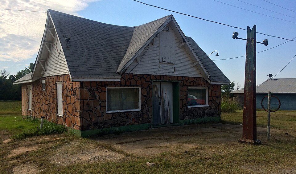
Photograph of Threatt Filling Station
Photograph by Melodibit, CC BY-SA 3.0. Via Wikimedia Commons.

Threatt Filling Station

Built in 1915. Listed on the National Register of Historic Places in 1995.

From the record

“The Threatt Filling Station, at the southwestern corner of the former U.S. Route 66 and Pottawatomi Rd. about 3 miles (4.8 km) east of Luther, Oklahoma, is a filling station built around 1915.”

Wikipedia article Threatt Filling Station, CC BY-SA 4.0.

One of 170 National Register listings published here for Oklahoma County · listed in 1995 · category: Building · built in 1915.

Sources: the Wikipedia article · the case file at the National Archives · the National Register database, National Park Service
The listing

  • What is counted as historic. The nomination lists 1 building as contributing to the listing.
  • Address. Jct. of US 66 and Pottawatomi Rd., SW corner, Luther, 73054
  • When was it listed? February 1995
  • Category. building
  • Also known as. Route 66 in Oklahoma MPS; Route 66 in Oklahoma MPS
  • Census division. Oklahoma City Northeast
  • When was it built? 1915
  • National Register reference number. 95000038 - the number the National Park Service assigned this property when it was listed, and the key its nomination file is catalogued under at the National Archives.

Fires near this property

3 since 2009

Regional context, not property-specific evidence. The federal wildfire occurrence database lists 3 fires within 5 miles of Threatt Filling Station between 2009 and 2012, burning about 3,372 acres in total. None started naturally. None was recorded as arson. Distance is straight-line from the map coordinates, so a fire counted here may appear on a neighbouring settlement's page as well.

Reported cause Fires
Missing data/not specified/undetermined2
Debris and open burning1

The most recent of them, most recent first, with the day each was reported and the service that recorded it.

DateCause SizeReported by Name on the report
3 August 2012Missing data/not specified/undetermined2,621 acresOklahoma Division of ForestryLUTHER FIRE
9 April 2009Missing data/not specified/undetermined750 acresOklahoma Division of ForestryWELLSTON
7 November 2012Debris and open burning1.0 acresPawnee Agency4 CEDAR

Every fire recorded in Oklahoma County

Storms near this property

38 since 1993

Regional context, not property-specific evidence. The National Weather Service names Luther, the town this property stands in, in 38 storm reports between 1993 and 2026: 18 hail, 11 thunderstorm wind, 3 tornado, 3 flash flood. No death or injury is recorded in these reports. Each account below is quoted exactly as the forecast office filed it, from the NOAA Storm Events Database, and each date opens the federal record of that event.

WhenEvent Place namedHarm What the report says
May 2003Tornado (F1)Luther$90,000This is the first segment of a tornado that began in Oklahoma County, south of Luther, then moved northeast paralleling Interstate 44. The tornado moved into Lincoln County before dissipating 3.3 miles south-southwest of Wellston. The first area of damage found was located a half a mile south of the intersection of Luther Road and Memorial Road (Northeast 136th Street). The damage in this area was a tree and many tree limbs downed. A house was damaged a quarter of a mile west of the intersection of Memorial Road and Dobbs Road. The house lost a room on the second floor on the south side of the house. The poorly attached roof was also lifted and thrown over with one large section staying almost intact. A shed to the north of the house was damaged with three large limbs from a silver maple found in and near the shed. A trampoline was thrown into trees about 20 yards away and bent around a trunk. A large cedar tree was also broken.The area along Dobbs Road from Memorial Road to approximately a half a mile north of Memorial Road sustained some damage. The majority of which was tree damage with many downed trees and tree limbs and several uprooted trees. An open shed, located 0.14 miles north of the intersection, had its roof peeled back towards the northeast. A mobile home also sustained some light damage in this same location. A small shed was found overturned 0.25 miles north of Memorial Road, along with sheet metal in field and a tree uprooted to the northwest of the small shed. An old mobile home, that appeared to be abandoned, was destroyed 0.3 miles north of the intersection. Across the road from the mobile home, a sheet metal barn lost its walls, but the hay was still intact. A trailer was also pushed over on to a truck in this area.A shed and scattered tree limbs were downed 0.3 miles south of the intersection of Harrah Road and Northeast 150th Street. A half a mile east of Harrah Road a large tree limb, approximately one foot in diameter, was found snapped. On the county line, 0.15 miles north of the intersection of Pottawatomie Road and EW096 Road (NE 150th Street), several tree limbs were downed.This tornado created a path 7 miles long with F1 damage sustained in the area near the intersection of Dobbs Road and Memorial Road.
August 2011Thunderstorm WindLuther$5,000Widespread tree damage continued northeast of Arcadia. Monetary damages were estimated.
June 2023Thunderstorm WindLuther$2,000Social media image showing a power pole snapped. Time is radar estimated.
May 2017Thunderstorm WindLuther$2,000Many trees downed; power poles snapped.
May 2011Thunderstorm WindLuther$2,000A large tree and metal awning were blown down. Monetary damages were estimated.
March 2026HailLuther-The report was relayed through mPING.
January 2026HailLuther-The report was relayed through mPING. The event time is adjusted based on radar observations.
June 2025FloodLuther-Roadway flooding was reported in and around the community of Luther. The event time is approximate.
July 2024Thunderstorm WindLuther-Large trees and tree limbs blown down near the intersection of Covell Road and Luther Road. Time is radar estimated.
May 2021FloodLuther-Overflowing creek.
September 2016Thunderstorm WindLuther-Estimated 50 to 55 mph sustained winds and up to 60 mph gusts with blowing dust.
May 2015Flash FloodLuther-Choctaw Rd south of Highway 66 impassable due to high water.
May 2015Flash FloodLuther-Northeast 206th Street flooded east of Peebly Road.
May 2013Tornado (EF2)Luther-A tornado touched down just south of Triple XXX Road and Coffee Creek Road to the northwest of Luther and began to move east-northeast. The tornado began producing EF2 damage soon after crossing Luther Road where an outbuilding was destroyed. At least two mobile homes were destroyed as the tornado continued to the east-northeast. The tornado crossed Waterloo Road and moved into Logan County.
May 2007Funnel CloudLuther-A funnel cloud was observed just north of the Turner Turnpike near Luther.
November 2004Tornado (F0)Luther-This weak tornado was not visually well-defined during its entire path, but media helicopters showed instances of the condensation funnel in contact with the ground. The tornado began near Luther Road between Memorial and Northeast 150th Street and ended just north of 150th Street and Dobbs. This was a rural area with no known damage.
April 2021HailLuther-no account filed
May 2021HailLuther-no account filed
April 2020HailLuther-no account filed
March 2019HailLuther-no account filed
October 2016HailLuther-no account filed
August 2015HailLuther-no account filed
March 2015HailLuther-no account filed
May 2015HailLuther-no account filed
May 2013HailLuther-no account filed
June 2008HailLuther-no account filed
May 2004Thunderstorm WindLuther-no account filed
March 2003HailLuther-no account filed
April 2001Thunderstorm WindLuther-no account filed
April 2001HailLuther-no account filed
June 1995HailLuther-no account filed
March 1994HailLuther-no account filed
May 1994Thunderstorm WindLuther-no account filed
May 1993Thunderstorm WindLuther-no account filed
August 1993Thunderstorm WindLuther-no account filed

Every storm recorded in Oklahoma County

Map coverage status

No historic map-sheet match is published for this property yet. That does not mean no map exists. This record needs a coordinate-quality review before it can be joined to a sheet boundary. Browse the county's mapped places while that work is pending.

Listed places nearby

1 within 8 miles

Other National Register properties close enough to walk or drive between, ordered by distance from this one. Both positions come from the same geocoding pass that matched these properties to their map sheets.

Photograph PropertyDistance Listed
Engels' Dry Goods Store3.1 miles1980

Sources for this property

National Archives recordThe nomination case file for reference 95000038 in Record Group 79.
Wikipedia articleCommunity-written account of this property, licensed CC BY-SA.
Oklahoma CountyAll 170 listed properties in this county.

Provenance

  • Listing record. National Park Service National Register of Historic Places, listed-properties dataset, current to 2026-05-22.
  • Map join. Address geocoded through the United States Census geocoder, then tested against the published boundary of every sheet in the USGS Historical Topographic Map Collection.
  • How this page is made. Listing fields come from federal records; map-sheet coverage is a labelled coordinate-to-boundary calculation, not a source-field claim.
  • Wildfire. Short, Karen C. 2022. Spatial wildfire occurrence data for the United States, 1992-2020 [FPA_FOD_20221014]. 6th Edition. Fort Collins, CO: Forest Service Research Data Archive. https://doi.org/10.2737/RDS-2013-0009.6 Collected with United States Government funding and usable without additional permissions or fees.
  • Storms. NOAA National Centers for Environmental Information, Storm Events Database https://www.ncei.noaa.gov/stormevents/ A work of the United States government, no copyright under 17 U.S.C. 105. Narratives are quoted verbatim from the National Weather Service report and are not edited or summarised.