 Block
From the record
One of 18 National Register listings published here for Logan County · listed in 1996 · category: Building · built in 1927.
Sources: the case file at the National Archives · the National Register database, National Park Service
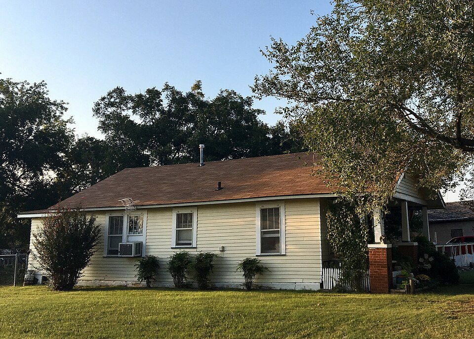
Built in 1927. Listed on the National Register of Historic Places in 1996.
One of 18 National Register listings published here for Logan County · listed in 1996 · category: Building · built in 1927.
Sources: the case file at the National Archives · the National Register database, National Park Service
Regional context, not property-specific evidence. The federal wildfire occurrence database lists 1 fire within 5 miles of Angie Debo House in 2006, burning about 1 acre in total. None started naturally. None was recorded as arson. Distance is straight-line from the map coordinates, so a fire counted here may appear on a neighbouring settlement's page as well.
| Reported cause | Fires |
|---|---|
| Missing data/not specified/undetermined | 1 |
The most recent of them, most recent first, with the day each was reported and the service that recorded it.
| Date | Cause | Size | Reported by | Name on the report |
|---|---|---|---|---|
| 12 January 2006 | Missing data/not specified/undetermined | 1.0 acres | Pawnee Agency | DOLL |
Regional context, not property-specific evidence. The federal mineral resources record lists 1 working within 5 miles of Angie Debo House: 1 past producer. None of them still produces. What was taken out: Clay. Distance is straight-line from the map coordinates, so a quarry counted here may appear on a neighbouring settlement's page as well.
| Where | Site | Commodity | Status | Recorded |
|---|---|---|---|---|
| Unknown Shale Pit | Clay | Past Producer |
Regional context, not property-specific evidence. The National Weather Service names Marshall, the town this property stands in, in 80 storm reports between 1994 and 2026: 48 thunderstorm wind, 24 hail, 5 tornado, 2 flash flood. No death or injury is recorded in these reports. Each account below is quoted exactly as the forecast office filed it, from the NOAA Storm Events Database, and each date opens the federal record of that event.
| When | Event | Place named | Harm | What the report says |
|---|---|---|---|---|
| June 2025 | Flash Flood | Marshall | $50,000 | The County Road 60 Bridge over Otter Creek was washed out due to water rise along the creek. The event time is approximate. |
| June 2005 | Thunderstorm Wind | Marshall | $50,000 | A large water tank at the local CO-OP was moved six blocks. Significant tree damage was reported. A large tree fell on a car. A trampoline became airborne and hit the house taking a corner of the roof off. The trampoline was found wrapped around a barb-wire fence. |
| May 2015 | Flash Flood | Marshall | $30,000 | Several rural roads and one bridge washed out between Marshall, Orlando and Mulhall. |
| July 2005 | Thunderstorm Wind | Marshall | $30,000 | Winds on the north side of town destroyed a 40 by 70 foot metal building at the Marshall COOP. |
| May 1999 | Tornado (F2) | Marshall | $10,000 | Tornado H4 (Logan County portion). See summary at end of May 3rd storm reports. |
| June 2005 | Thunderstorm Wind | Marshall | $3,500 | Numerous tree limbs and several trees downed. Power lines were also downed. |
| September 1998 | Thunderstorm Wind | Marshall | $10 | no account filed |
| April 2026 | Hail | Marshall | - | An image of a caliper-measured hailstone was shared on social media. The location is approximate. |
| June 2025 | Thunderstorm Wind | Marshall | - | Marshall (MRSH) Mesonet observation. |
| June 2024 | Thunderstorm Wind | Marshall | - | Marshall (MRSH) Mesonet observation. |
| June 2024 | Thunderstorm Wind | Marshall | - | Marshall (MRSH) Mesonet observation. |
| June 2024 | Thunderstorm Wind | Marshall | - | Marshall (MRSH) Mesonet observation. |
| May 2024 | Thunderstorm Wind | Marshall | - | Marshall (MRSH) Mesonet observation. |
| April 2024 | Hail | Marshall | - | Size is estimated from a live video feed. |
| June 2023 | Thunderstorm Wind | Marshall | - | Marshall (MRSH) Mesonet observation. |
| June 2023 | Thunderstorm Wind | Marshall | - | Marshall (MRSH) Mesonet observation. |
| June 2023 | Thunderstorm Wind | Marshall | - | Marshall (MRSH) Mesonet observation. |
| June 2023 | Thunderstorm Wind | Marshall | - | Marshall (MRSH) Mesonet observation. |
| August 2023 | Thunderstorm Wind | Marshall | - | Marshall (MRSH) Mesonet observation. |
| August 2023 | Thunderstorm Wind | Marshall | - | Marshall (MRSH) Mesonet observation. |
| August 2023 | Thunderstorm Wind | Marshall | - | Marshall (MRSH) Mesonet observation. |
| May 2019 | Tornado (EF0) | Marshall | - | A storm chaser observed and recorded a tornado that developed in northeast Kingfisher County and moved into northwest Logan County north of Oklahoma Highway 51 and southwest of Marshall. No damage was reported. |
| May 2010 | Tornado (EF0) | Marshall | - | Video and radar evidence suggest a mostly rain-wrapped tornado occurred from 4 miles SSE of Marshall to 4 miles SE of Marshall. No known damage occurred with the tornado. |
| October 2009 | Heavy Rain | Marshall | - | The total rainfall accumulation was 3.31 inches. |
| March 2006 | Tornado (F0) | Marshall | - | A thunderstorm produced two tornadoes east of Marshall in northern Logan county. The first brief tornado was seen by media and storm chasers touching down in open country 1 mile east of Highway 74 and 1.5 miles north of Highway 51. No damage was reported. |
| March 2006 | Tornado (F0) | Marshall | - | This was the second tornado east of Marshall produced by one thunderstorm. The very brief tornado was seen by storm chasers touching down in an open field. No known damage. |
| April 2006 | Hail | Marshall | - | Hail was observed at Highway 74 and 51. |
| August 2006 | Thunderstorm Wind | Marshall | - | Wind was measured by the Oklahoma mesonet. |
| August 2006 | Thunderstorm Wind | Marshall | - | Wind was measured by the Oklahoma mesonet. |
| August 2006 | Thunderstorm Wind | Marshall | - | Wind was measured by the Oklahoma mesonet. |
| August 2006 | Thunderstorm Wind | Marshall | - | Wind was measured by the Oklahoma mesonet. |
| May 2005 | Hail | Marshall | - | Hail was reported covering the ground. |
| June 2005 | Thunderstorm Wind | Marshall | - | Wind was measured by the Oklahoma mesonet. |
| June 2005 | Thunderstorm Wind | Marshall | - | Wind was measured by the Oklahoma mesonet. |
| July 2005 | Thunderstorm Wind | Marshall | - | Wind was measured by the Oklahoma mesonet. |
| June 2004 | Thunderstorm Wind | Marshall | - | Wind was measured by the Oklahoma mesonet. |
| June 2004 | Thunderstorm Wind | Marshall | - | Wind was measured by the Oklahoma mesonet. |
| June 2004 | Thunderstorm Wind | Marshall | - | Wind was measured by the Oklahoma mesonet. |
| May 2001 | Thunderstorm Wind | Marshall | - | Wind was measured by Oklahoma mesonet. |
| May 2001 | Thunderstorm Wind | Marshall | - | Wind was measured by Oklahoma mesonet. |
| October 1994 | Hail | Marshall | - | Severe thunderstorms in portions of northwest, north central, and central Oklahoma produced hail as large as golf balls and isolated wind gusts up to 70 mph. After several storms tracked across northcentral Oklahoma, flash flooding developed in Garfield and Kingfisher Counties. In Garfield County, water covered US Highway 81 two miles north of Bison and State Highway 132, 4 miles south of Drummond, causing several vehicles to stall. Three miles south of Waukomis US Highway 81 was closed while crews cleared 18 inches of hail and water from the roadway. In Kingfisher County, US Highway 81 was flooded 1 mile south of Hennessey. |
| April 2020 | Hail | Marshall | - | no account filed |
| May 2019 | Thunderstorm Wind | Marshall | - | no account filed |
| May 2019 | Thunderstorm Wind | Marshall | - | no account filed |
| August 2011 | Thunderstorm Wind | Marshall | - | no account filed |
| August 2011 | Thunderstorm Wind | Marshall | - | no account filed |
| July 2011 | Thunderstorm Wind | Marshall | - | no account filed |
| May 2010 | Thunderstorm Wind | Marshall | - | no account filed |
| May 2010 | Thunderstorm Wind | Marshall | - | no account filed |
| April 2009 | Hail | Marshall | - | no account filed |
| June 2007 | Thunderstorm Wind | Marshall | - | no account filed |
| June 2007 | Thunderstorm Wind | Marshall | - | no account filed |
| April 2006 | Hail | Marshall | - | no account filed |
| July 2005 | Hail | Marshall | - | no account filed |
| June 2005 | Hail | Marshall | - | no account filed |
| April 2004 | Hail | Marshall | - | no account filed |
| June 2004 | Hail | Marshall | - | no account filed |
| June 2004 | Thunderstorm Wind | Marshall | - | no account filed |
| July 2004 | Hail | Marshall | - | no account filed |
| March 2003 | Hail | Marshall | - | no account filed |
No historic map-sheet match is published for this property yet. That does not mean no map exists. This record needs a coordinate-quality review before it can be joined to a sheet boundary. Browse the county's mapped places while that work is pending.
Other National Register properties close enough to walk or drive between, ordered by distance from this one. Both positions come from the same geocoding pass that matched these properties to their map sheets.
| Photograph | Property | Distance | Listed |
|---|---|---|---|
 | Methodist Church of Marshall | under 500 feet | 1984 |
| National Archives record | The nomination case file for reference 96000379 in Record Group 79. |
| Logan County | All 18 listed properties in this county. |