
BlockBefore
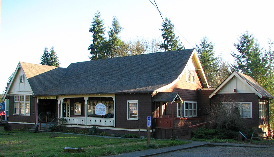
Photograph of Vernonia Pioneer Museum
Photograph by Ian Poellet ( User:Werewombat ), CC BY-SA 3.0. Via Wikimedia Commons.

Oregon-American Lumber Company Mill Office

Listed on the National Register of Historic Places in 2002.

From the record

“The Vernonia Pioneer Museum is a history museum, located in Vernonia, Oregon, United States. The building that houses the museum is listed on the National Register of Historic Places as the Oregon-American Lumber Company Mill Office.”

Wikipedia article Vernonia Pioneer Museum, CC BY-SA 4.0.

One of 11 National Register listings published here for Columbia County · listed in 2002 · category: Building.

Sources: the Wikipedia article · the case file at the National Archives · the National Register database, National Park Service

The listing

  • What is counted as historic. The nomination lists 1 building as contributing to the listing.
  • Listed as. Oregon--American Lumber Company Mill Office - the National Register files a house under its owner's surname.
  • Address. 511 East Bridge St., Vernonia, 97064
  • When was it listed? December 2002
  • Category. building
  • Census division. Vernonia
  • National Register reference number. 02001485 - the number the National Park Service assigned this property when it was listed, and the key its nomination file is catalogued under at the National Archives.

Fires near this property

43 since 1992

Regional context, not property-specific evidence. The federal wildfire occurrence database lists 43 fires within 5 miles of Oregon-American Lumber Company Mill Office between 1992 and 2019, burning about 13 acres in total. 1 started naturally. 2 were recorded as arson. Distance is straight-line from the map coordinates, so a fire counted here may appear on a neighbouring settlement's page as well.

Reported cause Fires
Debris and open burning13
Smoking7
Recreation and ceremony7
Equipment and vehicle use6
Missing data/not specified/undetermined2
Other causes2
Arson/incendiarism2
Power generation/transmission/distribution1
Firearms and explosives use1
Misuse of fire by a minor1
Natural1

The most recent of them, most recent first, with the day each was reported and the service that recorded it.

DateCause SizeReported by Name on the report
9 September 2018Debris and open burningunder an acreOregon Department of Forestry Salem HeadquartersLOUISIANA AVE #1
9 September 2007Power generation/transmission/distributionunder an acreColumbia City UnitSHEELY CREEK
6 September 2011Equipment and vehicle useunder an acreColumbia City UnitNEHALEM HWY S. #3
28 September 2017Debris and open burning2.6 acresOregon Department of Forestry Salem HeadquartersKIRK RD. #1
28 September 2002Equipment and vehicle useunder an acreColumbia City UnitPETERSON CROSSOVER RD #1
28 September 1999Smokingunder an acreColumbia City UnitSHORT ROAD #1
17 September 2007Debris and open burningunder an acreColumbia City UnitNEHALEM HWY N. #1
12 September 1996Equipment and vehicle useunder an acreColumbia City UnitREMINGTON

Every fire recorded in Columbia County

Mines and quarries near this property

10 of 15 shown

Regional context, not property-specific evidence. The federal mineral resources record lists 15 workings within 5 miles of Oregon-American Lumber Company Mill Office: 14 past producers, 1 producer. 1 still produces. What was taken out: Stone, Crushed/Broken, Stone. Distance is straight-line from the map coordinates, so a quarry counted here may appear on a neighbouring settlement's page as well.

Where SiteCommodity StatusRecorded
ArchibaldStonePast Producer
Crown ZellerbachStonePast Producer
Crown Zellerbach Mansfield LookoutStonePast Producer
Crown Zellerbach New MansfieldStonePast Producer
Oak Ranch Pit 1 & 2StonePast Producer
Archibald PitStone, Crushed/BrokenPast Producer
Crown ZellerbachStone, Crushed/BrokenPast Producer

Every working recorded in Columbia County

Storms near this property

7 since 2007

Regional context, not property-specific evidence. The National Weather Service names Vernonia, the town this property stands in, in 7 storm reports between 2007 and 2021: 6 flood, 1 heavy rain. The reports record 1 death and 1 injury. Each account below is quoted exactly as the forecast office filed it, from the NOAA Storm Events Database, and each date opens the federal record of that event.

WhenEvent Place namedHarm What the report says
December 2015FloodVernonia1 killed, 1 hurt, $2,305,000The Nehalem River near Vernonia flooded Vernonia resulting in evacuation of residents and damage to many buildings and vehicles. A bridge washed out on TImber Road and isolated the Glenwood Community. There was also significant flooding in St Helens, where 17 homes were evacuated, and many roads were damaged and closed. Highway 30 and the business district in Rainier also flooded. An elderly couple drove around a barrier of a closed road, and was swept away by high water. The man escaped through the sunroof of the vehicle, but the woman ended up drowning. Flooding and landslides cut off Western Columbia County.
December 2007FloodVernonia$36,000,000The Upper Nehalem River flooded near Vernonia, and did devastating damage to the city. Numerous homes were completely flooded, and many families were evacuated. Quite a few lost everything they had. NOTE: Damage estimates are for the entire Columbia county, with almost a third of the damage in the town of Vernonia.
December 2015FloodVernonia$824,000Flooding from the Nehalem River and Rock Creek in Vernonia resulted in evacuation of homes and the implementation of the Vernonia Emergency Command Center. Heavy rain resulted in a land slide that closed OR47 at mile marker 8.
December 2015FloodVernonia$124,000Heavy rain resulted in flooding of the Nehalem River near Vernonia, and several small streams in the area. The Timber Road Bridge over Gales Creek washed out north of Highway 6.
January 2021FloodVernonia-The Nehalem River near Vernonia (VENO3) rose above flood stage at 0215PST, crested at 12.17 feet, the fell below flood stage at 0345PST on the 13th. Flood stage is 12.0 feet.
November 2012FloodVernonia-Heavy rain caused the Nehalem River near Vernonia to overflow its banks and flood low lying areas. The Nehalem River crested at 13.4 feet, 1.4 feet above flood stage, on November 19th at 5 pm PST.
December 2007Heavy RainVernonia-Storm total precipitation was 11.00 inches.

Every storm recorded in Columbia County

Map coverage status

No historic map-sheet match is published for this property yet. That does not mean no map exists. This record needs a coordinate-quality review before it can be joined to a sheet boundary. Browse the county's mapped places while that work is pending.

Sources for this property

National Archives recordThe nomination case file for reference 02001485 in Record Group 79.
Wikipedia articleCommunity-written account of this property, licensed CC BY-SA.
Columbia CountyAll 11 listed properties in this county.

Provenance

  • Listing record. National Park Service National Register of Historic Places, listed-properties dataset, current to 2026-05-22.
  • Map join. Address geocoded through the United States Census geocoder, then tested against the published boundary of every sheet in the USGS Historical Topographic Map Collection.
  • How this page is made. Listing fields come from federal records; map-sheet coverage is a labelled coordinate-to-boundary calculation, not a source-field claim.
  • Wildfire. Short, Karen C. 2022. Spatial wildfire occurrence data for the United States, 1992-2020 [FPA_FOD_20221014]. 6th Edition. Fort Collins, CO: Forest Service Research Data Archive. https://doi.org/10.2737/RDS-2013-0009.6 Collected with United States Government funding and usable without additional permissions or fees.
  • Mines and quarries. USGS Mineral Resources Data System (MRDS) https://mrdata.usgs.gov/mrds/ A work of the United States government, no copyright under 17 U.S.C. 105.
  • Storms. NOAA National Centers for Environmental Information, Storm Events Database https://www.ncei.noaa.gov/stormevents/ A work of the United States government, no copyright under 17 U.S.C. 105. Narratives are quoted verbatim from the National Weather Service report and are not edited or summarised.