 Block
From the record
11 National Register listings published here.
Sources: the National Register database, National Park Service
96 topographic sheets cover 47 settlements here, and 11 properties are on the National Register of Historic Places.
11 National Register listings published here.
Sources: the National Register database, National Park Service
Every property in this county listed on the National Register of Historic Places, with the year it was listed and the federal nomination document.
| Photograph | Property | Type | Listed | Reference |
|---|---|---|---|---|
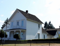 | Dr. Charles G. and Lucinda McBride Caples Farmstead | building | 2005 | 05001060 |
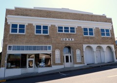 | Clatskanie IOOF Hall | building | 2012 | 12000078 |
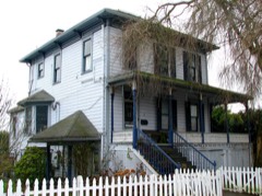 | Cox-Williams House | building | 1982 | 82001501 |
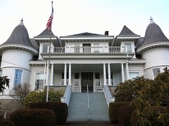 | Thomas J. Flippin House | building | 1979 | 79002048 |
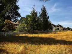 | John and Carolena Heimuller Farmstead | building | 2011 | 11000049 |
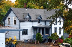 | George F. Moeck House | building | 1978 | 78002283 |
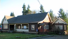 | Oregon-American Lumber Company Mill Office | building | 2002 | 02001485 |
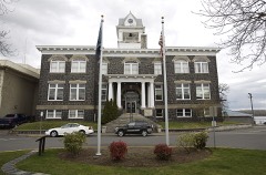 | St. Helens Downtown Historic District | district | 1984 | 84000137 |
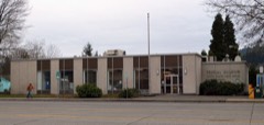 | United States Post Office (Scappoose) | building | 2017 | 100000618 |
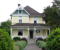 | James Grant Watts House | building | 1980 | 80003308 |
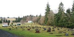 | Woodbine Cemetery-Green Mountain Cemetery | site | 2001 | 01000829 |
Every wildfire the federal occurrence database records inside this county: 445 of them, burning about 478 acres. 22 started naturally and 13 were recorded as arson. Each settlement page carries the fires within five miles of it.
| Reported cause | Fires |
|---|---|
| Debris and open burning | 141 |
| Equipment and vehicle use | 69 |
| Smoking | 53 |
| Recreation and ceremony | 51 |
| Missing data/not specified/undetermined | 35 |
| Misuse of fire by a minor | 23 |
| Natural | 22 |
| Other causes | 15 |
| Arson/incendiarism | 13 |
| Power generation/transmission/distribution | 12 |
| Fireworks | 10 |
| Firearms and explosives use | 1 |
The five largest, by the area the report gives. One of them was set deliberately.
| Date | Cause | Size | Reported by | Name on the report |
|---|---|---|---|---|
| 13 June 2015 | Missing data/not specified/undetermined | 67 acres | Oregon Department of Forestry Salem Headquarters | SUNSET GRADE#1 |
| 3 June 2018 | Missing data/not specified/undetermined | 42 acres | Oregon Department of Forestry Salem Headquarters | CHAPMAN GRANGE#1 |
| 10 June 1994 | Equipment and vehicle use | 37 acres | Columbia City Unit | EMERALD FOREST |
| 24 April 1999 | Debris and open burning | 31 acres | Columbia City Unit | WOLDEN ROAD FIRE #1 |
| 27 May 1992 | Equipment and vehicle use | 31 acres | Columbia City Unit | KERRY ROAD |
| 16 July 2017 | Arson/incendiarism | 30 acres | Oregon Department of Forestry Salem Headquarters | HWY 47 MP 5 |
| 19 August 2009 | Equipment and vehicle use | 23 acres | Columbia City Unit | FLORA RD. #1 |
| 24 April 1999 | Debris and open burning | 20 acres | Columbia City Unit | LOST CREEK ROAD #1 |
Every settlement page carries the fires within five miles of it - see the settlement index below.
The NOAA Storm Events Database holds 31 reports for this county, causing 1 death, 2 injuries and about $39,410,500 in recorded property damage. Each settlement page carries the reports that name it.
| Kind of event | Reports |
|---|---|
| Flood | 12 |
| Heavy Rain | 9 |
| Tornado | 5 |
| Hail | 3 |
| Funnel Cloud | 2 |
The most serious of them, by death, then injury, then recorded damage. The accounts are quoted exactly as the forecast office filed them.
| When | Event | Place named | Harm | What the report says |
|---|---|---|---|---|
| December 2015 | Flood | Vernonia | 1 killed, 1 hurt, $2,305,000 | The Nehalem River near Vernonia flooded Vernonia resulting in evacuation of residents and damage to many buildings and vehicles. A bridge washed out on TImber Road and isolated the Glenwood Community. There was also significant flooding in St Helens, where 17 homes were evacuated, and many roads were damaged and closed. Highway 30 and the business district in Rainier also flooded. An elderly couple drove around a barrier of a closed road, and was swept away by high water. The man escaped through the sunroof of the vehicle, but the woman ended up drowning. Flooding and landslides cut off Western Columbia County. |
| April 2000 | Tornado (F0) | St Helens | 1 hurt, $35,000 | An F0 tornado touched down near Old Portland Road and Kastor Road in St. Helens. A tree was blown over across a fence adjacent to Old Portland Road and in front of the McCormick Park apartment building. Another tree was broken off and fell across the apartment building. Limbs broken off and picked up by the winds resulted in one broken window and one minor injury. One apartment occupant, who was on her balcony at the time, was hit in the shoulder by an airborne limb. There was about $35,000 damage to the building and fence. There were no fatalities. |
| December 2007 | Flood | Vernonia | $36,000,000 | The Upper Nehalem River flooded near Vernonia, and did devastating damage to the city. Numerous homes were completely flooded, and many families were evacuated. Quite a few lost everything they had. NOTE: Damage estimates are for the entire Columbia county, with almost a third of the damage in the town of Vernonia. |
| December 2015 | Flood | Vernonia | $824,000 | Flooding from the Nehalem River and Rock Creek in Vernonia resulted in evacuation of homes and the implementation of the Vernonia Emergency Command Center. Heavy rain resulted in a land slide that closed OR47 at mile marker 8. |
| December 2015 | Flood | Vernonia | $124,000 | Heavy rain resulted in flooding of the Nehalem River near Vernonia, and several small streams in the area. The Timber Road Bridge over Gales Creek washed out north of Highway 6. |
| November 2020 | Tornado (EF0) | St Helens | $40,000 | A tornado touched down around 12:20 PM in Northwest St. Helens, OR near the intersection of Pittsburgh and Robnette Road. The tornado moved southeastward, ending near just east of McBride Elementary School. The most damage was done near Barr Ave and Pittsburgh Road, with damage to trees, a camper, fences and snapped power lines. |
| February 2019 | Flood | Rainier | $30,000 | Several structures impacted from flooding along Fox Creek in the city of Rainier, Oregon. Eventual cause may have been a blocked culvert. U.S. Highway 30 was closed at times. |
| January 2022 | Flood | Mist | $25,000 | Oregon highway 47 near the Mist junction was closed due to a culvert failing, washing out the road. |
| August 1978 | Tornado (F1) | not stated | $25,000 | no account filed |
| November 1965 | Tornado (F0) | not stated | $2,500 | no account filed |
| January 2021 | Flood | Vernonia | - | The Nehalem River near Vernonia (VENO3) rose above flood stage at 0215PST, crested at 12.17 feet, the fell below flood stage at 0345PST on the 13th. Flood stage is 12.0 feet. |
| October 2018 | Funnel Cloud | Scappoose | - | A viewer sent in a photo to a local news station of a funnel cloud over the Multnomah Channel, observed around 11 AM. |
| May 2017 | Hail | Vernonia Arpt | - | Received picture via Twitter of hail around 1 inch in diameter from Timber road SW of Vernonia. |
| February 2017 | Flood | Braun | - | Heavy rain caused the Upper Nehalem River near Vernonia to flood. The river crested at 12.77 feet, which is 0.77 feet above flood stage. |
| November 2016 | Flood | Braun | - | Heavy rain resulted in flooding of the Nehalem River near Vernonia. The Nehalem River reached flood stage at 915 PM on November 24th, and crested at 12.5 feet at 1246 AM on November 25th. The river dropped below flood stage at 418 AM on November 25. |
| November 2012 | Flood | Vernonia | - | Heavy rain caused the Nehalem River near Vernonia to overflow its banks and flood low lying areas. The Nehalem River crested at 13.4 feet, 1.4 feet above flood stage, on November 19th at 5 pm PST. |
| July 2011 | Funnel Cloud | Clatskanie | - | A concerned citizen sent photos to the local National Weather Service office Sunday evening of a funnel cloud that formed over Clatskanie, Oregon. |
| January 2009 | Flood | Mist | - | Heavy rain combined with snowmelt runoff caused high water on highway 47 near Mist. |
| January 2009 | Flood | Clatskanie | - | Heavy caused small streams and creeks to overflow their banks that resulted in water covering highway 30 near Clatskanie. |
| December 2007 | Heavy Rain | Vernonia | - | Storm total precipitation was 11.00 inches. |
| December 2007 | Heavy Rain | Scappoose | - | Storm total precipitation was 5.97 inches. |
| December 2007 | Heavy Rain | Mist | - | Storm total precipitation was 8.65 inches at the Miller RAWS. |
| June 2004 | Tornado (F0) | Rainier | - | Cowlitz county, Washington dispatch received several reports of a tornado that touched down on the Oregon side of the Columbia River, about 3 miles southeast of Rainier, crossed the river to the mouth of the Kalama River as a waterspout, and moved onshore on the Washington side as a tornado. |
| January 2004 | Heavy Rain | Countywide | - | no account filed |
| December 2003 | Heavy Rain | Countywide | - | no account filed |
| January 2003 | Heavy Rain | Countywide | - | no account filed |
| March 2003 | Heavy Rain | Countywide | - | no account filed |
| March 2003 | Heavy Rain | Countywide | - | no account filed |
| August 2001 | Heavy Rain | Countywide | - | no account filed |
| July 1991 | Hail | not stated | - | no account filed |
| July 1955 | Hail | not stated | - | no account filed |
The Survey's mineral resources record lists 259 workings inside this county. 69 still produce and 190 are closed or unrecorded. Each settlement page carries the workings within five miles of it.
| Commodity | Workings |
|---|---|
| Stone | 101 |
| Stone, Crushed/Broken | 100 |
| Sand and Gravel, Construction | 35 |
| Iron | 15 |
| Aluminum | 11 |
| Titanium, Iron | 2 |
| Aluminum, Iron, Titanium, Metal | 1 |
| Titanium, Metal, Aluminum, Iron | 1 |
| Aluminum, Iron | 1 |
| Titanium, Metal | 1 |
| Iron, Mineral Pigments | 1 |
| Iron, Titanium, Silica, Phosphorus-Phosphates, Water, Free | 1 |
| Clay | 1 |
The least common of them first, because a county's hundredth gravel pit says nothing its first ten did not.
| Where | Site | Commodity | Status | Recorded |
|---|---|---|---|---|
| Bauxite Columbia County | Aluminum, Iron, Titanium, Metal | Occurrence | Gibbsite, Limonite | |
| Bauxite Kalama-Rainer | Aluminum, Iron, Titanium, Metal | Occurrence | ||
| Bauxite Scapoose - St Helens | Titanium, Metal, Aluminum, Iron | Occurrence | Limonite | |
| Columbia County Bauxite Deposits | Aluminum, Iron, Titanium, Silica, Phosphorus-Phosphates, Water, Free | Prospect | 1944 | |
| Scappoose Iron | Iron, Mineral Pigments | Producer | Limonite | |
| Sig Fransen Clay Pit | Clay | Past Producer | ||
| Columbia County Bauxite | Aluminum, Titanium, Iron | Occurrence | ||
| Scapoose-St. Helens Bauxite | Aluminum, Titanium, Iron | Occurrence | ||
| Dowd School | Aluminum, Iron | Occurrence | ||
| Happy Hollow | Aluminum, Iron | Occurrence | ||
| Kalama-Ranier Bauxite Occurrence | Aluminum | Occurrence | ||
| Marshall Farm | Aluminum, Iron | Occurrence | ||
| Oester | Aluminum, Iron | Occurrence | ||
| Spitzenberg | Aluminum, Iron | Occurrence | ||
| Trenholm | Aluminum, Iron | Occurrence | ||
| Yankton and Alder Creek | Iron, Aluminum | Occurrence | ||
| Bunker Hill Iron Deposit | Iron | Occurrence | ||
| Colport Charcoal Iron | Iron | Occurrence | ||
| Ironcrest Iron | Iron | Occurrence | ||
| Ladysmith | Iron | Occurrence | ||
| Maple Hill Iron | Iron | Occurrence | ||
| Scappoose Coal Prospect | Iron | Unknown | ||
| Scappoose Iron | Iron | Occurrence | Limonite | |
| Scappoose Iron | Iron | Occurrence | ||
| A. Bergman | Sand and Gravel, Construction | Past Producer | ||
| A. Bergman | Sand and Gravel, Construction | Past Producer | ||
| Columbia West Materials & Constr | Sand and Gravel, Construction | Past Producer | ||
| Columbia West Materials & Constr. | Sand and Gravel, Construction | Producer | ||
| Crown Zellerbach | Sand and Gravel, Construction | Past Producer | ||
| Crown Zellerbach | Sand and Gravel, Construction | Past Producer | ||
| Deer Island | Sand and Gravel, Construction | Producer | ||
| Deer Island Pit | Sand and Gravel, Construction | Past Producer | ||
| Deer Island Sand & Gravel Pit & Pl | Sand and Gravel, Construction | Past Producer | ||
| Gravel Pit | Sand and Gravel, Construction | Past Producer | ||
| Gravel Pit | Sand and Gravel, Construction | Past Producer | ||
| Gravel Pit | Sand and Gravel, Construction | Past Producer | ||
| Oregon State Highway Division | Sand and Gravel, Construction | Past Producer | ||
| Oregon State Highway Division | Sand and Gravel, Construction | Past Producer | ||
| Pacific Building Materials Santosh | Sand and Gravel, Construction | Producer | ||
| Paul Zimmerly Road Construction | Sand and Gravel, Construction | Past Producer | ||
| Paul Zimmerly Road Construction | Sand and Gravel, Construction, Stone, Crushed/Broken | Producer | ||
| Peter-Billy-Glenn Tree Farm | Sand and Gravel, Construction | Past Producer | ||
| Quarry | Sand and Gravel, Construction | Past Producer | ||
| Santosh Pit & Pl | Sand and Gravel, Construction | Past Producer | ||
| Santosh Pit and Plant | Sand and Gravel, Construction | Past Producer | ||
| Scappoose Sand and Gravel | Sand and Gravel, Construction | Past Producer | ||
| Scappoose Sand and Gravel | Sand and Gravel, Construction | Producer | ||
| St. Helens Quarry | Sand and Gravel, Construction | Past Producer | ||
| St. Helens Quarry | Sand and Gravel, Construction | Producer | ||
| T. Johnson | Sand and Gravel, Construction | Past Producer | ||
| T. Johnson | Sand and Gravel, Construction | Past Producer | ||
| Trojan Lakes | Sand and Gravel, Construction | Past Producer | ||
| Trojan Lakes | Sand and Gravel, Construction | Unknown | ||
| Unnamed Pit | Sand and Gravel, Construction | Producer | ||
| Unnamed Pit | Sand and Gravel, Construction | Producer | ||
| Unnamed Pit | Sand and Gravel, Construction | Producer | ||
| Unnamed Quarry | Sand and Gravel, Construction | Past Producer | ||
| Warren Sand & Gravel Co. | Sand and Gravel, Construction | Past Producer | ||
| Warren Sand & Gravel Co. | Sand and Gravel, Construction | Producer | ||
| Archibald Pit | Stone, Crushed/Broken | Past Producer | ||
| Babler Bros. | Stone, Crushed/Broken | Past Producer | ||
| Bernards Excavating | Stone, Crushed/Broken | Producer | ||
| Boise Cascade | Stone, Crushed/Broken | Past Producer | ||
| C. Aniker | Stone, Crushed/Broken | Producer | ||
| C. H. May | Stone, Crushed/Broken | Producer | ||
| C. Zimmermann | Stone, Crushed/Broken | Producer | ||
| Columbia County | Stone, Crushed/Broken | Past Producer | ||
| Columbia County | Stone, Crushed/Broken | Past Producer | ||
| Columbia West Pit | Stone, Crushed/Broken | Producer | ||
| Corth | Stone, Crushed/Broken | Past Producer | ||
| Crown Zellerbach | Stone, Crushed/Broken | Past Producer | ||
| Crown Zellerbach | Stone, Crushed/Broken | Past Producer | ||
| Crown Zellerbach | Stone, Crushed/Broken | Past Producer | ||
| Crown Zellerbach | Stone, Crushed/Broken | Past Producer | ||
| Crown Zellerbach | Stone, Crushed/Broken | Producer | ||
| Crown Zellerbach | Stone, Crushed/Broken | Past Producer | ||
| Crown Zellerbach | Stone, Crushed/Broken | Past Producer | ||
| Crown Zellerbach | Stone, Crushed/Broken | Past Producer | ||
| Crown Zellerbach | Stone, Crushed/Broken | Past Producer | ||
| Crown Zellerbach | Stone, Crushed/Broken | Past Producer | ||
| Crown Zellerbach | Stone, Crushed/Broken | Producer | ||
| Crown Zellerbach Mansfield Lookout | Stone, Crushed/Broken | Past Producer | ||
| Crown Zellerbach New Mansfield | Stone, Crushed/Broken | Producer | ||
| Crown Zellerbach Oak Ranch Quarry | Stone, Crushed/Broken | Producer | ||
| D. F. Salzman | Stone, Crushed/Broken | Past Producer | ||
| Deal Pit | Stone, Crushed/Broken | Past Producer | ||
| Deane S. Chappell Rock & Const. | Stone, Crushed/Broken | Producer | ||
| Dwight Irby | Stone, Crushed/Broken | Producer | ||
| E. Johnson | Stone, Crushed/Broken | Past Producer | ||
| E. Musgrove | Stone, Crushed/Broken | Producer | ||
| Evanson, Et Al | Stone, Crushed/Broken | Producer | ||
| Evanson, Et Al | Stone, Crushed/Broken | Producer | ||
| F. Sutter | Stone, Crushed/Broken | Producer | ||
| Goble Pit | Stone, Crushed/Broken | Producer | ||
| Graham Pit and Plant | Stone, Crushed/Broken | Past Producer | ||
| Grahm Pit & Plant | Stone, Crushed/Broken | Producer | ||
| I Jones | Stone, Crushed/Broken | Past Producer | ||
| Just-A-Mere Farm Inc | Stone, Crushed/Broken | Past Producer | ||
| Just-A-Mere Farm, Inc. | Stone, Crushed/Broken | Producer | ||
| L. Estund | Stone, Crushed/Broken | Producer | ||
| Longview Fiber | Stone, Crushed/Broken | Producer | ||
| Longview Fiber | Stone, Crushed/Broken | Past Producer | ||
| Longview Fiber | Stone, Crushed/Broken | Producer | ||
| Longview Fiber | Stone, Crushed/Broken | Producer | ||
| Longview Fiber | Stone, Crushed/Broken | Producer | ||
| Longview Fiber | Stone, Crushed/Broken | Producer | ||
| Longview Fiber | Stone, Crushed/Broken | Past Producer | ||
| Longview Fiber | Stone, Crushed/Broken | Producer | ||
| Longview Fiber | Stone, Crushed/Broken | Past Producer | ||
| Longview Fiber | Stone, Crushed/Broken | Producer | ||
| Longview Fiber | Stone, Crushed/Broken | Producer | ||
| Longview Fiber | Stone, Crushed/Broken | Producer | ||
| Longview Fiber | Stone, Crushed/Broken | Producer | ||
| Longview Fiber | Stone, Crushed/Broken | Producer | ||
| Longview Fiber | Stone, Crushed/Broken | Past Producer | ||
| Longview Fiber | Stone, Crushed/Broken | Producer | ||
| Longview Fiber | Stone, Crushed/Broken | Producer | ||
| Longview Fiber | Stone, Crushed/Broken | Producer | ||
| Longview Fiber | Stone, Crushed/Broken | Past Producer | ||
| Longview Fiber | Stone, Crushed/Broken | Producer | ||
| Longview Fiber | Stone, Crushed/Broken | Past Producer | ||
| Longview Fiber | Stone, Crushed/Broken | Producer | ||
| Longview Fiber | Stone, Crushed/Broken | Past Producer | ||
| Longview Fiber | Stone, Crushed/Broken | Producer | ||
| Longview Fiber Rocky Point | Stone, Crushed/Broken | Producer | ||
| Mayger Pit | Stone, Crushed/Broken | Producer | ||
| Mcatee | Stone, Crushed/Broken | Past Producer | ||
| Neuman | Stone, Crushed/Broken | Producer | ||
| Oak Ranch Pit | Stone, Crushed/Broken | Past Producer | ||
| Oak Ranch Pit No. 2 | Stone, Crushed/Broken | Past Producer | ||
| Oregon State Highway Division | Stone, Crushed/Broken | Producer | ||
| Oregon State Highway Division | Stone, Crushed/Broken | Producer | ||
| Oregon State Highway Division | Stone, Crushed/Broken | Past Producer | ||
| Pete Matiaco | Stone, Crushed/Broken | Producer | ||
| Peterson | Stone, Crushed/Broken | Producer | ||
| Publishers Paper | Stone, Crushed/Broken | Producer | ||
| R. Olson | Stone, Crushed/Broken | Producer | ||
| Rainier Quarry | Stone, Crushed/Broken | Producer | ||
| Rainier Quarry & Plant | Stone, Crushed/Broken | Producer | ||
| Ruth Realty Co. | Stone, Crushed/Broken | Past Producer | ||
| St. Helens Quarry and Plant | Stone, Crushed/Broken | Producer | ||
| Stimson Timber Co. | Stone, Crushed/Broken | Past Producer | ||
| Tide Creek Rock | Stone, Crushed/Broken | Producer | ||
| Tide Creek Rock, Inc | Stone, Crushed/Broken | Producer | ||
| Unnamed Pit | Stone, Crushed/Broken | Past Producer | ||
| Unnamed Pit | Stone, Crushed/Broken | Producer | ||
| Unnamed Quarry | Stone, Crushed/Broken | Past Producer | ||
| Unnamed Quarry | Stone, Crushed/Broken | Producer | ||
| Unnamed Quarry | Stone, Crushed/Broken | Past Producer | ||
| Unnamed Quarry | Stone, Crushed/Broken | Producer | ||
| Unnamed Quarry | Stone, Crushed/Broken | Past Producer | ||
| Unnamed Quarry | Stone, Crushed/Broken | Producer | ||
| W. Evenson | Stone, Crushed/Broken | Producer | ||
| W. Evenson | Stone, Crushed/Broken | Past Producer | ||
| W. Evenson | Stone, Crushed/Broken | Producer | ||
| W. Evenson | Stone, Crushed/Broken | Past Producer | ||
| W. Evenson | Stone, Crushed/Broken | Past Producer | ||
| Watters Quarry | Stone, Crushed/Broken | Producer | ||
| Archibald | Stone | Past Producer | ||
| B & B Pit | Stone | Past Producer | ||
| Babler Bros. | Stone | Past Producer | ||
| Bernards Excavating | Stone | Past Producer | ||
| Boise Cascade | Stone | Past Producer | ||
| Bonneville Power Administration | Stone | Past Producer | ||
| C Aniker | Stone | Past Producer | ||
| C H May | Stone | Past Producer | ||
| C Zimmermann | Stone | Past Producer | ||
| Chapple Pit | Stone | Past Producer | ||
| Columbia County | Stone | Past Producer | ||
| Columbia County | Stone | Past Producer | ||
| Columbia County | Stone | Past Producer | ||
| Columbia West | Stone | Past Producer | ||
| Columbia West Materials & Const | Stone | Past Producer | ||
| Corth | Stone | Past Producer | ||
| Crown Zellerbach | Stone | Past Producer | ||
| Crown Zellerbach | Stone | Past Producer | ||
| Crown Zellerbach | Stone | Past Producer | ||
| Crown Zellerbach | Stone | Past Producer | ||
| Crown Zellerbach | Stone | Past Producer | ||
| Crown Zellerbach | Stone | Past Producer | ||
| Crown Zellerbach | Stone | Past Producer | ||
| Crown Zellerbach | Stone | Past Producer | ||
| Crown Zellerbach | Stone | Past Producer | ||
| Crown Zellerbach | Stone | Past Producer | ||
| Crown Zellerbach | Stone | Past Producer | ||
| Crown Zellerbach Mansfield Lookout | Stone | Past Producer | ||
| Crown Zellerbach New Mansfield | Stone | Past Producer | ||
| D F Salzman | Stone | Past Producer | ||
| Dwight Irby | Stone | Past Producer | ||
| E Johnson | Stone | Past Producer | ||
| E. Musgrove | Stone | Past Producer | ||
| Evanson Et Al | Stone | Past Producer | ||
| Evanson Et Al | Stone | Past Producer | ||
| F. Sutter | Stone | Past Producer | ||
| Goble Quarry | Stone | Past Producer | ||
| Graham Pit and Plant | Stone | Past Producer | ||
| Grahm Pit & Plant | Stone | Past Producer | ||
| I Jones | Stone | Past Producer | ||
| Just-A-Mere Farm Inc | Stone | Past Producer | ||
| Just-A-Mere Farm Inc | Stone | Past Producer | ||
| L Estund | Stone | Past Producer | ||
| Les Brady | Stone | Past Producer | ||
| Les Brady | Stone | Producer | ||
| Longview Fiber | Stone | Past Producer | ||
| Longview Fiber | Stone | Past Producer | ||
| Longview Fiber | Stone | Past Producer | ||
| Longview Fiber | Stone | Past Producer | ||
| Longview Fiber | Stone | Past Producer | ||
| Longview Fiber | Stone | Past Producer | ||
| Longview Fiber | Stone | Past Producer | ||
| Longview Fiber | Stone | Past Producer | ||
| Longview Fiber | Stone | Past Producer | ||
| Longview Fiber | Stone | Past Producer | ||
| Longview Fiber | Stone | Past Producer | ||
| Longview Fiber | Stone | Past Producer | ||
| Longview Fiber | Stone | Past Producer | ||
| Longview Fiber | Stone | Past Producer | ||
| Longview Fiber | Stone | Past Producer | ||
| Longview Fiber | Stone | Past Producer | ||
| Longview Fiber | Stone | Past Producer | ||
| Longview Fiber | Stone | Past Producer | ||
| Longview Fiber | Stone | Past Producer | ||
| Longview Fiber | Stone | Past Producer | ||
| Longview Fiber | Stone | Past Producer | ||
| Longview Fiber | Stone | Past Producer | ||
| Longview Fiber | Stone | Past Producer | ||
| Longview Fiber | Stone | Past Producer | ||
| Longview Fiber Rocky Point | Stone | Past Producer | ||
| Mayger Pit | Stone | Past Producer | ||
| Mcatee | Stone | Past Producer | ||
| Neuman | Stone | Past Producer | ||
| Oak Ranch Pit 1 & 2 | Stone | Past Producer | ||
| Oak Ranch Quarry #1 | Stone | Past Producer | ||
| Oak Ranch Quarry #2 | Stone | Past Producer | ||
| Oregon State Highway Division | Stone | Past Producer | ||
| Oregon State Highway Division | Stone | Past Producer | ||
| Oregon State Highway Division | Stone | Past Producer | ||
| Pete Matiaco | Stone | Past Producer | ||
| Peter-Billy-Glenn Tree Farm | Stone | Past Producer | ||
| Peterson | Stone | Past Producer | ||
| Publishers Paper | Stone | Past Producer | ||
| Quarry | Stone | Past Producer | ||
| Quarry | Stone | Past Producer | ||
| Quarry | Stone | Past Producer | ||
| Quarry | Stone | Past Producer | ||
| Quarry | Stone | Past Producer | ||
| R. Olson | Stone | Past Producer | ||
| Ruth Realty Co. | Stone | Past Producer | ||
| Stimson Timber Co. | Stone | Past Producer | ||
| Tide Creek Pit | Stone | Past Producer | ||
| Tide Creek Rock | Stone | Past Producer | ||
| Unknown | Stone | Past Producer | ||
| W Evenson | Stone | Past Producer | ||
| W. Evenson | Stone | Past Producer | ||
| W. Evenson | Stone | Past Producer | ||
| W. Evenson | Stone | Past Producer | ||
| W. Evenson | Stone | Past Producer | ||
| Waters Concrete Products Inc. | Stone | Past Producer | ||
| Watters Quarry | Stone | Past Producer |
Named settlements recorded in the Geographic Names Information System, each with the topographic sheets covering it. Villages, hamlets and abandoned places alike. Each is shown with the nearest named watercourse or landform and the survey quadrangle it falls on.
Rainier census division · 97048 · On South Fork Beaver Creek · Delena quadrangle
15 sheets, 1919 to 1985
St. Helens census division · 97053 · On Cox Creek · Saint Helens quadrangle
18 sheets, 1922 to 1990
No longer a settlement
Goble census division · 97048 · On Welter Creek · Rainier quadrangle
12 sheets, 1921 to 1990
Goble census division · 97048 · On East Branch Fox Creek · Rainier quadrangle
12 sheets, 1921 to 1990
Vernonia census division · 97016 · On Fishhawk Creek · Birkenfeld quadrangle
16 sheets, 1941 to 1979
St. Helens census division · 97056 · On Lizzie Creek · Chapman quadrangle
17 sheets, 1922 to 1990
Scappoose census division · 97056 · Sauvie Island quadrangle
23 sheets, 1915 to 1990
Clatskanie census division · 97016 · On Conyers Creek · Clatskanie quadrangle
15 sheets, 1919 to 1985
Clatskanie census division · 97016 · By The Billboard · Clatskanie quadrangle
15 sheets, 1919 to 1985
Vernonia census division · 97064 · On Clear Creek · Clear Creek quadrangle
16 sheets, 1941 to 1979
St. Helens census division · 97018 · On Harrie Creek · Deer Island quadrangle
18 sheets, 1922 to 1990
St. Helens census division · 97051 · On Perry Creek · Saint Helens quadrangle
18 sheets, 1922 to 1990
Vernonia census division · 97064 · On Bear Creek · Vernonia quadrangle
17 sheets, 1940 to 1979
St. Helens census division · 97054 · Near Maple Hill · Deer Island quadrangle
18 sheets, 1922 to 1990
Clatskanie census division · 97048 · On Lost Creek · Delena quadrangle
15 sheets, 1919 to 1985
Vernonia census division · 97016 · On Beaver Creek · Marshland quadrangle
15 sheets, 1941 to 1985
No longer a settlement
Clatskanie census division · 97048 · On Elk Creek · Delena quadrangle
15 sheets, 1919 to 1985
No longer a settlement
Clatskanie census division · 97016 · On Stewart Creek · Oak Point quadrangle
15 sheets, 1919 to 1985
Scappoose census division · 97056 · On Joy Creek · Sauvie Island quadrangle
23 sheets, 1915 to 1990
Vernonia census division · 97064 · On Fall Creek · Clear Creek quadrangle
16 sheets, 1941 to 1979
Clatskanie census division · 97016 · On Ross Creek · Marshland quadrangle
15 sheets, 1941 to 1985
Clatskanie census division · 97016 · On North Fork Clatskanie River · Delena quadrangle
15 sheets, 1919 to 1985
No longer a settlement
Rainier census division · 97048 · On Piedmont Creek · Rainier quadrangle
12 sheets, 1921 to 1990
Clatskanie census division · 97016 · On Tandy Creek · Marshland quadrangle
15 sheets, 1941 to 1985
Clatskanie census division · 97016 · On Flume Creek · Coal Creek quadrangle
15 sheets, 1919 to 1985
St. Helens census division · 97051 · On North Fork McNulty Creek · Saint Helens quadrangle
18 sheets, 1922 to 1990
Clatskanie census division · 97016 · On Lundgren Creek (historical) · Birkenfeld quadrangle
16 sheets, 1941 to 1979
Vernonia census division · 97016 · On Deep Creek · Birkenfeld quadrangle
16 sheets, 1941 to 1979
Vernonia census division · 97064 · On East Fork Nehalem River · Pittsburg quadrangle
16 sheets, 1940 to 1979
Rainier census division · 97048 · On Jack Falls · Rainier quadrangle
12 sheets, 1921 to 1990
Clatskanie census division · 97016 · On Tank Creek · Oak Point quadrangle
15 sheets, 1919 to 1985
Goble census division · 97048 · Near Sandy Island · Rainier quadrangle
12 sheets, 1921 to 1990
St. Helens census division · 97051 · Near Nob Hill · Saint Helens quadrangle
18 sheets, 1922 to 1990
Scappoose census division · 97056 · On Coal Creek · Chapman quadrangle
17 sheets, 1922 to 1990
Scappoose census division · 97056 · On Coal Creek · Dixie Mountain quadrangle
23 sheets, 1915 to 1990
St. Helens census division · 97056 · On Alder Creek · Chapman quadrangle
17 sheets, 1922 to 1990
Vernonia census division · 97064 · On Beaver Creek · Vernonia quadrangle
17 sheets, 1940 to 1979
St. Helens census division · 97051 · Near Serafin Point · Trenholm quadrangle
17 sheets, 1922 to 1990
Vernonia census division · 97064 · On Bear Creek · Vernonia quadrangle
17 sheets, 1940 to 1979
St. Helens census division · 97053 · On Warren Creek · Saint Helens quadrangle
18 sheets, 1922 to 1990
St. Helens census division · 97051 · On Perry Creek · Saint Helens quadrangle
18 sheets, 1922 to 1990
Clatskanie census division · 97016 · On Eilertsen Creek · Marshland quadrangle
15 sheets, 1941 to 1985
St. Helens census division · 97051 · On Salmon Creek · Chapman quadrangle
17 sheets, 1922 to 1990
The vanished settlements of Columbia County: the places named above that are no longer on the map.