
BlockBefore
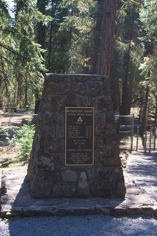
Photograph of Mitchell Recreation Area
Photograph by United States Forest Service, Public domain. Via Wikimedia Commons.

Mitchell Recreation Area

Built in 1950. Listed on the National Register of Historic Places in 2003.

From the record

“Mitchell Recreation Area is a small picnic area located in the Fremont-Winema National Forests, Lake County, Oregon, near the unincorporated community of Bly. In it stands the Mitchell Monument, erected in 1950, which marks the only location in the United States where Americans were killed during World War II as a direct result of a Japanese balloon bomb.”

Wikipedia article Mitchell Recreation Area, CC BY-SA 4.0.

One of 14 National Register listings published here for Lake County · listed in 2003 · category: Site · built in 1950.

Sources: the Wikipedia article · the case file at the National Archives · the National Register database, National Park Service

The listing

  • Address. Forest Service Rd. 34, Fremont National Forest, Bly
  • When was it listed? February 2003
  • Category. site
  • Census division. Lakeview
  • When was it built? 1950
  • National Register reference number. 03000050 - the number the National Park Service assigned this property when it was listed, and the key its nomination file is catalogued under at the National Archives.

Fires near this property

68 since 1992

Regional context, not property-specific evidence. The federal wildfire occurrence database lists 68 fires within 5 miles of Mitchell Recreation Area between 1992 and 2020, burning about 1,150 acres in total. 55 started naturally. 2 were recorded as arson. Distance is straight-line from the map coordinates, so a fire counted here may appear on a neighbouring settlement's page as well.

Reported cause Fires
Natural55
Recreation and ceremony5
Arson/incendiarism2
Missing data/not specified/undetermined2
Debris and open burning2
Equipment and vehicle use1
Smoking1

The most recent of them, most recent first, with the day each was reported and the service that recorded it.

DateCause SizeReported by Name on the report
7 September 2017Naturalunder an acreFremont-Winema National ForestJACK
3 September 2011Recreation and ceremonyunder an acreFremont-Winema National ForestCORRAL
29 September 2019Arson/incendiarism3.2 acresFremont-Winema National ForestUTLEY
28 September 2007Recreation and ceremonyunder an acreFremont-Winema National ForestELDER-295
2 September 1994Naturalunder an acreLake UnitBILL
2 September 1994Naturalunder an acreLake UnitFUDD
16 September 1995Naturalunder an acreLake UnitSTINGER
12 September 2001Naturalunder an acreFremont-Winema National ForestWHISKEY

Every fire recorded in Lake County

Mines and quarries near this property

2 within 5 miles

Regional context, not property-specific evidence. The federal mineral resources record lists 2 workings within 5 miles of Mitchell Recreation Area: 1 past producer, 1 producer. 1 still produces. What was taken out: Stone, Stone, Crushed/Broken. Distance is straight-line from the map coordinates, so a quarry counted here may appear on a neighbouring settlement's page as well.

Where SiteCommodity StatusRecorded
CampbellStonePast Producer
Campbell PitStone, Crushed/BrokenProducer

Every working recorded in Lake County

Map coverage status

No historic map-sheet match is published for this property yet. That does not mean no map exists. This record needs a coordinate-quality review before it can be joined to a sheet boundary. Browse the county's mapped places while that work is pending.

Sources for this property

National Archives recordThe nomination case file for reference 03000050 in Record Group 79.
Wikipedia articleCommunity-written account of this property, licensed CC BY-SA.
Lake CountyAll 14 listed properties in this county.

Provenance

  • Listing record. National Park Service National Register of Historic Places, listed-properties dataset, current to 2026-05-22.
  • Map join. Address geocoded through the United States Census geocoder, then tested against the published boundary of every sheet in the USGS Historical Topographic Map Collection.
  • How this page is made. Listing fields come from federal records; map-sheet coverage is a labelled coordinate-to-boundary calculation, not a source-field claim.
  • Wildfire. Short, Karen C. 2022. Spatial wildfire occurrence data for the United States, 1992-2020 [FPA_FOD_20221014]. 6th Edition. Fort Collins, CO: Forest Service Research Data Archive. https://doi.org/10.2737/RDS-2013-0009.6 Collected with United States Government funding and usable without additional permissions or fees.
  • Mines and quarries. USGS Mineral Resources Data System (MRDS) https://mrdata.usgs.gov/mrds/ A work of the United States government, no copyright under 17 U.S.C. 105.