 Block
From the record
One of 40 National Register listings published here for Coos County · listed in 2015 · category: Building.
Sources: the National Register database, National Park Service
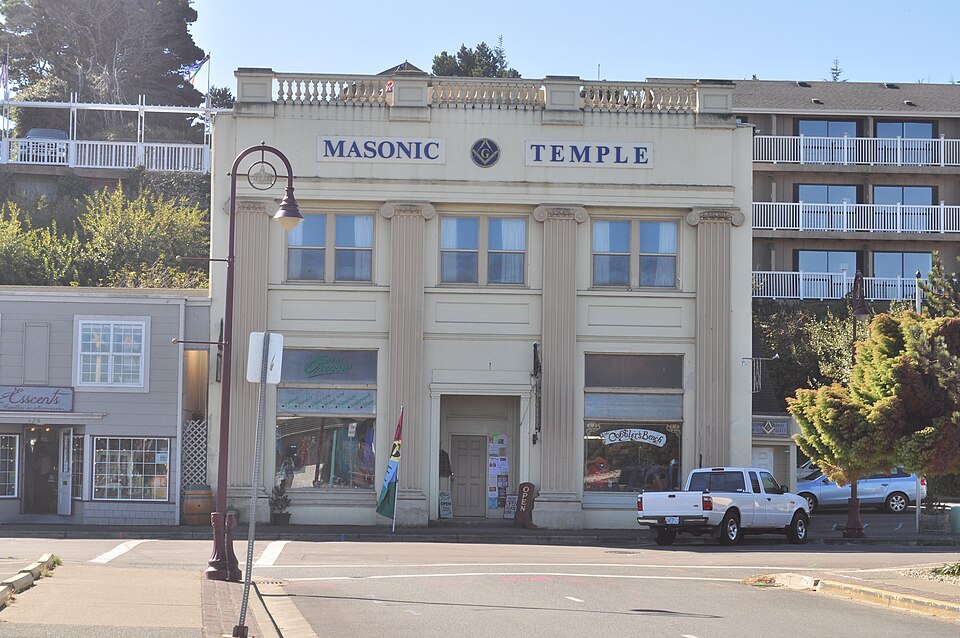
Listed on the National Register of Historic Places in 2015.
One of 40 National Register listings published here for Coos County · listed in 2015 · category: Building.
Sources: the National Register database, National Park Service
Regional context, not property-specific evidence. The federal wildfire occurrence database lists 129 fires within 5 miles of First National Bank of Bandon between 1992 and 2020, burning about 83 acres in total. 9 started naturally. 3 were recorded as arson. Distance is straight-line from the map coordinates, so a fire counted here may appear on a neighbouring settlement's page as well.
| Reported cause | Fires |
|---|---|
| Debris and open burning | 43 |
| Equipment and vehicle use | 19 |
| Recreation and ceremony | 18 |
| Missing data/not specified/undetermined | 11 |
| Natural | 9 |
| Smoking | 8 |
| Fireworks | 7 |
| Power generation/transmission/distribution | 6 |
| Misuse of fire by a minor | 4 |
| Arson/incendiarism | 3 |
| Other causes | 1 |
The most recent of them, most recent first, with the day each was reported and the service that recorded it.
| Date | Cause | Size | Reported by | Name on the report |
|---|---|---|---|---|
| 7 September 2018 | Equipment and vehicle use | 1.0 acres | Oregon Department of Forestry Salem Headquarters | BILL CREEK |
| 5 September 2006 | Debris and open burning | under an acre | Gold Beach Unit | WINDHURST ROAD |
| 3 September 2003 | Power generation/transmission/distribution | under an acre | Gold Beach Unit | PROSPER JUNCTION ROAD |
| 3 September 1995 | Missing data/not specified/undetermined | under an acre | Gold Beach Unit | ROSA ROAD |
| 29 September 2019 | Recreation and ceremony | under an acre | Oregon Department of Forestry Salem Headquarters | CROOKED CREEK |
| 28 September 2015 | Missing data/not specified/undetermined | under an acre | Oregon Department of Forestry Salem Headquarters | WINHURST LANE |
| 28 September 1999 | Debris and open burning | 1.0 acres | Gold Beach Unit | GEIGER CREEK |
| 26 September 2015 | Missing data/not specified/undetermined | under an acre | Oregon Department of Forestry Salem Headquarters | ROSA RD |
Regional context, not property-specific evidence. The federal mineral resources record lists 52 workings within 5 miles of First National Bank of Bandon: 28 past producers, 15 occurrences, 6 producers, 3 prospects. 6 still produce. What was taken out: Sand and Gravel, Construction, Chromium, Gold, Stone. Distance is straight-line from the map coordinates, so a quarry counted here may appear on a neighbouring settlement's page as well.
| Where | Site | Commodity | Status | Recorded |
|---|---|---|---|---|
| Bandon Placer | Titanium, Metal | Producer | Chromite, Ilmenite, Zircon | |
| Bandon Placer | Titanium | Occurrence | ||
| Iowa Mine | Gold, Platinum, Chromium | Past Producer | 1934 | |
| Iowa Mine | Gold, Chromium, Platinum | Past Producer | ||
| The Lagoons | Chromium, Platinum, Gold | Occurrence | Beach Placer | |
| Geiger Creek Mines, Inc. | Gold, Platinum | Occurrence | Beach Placer | |
| Geiger Creek Mines, Inc. | Gold, Platinum | Past Producer | ||
| Jarvis Pit & Plant | Stone | Past Producer | ||
| Jarvis Pit & Plant | Stone | Past Producer | ||
| Johnson Creek Sand & Gravel | Gold | Occurrence |
Regional context, not property-specific evidence. The National Weather Service names Bandon, the town this property stands in, in 12 storm reports between 1998 and 2017: 11 flood, 1 thunderstorm wind. No death or injury is recorded in these reports. Each account below is quoted exactly as the forecast office filed it, from the NOAA Storm Events Database, and each date opens the federal record of that event.
| When | Event | Place named | Harm | What the report says |
|---|---|---|---|---|
| January 2017 | Flood | Bandon | - | The Coquille River at Coquille rose above flood stage (21.0 feet) at 10/0330 PST and rose above moderate flood stage (23.0 feet) at 11/0100 PST. The river crested at 23.55 feet at 11/1245 PST. The river fell below moderate flood stage at 12/1745 PST and below flood stage at 13/1700 PST. |
| February 2017 | Flood | Bandon | - | The Coquille River near Coquille exceeded flood stage (21.0 feet) at 09/1330 PST, then exceeded moderate flood stage (23.0 feet) at 10/0200 PST. The river crested at 23.60 feet at 10/0545 PST. The river fell below moderate flood stage at 11/0615 PST and below flood stage at 12/0800 PST. |
| February 2017 | Flood | Bandon | - | The Coquille River at Coquille rose above flood stage (21.0 feet) at 22/0615 PST. The river crested at 22.49 feet at 23/0130 PST. It fell below flood stage sometime between 23/1130 PST and 24/1330 PST. The exact time could not be determined due to a data outage. |
| January 2016 | Flood | Bandon | - | The Coquille River at Coquille exceeded the flood stage of 21.0 feet at 18/0752 PST. It crested at 23.34 feet at 20/1215 PST, which constitutes a moderate flood. It dropped below flood stage at 18/1851 PST. |
| March 2016 | Flood | Bandon | - | The Coquille River at Coquille rose above the flood stage of 21.0 feet at 14/2100 PST. The river crested at 21.71 feet at 15/0915 PST, 15/1015 PST, 15/1115 PST, and 15/2015 PST. The river dropped below flood stage at 16/0200 PST. |
| December 2016 | Flood | Bandon | - | The Coquille River at Coquille rose above flood stage (21.0 feet) at 15/0530 PST, and above moderate flood stage (23.0 feet) at 15/1630 PST. The river crested at 23.64 feet at 15/2145 PST. The river fell below moderate flood stage at 16/1645 PST and below flood stage at 17/1415 PST. |
| February 2015 | Flood | Bandon | - | The Coquille River at Coquille exceeded the flood stage of 21.0 feet at 07/0230 PST and exceeded the moderate flood stage of 23.0 feet at 07/1400 PST. The river crested at 23.62 feet at 07/1830 PST and 07/2000 PST. The river dropped below moderate flood stage at 09/0400 PST and below flood stage at 10/1830 PST. |
| December 2015 | Flood | Bandon | - | The Coquille River at Coquille exceeded the flood stage of 21.0 feet at 21/1805 PST, crested above moderate flood stage at 23.17 feet at 23/2000 PST, then fell below flood stage at 26/1942 PST. |
| December 2015 | Flood | Bandon | - | The Coquille River at Coquille exceeded the flood stage of 21.0 feet at 11/0219 PST, crested above moderate flood stage at 24.46 feet at 13/2100 PST, then fell below flood stage at 16/2050 PST. |
| December 2015 | Flood | Bandon | - | The Coquille River at Coquille exceeded the flood stage of 21.0 feet at 17/2045 PST, crested above moderate flood stage at 24.22 feet at 18/2300 PST, then fell below flood stage at 21/0945 PST. |
| December 2014 | Flood | Bandon | - | The Coquille River at Coquille exceeded the minor flood stage of 21.0 feet at 21/1230 PST and exceeded the moderate flood stage of 23.0 feet at 21/2030 PST. The river crested at 24.17 feet between 22/1030 and 22/1045 PST. The river dropped below moderate flood stage at 24/0015 PST, and dropped below minor flood stage at 26/1400 PST. |
| January 1998 | Thunderstorm Wind | Bandon | - | Trees down from thunderstorm winds. |
No historic map-sheet match is published for this property yet. That does not mean no map exists. This record needs a coordinate-quality review before it can be joined to a sheet boundary. Browse the county's mapped places while that work is pending.
Other National Register properties close enough to walk or drive between, ordered by distance from this one. Both positions come from the same geocoding pass that matched these properties to their map sheets.
| Photograph | Property | Distance | Listed |
|---|---|---|---|
 | Coquille River Life Boat Station | 0.2 miles | 1984 |
 | Coquille River Light | 0.2 miles | 1974 |
 | Breuer Building | 0.2 miles | 1992 |
| National Archives record | The nomination case file for reference 15000373 in Record Group 79. |
| Coos County | All 40 listed properties in this county. |