 Block
From the record
One of 28 National Register listings published here for Klamath County · listed in 1979 · category: Building · built in 1911.
Sources: the case file at the National Archives · the National Register database, National Park Service
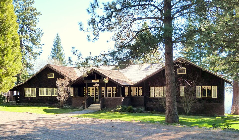
Built in 1911. Listed on the National Register of Historic Places in 1979.
One of 28 National Register listings published here for Klamath County · listed in 1979 · category: Building · built in 1911.
Sources: the case file at the National Archives · the National Register database, National Park Service
Regional context, not property-specific evidence. The federal wildfire occurrence database lists 97 fires within 5 miles of Point Comfort Lodge between 1992 and 2020, burning about 99 acres in total. 54 started naturally. 2 were recorded as arson. Distance is straight-line from the map coordinates, so a fire counted here may appear on a neighbouring settlement's page as well.
| Reported cause | Fires |
|---|---|
| Natural | 54 |
| Recreation and ceremony | 17 |
| Missing data/not specified/undetermined | 12 |
| Debris and open burning | 6 |
| Smoking | 4 |
| Equipment and vehicle use | 2 |
| Arson/incendiarism | 2 |
The most recent of them, most recent first, with the day each was reported and the service that recorded it.
| Date | Cause | Size | Reported by | Name on the report |
|---|---|---|---|---|
| 7 September 2014 | Recreation and ceremony | under an acre | Oregon Department of Forestry Salem Headquarters | HOUSE DISP#636 |
| 7 September 2012 | Missing data/not specified/undetermined | under an acre | Fremont-Winema National Forest | TAMARAK |
| 6 September 2012 | Missing data/not specified/undetermined | under an acre | Fremont-Winema National Forest | BARBER |
| 5 September 2019 | Natural | under an acre | Fremont-Winema National Forest | VARNEY |
| 5 September 2019 | Natural | under an acre | Oregon Department of Forestry Salem Headquarters | PARAGON 355 |
| 5 September 2013 | Natural | under an acre | Fremont-Winema National Forest | DOUBLE TREE |
| 25 September 2012 | Missing data/not specified/undetermined | under an acre | Fremont-Winema National Forest | TOMAHAWK |
| 20 September 2020 | Recreation and ceremony | under an acre | Fremont-Winema National Forest | ASPEN |
Regional context, not property-specific evidence. The federal mineral resources record lists 2 workings within 5 miles of Point Comfort Lodge: 1 past producer, 1 producer. 1 still produces. What was taken out: Stone, Crushed/Broken, Pumice. Distance is straight-line from the map coordinates, so a quarry counted here may appear on a neighbouring settlement's page as well.
| Where | Site | Commodity | Status | Recorded |
|---|---|---|---|---|
| Wampler Cinder Pit | Stone, Crushed/Broken | Past Producer | ||
| Wampler Cinder Pit | Pumice | Producer |
Regional context, not property-specific evidence. The National Weather Service names Klamath Falls, the town this property stands in, in 14 storm reports between 1995 and 2020: 4 hail, 3 flood, 3 wildfire, 3 thunderstorm wind. No death or injury is recorded in these reports. Each account below is quoted exactly as the forecast office filed it, from the NOAA Storm Events Database, and each date opens the federal record of that event.
| When | Event | Place named | Harm | What the report says |
|---|---|---|---|---|
| August 2008 | Thunderstorm Wind | Klamath Falls | $10,000 | A member of the public reported that part of a barn roof was blown away, a firmly anchored car canopy was toppled, and a boat was damaged by strong gusts associated with a thunderstorm. No warning was issued for this storm. |
| August 2020 | Hail | Klamath Falls | - | A member of the public sent a picture of quarter sized hail. |
| May 2006 | Hail | Klamath Falls | - | An NWS employee driving through the area reported .5 to .75 inch hail covering the ground. |
| August 2006 | Thunderstorm Wind | Klamath Falls | - | Klamath County dispatch reported multiple trees down on power lines and roads from Klamath Falls east and north to Chiloquin. |
| June 2004 | Thunderstorm Wind | Klamath Falls | - | No wind report of this magnitude was received, but one report came close. |
| August 1999 | Wildfire | Klamath Falls | - | See below. |
| July 1999 | Wildfire | Klamath Falls | - | See below. |
| July 1999 | Wildfire | Klamath Falls | - | The Klamath Falls Herald and News reported 3 more lightning ignited fires. See below. |
| August 1999 | Flood | Klamath Falls | - | See below. |
| August 1999 | Flood | Klamath Falls | - | See below. |
| May 1995 | Hail | Klamath Falls | - | A small tornado, one and one-half inch hail, and heavy rain accompanied strong thunderstorms in the Klamath Falls area. The tornado ripped the roof off of a Klamath Falls School District bus barn. No one was injured. Hail from the same storm did some minor crop damage to local sugar beet fields. |
| May 1998 | Flash Flood | Klamath Falls | - | no account filed |
| May 1998 | Hail | Klamath Falls | - | no account filed |
| June 1996 | Flood | Klamath Falls | - | no account filed |
No historic map-sheet match is published for this property yet. That does not mean no map exists. This record needs a coordinate-quality review before it can be joined to a sheet boundary. Browse the county's mapped places while that work is pending.
| National Archives record | The nomination case file for reference 79002080 in Record Group 79. |
| Klamath County | All 28 listed properties in this county. |