 Block
From the record
One of 19 National Register listings published here for Lincoln County · listed in 1980 · category: Building.
Sources: the case file at the National Archives · the National Register database, National Park Service
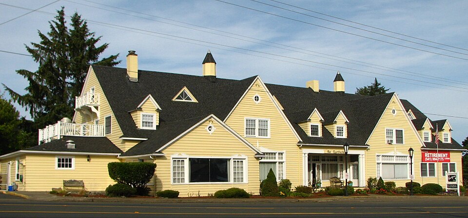
Listed on the National Register of Historic Places in 1980.
One of 19 National Register listings published here for Lincoln County · listed in 1980 · category: Building.
Sources: the case file at the National Archives · the National Register database, National Park Service
Regional context, not property-specific evidence. The federal wildfire occurrence database lists 58 fires within 5 miles of Dorchester House between 1993 and 2016, burning about 27 acres in total. None started naturally. None was recorded as arson. Distance is straight-line from the map coordinates, so a fire counted here may appear on a neighbouring settlement's page as well.
| Reported cause | Fires |
|---|---|
| Recreation and ceremony | 36 |
| Debris and open burning | 10 |
| Equipment and vehicle use | 5 |
| Smoking | 2 |
| Fireworks | 2 |
| Missing data/not specified/undetermined | 2 |
| Other causes | 1 |
The most recent of them, most recent first, with the day each was reported and the service that recorded it.
| Date | Cause | Size | Reported by | Name on the report |
|---|---|---|---|---|
| 3 September 2011 | Recreation and ceremony | under an acre | Toledo Unit | LINCOLN CITY BEACH |
| 25 September 2003 | Equipment and vehicle use | under an acre | Siuslaw National Forest | BURNT TRAILER |
| 2 September 2006 | Recreation and ceremony | 8.9 acres | Toledo Unit | 2200 ROAD |
| 19 September 2014 | Recreation and ceremony | under an acre | Oregon Department of Forestry Salem Headquarters | E. DEVILS LAKE RD FIRE |
| 18 September 2001 | Other causes | under an acre | Toledo Unit | EAST DEVILS LAKE |
| 16 September 2012 | Recreation and ceremony | under an acre | Oregon Department of Forestry Salem Headquarters | 51ST STREET FIRE |
| 15 September 1998 | Recreation and ceremony | under an acre | Toledo Unit | DRIFTWOOD |
| 14 September 2014 | Recreation and ceremony | under an acre | Oregon Department of Forestry Salem Headquarters | ROADS END BEACH FIRE #2 |
Regional context, not property-specific evidence. The federal mineral resources record lists 22 workings within 5 miles of Dorchester House: 12 past producers, 10 producers. 10 still produce. What was taken out: Sand and Gravel, Construction, Stone, Stone, Crushed/Broken, Clay. Distance is straight-line from the map coordinates, so a quarry counted here may appear on a neighbouring settlement's page as well.
| Where | Site | Commodity | Status | Recorded |
|---|---|---|---|---|
| Baldy Creek Quarry | Stone, Crushed/Broken | Producer | ||
| Clay Pit | Clay | Past Producer | ||
| Unnamed Pit | Stone, Crushed/Broken | Producer | ||
| Unnamed Pit | Clay | Producer | ||
| Baldy Creek Quarry | Stone | Past Producer | ||
| Basalt Quarry | Stone | Past Producer | ||
| Devils Lake Quarry | Stone | Past Producer | ||
| Devils Lake Quarry | Stone | Producer | ||
| Ford Sand Pit | Sand and Gravel, Construction | Past Producer | ||
| Lyons Sand Pit | Sand and Gravel, Construction | Past Producer |
Regional context, not property-specific evidence. The National Weather Service names Lincoln City, the town this property stands in, in 3 storm reports between 1996 and 2015: 2 thunderstorm wind, 1 heavy rain. The reports record 1 death and 1 injury. Each account below is quoted exactly as the forecast office filed it, from the NOAA Storm Events Database, and each date opens the federal record of that event.
| When | Event | Place named | Harm | What the report says |
|---|---|---|---|---|
| December 2015 | Heavy Rain | Lincoln City | 1 killed, 1 hurt, $1,240,000 | Heavy rain resulted in a multiple of large land slides from Florence to Newport. A landslide in Newport damaged 6 homes and resulted in the evacuation of other near by homes. A car fell into a sink hole in Newport as it opened up a garage. One landslide that struck a home killed an elderly woman and her dog, and injured her husband. A creek near Yachats River Rd pushed a home off of its foundation as it rerouted from the heavy rain. Highway 229 in Siletz flooded. The Siletz River near Siletz and the Alsea River near Tidewater exceeded flood stage. A new daily rainfall record was set in Newport when 3.08 inches of rain on the 17th broke the previous record of 2 inches that was last set in 1925. |
| January 1996 | Thunderstorm Wind | Lincoln City | $1,500,000 | no account filed |
| December 2010 | Thunderstorm Wind | Lincoln City | - | Strong, gusty winds were reported at Lincoln City with sustained winds of 35 kts and gusts to 53 kts. |
No historic map-sheet match is published for this property yet. That does not mean no map exists. This record needs a coordinate-quality review before it can be joined to a sheet boundary. Browse the county's mapped places while that work is pending.
| National Archives record | The nomination case file for reference 80003337 in Record Group 79. |
| Lincoln County | All 19 listed properties in this county. |