BlockBefore
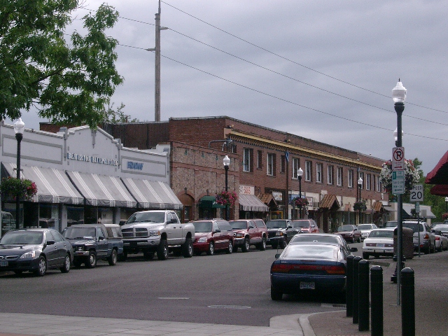
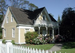
Photograph of Beaverton Downtown Historic District
Photograph by Ajbenj at English Wikipedia, CC BY-SA 3.0. Via Wikimedia Commons.

Beaverton Downtown Historic District

Built in 1868. Listed on the National Register of Historic Places in 1986.

From the record

“The Beaverton Downtown Historic District comprises a primarily commercial and civic portion of downtown Beaverton, Oregon, United States. Beaverton's historic commercial core remains largely intact as a pedestrian-oriented business district constructed along the street pattern from the city's earliest plats.”

Wikipedia article Beaverton Downtown Historic District, CC BY-SA 4.0.

One of 51 National Register listings published here for Washington County · listed in 1986 · category: District · built in 1868.

Sources: the Wikipedia article · the case file at the National Archives · the National Register database, National Park Service
The listing

Mines and quarries near this property

10 of 18 shown

Regional context, not property-specific evidence. The federal mineral resources record lists 18 workings within 5 miles of Beaverton Downtown Historic District: 11 past producers, 5 producers, 1 occurrence, 1 prospect. 5 still produce. What was taken out: Stone, Crushed/Broken, Stone, Sand and Gravel, Construction, Mercury. Distance is straight-line from the map coordinates, so a quarry counted here may appear on a neighbouring settlement's page as well.

Where SiteCommodity StatusRecorded
Portland TunnelMercuryOccurrence
Portland TunnelMercuryProspect
Sylvan Brick CoClayPast Producer
Sylvan Brick CompanyClayPast Producer
Topsil PitSand and Gravel, ConstructionPast Producer
Unnamed PitSand and Gravel, ConstructionProducer
Beaverton QuarryStonePast Producer
Grabhorn QuarryStonePast Producer
Murray Road QuarryStonePast Producer

Every working recorded in Washington County

Storms near this property

7 since 2003

Regional context, not property-specific evidence. The National Weather Service names Beaverton, the town this property stands in, in 7 storm reports between 2003 and 2021: 4 heavy rain, 1 funnel cloud, 1 hail, 1 flood. No death or injury is recorded in these reports. Each account below is quoted exactly as the forecast office filed it, from the NOAA Storm Events Database, and each date opens the federal record of that event.

WhenEvent Place namedHarm What the report says
June 2014Heavy RainBeaverton$140,000Heavy rain from convective showers resulted in significant flooding near Beaverton. Flooding was reported of four homes, four apartments, several garages, the Winterhawks Skating Center, and a community pool. The city Public Works Director reported 2.3 inches of rain per hour, a personal weather station reported 2.29 inches of rain over 2 hours, and the National Weather Service Doppler radar estimated 1.7 inches per hour. A car stalled in a flooded high water in an underpass near the US 26-US 217 interchange. The cost damage is an estimate based on reports from the General Manager of the Skating Center and previous history of similar residential damage.
October 2015Heavy RainBeaverton$50,000Heavy rain combined with clogged drains resulted in small stream and urban flooding. There were 16 instances where water or agricultural debris needed to be cleared from roadways. At least two residential basements were flooded in Beaverton. A large basement of an office building was flooded in Hillsboro.
July 2007HailBeaverton$1,000Hail was reported in Beaverton near Cooper Mountain.
January 2021FloodBeaverton-Road closure at SW 149th Ave. and SW Division St. near South Johnson Creek in Beaverton.
June 2011Heavy RainBeaverton-Thunderstorms produced very heavy rain in Beaverton in a short period of time. A spotter reported over one-half inch of rain in 30 minutes. The Washington County Sheriff Office reported Urban Flooding on several streets as well as Highway 217, which was shut down for a short time.
June 2010Heavy RainBeaverton-An observer reported 1.68 inches of precipitation over the area during a 12 hour period.
April 2003Funnel CloudBeaverton-no account filed

Every storm recorded in Washington County

Map coverage status

No historic map-sheet match is published for this property yet. That does not mean no map exists. This record needs a coordinate-quality review before it can be joined to a sheet boundary. Browse the county's mapped places while that work is pending.

Listed places nearby

6 within 8 miles

Other National Register properties close enough to walk or drive between, ordered by distance from this one. Both positions come from the same geocoding pass that matched these properties to their map sheets.

Photograph PropertyDistance Listed
Augustus Fanno Farmhouse2.0 miles1984
J. F. Watkins House2.2 miles1993
Portland Golf Club Clubhouse and Golf Course2.3 miles2023
M. E. Blanton House2.3 miles1989
Adam and Johanna Feldman House2.3 miles1993
John Quincy Adams and Elizabeth Young House2.8 miles2008

Sources for this property

National Archives recordThe nomination case file for reference 86000037 in Record Group 79.
Wikipedia articleCommunity-written account of this property, licensed CC BY-SA.
Washington CountyAll 51 listed properties in this county.

Provenance

  • Listing record. National Park Service National Register of Historic Places, listed-properties dataset, current to 2026-05-22.
  • Map join. Address geocoded through the United States Census geocoder, then tested against the published boundary of every sheet in the USGS Historical Topographic Map Collection.
  • How this page is made. Listing fields come from federal records; map-sheet coverage is a labelled coordinate-to-boundary calculation, not a source-field claim.
  • Mines and quarries. USGS Mineral Resources Data System (MRDS) https://mrdata.usgs.gov/mrds/ A work of the United States government, no copyright under 17 U.S.C. 105.
  • Storms. NOAA National Centers for Environmental Information, Storm Events Database https://www.ncei.noaa.gov/stormevents/ A work of the United States government, no copyright under 17 U.S.C. 105. Narratives are quoted verbatim from the National Weather Service report and are not edited or summarised.