
BlockBefore
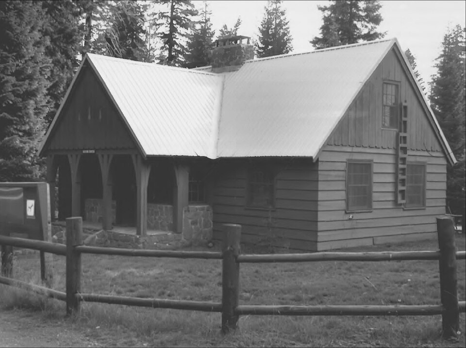
Photograph of Lake of the Woods Ranger Station
Photograph by United States Forest Service (Richard Scott), Public domain. Via Wikimedia Commons.

Lake of the Woods Ranger Station-Work Center

Listed on the National Register of Historic Places in 1986.

From the record

“The Lake of the Woods Ranger Station is a United States Forest Service compound consisting of eight buildings overlooking Lake of the Woods in the Fremont-Winema National Forests of southern Oregon. All of the ranger station structures were built by the Civilian Conservation Corps between 1937 and 1939.”

Wikipedia article Lake of the Woods Ranger Station, CC BY-SA 4.0.

One of 28 National Register listings published here for Klamath County · listed in 1986 · category: Building.

Sources: the Wikipedia article · the case file at the National Archives · the National Register database, National Park Service

The listing

  • What is counted as historic. The nomination lists 8 buildingss as contributing to the listing.
  • Listed as. Lake of the Woods Ranger Station--Work Center - the National Register files a house under its owner's surname.
  • Address. Winema National Forest, Klamath Falls, 97601
  • When was it listed? April 1986
  • Category. building
  • Also known as. Depression-Era Buildings Oregon and Washington TR
  • Census division. Keno
  • Architectural style. Forest Service rustic
  • Architect. United States Forest Service
  • National Register reference number. 86000845 - the number the National Park Service assigned this property when it was listed, and the key its nomination file is catalogued under at the National Archives.

Fires near this property

131 since 1992

Regional context, not property-specific evidence. The federal wildfire occurrence database lists 131 fires within 5 miles of Lake of the Woods Ranger Station-Work Center between 1992 and 2019, burning about 40 acres in total. 73 started naturally. 2 were recorded as arson. Distance is straight-line from the map coordinates, so a fire counted here may appear on a neighbouring settlement's page as well.

Reported cause Fires
Natural73
Recreation and ceremony28
Missing data/not specified/undetermined14
Misuse of fire by a minor4
Equipment and vehicle use4
Smoking3
Arson/incendiarism2
Other causes1
Debris and open burning1
Power generation/transmission/distribution1

The most recent of them, most recent first, with the day each was reported and the service that recorded it.

DateCause SizeReported by Name on the report
7 September 2017Naturalunder an acreRogue River-Siskiyou National ForestBUTTE CREEK
7 September 2012Missing data/not specified/undeterminedunder an acreFremont-Winema National ForestTAMARAK
6 September 2012Missing data/not specified/undeterminedunder an acreFremont-Winema National ForestBARBER
5 September 2005Recreation and ceremonyunder an acreFremont-Winema National ForestBBQ
5 September 2003Naturalunder an acreFremont-Winema National ForestBILLIE GOAT
5 September 2003Naturalunder an acreFremont-Winema National ForestFAMILY
4 September 1999Recreation and ceremonyunder an acreFremont-Winema National ForestPEARCE
3 September 2013Naturalunder an acreRogue River-Siskiyou National ForestBROWN MOUNTAIN

Every fire recorded in Klamath County

Storms near this property

14 since 1995

Regional context, not property-specific evidence. The National Weather Service names Klamath Falls, the town this property stands in, in 14 storm reports between 1995 and 2020: 4 hail, 3 flood, 3 wildfire, 3 thunderstorm wind. No death or injury is recorded in these reports. Each account below is quoted exactly as the forecast office filed it, from the NOAA Storm Events Database, and each date opens the federal record of that event.

WhenEvent Place namedHarm What the report says
August 2008Thunderstorm WindKlamath Falls$10,000A member of the public reported that part of a barn roof was blown away, a firmly anchored car canopy was toppled, and a boat was damaged by strong gusts associated with a thunderstorm. No warning was issued for this storm.
August 2020HailKlamath Falls-A member of the public sent a picture of quarter sized hail.
May 2006HailKlamath Falls-An NWS employee driving through the area reported .5 to .75 inch hail covering the ground.
August 2006Thunderstorm WindKlamath Falls-Klamath County dispatch reported multiple trees down on power lines and roads from Klamath Falls east and north to Chiloquin.
June 2004Thunderstorm WindKlamath Falls-No wind report of this magnitude was received, but one report came close.
August 1999WildfireKlamath Falls-See below.
July 1999WildfireKlamath Falls-See below.
July 1999WildfireKlamath Falls-The Klamath Falls Herald and News reported 3 more lightning ignited fires. See below.
August 1999FloodKlamath Falls-See below.
May 1995HailKlamath Falls-A small tornado, one and one-half inch hail, and heavy rain accompanied strong thunderstorms in the Klamath Falls area. The tornado ripped the roof off of a Klamath Falls School District bus barn. No one was injured. Hail from the same storm did some minor crop damage to local sugar beet fields.
May 1998Flash FloodKlamath Falls-no account filed
May 1998HailKlamath Falls-no account filed
June 1996FloodKlamath Falls-no account filed

Every storm recorded in Klamath County

Map coverage status

No historic map-sheet match is published for this property yet. That does not mean no map exists. This record needs a coordinate-quality review before it can be joined to a sheet boundary. Browse the county's mapped places while that work is pending.

Sources for this property

National Archives recordThe nomination case file for reference 86000845 in Record Group 79.
Wikipedia articleCommunity-written account of this property, licensed CC BY-SA.
Klamath CountyAll 28 listed properties in this county.

Provenance

  • Listing record. National Park Service National Register of Historic Places, listed-properties dataset, current to 2026-05-22.
  • Map join. Address geocoded through the United States Census geocoder, then tested against the published boundary of every sheet in the USGS Historical Topographic Map Collection.
  • How this page is made. Listing fields come from federal records; map-sheet coverage is a labelled coordinate-to-boundary calculation, not a source-field claim.
  • Wildfire. Short, Karen C. 2022. Spatial wildfire occurrence data for the United States, 1992-2020 [FPA_FOD_20221014]. 6th Edition. Fort Collins, CO: Forest Service Research Data Archive. https://doi.org/10.2737/RDS-2013-0009.6 Collected with United States Government funding and usable without additional permissions or fees.
  • Storms. NOAA National Centers for Environmental Information, Storm Events Database https://www.ncei.noaa.gov/stormevents/ A work of the United States government, no copyright under 17 U.S.C. 105. Narratives are quoted verbatim from the National Weather Service report and are not edited or summarised.