BlockBefore
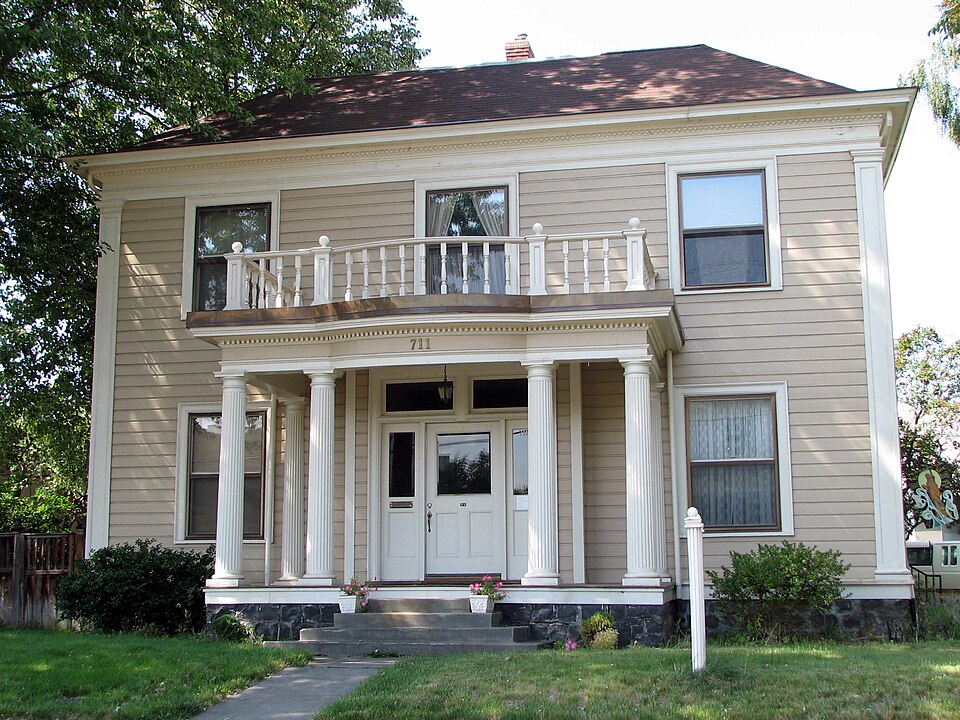
Photograph of Ellis-Hampton House
Photograph by Ian Poellet, CC BY-SA 3.0. Via Wikimedia Commons.

Ellis-Hampton House

Built in 1901 (Colonial Revival architecture). Listed on the National Register of Historic Places in 1986.

From the record

One of 43 National Register listings published here for Umatilla County · listed in 1986 · category: Building · built in 1901, Colonial Revival architecture.

Sources: the case file at the National Archives · the National Register database, National Park Service

The listing

  • What is counted as historic. The nomination lists 1 building as contributing to the listing.
  • Listed as. Ellis--Hampton House - the National Register files a house under its owner's surname.
  • Address. 711 S.E. Byers Ave., Pendleton, 97801
  • When was it listed? October 1986
  • Category. building
  • Census division. Pendleton
  • When was it built? 1901
  • Architectural style. Colonial Revival architecture
  • National Register reference number. 86002909 - the number the National Park Service assigned this property when it was listed, and the key its nomination file is catalogued under at the National Archives.

Fires near this property

115 since 1992

Regional context, not property-specific evidence. The federal wildfire occurrence database lists 115 fires within 5 miles of Ellis-Hampton House between 1992 and 2020, burning about 2,261 acres in total. 3 started naturally. 7 were recorded as arson. Distance is straight-line from the map coordinates, so a fire counted here may appear on a neighbouring settlement's page as well.

Reported cause Fires
Debris and open burning26
Equipment and vehicle use22
Missing data/not specified/undetermined18
Power generation/transmission/distribution13
Railroad operations and maintenance12
Arson/incendiarism7
Smoking5
Recreation and ceremony4
Natural3
Fireworks3
Other causes2

The most recent of them, most recent first, with the day each was reported and the service that recorded it.

DateCause SizeReported by Name on the report
9 September 2005Power generation/transmission/distributionunder an acreUmatilla AgencyPOWERPOLE
9 September 1995Railroad operations and maintenanceunder an acreUmatilla AgencyUPRR7
7 September 2006Other causesunder an acreUmatilla AgencyHAYSTACK
5 September 2019Natural63 acresUmatilla AgencyTUTUILLA CREEK
4 September 2018Debris and open burning5.8 acresUmatilla AgencyLLYOD ROAD
3 September 2003Debris and open burning3.0 acresUmatilla AgencyMCCOY
24 September 1999Equipment and vehicle use100 acresUmatilla AgencyDOGSLEEP
21 September 2014Equipment and vehicle useunder an acreUmatilla AgencyMILE POST 215

Every fire recorded in Umatilla County

Mines and quarries near this property

10 of 36 shown

Regional context, not property-specific evidence. The federal mineral resources record lists 36 workings within 5 miles of Ellis-Hampton House: 30 past producers, 6 producers. 6 still produce. What was taken out: Stone, Stone, Crushed/Broken, Sand and Gravel, Construction. Distance is straight-line from the map coordinates, so a quarry counted here may appear on a neighbouring settlement's page as well.

Where SiteCommodity StatusRecorded
404 QuarrySand and Gravel, ConstructionPast ProducerSedimentary
404 QuarrySand and Gravel, ConstructionProducer
Gravel PitSand and Gravel, ConstructionPast Producer
Mission PitSand and Gravel, ConstructionPast Producer
Mission PitSand and Gravel, ConstructionProducer
Pendleton MissionSand and Gravel, ConstructionPast Producer
Pendleton Mission PitSand and Gravel, ConstructionProducer
Pendleton Ready MixSand and Gravel, ConstructionPast Producer
Sand & Gravel PlantSand and Gravel, ConstructionPast Producer
Boggotti PitStone, Crushed/BrokenPast Producer

Every working recorded in Umatilla County

Storms near this property

27 since 1995

Regional context, not property-specific evidence. The National Weather Service names Pendleton, the town this property stands in, in 27 storm reports between 1995 and 2020: 15 thunderstorm wind, 3 lightning, 3 funnel cloud, 3 hail. No death or injury is recorded in these reports. Each account below is quoted exactly as the forecast office filed it, from the NOAA Storm Events Database, and each date opens the federal record of that event.

WhenEvent Place namedHarm What the report says
April 2019FloodPendleton$5,000,000A combination of high flows from rain and snow melt coming out of the Blue Mountains and record releases out of McKay Reservoir produced field and roadside flooding downstream of Pendleton through Echo, Hermiston and Umatilla. A footbridge at Umatilla was damaged by the high flows and erosion.
June 2008Thunderstorm WindPendleton$50,000Semi-truck and pickup with camper were flipped over on Interstate 84.
July 1995Thunderstorm WindPendleton$15,000Thunderstorm winds toppled an old concrete and wood wall in Pendleton, crushing several cars under the falling debris. Tall trees were also blown down in SE Pendleton.
June 2008Thunderstorm WindPendleton$7,000Damage to roof and dozens of large branches downed. Two trees uprooted near the Pendleton High School.
May 2010Thunderstorm WindPendleton$5,000Shingles blown off roof during thunderstorm.
May 2009Thunderstorm WindPendleton$5,000Downed tree branches caused power outage. A 20 foot tall lilac bush was uprooted and shingles were torn off roofs.
June 2008Thunderstorm WindPendleton$5,000Umatilla Electric Coop reports trees blown down on power lines in several locations between Pendleton and Nolin.
July 1995Thunderstorm WindPendleton$5,000An area of vigorous thunderstorms hit the Pendleton area in mid-afternoon. Trees were blown down and visibility at the airport was reduced to one-quarter mile in blowing dust by winds gusting to 55 mph.
May 1995Thunderstorm WindPendleton$5,000Thunderstorm wind blew sheets of metal roofing off of a gas station at U.S. Highway 30 and Airport Road. No injuries were reported.
February 2000Heavy RainPendleton$4,000Steady rain fell all day and washed mud and other debris on several city streets. Both Coombs Canyon and Adams Roads were briefly closed as maintenance crews unplugged some drains. This rain, which totaled 0.93 inches at the Pendleton Airport, also washed out a section of Wildhorse Road near Weston.
August 2004LightningPendleton$1,000no account filed
May 2011LightningPendleton$500Lightning struck the attic of a residence and blew out the power and sent sheetrock flying off the walls downstairs. The lightning also struck a bathroom vent on the neighbor's house.
June 2017Thunderstorm WindPendleton-Measured gust to 64 mph by the ASOS at the Pendleton airport.
May 2015Thunderstorm WindPendleton-Public reported trees snapped or uprooted due to high winds from a thunderstorm.
April 2013Thunderstorm WindPendleton-Downed trees, damage to a home, power lines down, and a barn destroyed.
September 2013Thunderstorm WindPendleton-Gust of 64 mph was measured by the weather station at the Pendleton WFO.
September 2013Thunderstorm WindPendleton-Three foot diameter tree split from high winds, part of the tree fell onto a pickup truck bed.
April 2011Funnel CloudPendleton-Public reported a shaft of rotation along with a wall cloud in a thunderstorm.
April 2010HailPendleton-Dime size hail reported.
May 2000Funnel CloudPendleton-A small funnel cloud that descended a couple hundred feet from a thunderstorm was observed from the National Weather Service forecast office by an off duty forecaster. This funnel lasted for around 15 seconds.
August 1997Thunderstorm WindPendleton-Thunderstorm wind gusted to 59 mph at the Pendleton Airport.
May 1997LightningPendleton-A power pole cought fire and caused power and cable TV outages in southeast Pendleton.
May 2020HailPendleton-no account filed
May 2016Thunderstorm WindPendleton-no account filed
March 2014FloodPendleton-no account filed
August 2004Funnel CloudPendleton-no account filed
May 2000HailPendleton-no account filed

Every storm recorded in Umatilla County

Map coverage status

No historic map-sheet match is published for this property yet. That does not mean no map exists. This record needs a coordinate-quality review before it can be joined to a sheet boundary. Browse the county's mapped places while that work is pending.

Listed places nearby

6 within 8 miles

Other National Register properties close enough to walk or drive between, ordered by distance from this one. Both positions come from the same geocoding pass that matched these properties to their map sheets.

Photograph PropertyDistance Listed
Edgar Sommerville House0.2 miles1980
LaDow Block0.3 miles1992
Johnson-Ellis House0.3 miles1986
Hamley and Company Leather Goods Store0.4 miles1982
Joseph Vey House0.4 miles1986
Milarkey Building0.4 miles1982

Sources for this property

National Archives recordThe nomination case file for reference 86002909 in Record Group 79.
Umatilla CountyAll 43 listed properties in this county.

Provenance

  • Listing record. National Park Service National Register of Historic Places, listed-properties dataset, current to 2026-05-22.
  • Map join. Address geocoded through the United States Census geocoder, then tested against the published boundary of every sheet in the USGS Historical Topographic Map Collection.
  • How this page is made. Listing fields come from federal records; map-sheet coverage is a labelled coordinate-to-boundary calculation, not a source-field claim.
  • Wildfire. Short, Karen C. 2022. Spatial wildfire occurrence data for the United States, 1992-2020 [FPA_FOD_20221014]. 6th Edition. Fort Collins, CO: Forest Service Research Data Archive. https://doi.org/10.2737/RDS-2013-0009.6 Collected with United States Government funding and usable without additional permissions or fees.
  • Mines and quarries. USGS Mineral Resources Data System (MRDS) https://mrdata.usgs.gov/mrds/ A work of the United States government, no copyright under 17 U.S.C. 105.
  • Storms. NOAA National Centers for Environmental Information, Storm Events Database https://www.ncei.noaa.gov/stormevents/ A work of the United States government, no copyright under 17 U.S.C. 105. Narratives are quoted verbatim from the National Weather Service report and are not edited or summarised.